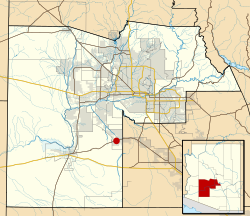
Maricopa County is in the south-central part of the U.S. state of Arizona. As of the 2020 census, the population was 4,420,568, making it the state's most populous county, and the fourth-most populous in the United States. It contains about 62% of Arizona's population, making Arizona one of the most centralized states in the nation. The county seat is Phoenix, the state capital and fifth-most populous city in the United States.

Buckeye is a city in Maricopa County, Arizona, United States, and is the westernmost suburb in the Phoenix metropolitan area. As of the 2020 census the population was 91,502, up from 50,876 in 2010 and 6,537 in 2000. It was the fastest-growing city in the United States for both 2017 and 2018.

Goodyear is a city in Maricopa County, Arizona, United States. It is a suburb of Phoenix and at the 2020 census had a population of 95,294, up from 65,275 in 2010 and 18,911 in 2000. It was the third-fastest-growing city in Arizona between 1990 and 2000.

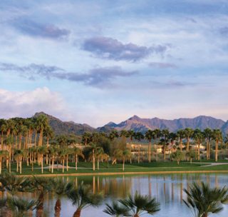
Litchfield Park is a city in Maricopa County, Arizona, United States. It is located 19 miles (31 km) west of Phoenix. As of the 2020 census, the population of the city was 6,847, up from 5,476 in 2010.

Scottsdale is a city in the eastern part of Maricopa County, Arizona, United States, and is part of the Phoenix metropolitan area. Named Scottsdale in 1894 after its founder Winfield Scott, a retired U.S. Army chaplain, the city was incorporated in 1951 with a population of 2,000. As of the 2020 census, the population was 241,361, up from 217,385 in 2010. Its slogan is "The West's Most Western Town". It has been one of the fastest growing cities in the United States over the past decades.
Maricopa is a city in the Gila River Valley in Pinal County, Arizona, United States. With 62,720 residents as of 2021, Maricopa is the largest incorporated municipality in Pinal County which forms part of the Phoenix metropolitan area.
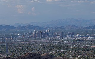
The Phoenix Metropolitan Area – also the Valley of the Sun, the Salt River Valley, or Metro Phoenix – is the largest metropolitan area in the Southwestern United States, centered on the city of Phoenix, that includes much of the central part of Arizona. The United States Office of Management and Budget designates the area as the Phoenix-Mesa-Chandler Metropolitan Statistical Area (MSA), defining it as Maricopa and Pinal counties. As of the 2020 census, Metro Phoenix had 4,845,832 residents, making it the 11th largest metropolitan area in the nation by population. It anchors the Arizona Sun Corridor megaregion along with the second most populous metropolitan area in the state, the Tucson metropolitan area. The gross domestic product of the Phoenix Metropolitan Area was $255 billion in 2018, 16th largest amongst metro areas in the United States.

Sonoyta, Sonora is a town in the northern Mexican state of Sonora. It stands on the U.S.-Mexico border, facing Lukeville, Arizona, in the United States. It is the municipal seat of the municipality of Plutarco Elías Calles.
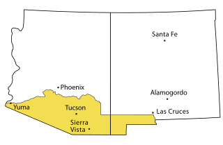
Southern Arizona is a region of the United States comprising the southernmost portion of the State of Arizona. It sometimes goes by the name Gadsden or Baja Arizona, which means "Lower Arizona" in Spanish.

The White Tank Mountain Regional Park is a large regional park located in west-central Maricopa County, Arizona. Encompassing 29,271 acres of desert and mountain landscape, it is the largest regional park in the county. The bulk of the White Tank Mountains range is located within the park's boundaries.

Phoenix Goodyear Airport is a public airport 1.15 miles southwest of Goodyear, in Maricopa County, Arizona, United States.
Estrella Falls is a planned regional shopping mall and mixed-use complex in Goodyear, Arizona, about 20 miles west of downtown Phoenix. Two segments of the planned development, first proposed in 2005, have opened: a retail power centre called The Market at Estrella Falls, and a multiplex theater, Harkins Estrella Falls 16. Other parts of the site have been replanned and construction of the Goodyear Civic Square at Estrella Falls, to include a new civic center for the city, is expected to begin in 2021.
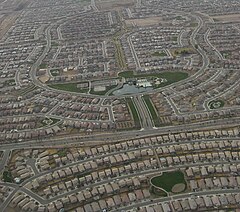
Estrella is a mixed-use master-planned community located in Goodyear, Arizona, in the United States. Encompassing roughly 20,000 acres, the lakeside community is nestled in the foothills of the Sierra Estrella Mountains, in the Sonoran Desert Valley. Located approximately 17 miles west of Phoenix off the I-10 and Estrella Parkway, the community offers has access to the Greater Metro-Phoenix area. Currently, Estrella is home to more than 40,000 residents ranging from young couples to retirees. The community hosts regular events, and has amenities including parks, trails and open space. Estrella currently comprises three distinct communities – Mountain Ranch, Montecito and the gated, 55-Plus CantaMia.
San Tan Valley is an unincorporated community and census-designated place in northern Pinal County, Arizona, United States. As of the census of 2020, the population of San Tan Valley is 99,894.

The Palo Verde Valley is located in the Lower Colorado River Valley, next to the eastern border of Southern California with Arizona, United States. It is located on the Colorado Desert within the Sonoran Desert south of the Parker Valley. Most of the valley is in Riverside County, with the southern remainder in Imperial County. La Paz County borders to the east on the Colorado River.

The Phoenix Metropolitan Area consists of a valley that has multiple city regions in it. The East Valley is a multi-city region within the Phoenix Metropolitan Area of Arizona. East Valley is a loosely defined region, with differing definition of what constitutes it.

Deer Valley or Deer Valley Village is one of the 15 urban villages that make up Phoenix, Arizona, United States. As of 2010, the population was 165,656, 25% of whom were under 18 years of age. The origin of the name is unclear; it first appeared on a 1921 General Land Office map of the area describing the valley created by Skunk Creek.
There is a current proposal to bring commuter rail service to the Phoenix, Arizona metropolitan area.
Belmont is a proposed planned city in the Phoenix metropolitan area of Arizona, United States. The development, a partnership between billionaire philanthropist Bill Gates and local real estate investors, will be a "smart city" designed around emerging technologies. It will be located in the West Valley area, along Interstate 10 near Tonopah.
Guinea Town Settlement, Hyde Park is located in Hudson Valley, New York and was a thriving African American settlement in the 1790s to 1850 built by free and runaway, formerly enslaved Blacks. It was a settlement of over 60 families at its peak. Guinea Town was part of the Underground Railroad that assisted in the transport of runaway slaves to Nova Scotia, Canada.