Related Research Articles

Clark County is located in the U.S. state of Nevada. As of the 2010 census, the population was 1,951,269, with an estimated population of 2,266,715 in 2019. Most of the county population resides in the Las Vegas Census County Divisions, which hold 1,771,945 people as of the 2010 Census, across 476 square miles (1,233 km2). It is by far the most populous county in Nevada, and the 11th most populous county in the United States. It covers 7% of the state's land area but holds 74% of the state's population, making Nevada one of the most centralized states in the United States.

Mohave or Mojave are a Native American people indigenous to the Colorado River in the Mojave Desert. The Fort Mojave Indian Reservation includes territory within the borders of California, Arizona, and Nevada. The Colorado River Indian Reservation includes parts of California and Arizona and is shared by members of the Chemehuevi, Hopi, and Navajo peoples.

Mohave County is in the northwestern corner of the U.S. state of Arizona. As of the 2010 census, its population was 200,186. The county seat is Kingman, and the largest city is Lake Havasu City. It is the fifth largest county in the United States.

Bullhead City is a city located on the Colorado River in Mohave County, Arizona, United States, roughly 90 mi (140 km) south of Las Vegas, Nevada, and directly across the Colorado River from Laughlin, Nevada, whose casinos and ancillary services supply much of the employment for Bullhead City. Bullhead City is located on the southern border of Lake Mohave. According to the 2010 census, the population of the city is 39,540. The nearby communities of Laughlin, Needles, California, Fort Mohave and Mohave Valley bring the Bullhead area's total population to about 100,000, making it the largest micropolitan area in Mohave County.

Mohave Valley is a census-designated place (CDP) in Mohave County, Arizona, United States. The population was 13,694 at the 2000 census. It is geographically connected to Needles, California, Fort Mohave and Bullhead City.

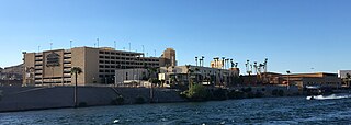
Laughlin is an unincorporated resort town and census-designated place in Clark County, Nevada, United States. It is located on the Colorado River, directly across from the much larger Bullhead City, Arizona. Laughlin lies 90 miles (140 km) south of Las Vegas, in the far southern tip of Nevada, and is known for its gaming and water recreation. As of the 2010 census, the population was 7,323. The nearby communities of Bullhead City, Arizona; Needles, California; Fort Mohave, Arizona; and Mohave Valley, Arizona, bring the area's total population to about 100,000. Laughlin is also 286 miles (460 km) northeast of Los Angeles.

The Fort Mohave Indian Reservation is an Indian reservation along the Colorado River, currently encompassing 23,669 acres (95.79 km2) in Arizona, 12,633 acres (51.12 km2) in California, and 5,582 acres (22.59 km2) in Nevada. The reservation is home to approximately 1,100 members of the federally recognized Fort Mojave Indian Tribe of Arizona, California, and Nevada, a federally recognized tribe of Mohave people.

The Mohave Valley is a valley located mostly on the east shore of the south-flowing Colorado River in northwest Arizona. The valley extends into California's San Bernardino County; the northern side of the valley extends into extreme southeast Clark County, Nevada. The main part of the valley lies in southwest Mohave County, Arizona and is at the intersection of the southeast Mojave and northwest Sonoran deserts.
The Golden Nugget Laughlin is a hotel and casino located on the banks of the Colorado River in Laughlin, Nevada. It is owned and operated by Landry's, Inc. It offers a number of restaurants, 300 guest rooms and suites, a casino floor, and meeting spaces. The Golden Nugget offers water taxi service from Bullhead City, Arizona, on the opposite side of the river.
The Laughlin River Lodge is a hotel and casino on the banks of the Colorado River in Laughlin, Nevada. It is owned and operated by Richard Craig Estey. The property includes a 41,000 sq ft (3,800 m2) casino and 1,000 hotel rooms in a 25-story tower. The resort has 653 slot machines and a bingo parlor.

The Aquarius Casino Resort is a hotel and casino located on the banks of the Colorado River in Laughlin, Nevada. It is owned and operated by Golden Entertainment and is the largest hotel in Laughlin.

Avi Resort & Casino is a hotel and casino located near the southern tip of Nevada on the banks of the Colorado River in Laughlin, Nevada, next to Fort Mohave, Arizona. Within walking distance of the California and Arizona borders, it is owned by the Fort Mojave Tribe and operated by Warner Gaming. It has a 465-room hotel, a 25,000 sq ft (2,300 m2) casino and a 260-space RV park with internet access.

Lanfair Valley is located in the Mojave Desert in southeastern California near the Nevada state line. It is bounded on the north by the New York Mountains and Castle Mountains, on the east by the Piute Range, and on the south by the Woods Mountains and Vontrigger Hills. Joshua Trees can be found in most of the valley. Elevation is 4,045 feet.

The Colorado River Indian Tribes is a federally recognized tribe consisting of the four distinct ethnic groups associated with the Colorado River Indian Reservation: Chemehuevi, the Mohave, Hopi, and Navajo. The tribe has about 4,277 enrolled members. A total population of 9,485 currently resides within the tribal reservation according to the 2012-2016 American Community Survey data.

The Mojave Road, also known as Old Government Road, is a historic route and present day dirt road across what is now the Mojave National Preserve in the Mojave Desert in the United States. This rough road stretched 147 miles (237 km) from Beale's Crossing, to Fork of the Road location along the north bank of the Mojave River where the old Mojave Road split off from the route of the Old Spanish Trail/Mormon Road.

Mohave City is a ghost town in Mohave County in the northwestern part of the U.S. state of Arizona. Settled in the 1860s, in what was then the Arizona Territory, it was founded as a river landing and trading center for area miners and soldiers, and was named for Mohave County.

Fort Mohave is a CDP in Mohave County, Arizona, United States. It is named for a nearby fort that was used during the Mohave War. As of the census of 2010, the population of Fort Mohave was 14,364, a figure which was 8,919 in 2000. It is a micro-suburb of Bullhead City. Its recent growth has made it the most populous unincorporated community in Mohave County.
Beaver Lake was a lake on the west side of the Colorado River in what is now Clark County, Nevada. Beaver Lake lay on a north–south axis, almost entirely within the boundaries of the Camp Mohave Military Reservation. The southern end of the lake was a mile and half west of Fort Mohave and its northern end was located about 2 miles northwest of the camp. The Mojave Road passed by the northern extremity of the lake. Since 1892 the lake has dried up and have returned to desert or been made into farmland. It appears as a depression running north and south, west of the river at an elevation of 490 feet or less.
Beale's Crossing was a river crossing on the Colorado River, near the head of the Mohave Valley, between New Mexico Territory and California along the 35th Parallel route of Beale's Wagon Road. It was at what became the site of Fort Mohave in what is now Fort Mohave, Arizona, west of Beaver Lake, Nevada. It was named for Edward Fitzgerald Beale, who lead the expedition that built what came to be called Beale's Wagon Road from Albuquerque, New Mexico to Beale's Crossing in California, then by way of the Mohave Trail/Old Spanish Trail, and another old route west from the Mojave River to Fort Tejon, California.
Riviera, Arizona is a community located within the limits of Bullhead City.
References
- ↑ "Mojave Crossing Equestrian & Event Arena". Avi Resort & Casino. Archived from the original on 25 August 2013. Retrieved 12 August 2013.