
The Karoo is a semi-desert natural region of South Africa. No exact definition of what constitutes the Karoo is available, so its extent is also not precisely defined. The Karoo is partly defined by its topography, geology and climate, and above all, its low rainfall, arid air, cloudless skies, and extremes of heat and cold. The Karoo also hosted a well-preserved ecosystem hundreds of million years ago which is now represented by many fossils.

The Swartberg mountains are a mountain range in the Western Cape province of South Africa. It is composed of two main mountain chains running roughly east–west along the northern edge of the semi-arid Little Karoo. To the north of the range lies the other large semi-arid area in South Africa, the Great Karoo. Most of the Swartberg Mountains are above 2000 m high, making them the tallest mountains in the Western Cape. It is also one of the longest, spanning some 230 km from south of Laingsburg in the west to between Willowmore and Uniondale in the east. Geologically, these mountains are part of the Cape Fold Belt.

Nelspoort is a town located in Beaufort West Local Municipality in the Western Cape, South Africa.

The R381 is a Regional Route in South Africa that connects the N1 at Beaufort West in the south with Loxton in the north.

The Karoo National Park, founded in 1979, is a wildlife reserve in the Great Karoo area of the Western Cape, South Africa near Beaufort West. This semi-desert area covers an area of 750 square kilometres (290 sq mi). The Nuweveld portion of the Great Escarpment runs through the Park. It is therefore partly in the Lower Karoo, at about 850 m above sea level, and partly in the Upper Karoo at over 1300 m altitude.

The Karoo Supergroup is the most widespread stratigraphic unit in Africa south of the Kalahari Desert. The supergroup consists of a sequence of units, mostly of nonmarine origin, deposited between the Late Carboniferous and Early Jurassic, a period of about 120 million years.

Beaufort West is a town in the Western Cape province in South Africa. It is the largest town in the arid Great Karoo region, and is known as the "Capital of the Karoo". It forms part of the Beaufort West Local Municipality, with 34 085 inhabitants in 2011.

The N12 is a national route in South Africa which runs from George through Beaufort West, Kimberley, Klerksdorp and Johannesburg to eMalahleni.

The Eodicynodon Assemblage Zone is a tetrapod assemblage zone or biozone which correlates to the Abrahamskraal Formation, Adelaide Subgroup of the Beaufort Group, a fossiliferous and geologically important geological Group of the Karoo Supergroup in South Africa. The thickest outcrops, reaching approximately 620 metres (2,030 ft), occur south-east of Sutherland, north of Prince Albert, and south-east of Beaufort West. The Eodicynodon Assemblage Zone is the lowermost biozone of the Beaufort Group.

Sir John Charles Molteno was a soldier, businessman, champion of responsible government and the first Prime Minister of the Cape Colony.
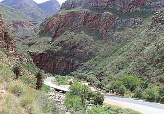
Meiringspoort is a South African mountain pass on the N12 national road, where it crosses the Swartberg mountain range.

The Molteno Formation is a geological formation found in several localities in Lesotho and South Africa. It lies mainly south of Maseru, near Burgersdorp, Aliwal North, Dordrecht, Molteno, and Elliot. It extends as far north as Matatiele in the Eastern Cape. The formation's localities lie along the Drakensberg Mountains in Kwazulu-Natal, and near Ladybrand in the Free State of South Africa. The Molteno Formation is the lowermost of the three formations in the Stormberg Group of the greater Karoo Supergroup. The Molteno Formation represents the initial phase of preserved sedimentation of the Stormberg Group.

Molteno is a town in the Eastern Cape province of South Africa.
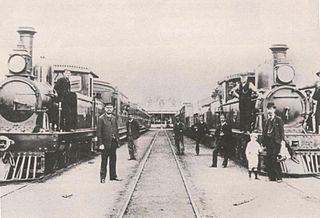
The Cape Government Railways (CGR) was the government-owned railway operator in the Cape Colony from 1874 until the creation of the South African Railways (SAR) in 1910.

The Stormberg Group is one of the four geological groups that comprises the Karoo Supergroup in South Africa. It is the uppermost geological group representing the final phase of preserved sedimentation of the Karoo Basin. The Stormberg Group rocks are considered to range between Lower Triassic (Olenekian) to Lower Jurassic (Pliensbachian) in age. These estimates are based on means of geological dating including stratigraphic position, lithostratigraphic and biostratigraphic correlations, and palynological analyses.

Touws River is a small railway town of 6,800 people in the Western Cape province of South Africa. It is located on the river of the same name, about 160 kilometres (100 mi) north-east of Cape Town. The Touwsrivier CPV Solar Project is located just outside of the town and supplies 50 MW to the national electrical grid.

Leeu-Gamka is a small town in the Western Cape province of South Africa, located 355 kilometres (221 mi) north-east of Cape Town in the Karoo.

The Three Sisters are a land formation near Victoria West, Northern Cape, South Africa, comprising three distinctively shaped hills. The farm on which they are situated and the nearby railway siding are also named Three Sisters.
People of the Karoo refers to notable individuals who come from, or whose lives have included substantial engagement with, the area known as the Karoo. The Karoo is a widespread physiographic province in the western interior of South Africa, straddling much of the Northern Cape, southern Free State, Eastern Cape interior and parts of the Western Cape Provinces.

Prince Albert Road is a village located in Laingsburg Local Municipality, Western Cape.


