
The San Francisco Peninsula is a peninsula in the San Francisco Bay Area that separates San Francisco Bay from the Pacific Ocean. On its northern tip is the City and County of San Francisco. Its southern base is in northern Santa Clara County, including the cities of Sunnyvale, Palo Alto, Mountain View, and Los Altos. Most of the Peninsula is occupied by San Mateo County, between San Francisco and Santa Clara counties, and including the cities and towns of Atherton, Belmont, Brisbane, Burlingame, Colma, Daly City, East Palo Alto, El Granada, Foster City, Hillsborough, Half Moon Bay, La Honda, Loma Mar, Los Altos, Menlo Park, Millbrae, Mountain View, Pacifica, Palo Alto, Pescadero, Portola Valley, Redwood City, San Bruno, San Carlos, San Mateo, South San Francisco, Sunnyvale, and Woodside.
Palo Alto is a charter city in the northwestern corner of Santa Clara County, California, United States, in the San Francisco Bay Area, named after a coastal redwood tree known as El Palo Alto.

East Palo Alto is a city in San Mateo County, California, United States. As of the 2020 census, the population of East Palo Alto was 30,034. It is situated on the San Francisco Peninsula, roughly halfway between the cities of San Francisco and San Jose. To the north and east is the San Francisco Bay, to the west is the city of Menlo Park, and to the south the city of Palo Alto. Despite being called "East" Palo Alto, the city is directly north of Palo Alto. While often incorrectly assumed to be part of the city of Palo Alto, East Palo Alto has always been a separate entity since its founding as an unincorporated community and its incorporation in July 1983. It is also in San Mateo County, while Palo Alto is in Santa Clara County. The two cities are separated only by San Francisquito Creek and, largely, the Bayshore Freeway. The revitalization projects in 2000, and high income high-tech professionals moving into new developments, including employees from Google and Facebook, have begun to eliminate the cultural and economic differences between the two cities. East Palo Alto and Palo Alto share both telephone area codes and postal ZIP codes.

Cupertino is a city in Santa Clara County, California, United States, directly west of San Jose on the western edge of the Santa Clara Valley with portions extending into the foothills of the Santa Cruz Mountains. The population was 57,820 as of the 2020 census. It is known for being the home of Apple Inc., headquartered at Apple Park.

Mountain View is a city in Santa Clara County, California, United States. Named for its views of the Santa Cruz Mountains, it has a population of 82,376.

The Ohlone, formerly known as Costanoans, are a Native American people of the Northern California coast. When Spanish explorers and missionaries arrived in the late 18th century, the Ohlone inhabited the area along the coast from San Francisco Bay through Monterey Bay to the lower Salinas Valley. At that time they spoke a variety of related languages. The Ohlone languages make up a sub-family of the Utian language family. Older proposals place Utian within the Penutian language phylum, while newer proposals group it as Yok-Utian.

Area code 650 is a telephone area code in the North American Numbering Plan (NANP) for the San Francisco Bay Area in the U.S. state of California. It was split from area code 415 on August 2, 1997, and includes most of San Mateo County, part of San Francisco, and the northwestern portion of Santa Clara County including Palo Alto, Mountain View, and Los Altos.

Hayes Valley is a neighborhood in the Western Addition district of San Francisco, California. It is located between the historical districts of Alamo Square and the Civic Center. Victorian, Queen Anne, and Edwardian townhouses are mixed with high-end boutiques, restaurants, and public housing complexes. The neighborhood gets its name from Hayes Street, which was named for Thomas Hayes, San Francisco's county clerk from 1853 to 1856 who also started the first Market Street Railway franchise.
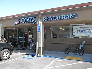
Hobee'sRestaurant is a chain of sit-down restaurants in San Mateo and Santa Clara counties in Northern California, founded in 1974 by Paul Taber.

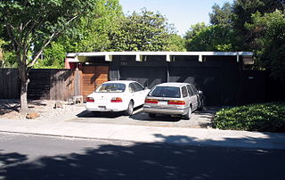
Joseph Leopold Eichler was a 20th-century post-war American real estate developer known for developing distinctive residential subdivisions of Mid-century modern style tract housing in California. He was one of the influential advocates of bringing modern architecture from custom residences and large corporate buildings to general public availability. His company and developments remain in the Greater San Francisco Bay Area and Greater Los Angeles.
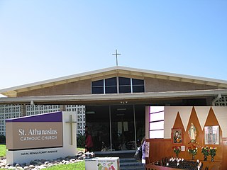
Saint Athanasius Parish is a territorial parish of the Roman Catholic Diocese of San Jose in California. The parish was established June 19, 1959, by John J. Mitty, D.D., Archbishop of San Francisco, to serve Catholics of Mountain View and Palo Alto. The parish is named for Athanasius, Patriarch of Alexandria.
One of the six Boy Scouts of America councils that serves the San Francisco Bay area, the Pacific Skyline Council was founded in 1940 as the Stanford Area Council (#031). In 1994, the Stanford Area Council merged with the San Mateo County Council (#020) to form the current council which serves youth in San Mateo County and northern Santa Clara county.
Santa Clara County, California, is one of California's original counties, with prior habitation dating from prehistory to the Alta California period.
Rancho Rincon de San Francisquito was a 8,418-acre (34.07 km2) Mexican land grant in present-day Santa Clara County, California given in 1841 by Governor Juan Alvarado to José Peña. The name means "corner or bend of the San Francisquito" referring to San Francisquito Creek. The grant extended along Matadero Creek to the hills and included the southern part of present-day Palo Alto and the southern part of the Stanford University campus.
Adobe Creek, historically San Antonio Creek, is a 14.2-mile-long (22.9 km) northward-flowing stream originating on Black Mountain in the Santa Cruz Mountains. It courses through the cities of Los Altos Hills, Los Altos, and Palo Alto on its way to the Palo Alto Flood Basin and thence to southwestern San Francisco Bay in Santa Clara County, California, United States. Historically, Adobe Creek was a perennial stream and hosted runs of steelhead trout entering from the Bay, but these salmonids are now blocked by numerous flood control structures, including a tidal gate at the creek's mouth and a long concretized rectangular channel culminating in an impassable drop structure at El Camino Real. The co-founders of Adobe Systems both lived on Adobe Creek.
Anshen and Allen was an international architecture, planning and design firm headquartered in San Francisco with offices in Boston, Columbus, and London. The firm was ranked eighth for sustainable practices, and nineteenth overall in the "Architect 50" published by Architect magazine in 2010. They also ranked twenty-eighth in the top "100 Giants" of Interior Design 2010.
Greenmeadow is a subdivision located in southern Palo Alto, California.
Mayfield Mall was a shopping mall in Mountain View, California, United States. Operational from 1966 to 1984, it was the first air-conditioned, enclosed shopping mall in Northern California, though it has been an office complex since the 1980s. In 2013, Google rented the entire 500,000 square feet (46,000 m2) property and ultimately purchased it in 2016 for $225 million; it is now known as the company's Building RLS1.
The following is a timeline of the history of the city of Mountain View, California, USA.
John Calder Mackay was an American post-war real estate developer, best known for his modernist tract homes built by the company he co-founded, Mackay Homes. He also served on the board of directors for the Children's Health Council and was one of the founders of the Palo Alto Medical Foundation.

