Montague, Michigan

Last updated
Montague, Michigan
Muskegon County Michigan Incorporated and Unincorporated areas Montague Highlighted.svg
Location within Muskegon County and the state of Michigan
Coordinates: 43°25′N86°21′W / 43.417°N 86.350°W / 43.417; -86.350
Country United States
State Michigan
County Muskegon
Government
   Mayor Tom Lohman
Area
[1]
  Total3.14 sq mi (8.14 km2)
  Land2.63 sq mi (6.81 km2)
  Water0.52 sq mi (1.33 km2)
Elevation
636 ft (194 m)
Population
 (2020) [2]
  Total2,417
  Density920.06/sq mi (355.17/km2)
Time zone UTC-5 (EST)
  Summer (DST) UTC-4 (EDT)
ZIP code
49437
Area code 231
FIPS code 26-55100 [3]
GNIS feature ID1620880 [4]
Website cityofmontague.org

Montague is a city in Muskegon County in the U.S. state of Michigan. The population was 2,417 at the 2020 census. [2] The city is politically independent from Montague Township, which borders it on three sides.

Contents

History and culture

Noah Ferry founded the city, naming it in honor of his father, William Montague Ferry, who founded the cities of Grand Haven and Ferrysburg in neighboring Ottawa County. Ferry Church, built in 1874, is named in honor of Noah Henry Ferry, who died fighting for the Union at the Battle of Gettysburg in 1863.

At one time, Ferry Street, also named for the founder, was the main street through town. It was named for him because the city's post office operated on that street following its establishment in 1867, and Ferry was instrumental in getting a post office in the city. Although city hall, the city's new post office (constructed in 2005), and a handful of businesses still operate on Ferry, Dowling Street has become the city's main route because of its eventual connection to neighboring communities and U.S. Highway 31.

Montague is home to the "World's Largest Working Weathervane", which was constructed in part by local manufacturer Whitehall Metal Studios. The weathervane is topped by the Ella Ellenwood , a lumbering schooner that frequented White Lake transporting lumber from Montague to Milwaukee, Wisconsin. The ship became infamous after it sank in a storm in 1901, and the wooden nameplate of the schooner floated back to the shores of Montague, where it was found in 1902. Many people believed that the boat was coming home, and as a result the ship is frequently associated with the city.[ citation needed ]

Geography

Montague is in northwestern Muskegon County, bordered to the west, north, and northeast by Montague Township and to the southeast by the city of Whitehall. The upstream end of White Lake, a water body connected to Lake Michigan, separates the two cities. Montague is 16 miles (26 km) north of Muskegon, the county seat.

According to the U.S. Census Bureau, the city of Montague has a total area of 3.14 square miles (8.13 km2), of which 2.63 square miles (6.81 km2) are land and 0.52 square miles (1.35 km2), or 16.4%, are water. [1]

The Montague ZIP code 49437 serves all of Montague city, Montague Township and White River Township, as well as small portions of Whitehall Township and Blue Lake Township in Muskegon County and parts of Claybanks Township and Grant Township in Oceana County. [5]

The city is at the southern end of the Hart-Montague Trail, a paved cycling and multiuse trail which attracts visitors during the warm months to Montague, Hart, and the small towns and businesses in between.

Major highways

Demographics

Historical population
CensusPop.Note
1880 1,297
1890 1,62325.1%
1900 998−38.5%
1910 942−5.6%
1920 845−10.3%
1930 8875.0%
1940 1,09923.9%
1950 1,53039.2%
1960 2,36654.6%
1970 2,3961.3%
1980 2,332−2.7%
1990 2,276−2.4%
2000 2,4075.8%
2010 2,361−1.9%
2020 2,4172.4%
U.S. Decennial Census [6]

2010 census

As of the census [7] of 2010, there were 2,361 people, 1,006 households, and 643 families residing in the city. The population density was 922.3 inhabitants per square mile (356.1/km2). There were 1,182 housing units at an average density of 461.7 per square mile (178.3/km2). The racial makeup of the city was 96.0% White, 0.6% African American, 1.0% Native American, 0.3% Asian, 0.4% from other races, and 1.6% from two or more races. Hispanic or Latino of any race were 3.4% of the population.

There were 1,006 households, of which 31.9% had children under the age of 18 living with them, 46.9% were married couples living together, 13.1% had a female householder with no husband present, 3.9% had a male householder with no wife present, and 36.1% were non-families. 30.8% of all households were made up of individuals, and 14.5% had someone living alone who was 65 years of age or older. The average household size was 2.35 and the average family size was 2.93.

The median age in the city was 39.9 years. 25.2% of residents were under the age of 18; 7.4% were between the ages of 18 and 24; 23.2% were from 25 to 44; 28.1% were from 45 to 64; and 16.1% were 65 years of age or older. The gender makeup of the city was 46.0% male and 54.0% female.

2000 census

As of the census [3] of 2000, there were 2,407 people, 990 households, and 667 families residing in the city. The population density was 905.1 inhabitants per square mile (349.5/km2). There were 1,075 housing units at an average density of 404.3 per square mile (156.1/km2). The racial makeup of the city was 97.17% White, 0.37% African American, 0.46% Native American, 0.25% Asian, 0.00% Pacific Islander, 0.58% from other races, and 1.16% from two or more races. 2.33% of the population were Hispanic or Latino of any race.

There were 990 households, out of which 32.1% had children under the age of 18 living with them, 51.5% were married couples living together, 12.5% had a female householder with no husband present, and 32.6% were non-families. 28.3% of all households were made up of individuals, and 11.7% had someone living alone who was 65 years of age or older. The average household size was 2.43 and the average family size was 2.97.

In the city, the population was spread out, with 26.1% under the age of 18, 8.8% from 18 to 24, 27.0% from 25 to 44, 23.7% from 45 to 64, and 14.4% who were 65 years of age or older. The median age was 37 years. For every 100 females, there were 89.8 males. For every 100 females age 18 and over, there were 87.2 males.

The median income for a household in the city was $40,677, and the median income for a family was $49,185. Males had a median income of $37,389 versus $25,282 for females. The per capita income for the city was $21,238. 9.5% of the population and 6.6% of families were below the poverty line. Out of the total population, 9.1% of those under the age of 18 and 9.3% of those 65 and older were living below the poverty line.

Schools

Montague Area Public Schools (MAPS) is the local school district for the city of Montague. Three of the district's five schools are located in the city, Montague High School, Nellie B. Chisholm (NBC) Middle School and R.R. Oehrli (RRO) Elementary School. The district's other two schools, Oceana High School and Rothbury Elementary are located in the Village of Rothbury. The district serves students of both Muskegon and Oceana counties. This arrangement exists after voters living in the district of Rothbury Public Schools agreed to merge with the district of Montague Public Schools. This merger of the two districts took place in the 1950s to increase efficiency and decrease costs for both communities, led to the formation of "Montague Area Public Schools".

The district serves students living in the Muskegon County communities of the city of Montague, as well as Montague and White River townships. In addition it serves students living in parts of Whitehall and Blue Lake townships. The district also serves students living in the Oceana County communities of the Village of Rothbury and Otto Township. It also serves students living in parts of New Era. Also, the district is a member of the "Muskegon County School of Choice" program; the district can serve anyone living in Muskegon County. The district has increased enrollment slightly from the program, but has limited growth in the past because the rural district has limited capacity for new enrollees.

The city of Montague is also the home of Saint James Catholic School. The small parochial school serves grades K-5 and has roughly 100 students. It serves students living in the Montague Area Public School District, as well as the Whitehall District Schools. The school shares busing with both districts, and dropped the sixth grade a few years after adding kindergarten. Recently[ when? ], White Lake Baptist Academy (grades K-12) and Mouth School (grades K-8) closed because of dwindling enrollment.

Notable people

Climate

This climatic region is typified by large seasonal temperature differences, with warm to hot (and often humid) summers and cold (sometimes severely cold) winters. According to the Köppen Climate Classification system, Montague has a humid continental climate, abbreviated "Dfb" on climate maps. [9]

Climate data for Montague 4 NW, Michigan (1991–2020 normals, extremes 1893–present)
MonthJanFebMarAprMayJunJulAugSepOctNovDecYear
Record high °F (°C)59
(15)
65
(18)
80
(27)
84
(29)
94
(34)
98
(37)
96
(36)
97
(36)
96
(36)
85
(29)
74
(23)
64
(18)
98
(37)
Mean maximum °F (°C)48.2
(9.0)
49.1
(9.5)
62.8
(17.1)
73.5
(23.1)
81.9
(27.7)
87.0
(30.6)
87.4
(30.8)
86.3
(30.2)
84.2
(29.0)
74.6
(23.7)
61.5
(16.4)
50.7
(10.4)
89.3
(31.8)
Mean daily maximum °F (°C)30.2
(−1.0)
32.4
(0.2)
42.1
(5.6)
55.2
(12.9)
66.6
(19.2)
75.3
(24.1)
79.3
(26.3)
77.9
(25.5)
71.6
(22.0)
58.5
(14.7)
45.4
(7.4)
34.9
(1.6)
55.8
(13.2)
Daily mean °F (°C)24.4
(−4.2)
25.6
(−3.6)
33.6
(0.9)
44.7
(7.1)
55.1
(12.8)
64.4
(18.0)
68.7
(20.4)
67.6
(19.8)
61.2
(16.2)
50.0
(10.0)
38.9
(3.8)
29.7
(−1.3)
47.0
(8.3)
Mean daily minimum °F (°C)18.6
(−7.4)
18.8
(−7.3)
25.0
(−3.9)
34.2
(1.2)
43.6
(6.4)
53.4
(11.9)
58.0
(14.4)
57.2
(14.0)
50.7
(10.4)
41.4
(5.2)
32.3
(0.2)
24.5
(−4.2)
38.1
(3.4)
Mean minimum °F (°C)−3.6
(−19.8)
−1.9
(−18.8)
5.0
(−15.0)
17.7
(−7.9)
28.0
(−2.2)
36.7
(2.6)
43.9
(6.6)
43.3
(6.3)
33.5
(0.8)
24.4
(−4.2)
18.2
(−7.7)
6.6
(−14.1)
−7.7
(−22.1)
Record low °F (°C)−21
(−29)
−27
(−33)
−17
(−27)
−8
(−22)
18
(−8)
23
(−5)
32
(0)
32
(0)
24
(−4)
14
(−10)
−14
(−26)
−15
(−26)
−27
(−33)
Average precipitation inches (mm)2.60
(66)
1.37
(35)
2.28
(58)
3.84
(98)
3.35
(85)
3.32
(84)
2.98
(76)
3.29
(84)
3.18
(81)
4.06
(103)
3.15
(80)
1.77
(45)
35.19
(894)
Average snowfall inches (cm)26.0
(66)
13.8
(35)
6.7
(17)
1.7
(4.3)
0.0
(0.0)
0.0
(0.0)
0.0
(0.0)
0.0
(0.0)
0.0
(0.0)
0.1
(0.25)
4.7
(12)
15.9
(40)
68.9
(175)
Average extreme snow depth inches (cm)12.8
(33)
12.0
(30)
7.1
(18)
0.9
(2.3)
0.0
(0.0)
0.0
(0.0)
0.0
(0.0)
0.0
(0.0)
0.0
(0.0)
0.0
(0.0)
2.5
(6.4)
7.9
(20)
15.3
(39)
Average precipitation days (≥ 0.01 in)9.67.08.210.110.89.48.08.29.210.910.18.7110.2
Average snowy days (≥ 0.1 in)10.86.22.80.80.00.00.00.00.00.12.47.330.4
Source: NOAA [10] [11]

Related Research Articles

<span class="mw-page-title-main">Oceana County, Michigan</span> County in Michigan, United States

Oceana County is a county located in the U.S. state of Michigan. As of the 2020 Census, the population was 26,659. The county seat is Hart. Long known as part of the large Ojibwe territory, the county was founded by European Americans in 1840 and organized in 1855.

<span class="mw-page-title-main">Newaygo County, Michigan</span> County in Michigan, United States

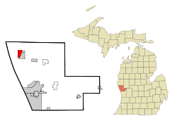
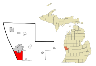
Newaygo County is a county in the U.S. state of Michigan. As of the 2020 United States Census, the population was 49,978. The county seat is White Cloud. The county was created in 1840, and was organized in 1851. It was either named for an Ojibwe leader who signed the Treaty of Saginaw in 1819 or for an Algonquian word meaning "much water".

<span class="mw-page-title-main">Muskegon County, Michigan</span> County in Michigan, United States

Muskegon County is a county in the U.S. state of Michigan. As of 2020, the population was 175,824. The county seat is Muskegon.

<span class="mw-page-title-main">Mason County, Michigan</span> County in Michigan, United States

Mason County is a county located in the U.S. state of Michigan. As of the 2020 Census, the population was 29,052. The county seat is Ludington.

<span class="mw-page-title-main">Kent City, Michigan</span> Village in Michigan, United States

Kent City is a village in Kent County in the U.S. state of Michigan. The population was 1,262 at the 2020 census. The village is located within Tyrone Township.

<span class="mw-page-title-main">Summit Township, Mason County, Michigan</span> Civil township in Michigan, United States

Summit Township is a civil township of Mason County in the U.S. state of Michigan. The population was 995 at the 2020 census.

<span class="mw-page-title-main">Lakeview, Michigan</span> Village in Michigan, United States

Lakeview is a village in Cato Township in Montcalm County of the U.S. state of Michigan. The population was 1,024 at the 2020 census.

Reynolds Township is a civil township of Montcalm County in the U.S. state of Michigan. The population was 5,431 at the 2020 census.

Holton Township is a civil township of Muskegon County in the U.S. state of Michigan. As of the 2000 census, the township population was 2,532.

Montague Township is a civil township of Muskegon County in the U.S. state of Michigan. The population was 1,637 at the 2000 census. The city of Montague is located within the township, on the shores of White Lake.

Muskegon Charter Township is a charter township of Muskegon County in the U.S. state of Michigan. The population was 17,737 at the 2000 census. The City of Muskegon is at the southwest corner of the township and is administratively autonomous. The township shares all five of the city's zip codes.

<span class="mw-page-title-main">Norton Shores, Michigan</span> City in Michigan, United States

Norton Shores is a city in Muskegon County in the U.S. state of Michigan. The population was 25,030 at the 2020 census.

<span class="mw-page-title-main">Whitehall, Michigan</span> City in Michigan, United States

Whitehall is a city in Muskegon County in the U.S. state of Michigan. The population was 2,706 at the 2010 census. The city is located in the southwest corner of Whitehall Township. Montague is its neighbor.

Whitehall Township is a civil township of Muskegon County in the U.S. state of Michigan. The population was 1,648 at the 2000 census. The city of Whitehall is located at the southwest corner of the township, but is administratively autonomous.

Claybanks Township is a civil township of Oceana County in the U.S. state of Michigan. The population was 855 at the 2020 census.

Ferry Township is a civil township of Oceana County in the U.S. state of Michigan. The population was 1,296 at the 2000 census.

<span class="mw-page-title-main">Hart, Michigan</span> City in Michigan, United States

Hart is a city and county seat of Oceana County, Michigan. The population was 2,126 at the time of the 2010 census. The city is located within Hart Township, but is politically independent.

Chester Township is a civil township of Ottawa County in the U.S. state of Michigan. As of the 2000 United States Census, the township population was 2,315.

<span class="mw-page-title-main">Ferrysburg, Michigan</span> City in Michigan, United States

Ferrysburg is a city in Ottawa County in the U.S. state of Michigan. The population was 2,892 at the 2010 census.

<span class="mw-page-title-main">North Whitehall Township, Pennsylvania</span> Township in Pennsylvania, United States

North Whitehall Township is a township in Lehigh County, Pennsylvania. The population of North Whitehall Township was 15,655 at the 2020 census. It is a suburb of Allentown in the Lehigh Valley, which had a population of 861,899 and was the 68th-most populous metropolitan area in the U.S. as of the 2020 census.

References

  1. 1 2 "2023 U.S. Gazetteer Files: Michigan". United States Census Bureau. Retrieved December 13, 2023.
  2. 1 2 "P1. Race – Montague city, Michigan: 2020 DEC Redistricting Data (PL 94-171)". U.S. Census Bureau. Retrieved December 13, 2023.
  3. 1 2 "U.S. Census website". United States Census Bureau . Retrieved 2008-01-31.
  4. U.S. Geological Survey Geographic Names Information System: Montague, Michigan
  5. 49437 5-Digit ZCTA, 494 3-Digit ZCTA - Reference Map - American FactFinder [ permanent dead link ], U.S. Census Bureau, 2000 census
  6. "Census of Population and Housing". Census.gov. Retrieved June 4, 2015.
  7. "U.S. Census website". United States Census Bureau . Retrieved 2012-11-25.
  8. Graves, William S. (1940). "Death Notice, Joseph Dugald Leitch". Seventy-first Annual Report of the Association of Graduates of the United States Military Academy. Newburgh, NY: Moore Printing Company. p. 185 via West Point Digital Library.
  9. Climate Summary for Montague, Michigan
  10. "NowData – NOAA Online Weather Data". National Oceanic and Atmospheric Administration. Retrieved September 4, 2021.
  11. "Station: Montague 4 NW, MI". U.S. Climate Normals 2020: U.S. Monthly Climate Normals (1991–2020). National Oceanic and Atmospheric Administration. Retrieved September 4, 2021.

43°25′N86°21′W / 43.417°N 86.350°W / 43.417; -86.350