Pretoria, also known as Tshwane, is South Africa's administrative capital, serving as the seat of the executive branch of government, and as the host to all foreign embassies to South Africa.

Sandton is a financial, commercial and residential area, located in the northern part of the City of Johannesburg Metropolitan Municipality. Formerly an independent municipality, Sandton's name came from the combination of two of its suburbs, Sandown and Bryanston.

Noble Park is a suburb in Melbourne, Victoria, Australia, 25 km south-east of Melbourne's Central Business District, located within the City of Greater Dandenong local government area. Noble Park recorded a population of 32,257 at the 2021 census.

Randburg is an area located in the Gauteng province of South Africa. Formerly a separate municipality, its administration devolved to the newly created City of Johannesburg Metropolitan Municipality, along with neighbouring Sandton and Roodepoort, in the late 1990s. During the transitional period of 1996–2000, Randburg was part of the Northern Metropolitan Local Council (MLC).
The area referred to as Fourways is the fastest-developing commercial and residential hub in Sandton, north of Johannesburg, South Africa. The main access routes to Fourways are off the N1 at R511 Winnie Mandela Drive, or alternatively along R564 Witkoppen Road. It is located mostly in Region E of the City of Johannesburg Metropolitan Municipality. It is roughly as far as one can go in the Johannesburg Metropolitan area before it dissolves into rolling hills, game farms and the capital Pretoria, 55 kilometres to the northeast. Hartebeespoort Dam and the Magaliesberg Mountains lie half an hour to the north-west. It is bordered by Bryanston to the east and south and Randburg to the west.

Bryanston is an affluent residential suburb of Sandton, Gauteng, South Africa to the north of Johannesburg. First named as an area in 1949, it was established in 1969 as a suburb of Sandton and provided with tarred roads and municipal services, but after municipal boundaries were revised following the end of Apartheid, Sandton was merged with Johannesburg to form part of the City of Johannesburg Metropolitan Municipality. The multi-lane N1 freeway forms its northern boundary with access at the R511/M81 off-ramp. It is located in Region E of the City of Johannesburg Metropolitan Municipality.

Middelburg is a large farming and industrial town in the South African province of Mpumalanga.

The R23 is a provincial route in South Africa that links Benoni with Volksrust via Brakpan, Heidelberg and Standerton.

The R55 is a north-south provincial route in Gauteng, South Africa that connects Sandton with Pretoria. It passes Woodmead, Kyalami, Olievenhoutbosch, Heuweloord, Sunderland Ridge, Erasmia, Laudium/Claudius, West Park, the Daspoort Tunnel and Danville. It connects with the M1, N14, and R80 highways. It is also designated as the P66-1 and K71 by the Gauteng Provincial Government.

Groenkloof is a residential suburb of Pretoria, South Africa.
Ga-Rankuwa is a large settlement located about 37 km north-west of Pretoria. Provincially it is in Gauteng province, but it used to fall in Bophuthatswana during the apartheid years, and under the North West province until the early 2000s.
Randpark Ridge is an upmarket suburb of Randburg, South Africa. It is located in Region C of the City of Johannesburg. It fell into the town of Randburg during the apartheid era. Developed in the early 1980s and still relatively new, Randpark Ridge is bordered by several other suburbs including Weltevreden Park, Sundowner, Boskruin, Bromhof, Honeydew and Fairland.
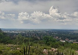
Akasia is a complex of suburbs north of Pretoria, part of the City of Tshwane Metropolitan Municipality. Formerly an independent municipality, the area surrounding Akasia is largely semi-rural and Akasia itself is built on former agricultural holdings.

Pretoria North is a suburb of the city of Pretoria, Gauteng, South Africa, with a population of 16,972 people according to the 2011 census.
The R513 is a Regional Route in South Africa that connects Hartbeespoort with Bronkhorstspruit via Akasia, Pretoria North and Cullinan.
Garsfontein is a residential suburb of the city of Pretoria in the Gauteng province of South Africa. It is a well-developed area, lying to the east of the city centre, close to the Menlyn Park shopping center.
Pro Arte Alphen Park is a government school specialising in the creative and performing arts situated in the suburb of Alphen Park in Pretoria in Gauteng province of South Africa. It also has boarding facilities, It is produces good academic results every year.
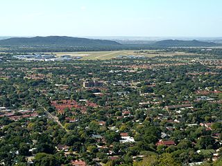
Sinoville is a northern suburb of Pretoria, South Africa. It lies to the east of the Wonderboom, on the northern slopes of the Magaliesberg mountains, and south of Wonderboom Airport.
The M6 road is a long metropolitan route in the City of Tshwane in Gauteng, South Africa. It connects Pretoria West with a rural area east of Pretoria via Pretoria CBD, Brooklyn, Lynnwood and Wapadrand.
The M29 road is a metropolitan route in the City of Tshwane in Gauteng, South Africa. It is made up of two disjoint segments in the northern suburbs of Pretoria, with one section connecting Rietondale to Waverley and the other section connecting Montana Park to Doornpoort.