Morristown, South Dakota

Last updated

Morristown, South Dakota
Corson County South Dakota Incorporated and Unincorporated areas Morristown Highlighted.svg
Location in Corson County and the state of South Dakota
Coordinates: 45°56′19″N101°43′08″W / 45.93861°N 101.71889°W / 45.93861; -101.71889
Country United States
State South Dakota
County Corson
Incorporated1910 [1]
Area
[2]
  Total0.35 sq mi (0.91 km2)
  Land0.35 sq mi (0.91 km2)
  Water0.00 sq mi (0.00 km2)
Elevation
[3]
2,251 ft (686 m)
Population
 (2020) [4]
  Total47
  Density133.90/sq mi (51.73/km2)
Time zone UTC-7 (Mountain (MST))
  Summer (DST) UTC-6 (MDT)
ZIP code
57645
Area code 605
FIPS code 46-43860 [5]
GNIS feature ID1267484 [3]

Morristown is a town in Corson County, South Dakota, United States. The population was 67 at the 2010 census.

Contents

History

Morristown got its start in 1907 when the railroad was extended to that point. [6] The town was named for Nelson Morris, founder of Morris and Company. [6]

Geography

According to the United States Census Bureau, the town has a total area of 0.35 square miles (0.91 km2), all land. [7]

Demographics

Historical population
CensusPop.Note
1910 222
1920 26921.2%
1930 268−0.4%
1940 217−19.0%
1950 190−12.4%
1960 21915.3%
1970 144−34.2%
1980 127−11.8%
1990 64−49.6%
2000 8228.1%
2010 67−18.3%
2020 47−29.9%
U.S. Decennial Census [8] [4]

2010 census

As of the census [9] of 2010, there were 67 people, 32 households, and 18 families residing in the town. The population density was 191.4 inhabitants per square mile (73.9/km2). There were 42 housing units at an average density of 120.0 per square mile (46.3/km2). The racial makeup of the town was 95.5% White and 4.5% Native American.

There were 32 households, of which 31.3% had children under the age of 18 living with them, 40.6% were married couples living together, 6.3% had a female householder with no husband present, 9.4% had a male householder with no wife present, and 43.8% were non-families. 43.8% of all households were made up of individuals, and 18.8% had someone living alone who was 65 years of age or older. The average household size was 2.09 and the average family size was 2.83.

The median age in the town was 37.5 years. 26.9% of residents were under the age of 18; 3% were between the ages of 18 and 24; 26.9% were from 25 to 44; 24% were from 45 to 64; and 19.4% were 65 years of age or older. The gender makeup of the town was 55.2% male and 44.8% female.

2000 census

As of the census [5] of 2000, there were 82 people, 32 households, and 24 families residing in the town. The population density was 242.8 inhabitants per square mile (93.7/km2). There were 44 housing units at an average density of 130.3 per square mile (50.3/km2). The racial makeup of the town was 90.24% White, 3.66% Native American, and 6.10% from two or more races. Hispanic or Latino of any race were 1.22% of the population.

There were 32 households, out of which 28.1% had children under the age of 18 living with them, 65.6% were married couples living together, 9.4% had a female householder with no husband present, and 25.0% were non-families. 15.6% of all households were made up of individuals, and 9.4% had someone living alone who was 65 years of age or older. The average household size was 2.56 and the average family size was 2.79.

In the town, the population was spread out, with 26.8% under the age of 18, 9.8% from 18 to 24, 22.0% from 25 to 44, 15.9% from 45 to 64, and 25.6% who were 65 years of age or older. The median age was 36 years. For every 100 females, there were 127.8 males. For every 100 females age 18 and over, there were 122.2 males.

The median income for a household in the town was $20,000, and the median income for a family was $21,875. Males had a median income of $17,083 versus $20,000 for females. The per capita income for the town was $12,017. There were no families and 2.5% of the population living below the poverty line, including no under eighteens and none of those over 64.

Related Research Articles

<span class="mw-page-title-main">Morristown, Indiana</span> Town in Indiana, United States

Morristown is a town in Hanover Township, Shelby County, in the U.S. state of Indiana. The population was 1,218 at the 2010 census.

<span class="mw-page-title-main">Morristown, Minnesota</span> City in Minnesota, United States

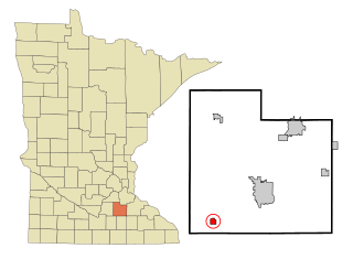
Morristown is a city in Rice County, Minnesota, United States. The population was 949 at the 2020 census.

<span class="mw-page-title-main">Morristown, Ohio</span> Village in Ohio, United States

Morristown is a village in Belmont County, Ohio, United States. The population was 248 at the 2020 census. It is part of the Wheeling metropolitan area.

<span class="mw-page-title-main">Claremont, South Dakota</span> Town in South Dakota, United States

Claremont is a town in Brown County, South Dakota, United States. The population was 108 at the 2020 census.

<span class="mw-page-title-main">Warner, South Dakota</span> Town in South Dakota, United States

Warner is a town in Brown County, South Dakota, United States. The population was 485 at the 2020 census.

<span class="mw-page-title-main">Westport, South Dakota</span> Town in South Dakota, United States

Westport is a town in western Brown County, South Dakota, United States. The population was 88 at the 2020 census.

<span class="mw-page-title-main">Ravinia, South Dakota</span> Town in South Dakota, United States

Ravinia is a town in Charles Mix County, South Dakota, United States. The population was 71 at the 2020 census.

<span class="mw-page-title-main">Bradley, South Dakota</span> Town in South Dakota, United States

Bradley is a town in Clark County, South Dakota, United States. The population was 65 at the 2020 census.

<span class="mw-page-title-main">Willow Lake, South Dakota</span> City in South Dakota, United States

Willow Lake is a city in Clark County, South Dakota, United States. The population was 255 at the 2020 census.

<span class="mw-page-title-main">Florence, South Dakota</span> Town in South Dakota, United States

Florence is a town in northwestern Codington County, South Dakota, United States. It is part of the Watertown, South Dakota Micropolitan Statistical Area. The population was 337 at the 2020 census.

<span class="mw-page-title-main">South Shore, South Dakota</span> Town in South Dakota, United States

South Shore is a town in Codington County, South Dakota, United States. The population was 189 at the 2020 census. It is part of the Watertown, South Dakota Micropolitan Statistical Area.

<span class="mw-page-title-main">Fairburn, South Dakota</span> Town in South Dakota, United States

Fairburn is a town in Custer County, South Dakota, United States. The population was 60 at the 2020 census.

<span class="mw-page-title-main">Ethan, South Dakota</span> Town in South Dakota, United States

Ethan is a town in Davison County, South Dakota, United States. It is part of the Mitchell, South Dakota Micropolitan Statistical Area. The population was 365 at the 2020 census. Ethan is located 10 miles south of Mitchell.

<span class="mw-page-title-main">Astoria, South Dakota</span> Town in South Dakota, United States

Astoria is a town in Deuel County, South Dakota, United States. The population was 132 at the 2020 census.

<span class="mw-page-title-main">Hudson, South Dakota</span> Town in South Dakota, United States

Hudson is a town in Lincoln County, South Dakota, United States. The population was 311 at the 2020 census. It is the easternmost community in South Dakota.

<span class="mw-page-title-main">Crooks, South Dakota</span> City in South Dakota, United States

Crooks is a city in Minnehaha County, South Dakota, United States and is a suburb of Sioux Falls. The population was 1,362 at the 2020 census. Crooks was named New Hope until 1904. The town's present name honors W. A. Crooks, a local politician.

<span class="mw-page-title-main">Peever, South Dakota</span> Town in South Dakota, United States

Peever is a town in Roberts County, South Dakota, United States. The population was 180 at the 2020 census.

<span class="mw-page-title-main">Tulare, South Dakota</span> Town in South Dakota, United States

Tulare is a town in Spink County, South Dakota, United States. The population was 211 at the 2020 census.

<span class="mw-page-title-main">Tower City, North Dakota</span> City in North Dakota, United States

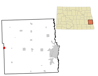
Tower City is a city in Barnes and Cass counties in the State of North Dakota. The population was 268 at the 2020 census.

<span class="mw-page-title-main">Sarles, North Dakota</span> City in North Dakota, United States

Sarles is a city in Cavalier and Towner counties in the State of North Dakota. The population was 16 at the 2020 census. Sarles was founded in 1905 at the end of the Great Northern railway extension north of Munich, called the "Sarles Branch". The town is named for North Dakota Governor Elmore Y. Sarles.

References

  1. "SD Towns" (PDF). South Dakota State Historical Society . Retrieved February 14, 2010.
  2. "ArcGIS REST Services Directory". United States Census Bureau. Retrieved October 15, 2022.
  3. 1 2 U.S. Geological Survey Geographic Names Information System: Morristown, South Dakota
  4. 1 2 "Census Population API". United States Census Bureau. Retrieved October 15, 2022.
  5. 1 2 "U.S. Census website". United States Census Bureau . Retrieved January 31, 2008.
  6. 1 2 Federal Writers' Project (1940). South Dakota place-names, v.1-3. University of South Dakota. p. 52.
  7. "US Gazetteer files 2010". United States Census Bureau. Archived from the original on January 25, 2012. Retrieved June 21, 2012.
  8. "Census of Population and Housing". Census.gov. Retrieved June 4, 2015.
  9. "U.S. Census website". United States Census Bureau . Retrieved June 21, 2012.