
KwaZulu-Natal is a province of South Africa that was created in 1994 when the Zulu bantustan of KwaZulu and Natal Province were merged. It is located in the southeast of the country, with a long shoreline on the Indian Ocean and sharing borders with three other provinces and the countries of Mozambique, Eswatini and Lesotho. Its capital is Pietermaritzburg, and its largest city is Durban. It is the second-most populous province in South Africa, with slightly fewer residents than Gauteng.
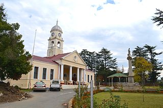
Kokstad is a town in the Harry Gwala District Municipality of KwaZulu-Natal Province, South Africa. Kokstad is named after the Griqua chief Adam Kok III who settled here in 1863. Kokstad is the capital town of the East Griqualand region, as it is also the biggest town in this region. It was built around Mount Currie, a local mountain range, by the city's founder Adam Kok III, for whom the town is named. Stad is the Dutch and Afrikaans word for "city".
KwaDukuza, previously known as Stanger, is a city in KwaZulu-Natal, South Africa. In 2006, the municipal name was changed to KwaDukuza, but the Zulu people in the area called it "Dukuza" well before then.

Matatiele is a town located in the northern part of the Eastern Cape Province of South Africa. According to the South African National Census of 2011, its 12,466 residents and 4,107 households make Matatiele the largest populated town in the Matatiele Local Municipality.
Hilton is a small town that lies between Howick and Pietemaritzburg in the province of KwaZulu-Natal, South Africa. In 1872 the Reverend William Orde Newnham opened Hilton College on a large estate 7.8km north of the town, which is now one of South Africa's leading private schools.

Verulam is a town 24 kilometres north of Durban in KwaZulu-Natal, South Africa and forms part of the eThekwini Metropolitan Municipality, governing the Greater Durban metropolitan area.

Umlazi is a township in KwaZulu-Natal, South Africa, located south-west of Durban. Organisationally and administratively it forms part of the eThekwini Metropolitan Municipality and its South Municipal Planning Region.

The N2 is a national route in South Africa that runs from Cape Town through George, Gqeberha, East London, Mthatha, Port Shepstone and Durban to Ermelo. It is the main highway along the Indian Ocean coast of the country. Its current length of 2,255 kilometres (1,401 mi) makes it the longest numbered route in South Africa.
The term taxi war refer to the turf wars fought between taxi associations and individual minibus taxi drivers in South Africa from the late 1980s onwards to the present.
Cedarville is a town in the Alfred Nzo District Municipality of Eastern Cape, South Africa.

Matatiele Municipality is a local municipality within the Alfred Nzo District Municipality, in the Eastern Cape province of South Africa. It adjoins Lesotho to the north, Elundini to the south-west, and Greater Kokstad to the east and its 4,352 km² makes the Matatiele Municipality largest of four municipalities in the district at almost half of its geographical area. According to the South African National Census of 2011, its 203,483 residents and 49,527 households makes Matatiele Municipality the second largest populated area in the Alfred Nzo District Municipality behind Mbizana.

Mtwalume, also known as Umtalumi, is a settlement in Ugu District Municipality in the KwaZulu-Natal province of South Africa.
The Mount Ayliff Christmas Day Massacre, also known as the Mount Ayliff Killings, was a mass shooting which occurred on the morning of 25 December 2020. It took place in the village of Mount Ayliff in the Eastern Cape province of South Africa and resulted in the death of between seven and nine people. At least six people were reported injured in the attack. It was reported that most of the dead were from the nearby village of Nokhatshile.
KwaDabeka is a township in KwaZulu-Natal, South Africa, located north-west of Durban and means "at the Dabeka location".

The 2021 South African unrest, also known as the July 2021 riots, the Zuma unrest or Zuma riots, was a wave of civil unrest that occurred in South Africa's KwaZulu-Natal and Gauteng provinces from 9 to 18 July 2021, sparked by the imprisonment of former President Jacob Zuma for contempt of court. Resulting protests against the incarceration triggered wider rioting and looting, much of it said to be undertaken by people not in support of Zuma and fuelled by job layoffs and economic inequality worsened by the COVID-19 pandemic policies. The unrest began in the province of KwaZulu-Natal on the evening of 9 July, and spread to the province of Gauteng on the evening of 11 July, and was the worst violence that South Africa had experienced since the end of Apartheid.
Jabulile Cynthia Nightingale Mkhwanazi is a South African African National Congress politician serving as a Member of the National Assembly of South Africa from KwaZulu-Natal since 2019.
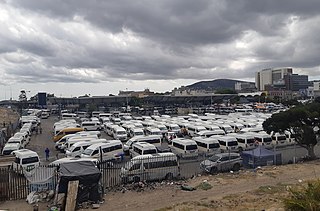
The 2021 Cape Town taxi conflict was a violent turf war between the minibus taxi operators Cape Amalgamated Taxi Association (CATA) and Congress of Democratic Taxi Association (CODETA) over lucrative taxi routes in Cape Town, South Africa. The conflict was part of a long running series of conflicts that are part of the ongoing taxi wars in South Africa.
Thembeka Vuyisile Buyisile Mchunu is a South African politician from KwaZulu-Natal serving as a Member of the National Assembly of South Africa since 2019. A member of the African National Congress, she served as the Executive Mayor of the Uthungulu District Municipality from 2011 to 2016. She is married to Senzo Mchunu, the current Minister of Water and Sanitation and the former premier of KwaZulu-Natal.

Amandawe also known as Amandawe Mission, or often informally abbreviated as A.M.A or A.M is a small township in the KwaZulu-Natal South Coast region of South Africa. The area is mostly populated with Black Africans.
Ndodephethe Bethuel Mthethwa is a South African politician who has represented the African National Congress (ANC) in the KwaZulu-Natal Provincial Legislature since 2019. He was formerly the Mayor of Jozini Local Municipality.


