Dallas Peak is a high mountain summit in the Sneffels Range of the Rocky Mountains of North America. The 13,815-foot (4,211 m) thirteener is located in the Mount Sneffels Wilderness of Uncompahgre National Forest, 3.3 miles (5.3 km) north by west of the Town of Telluride, Colorado, United States, on the drainage divide between Ouray and San Miguel counties.

Gilpin Peak is a high mountain summit in the Sneffels Range of the Rocky Mountains of North America. The 13,700-foot (4,176 m) thirteener is located in the Mount Sneffels Wilderness of Uncompahgre National Forest, 3.5 miles (5.6 km) north-northeast of the Town of Telluride, Colorado, United States, on the drainage divide between Ouray County and San Miguel County. Gilpin Peak was named in honor of William Gilpin, the first Governor of the Territory of Colorado.

Mount Garfield is a 13,074-foot-elevation (3,985-meter) mountain summit located in San Juan County, Colorado, United States. It is situated eight miles south of the community of Silverton, in the Weminuche Wilderness, on land managed by San Juan National Forest. It is part of the San Juan Mountains range which is a subset of the Rocky Mountains of North America. Precipitation runoff from the mountain drains into tributaries of the Animas River. The peak can be seen from U.S. Route 550 and the Durango and Silverton Narrow Gauge Railroad. Topographic relief is significant as the west aspect rises over 4,300 feet above the river and railway in approximately one mile. It is set six miles west of the Continental Divide, one mile west of Electric Peak, and three miles east-southeast of Snowdon Peak.

Mears Peak is a 13,496-foot-elevation (4,114-meter) mountain summit located on the common boundary of Ouray County with San Miguel County, in Colorado, United States. It is situated six miles northwest of the community of Telluride, in the Mount Sneffels Wilderness, on land managed by Uncompahgre National Forest. It is part of the Sneffels Range which is a subset of the San Juan Mountains, which in turn is part of the Rocky Mountains. Mears Peak is situated west of the Continental Divide, and 3.8 miles west of Mount Sneffels. Topographic relief is significant as the south aspect rises 4,900 feet above the San Miguel River in approximately 5.5 miles.

Hayden Peak is a 12,987-foot-elevation (3,958-meter) mountain summit located in San Miguel County, in Colorado, United States. It is situated nine miles northwest of the community of Telluride, in the Mount Sneffels Wilderness, on land managed by Uncompahgre National Forest. It is part of the Sneffels Range which is a subset of the San Juan Mountains, which in turn is part of the Rocky Mountains. Hayden Peak is situated west of the Continental Divide, and three miles northwest of Mears Peak. Topographic relief is significant as the south aspect rises 2,000 feet above Deep Creek in approximately one mile.

Electric Peak is a 13,292-foot-elevation (4,051-meter) mountain summit located in San Juan County, Colorado, United States. It is situated eight miles south of the community of Silverton, in the Weminuche Wilderness, on land managed by San Juan National Forest. It is part of the Needle Mountains which are a subset of the San Juan Mountains, which in turn is a subset of the Rocky Mountains. Precipitation runoff from the mountain drains into tributaries of the Animas River. The peak can be seen from U.S. Route 550 and the Durango and Silverton Narrow Gauge Railroad. Topographic relief is significant as the west aspect rises over 4,500 feet above the river and railway in approximately two miles. It is set five miles west of the Continental Divide, and one mile east of Mount Garfield. The mountain's name, which has been officially adopted by the United States Board on Geographic Names, was in use before 1906 when Henry Gannett published it in the Gazetteer of Colorado.
Sunshine Mountain is a 12,930-foot-elevation (3,940-meter) mountain summit located in San Miguel County, in Colorado, United States. It is situated nine miles southwest of the community of Telluride, in the Lizard Head Wilderness, on land managed by Uncompahgre National Forest. It is part of the San Juan Mountains which is a subset of the Rocky Mountains. Sunshine Mountain is situated 24 miles west of the Continental Divide, 2.75 miles east of Wilson Peak, and 1.8 mile northeast of Lizard Head, the nearest higher neighbor. Topographic relief is significant as the west aspect rises 2,700 feet above Bilk Creek in approximately one mile. The mountain is composed of rock of the San Juan Formation overlaying Telluride Conglomerate, in turn overlaying Mancos Shale. The mountain's name, which has been officially adopted by the United States Board on Geographic Names, was in use before 1899 when Henry Gannett published it in A Dictionary of Altitudes in the United States.
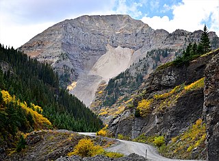
Potosi Peak is a 13,786-foot-elevation (4,202-meter) mountain summit located in Ouray County of Colorado, United States. It is situated five miles southwest of the community of Ouray, on land managed by Uncompahgre National Forest. It is part of the Sneffels Range which is a subset of the San Juan Mountains, which in turn is part of the Rocky Mountains. It is situated west of the Continental Divide, 2.2 miles south of Whitehouse Mountain, and 2.5 miles southeast of Mount Sneffels. Potosi ranks as the 113th-highest peak in Colorado, and the fourth-highest in the Sneffels Range. Recreation enthusiasts heading for Yankee Boy Basin traverse below the southern base of the mountain. Topographic relief is significant as the southeast aspect rises 4,000 feet above the Camp Bird Mine in approximately 1.5 mile. The mining activity in the immediate area produced significant amounts of gold and silver. "Potosi" in Quechuan language translates to "great wealth.". The mountain's name, which has been officially adopted by the United States Board on Geographic Names, was in use before 1899 when Henry Gannett published it in A Dictionary of Altitudes in the United States.

Whitehouse Mountain is a 13,492-foot-elevation (4,112-meter) mountain summit located in Ouray County of southwest Colorado, United States. It is situated four miles west of the community of Ouray, on land managed by Uncompahgre National Forest. It is part of the Sneffels Range which is a subset of the San Juan Mountains, which in turn is part of the Rocky Mountains. It is west of the Continental Divide, 2.2 miles north of Potosi Peak, and 3.2 miles east-northeast of Mount Sneffels. Topographic relief is significant as the east aspect rises 5,680 feet above the town of Ouray in approximately four miles. The mountain's name, which has been officially adopted by the United States Board on Geographic Names, was in use before 1906 when Henry Gannett published it in the Gazetteer of Colorado.

Mount Ridgway is a 13,468-foot-elevation (4,105-meter) mountain summit located in Ouray County of southwest Colorado, United States. It is situated five miles west of the community of Ouray, on land managed by Uncompahgre National Forest. It is part of the Sneffels Range which is a subset of the San Juan Mountains, which in turn is part of the Rocky Mountains. It is west of the Continental Divide, 2.2 miles east-northeast of Mount Sneffels, and 0.95 miles southwest of Whitehouse Mountain, which is the nearest higher neighbor. Topographic relief is significant as the west aspect rises 3,000 feet above Blaine Basin in one mile.

Stony Mountain is a 12,698-foot-elevation (3,870-meter) mountain summit located in Ouray County of southwest Colorado, United States. It is situated five miles southwest of the community of Ouray, on land managed by Uncompahgre National Forest. It is part of the Sneffels Range which is a subset of the San Juan Mountains, which in turn is part of the Rocky Mountains. It is situated west of the Continental Divide, 1.3 miles southwest of Potosi Peak, and 1.15 miles northeast of parent Mount Emma. Yankee Boy Basin is surrounded by Stony Mountain, Gilpin Peak, Mount Sneffels, Cirque Mountain, and Teakettle Mountain. Topographic relief is significant as the east aspect rises 2,000 feet above Sneffels Creek in less than one mile. The mountain's name, which has been officially adopted by the United States Board on Geographic Names, was in use before 1899 when Henry Gannett published it in A Dictionary of Altitudes in the United States.
United States Mountain is a 13,036-foot-elevation (3,973-meter) mountain summit located in Ouray County of southwest Colorado, United States. It is situated six miles southwest of the community of Ouray, on land managed by Uncompahgre National Forest. It is part of the Sneffels Range which is a subset of the San Juan Mountains, which in turn is part of the Rocky Mountains. It is set west of the Continental Divide, 2.3 miles south of Potosi Peak, and 2.5 miles southeast of Stony Mountain. Recreation enthusiasts heading for Yankee Boy Basin traverse below the northern base of the mountain. Topographic relief is significant as the north aspect rises 3,300 feet above the Camp Bird Mine in approximately one mile. Mining activity in the immediate area produced significant amounts of gold and silver. The Hidden Treasure Mine is a gold mine located on the south slope at 11,759-feet elevation.

Cirque Mountain is a 13,686-foot-elevation (4,171-meter) mountain summit located in Ouray County of southwest Colorado, United States. It is situated six miles west of the community of Ouray, above the north side of Yankee Boy Basin, on land managed by Uncompahgre National Forest. It is part of the Sneffels Range which is a subset of the San Juan Mountains, which in turn is part of the Rocky Mountains. Cirque ranks as the 155th-highest peak in Colorado, and the ninth-highest in the Sneffels Range. It is west of the Continental Divide, 1.12 mile east of Mount Sneffels, and 0.59 mile west of Teakettle Mountain, which is the nearest higher neighbor. Topographic relief is significant as the north aspect rises 3,000 feet above Blaine Basin in one mile, and the south aspect rises over 2,000 feet above Yankee Boy Basin in less than one mile. These basins are cirques which were carved by ancient glaciers. The mountain's name has been officially adopted by the United States Board on Geographic Names.

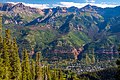
Palmyra Peak is a 13,319-foot-elevation (4,060-meter) mountain summit located in San Miguel County of southwest Colorado, United States. It is situated four miles south of the town of Telluride, on land managed by Uncompahgre National Forest. It is part of the San Juan Mountains which are a subset of the Rocky Mountains, and is west of the Continental Divide. It is immediately south of Telluride Ski Resort, from which it is a prominent landmark, and Palmyra has the distinction of having the highest inbounds skiing terrain of any North American ski resort. Topographic relief is significant as the north aspect rises 2,300 feet above Prospect Basin in one mile, and the west aspect rises 2,100 feet above Alta Lakes in one-half mile. The mountain's name has been officially adopted by the United States Board on Geographic Names in association with the Palmyra Mine, a gold and silver mine located at an elevation of 11,650-feet on the peak's western aspect. Other mines on its flanks included Lakeview Mine, Mountain Quail Mine, Roy Johnston mine, and Turkey Creek Mine.

Silver Mountain is a 13,470-foot-elevation (4,106 meter) mountain summit located in San Miguel County of southwest Colorado, United States. It is situated 4.5 miles south of the town of Telluride, on land managed by Uncompahgre National Forest. It is part of the San Juan Mountains which are a subset of the Rocky Mountains, and is west of the Continental Divide. Silver Mountain ranks as the 274th-highest peak in Colorado, and topographic relief is significant as the south aspect rises 3,770 feet above Ophir in 1.5 mile. The mountain's name has been officially adopted by the United States Board on Geographic Names in association with silver mines on the peak's flanks.

Chicago Peak is a 13,385-foot-elevation (4,080-meter) mountain summit located on the shared boundary of San Miguel County with Ouray County in southwest Colorado, United States. It is situated four miles (6.4 km) east of the community of Telluride, on land managed by Uncompahgre National Forest. It is part of the Sneffels Range which is a subset of the San Juan Mountains, which in turn are part of the Rocky Mountains. It is set above the ghost town of Tomboy, one mile (1.6 km) south of United States Mountain, and one mile northwest of Imogene Pass. Topographic relief is significant as the east aspect rises 2,000 feet above Imogene Basin in approximately one mile, and the west aspect rises 2,000 feet above Savage Basin in less than one mile. Mining activity in the immediate area produced significant amounts of gold and silver.

Ajax Peak is a 12,785-foot-elevation (3,897-meter) mountain summit located in San Miguel County of southwest Colorado, United States. It is situated on land managed by Uncompahgre National Forest, and is the iconic landmark visible three miles east of the community of Telluride. Ajax is set immediately south of Savage Basin and the ghost town of Tomboy, one mile southwest of Chicago Peak, and one mile west of Telluride Peak. It is also immediately northeast of Bridal Veil Falls, Colorado's highest waterfall at 365-feet high. It is part of the San Juan Mountains which are a subset of the Rocky Mountains. Topographic relief is significant as the west aspect rises 3,800 feet above the box canyon in approximately one mile. The old mill town of Pandora at the base of Ajax Peak was hit by snow slides each winter, and one particularly bad event in 1884 came over the Ajax Mine and wrecked the mills.

Ulysses S Grant Peak is a 13,767-foot-elevation (4,196-meter) mountain summit located on the shared boundary of San Juan County with San Miguel County, in southwest Colorado, United States. It is situated eight miles west of the community of Silverton, on land managed by San Juan National Forest and Uncompahgre National Forest. Ulysses S Grant Peak is part of the San Juan Mountains which are a subset of the Rocky Mountains, and is west of the Continental Divide. It ranks as the 119th-highest peak in Colorado, and topographic relief is significant as the west aspect rises 2,400 feet in approximately one mile. The mountain's name, which has been officially adopted by the United States Board on Geographic Names, was in use in an 1896 scientific publication by Charles Whitman Cross, and listed by Henry Gannett when he published A Gazetteer of Colorado in 1906.

Cross Mountain is a 12,703-foot-elevation (3,872-meter) summit on the border shared by Dolores and San Miguel County, in Colorado, United States.

North Pole Peak is a 12,208-foot-elevation (3,721-meter) mountain summit located in San Miguel County, Colorado, United States.