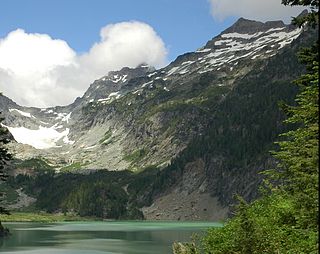
Kyes Peak, which is also known as "Goblin Peak", is a mountain peak located in the Henry M. Jackson Wilderness in Washington, United States. Kyes Peak rises to over 7,280 feet (2,220 m). Together with Columbia Peak and Monte Cristo Peak it forms a basin that contains Columbia Glacier and Blanca Lake. It is the highest summit in the Monte Cristo group of peaks.

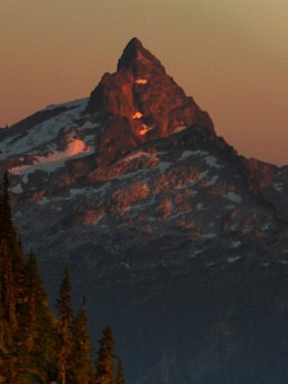
Mount Pugh is a peak near the western edge of the North Cascades, in Washington state. It is located 12.2 miles (19.6 km) west of Glacier Peak, one of the Cascade stratovolcanoes. It rises out of the confluence of the White Chuck River and the Sauk River, giving it very low footings. For example, it rises 6,150 feet (1,875 m) above the Sauk River Valley in just over 2 horizontal miles (3.2 km); its rise over the White Chuck River is almost as dramatic. The mountain is named for John Pugh, who settled nearby, in 1891.
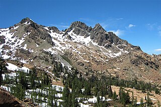
Sloan Peak is a 7,835-foot (2,388-metre) mountain in the North Cascades of Washington state. It rises about 40 miles (64 km) east of Everett, Washington and 12 miles southwest of Glacier Peak, one of the Cascade stratovolcanoes. It is located between the north and south forks of Sauk River, in the Mount Baker–Snoqualmie National Forest. The summit is situated about 4 miles (6.4 km) east of the Mountain Loop Highway.

Sahale Mountain is a jagged, glaciated mountain, in North Cascades National Park, in northern Washington state. The summit of Sahale Mountain is referred to as Sahale Peak. It is 0.3 miles (0.48 km) south of its higher neighbor, Boston Peak, and the saddle between the two is 80 feet (24 m) lower than Sahale's summit. Quien Sabe Glacier is to the west of the ridge between the two peaks while Davenport Glacier is in a cirque east of this ridge and above Horseshoe Basin. Sahale Glacier is south of the summit and east of Sahale Arm, a ridge that extends southwest from Sahale to Cascade Pass. The name Sahale may originate from a Northwest Native American word meaning "high place," "falcon," or "sacred."

Dragontail Peak, also known as Dragon Tail, is a mountain in the Stuart Range, in Chelan County, Washington. While climbing an adjacent peak, Lex Maxwell, Bob McCall, and Bill Prater remarked that the needles on the crest, southwest of the summit, resembled a "dragon tail". The name was officially accepted in 1955. On the mountain's northeast flank lies Colchuck Lake which drains into Mountaineer Creek, and Colchuck Glacier lies below the western slopes of the peak. On its south side the mountain drops steeply to Ingalls Creek, which flows about 5,800 feet (1,800 m) below the summit.

Buckner Mountain is a tall peak in the North Cascades of Washington state and in the Stephen Mather Wilderness of North Cascades National Park. At 9,114 feet (2,778 m) in elevation it is the highest in Skagit County and one of about ten of Washington's non-volcanic peaks above 9,000 feet high. It is ranked as the 14th highest peak in the state, and the third highest peak in North Cascades National Park.

Mount Redoubt is a mountain in the North Cascades range in Whatcom County, Washington state. The peak is located 3.0 miles (5 km) from the Canada–US border, 16.3 miles (26 km) east-northeast of Mount Shuksan. It is the 21st highest peak in the state, with a height of 8,956 feet (2,730 m) and a prominence of 1,649 feet (503 m). Redoubt is in the Skagit Range, a sub-range of the North Cascades, in the Custer-Chilliwack Group which includes Mount Spickard, Mount Redoubt, Mount Custer and Mox Peaks, among others. Redoubt, Bear, and Depot creeks drain off the mountain, which is composed of Skagit gneiss. Mount Redoubt is listed as one of the "Classic Eight Peaks" in the North Cascades.

Mount Challenger is in North Cascades National Park in the U.S. state of Washington. A difficult peak to approach due to its isolation, one of the most common routes to the summit involves ascending the Challenger Glacier on the north slopes of the peak. Mount Challenger is one of the taller peaks of the Picket Range.

Lichtenberg Mountain is a 5,844-foot (1,781-metre) mountain summit located 2.8 miles (4.5 km) north of Stevens Pass in the Okanogan-Wenatchee National Forest of the U.S state of Washington. It rises steeply above the east shore of Lake Valhalla, and less steeply above the west shore of Lichtenwasser Lake. Surface runoff from the mountain drains into tributaries of Nason Creek which in turn is a tributary of the Wenatchee River

Gilbert Mountain is an 8,023-foot (2,445-metre) massif located in Okanogan County in Washington state. It is part of the North Cascades Range, and is situated in the Lake Chelan-Sawtooth Wilderness. The northwestern extreme of the Gilbert massif connects to the southern end of Kangaroo Ridge. Precipitation runoff from the mountain drains into the Twisp River. Topographic relief is significant as it rises over 4,000 feet above the river in approximately one mile.
Stevens Peak is a 6,560-foot (2,000-metre) mountain summit in the Tatoosh Range which is a sub-range of the Cascade Range. It's located in Mount Rainier National Park, one mile east of Unicorn Peak. The name honors Hazard Stevens who made the first documented ascent of Mount Rainier along with P. B. Van Trump on August 17, 1870. The mountain's name was officially adopted in 1913. Precipitation runoff from the mountain drains into tributaries of the Cowlitz River.

Garfield Mountain, also known as Mount Garfield, is a multi-peak summit located in King County of Washington state. It's located on the western edge of the Cascade Range and is within the Alpine Lakes Wilderness on land managed by Mount Baker-Snoqualmie National Forest. Mount Garfield is more notable for its large, steep rise above local terrain than for its absolute elevation. Precipitation runoff from the mountain drains into tributaries of the Snoqualmie River. Topographic relief is significant as it rises over 4,400 feet above the river in approximately one mile. The mountain's name honors James A. Garfield, the 20th President of the United States.
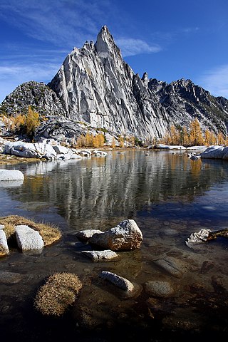
Prusik Peak is an 8000+ ft granite summit located at the west end of The Temple in Chelan County of Washington state. Prusik Peak is part of The Enchantments within the Alpine Lakes Wilderness, and is often the iconic photographic image of both areas. Prusik Peak belongs to the Stuart Range which is a subset of the Cascade Range. The name honors Dr. Karl Prusik (1896–1961) who was an Austrian mountaineer, and is known as the inventor of the prusik, a rope knot which happened to be used to gain access to the summit horn during the first ascent by Fred Beckey in 1948. Precipitation runoff drains into Icicle Creek, a tributary of the Wenatchee River.

Mount Persis is a 5,464 ft summit located in Snohomish County, of Washington state. The mountain is part of the Cascade Range and is situated in the Mount Baker-Snoqualmie National Forest. The mountain was named for Persis Gunn, the wife of homesteader/miner Amos Gunn who started the nearby town of Index, Washington, and also named nearby Mount Index. Precipitation runoff from the mountain drains into tributaries of the Skykomish River. The rocks of Mount Persis are volcanic in origin and are considered amongst some of the earliest expressions of volcanism in the Cascade Mountain range in Washington.

Tenpeak Mountain is an 8,200+ ft granitic mountain summit located in the Glacier Peak Wilderness of the North Cascades in Washington state. Fred Beckey's Cascade Alpine Guide has the elevation of the mountain as 8,281 feet. Tenpeak is situated on the crest of the Cascade Range, on the shared border of Snohomish County and Chelan County, also straddling the boundary between the Mount Baker-Snoqualmie National Forest and the Wenatchee National Forest. Its nearest higher neighbor is Luahna Peak, 2.5 mi (4.0 km) to the southeast. Topographic relief is significant since the northern aspect of the mountain rises 4,200 feet above the Suiattle Valley in approximately 1.5 mi (2.4 km). This mountain has small, unnamed, hanging glaciers in cirques surrounding the summit, and the terminus of the Honeycomb Glacier lies below the western base of the mountain. Precipitation runoff from the mountain and meltwater from the glaciers drains south into White River; or north into the Suiattle River. This mountain's descriptive name was suggested by The Mountaineers, and was officially adopted in 1918 by the U.S. Board on Geographic Names. The first ascent was made September 21, 1940, by Lloyd Anderson and Tom Campbell.
Ingalls Peak is a 7,662-foot (2,335-metre) triple-summit mountain located in the Alpine Lakes Wilderness, along the common border of Kittitas County and Chelan County, in Washington state. Ingalls Peak is the highest point in the Teanaway area of the Wenatchee Mountains. It is situated 2 mi (3.2 km) west of Mount Stuart, and immediately west of Lake Ingalls, on land managed by Wenatchee National Forest. Its subpeaks are the South Peak and the East Peak. Precipitation runoff from the peak drains north into Jack Creek, a tributary of Icicle Creek; west into Fortune Creek; or east into Ingalls Creek, a tributary of the Wenatchee River. This peak, the lake, creek, and pass are named for Captain Benjamin Ingalls of the United States Cavalry who led an 1855 survey of this area and is credited with discovering gold in the region.

Little Big Chief Mountain is a 7,225-foot (2,202-metre) mountain summit located immediately southwest of Dutch Miller Gap, on the common border separating King County and Kittitas County in Washington state. It is situated within the Alpine Lakes Wilderness, on land managed by Mount Baker-Snoqualmie National Forest. Little Big Chief Mountain is set ten miles northeast of Snoqualmie Pass on the crest of the Cascade Range. Precipitation runoff from the west side of the mountain drains into tributaries of the Snoqualmie River, whereas the east side drains into tributaries of the Yakima River. The nearest higher peak is Summit Chief Mountain, 0.7 miles (1.1 km) to the southwest, and Chimney Rock is set 2.2 miles (3.5 km) to the southwest. The first ascent of this peak was made in August 1939 by Fred Beckey, Wayne Swift, Joe Barto, and Campbell Brooks. This mountain was named for Lorenz A. Nelson during the 1925 Mountaineers climb of Summit Chief Mountain. Nelson was a pioneering mountaineer who led first ascents of Mount Olympus, Mount Meany, and Chiwawa Mountain.

Spire Mountain is a 6,213-foot (1,894-metre) Cascade Range mountain summit located in Snohomish County, Washington. It is set 7 miles (11 km) northeast of the town of Index, and 4 miles (6.4 km) north-northeast of Gunn Peak, its nearest higher neighbor. This mountain is situated in the Wild Sky Wilderness, on land managed by Mount Baker-Snoqualmie National Forest. Precipitation runoff from the mountain drains into tributaries of the Skykomish River. The first ascent of the highest Northwest Spire was made in 1934 by Dwight Dean and Kenneth Chapman. The first ascent of the Central Spire (6,200-ft) was made in 1938 by Karl Boyer, Lyman Boyer, and David Lind. The Southeast Spire is estimated as 6,185 feet in elevation.

North Big Bosom Butte is a 6,384-foot (1,946-metre) mountain summit located in Whatcom County of Washington state.

Wedge Mountain is a 5,860-foot-elevation (1,786-meter) summit located in Chelan County of Washington state. It is set on the boundary line of the Alpine Lakes Wilderness, on land managed by Okanogan-Wenatchee National Forest. Wedge Mountain is the northeastern terminus of the Stuart Range, which is a subset of the Cascade Range. It is situated 3.5 miles (5.6 km) northeast of The Temple, and the nearest town is Leavenworth, 5 miles (8.0 km) to the north-northeast. Precipitation runoff from the mountain drains into tributaries of the Wenatchee River. Topographic relief is significant as the summit rises over 2,800 feet above Snow Creek in one-half mile. Backpackers hiking en route to The Enchantments via the Snow Creek Trail traverse the western foot of this mountain. Wedge Mountain is the toponym officially adopted by the U.S. Board on Geographic Names for the 5,860-foot summit.


