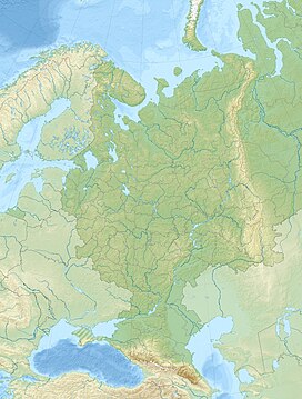
The Ural Mountains or simply the Urals, are a mountain range that runs approximately from north to south through western Russia, from the coast of the Arctic Ocean to the river Ural and northwestern Kazakhstan. The mountain range forms part of the conventional boundary between the regions of Europe and Asia. Vaygach Island and the islands of Novaya Zemlya form a further continuation of the chain to the north into the Arctic Ocean.

The Hida Mountains, or Northern Alps, is a Japanese mountain range which stretches through Nagano, Toyama and Gifu prefectures. A small portion of the mountains also reach into Niigata Prefecture. William Gowland coined the phrase "Japanese Alps" during his time in Japan, but he was only referring to the Hida Mountains when he used that name. The Kiso and Akaishi mountains received the name in the ensuing years.

Alexander Petrovich Karpinsky was a prominent Russian and Soviet geologist and mineralogist, and the president of the Russian Academy of Sciences, and later Academy of Sciences of the USSR, in 1917–1936.

October Revolution Island is the largest island of the Severnaya Zemlya group in the Russian Arctic. It is named after the October Revolution which led to Russia becoming a communist country.

Helicoprion is an extinct genus of shark-like eugeneodont fish. Almost all fossil specimens are of spirally arranged clusters of the individuals' teeth, called "tooth whorls", which in life were embedded in the lower jaw. As with most extinct cartilaginous fish, the skeleton is mostly unknown. Fossils of Helicoprion are known from a 20 million year timespan during the Permian period from the Artinskian stage of the Cisuralian to the Roadian stage of the Guadalupian. The closest living relatives of Helicoprion are the chimaeras, though their relationship is very distant. The unusual tooth arrangement is thought to have been an adaption for feeding on soft bodied prey, and may have functioned as a deshelling mechanism for hard bodied cephalopods such as nautiloids and ammonoids. In 2013, systematic revision of Helicoprion via morphometric analysis of the tooth whorls found only H. davisii, H. bessonowi and H. ergassaminon to be valid, with some of the larger tooth whorls being outliers.

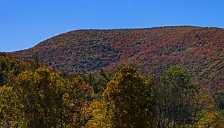
Mount Frissell, 2,454 feet (748 m), which straddles the border of southwest Massachusetts and northwest Connecticut, is a prominent peak of the Taconic Range.
In the geologic timescale, the Sakmarian is an age or stage of the Permian. It is a subdivision of the Cisuralian epoch or series. The Sakmarian lasted between 295 and 290.1 million years ago (Ma). It was preceded by the Asselian and followed by the Artinskian.

The Karpinsky Group is a volcanic group located at the southern end of Paramushir Island, Kuril Islands, Russia. The group is capped by two gently sloping cones rising to a height of 1,326 m. They are composed of andesites and andesite-basalts. In the two craters there are fumaroles and fountains of liquid sulfur. The last major, and only historic, eruption was in 1952. The sides of the volcanoes have been heavily glaciated leaving a number of cirques which were initially thought to be eroded craters. The volcanoes were named after the geologist Aleksandr Petrovich Karpinsky.
Karpinski, Karpiński, or Karpinsky may refer to:
Yugyd Va National Park is a national park in the Komi Republic, a constituent republic of the Russian Federation. It is Europe's largest national park and it was Russia's largest national park until the creation of Beringia National Park in 2013.
Mount Karpinsky may refer to:

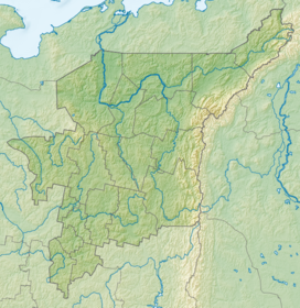
The Research Range is a mountain range at the northern end of the Ural Mountains. It extends north of the Arctic Circle, and forms the border between the Komi Republic and the Khanty–Mansi Autonomous Okrug. The Research Range is 175 km long and the highest point is Mount Narodnaya or People's Mountain, at 1,894 m.

Mount Redfield is a mountain located in Essex County, New York. The mountain is part of the Marcy Group of the Great Range of the Adirondack Mountains. Mount Redfield is flanked to the northwest by Cliff Mountain, and to the northeast by Mount Skylight.

Mount Emmons is a mountain located in the Adirondack Mountains near the southern edge of Franklin County, New York, United States.
Mount Sherrill is a mountain located in Greene County, New York, and is named after Eliakim Sherrill, and is part of the Catskill Mountains. Mount Sherrill is flanked to the east by North Dome, and to the west by Balsam Mountain.

Alander Mountain, 2,239 feet (682 m), is a prominent peak of the south Taconic Mountains; it is located in southwest Massachusetts and adjacent New York. Part of the summit is grassy and open and part is covered with scrub oak and shrubs; the sides of the mountain are wooded with northern hardwood tree species. Views from the top include the southern Taconic Mountains, the Hudson River Valley including the Catskills. Several trails traverse Alander Mountain, most notably the 15.7 mi (25.3 km) South Taconic Trail, which passes just beneath the summit.
Round Mountain, 2,296 feet (700 m), located on the border of southwest Massachusetts and northwest Connecticut, is a prominent peak of the Taconic Range. The peak and southern slopes of the mountain are within Connecticut; the northern slope lies within Massachusetts.
Suzuka Mountains are a mountain range running through Mie Prefecture and along the borders of Gifu and Shiga prefectures in central Japan. The tallest peak in the range is Mount Oike at 1,247 m (4,091 ft). In spite of its height, Mount Oike is not the most visited mountain; that distinction belongs to Mount Gozaisho because of its Gozaisho Ropeway, making reaching the peak much easier.
Mount Clarke is a mountain in southwestern British Columbia, Canada, located 21 km (13 mi) northwest of Hemlock Valley and 6 km (4 mi) south of Grainger Peak. It is part of the Douglas Ranges, the southernmost subdivision of the Pacific Ranges which in turn form part of the Coast Mountains.
Karpinsky Glacier or Karpinsky Ice Cap, also known as Mount Karpinsky, is a large ice cap on October Revolution Island, Severnaya Zemlya, Russian Federation.