Morgan County is a county in northern Utah, United States. As of the 2020 census, the population was 12,295. Its county seat and largest city is Morgan. Morgan County is part of the Ogden-Clearfield, UT Metropolitan Statistical Area as well as the Salt Lake City-Provo-Orem, UT Combined Statistical Area.

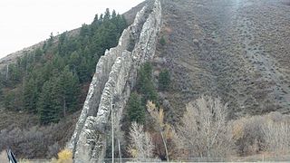
The Wasatch Range or Wasatch Mountains is a mountain range in the western United States that runs about 160 miles (260 km) from the Utah-Idaho border south to central Utah. It is the western edge of the greater Rocky Mountains, and the eastern edge of the Great Basin region. The northern extension of the Wasatch Range, the Bear River Mountains, extends just into Idaho, constituting all of the Wasatch Range in that state.

Mount Mansfield is the highest mountain in Vermont with a summit that peaks at 4,393 feet (1,339 m) above sea level. The summit is located within the town of Underhill in Chittenden County; the ridgeline, including some secondary peaks, extends into the town of Stowe in Lamoille County, and the mountain's flanks also reach into the town of Cambridge.
Deer Valley is an alpine ski resort in the Wasatch Range, located 36 miles (58 km) east of Salt Lake City, in Park City, Utah, United States. The resort, known for its upscale amenities, is consistently ranked among the top ski resorts in North America.

Snowbird is an unincorporated community in Little Cottonwood Canyon in the Wasatch Range of the Rocky Mountains near Salt Lake City, Utah, United States. It is most famous for Snowbird Ski and Summer Resort, an alpine skiing and snowboarding area, which opened in December 1971.

Little Cottonwood Canyon lies within the Wasatch-Cache National Forest along the eastern side of the Salt Lake Valley, roughly 15 miles from Salt Lake City, Utah. The canyon is part of Granite, a CDP and "Community Council" designated by Salt Lake County. The canyon is a glacial trough, carved by an alpine glacier during the last ice age, 15,000 to 25,000 years ago. A number of rare and endemic plant species are found in the canyon's Albion Basin. Mountain goats inhabit the surrounding mountains.

Mount Nebo is the southernmost and highest mountain in the Wasatch Range of Utah, in the United States, and the centerpiece of the Mount Nebo Wilderness, inside the Uinta National Forest. It is named after the biblical Mount Nebo, overlooking Israel from the east of the Jordan river, which is said to be the place of Moses' death.

Mount San Antonio, commonly referred to as Mount Baldy or Old Baldy, is a 10,064 ft (3,068 m) summit in the San Gabriel Mountains on the border of Los Angeles and San Bernardino counties of California. Lying within the San Gabriel Mountains National Monument and Angeles National Forest, it is the high point of the range, the County of Los Angeles, and the Los Angeles metropolitan area.

Mount Tom is a large and prominent peak near the city of Bishop in Inyo County of eastern California. It is in the Sierra Nevada and east of the Sierra Crest. The mountain is also in the John Muir Wilderness.

Notch Peak is a distinctive summit located on Sawtooth Mountain in the House Range, west of Delta, Utah, United States. The peak and the surrounding area are part of the Notch Peak Wilderness Study Area (WSA). Bristlecone pines, estimated to be 3,000 to 4,000 years old, are located on the ridges surrounding Notch Peak.

The geography of the U.S. State of Colorado is diverse, encompassing both rugged mountainous terrain, vast plains, desert lands, desert canyons, and mesas. Colorado is a landlocked U.S. state. In 1861, the United States Congress defined the boundaries of the new Territory of Colorado exclusively by lines of latitude and longitude, stretching from 37°N to 41°N latitude, and from 102°02'48"W to 109°02'48"W longitude. Starting in 1868, official surveys demarcated the boundaries, deviating from the parallels and meridians in several places. Later surveys attempted to correct some of these mistakes but in 1925 the U.S. Supreme Court affirmed that the earlier demarcation was the official boundary. The borders of Colorado are now officially defined by 697 boundary markers connected by straight boundary lines. Colorado, Wyoming, and Utah are the only states that have their borders defined solely by straight boundary lines with no natural features. The southwest corner of Colorado is the Four Corners Monument at 36°59'56"N, 109°2'43"W. This is the only place in the United States where four states meet: Colorado, New Mexico, Arizona, and Utah.

Park City Mountain Resort (PCMR) is a ski resort in the western United States in Park City, Utah, located 32 miles (51 km) east of Salt Lake City. Park City, as the ski resort and area is known, contains several training courses for the U.S. Ski Team, including slalom and giant slalom runs. During the 2002 Winter Olympics, it hosted the snowboarding events and the men's and women's alpine giant slalom events.

Mount Ellen is a mountain located in Garfield County, Utah, United States.

Mount Wire is a mountain located on the east side of Salt Lake City, Utah with an elevation of 7,146 feet (2,178 m). The mountain is named after Lester Wire, an American policeman of Salt Lake City, Utah, who in 1912 developed the first red-green electric traffic light. Mount Wire is a common spot for adventurous hikers and has many access trails, some created by nearby Red Butte Gardens. The east side of the University of Utah offers direct access to trails to the summit. Mount Wire formerly could be identified from other nearby mountains by its two passive microwave repeaters near the summit. These billboard like structures were used to bounce microwave signals over the mountain to the north-eastern parts of Utah. Mount Wire also houses an old airway beacon directly on the summit. An interesting man-made rock outcropping about halfway up the mountain looks like several lawn chairs in a row, and is a common rest stop for hikers. This stop offers views of Salt Lake City, and the Wasatch Mountains.

Mount Rose is the highest mountain in Washoe County, within the Carson Range of Nevada, United States. It ranks thirty-seventh among the most topographically prominent peaks in the state. It is also both the highest and most topographically prominent peak of the greater Sierra Nevada range within the state of Nevada, and the third most topographically prominent peak in the Sierra Nevada overall. It is located in the Mount Rose Wilderness of the Humboldt-Toiyabe National Forest. An extinct volcano, the mountain is in between Lake Tahoe and Reno. State Route 431 traverses Mount Rose Summit southeast of Mount Rose. Due to the high elevation, most of the precipitation that falls on the mountain is snow. The view from Mount Rose, facing east is the Truckee Meadows area is the second largest population center in Nevada.

Brian Head, at 11,312 feet (3,448 m) high, is the highest peak on the Markagunt Plateau and in Iron County in southwestern Utah, United States. Brian Head Peak is located east of Cedar City and just north of Cedar Breaks National Monument in Dixie National Forest. The town of Brian Head at the western base of the mountain is the location of the Brian Head Ski Resort.
Cherry Peak is a ski area in northern Utah that opened in 2014 and first used for skiing in the 2015–2016 season. It is located in Cherry Canyon, east of Richmond, Utah in the Bear River Mountains. While smaller and less developed than a number of Utah ski resorts, Cherry Peak is close and convenient to residents of nearby Logan, Utah State University, and Cache Valley. It also hosts students from more distant universities.

Mount Superior is an 11,045 feet (3,367 m) mountain peak in the Uinta-Wasatch-Cache National Forest in Salt Lake County, Utah, United States.

Kesler Peak is a 10,403-foot elevation (3,171 m) mountain summit located in Salt Lake County, Utah, United States.


