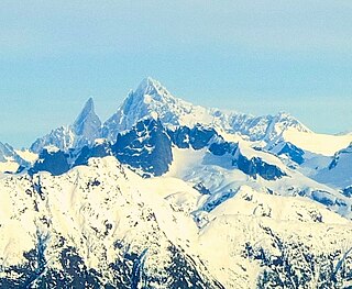
Mount Blachnitzky is a 6,552 ft (2,000 m) mountain summit in the city and borough of Juneau, Alaska, United States. It is a part of the Boundary Ranges of the Coast Mountains in western North America. It is located between Gilkey Glacier and Avalanche Canyon; it is named after Klaus Blachnitzky (1921-1988), a surveyor, geodesist, and explorer of the Juneau Icefield. Mr. Blachnitzky was the head surveyor for the Juneau Icefield Research Program. Much of his work was conducted in the vicinity of this summit. In August 1988, having completed almost two seasons instructing student surveyors and scientists in the science and practice of terrestrial field surveying and geodesy, he was killed when he slipped from a rock cleaver on the slope of Vaughan Lewis Glacier. The site of his death is four miles from the mountain named in his honor. In 2004, four climbers made a memorial climb of the previously unclimbed summit, leaving at the peak some surveying mementos of Mr. Blachnitzky's life. That first ascent was made by Scott McGee, Keith Daellenbach, Charles Daellenbach, and Fred Skemp III, on June 30, 2004, via the southwest cirque/south ridge. The mountain's name was officially adopted in 2007 by the U.S. Board on Geographic Names.

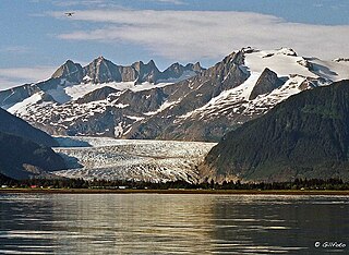
Stroller White Mountain, also known as Mount Stroller White, is a 5,118-foot (1,560 m) mountain summit located in the Boundary Ranges, in the U.S. state of Alaska. The peak is situated near the toe of the Mendenhall Glacier, within Tongass National Forest, 12 mi (19 km) north-northwest of Juneau, Alaska, and 8 mi (13 km) north of Juneau International Airport. Although modest in elevation, relief is significant since the mountain rises up from sea-level in less than seven miles. Stroller White Mountain is often seen and photographed with McGinnis Mountain, a 4,199-foot (1,280 m) summit 1.6 mi (3 km) south, because they are together in the background behind Mendenhall Lake, a popular tourist and recreation area.
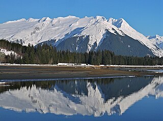
Mount Wrather is a 5,968-foot (1,819 m) mountain summit located in the Boundary Ranges, in the U.S. state of Alaska. The peak is situated within Tongass National Forest, immediately east of the Mendenhall Glacier, 12 mi (19 km) north of Juneau, Alaska, and 9 mi (14 km) north of Juneau International Airport. Although modest in elevation, relief is significant since the mountain rises up from sea-level at Auke Bay in less than nine miles. The mountain's name was officially adopted in 1968 by the USGS to honor William Embry Wrather (1883–1963), the 6th Director of the United States Geological Survey from 1943 to 1956.

Mount Forde, also known as Boundary Peak 161, is a 6,883-foot (2,098 m) mountain summit located in the Fairweather Range of the Saint Elias Mountains, on the Canada–United States border between southeast Alaska and British Columbia. The peak is situated on the boundary of Glacier Bay National Park and Preserve, near the head of Tarr Inlet, 109 mi (175 km) northwest of Juneau, and 4.4 mi (7 km) northeast of Mount Turner, which is the nearest higher peak. Although modest in elevation, relief is significant since the mountain rises up from tidewater in less than four miles.

Horn Spire is a 6,700+ ft mountain summit located in the Boundary Ranges of the Coast Mountains, in the U.S. state of Alaska. The peak is situated between the Thiel Glacier and Battle Glacier at the northwest extent of the Juneau Icefield, 31 mi (50 km) north-northwest of Juneau, Alaska, and 12 mi (19 km) east of Lynn Canal, on land managed by Tongass National Forest. Horn Spire is the highest point of the Icefall Spires, and although modest in elevation, relief is significant since the north face of the mountain rises over 4,700 feet above the Thiel Glacier in less than one mile. The peak's descriptive name was submitted in 1965 by Maynard Miller, director of the Juneau Icefield Research Project, and officially adopted that same year by the U.S. Board on Geographic Names. The first ascent of the peak was made June 30, 1973, by Dick Benedict, Gerry Buckley, Craig Lingle, and Bruce Tickell.
Mount Ernest Gruening is a 6,015+ ft glaciated mountain summit located in the Boundary Ranges of the Coast Mountains, in the U.S. state of Alaska. The long ridge-like mountain is situated between the Herbert Glacier and Eagle Glacier at the west edge of the Juneau Icefield, 20 mi (32 km) northwest of Juneau, Alaska, and 8 mi (13 km) east of Favorite Channel, on land managed by Tongass National Forest. Although modest in elevation, relief is significant since the east face of the mountain rises over 3,500 feet above the Herbert Glacier in less than one mile, and the west aspect rises 5,800 feet above the Eagle River valley in two miles.

The Snow Towers is a 7,100+ ft glaciated mountain summit located in the Boundary Ranges of the Coast Mountains, in the U.S. state of Alaska. The two peaks, 0.1 mi apart, are situated at the apex of the Taku and Herbert Glaciers near the western edge of the Juneau Icefield, 23 mi (37 km) north of Juneau, 1.8 mi (3 km) southwest of Snowpatch Crag, and 6.3 mi (10 km) northeast of Mount Ernest Gruening, on land managed by Tongass National Forest. The mountain was named by members of the Juneau Icefield Research Project in 1964, and was officially adopted in 1965 by the U.S. Board on Geographic Names. The first ascent was made in 1984 by Charles "Dick" Ellsworth and Bruce Tickell.

Taku Towers is a 6,653+ ft double summit mountain located in the Boundary Ranges of the Coast Mountains, in the U.S. state of Alaska. The two north and south peaks, 0.2 mi apart with 6,653+ and 6,605-ft elevations respectively, are situated in the Taku Range of the Juneau Icefield, 21 mi (34 km) north of Juneau, Alaska, and 5.5 mi (9 km) east-southeast of The Snow Towers, on land managed by Tongass National Forest. The Taku Range is a north-south trending ridge on the edge of the Taku Glacier. The mountain's name was in local use when first published in 1960 by the U.S. Geological Survey. Several landforms in the vicinity bear this Taku name, which all ultimately derive from the Taku people. The first ascent was made in 1949 by Forbes, Merritt, and Schoeblen via the west ridge. Daniel Reid and party made the first ascent of the difficult east face of South Taku Tower in 1973.

Split Thumb is a 5,523 ft (1,680 m) glaciated mountain summit located in the Boundary Ranges of the Coast Mountains, in the U.S. state of Alaska. The peak is situated near the southern periphery of the Juneau Icefield, 9 mi (14 km) northeast of Juneau, 2.15 mi southeast of Nugget Mountain, and 4 mi (6 km) east of Heintzleman Ridge, on land managed by Tongass National Forest. Split Thumb is surrounded by the Lemon Creek Glacier to the west, and Norris Glacier to east. The Split Thumb Icefall is set on the east aspect of the peak. This peak's descriptive name was published in 1951 by the U.S. Geological Survey. The first ascent of Split Thumb was made July 2, 1954, by a Juneau Icefield Research Project party comprising Edward LaChapelle, Dick Hubley, Carlton Ray, Dr. Conrad Buettner, and Bob Goodwin.

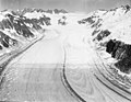
Mount Queena is a 7,620+ ft elevation mountain summit located in the Boundary Ranges of the Coast Mountains, in the U.S. state of Alaska. This unofficially named peak is situated on the Juneau Icefield, 39 mi (63 km) north of Juneau, 2.7 mi (4 km) west of the Canada–United States border, and 5 mi (8 km) northeast of Mount Blachnitzky, on land managed by Tongass National Forest. Although modest in elevation, relief is significant since the east aspect of the mountain rises over 3,200 feet above the Gilkey Glacier in less than one mile. The nearest higher neighbor is Mount Ogilvie, 2.5 mi (4 km) to the east.
Mount Sumdum is a 6,666-foot-elevation (2,032-meter) mountain summit in Alaska, United States.
Mount Burkett is a 9,730-foot-elevation (2,966-meter) mountain summit in Alaska, United States.
The Tusk is a 6,650-foot-elevation (2,027-meter) mountain summit in Alaska, United States.

Mount Bagot is a 2,181-metre (7,156-foot) mountain summit located on, and in part defining, the international border between British Columbia, Canada, and Alaska, United States.

Dike Mountain is a 6,650-foot (2,027 m) glaciated summit located in the Boundary Ranges of the Coast Mountains, in the U.S. state of Alaska. It is situated 26 miles (42 km) north-northwest of Juneau along the western side of the Juneau Icefield, on land managed by Tongass National Forest. Topographic relief is significant as the summit rises 1,150 feet (350 m) above the Eagle Glacier in 0.4 mi (0.64 km). Neighbors include Mustang Peak 0.8 mi (1.3 km) to the south, and Snowpatch Crag is 3.7 miles (6.0 km) to the east. Dike Mountain was named by members of the Juneau Icefield Research Project in 1964, and the toponym was officially adopted in 1965 by the U.S. Board on Geographic Names.
Mustang Peak is a 6,720-foot-elevation (2,048-meter) glaciated mountain summit located in the Boundary Ranges of the Coast Mountains, in the U.S. state of Alaska. It is situated 25 miles (40 km) north-northwest of Juneau along the western side of the Juneau Icefield, on land managed by Tongass National Forest. Topographic relief is significant as the summit rises 1,200 feet (366 m) above the Eagle Glacier in 0.25 mi (0.40 km). Neighbors include Dike Mountain 0.8 mi (1.3 km) to the north, and The Snow Towers are three miles (4.8 km) to the southeast. Mustang Peak was named by members of the Juneau Icefield Research Project in 1964, and the toponym was officially adopted in 1965 by the U.S. Board on Geographic Names.

Mount Adolph Knopf is a 6,200-foot-elevation (1,890-meter) glaciated mountain summit located in the Boundary Ranges of the Coast Mountains, in the U.S. state of Alaska. It is situated 28 miles (45 km) north-northwest of Juneau to the western side of the Juneau Icefield, on land managed by Tongass National Forest. Topographic relief is significant as the summit rises 2,200 feet (670 m) above the Eagle Glacier in 0.5 mi (0.80 km) and 3,800 feet (1,158 m) above the Thiel Glacier in 1.25 mi (2.01 km). Precipitation runoff from the mountain's slopes drains to Lynn Canal.

Glacier King is a 6,500-foot-elevation (1,981-meter) mountain summit in Alaska, United States.

Mount Leland is a 7,810-foot-elevation (2,380-meter) glaciated mountain summit located in the Boundary Ranges of the Coast Mountains, in the U.S. state of Alaska. It is situated 27 miles (43 km) southeast of Skagway along the western edge of the Juneau Icefield, on land managed by Tongass National Forest. Topographic relief is significant as the summit rises 4,400 feet (1,340 m) above the Meade Glacier in 1.25 mi (2.01 km). Precipitation runoff and glacial meltwater from the mountain drains to Lynn Canal via the Katzehin River. Mount Leland's toponym was officially adopted in 1972 by the U.S. Board on Geographic Names to commemorate surveyor Ora Miner Leland (1876–1962), who led the International Boundary Commission Party of 1907. The peak rises a little over four miles (6.4 km) from the US–Canada boundary.

Observation Peak is a 4,931-foot (1,503 m) mountain summit located in the Boundary Ranges of the Coast Mountains, in the U.S. state of Alaska. The peak is situated 4.5 miles (7.2 km) northeast of Juneau along the southern periphery of the Juneau Icefield, on land managed by Tongass National Forest. Precipitation runoff and glacial meltwater from the mountain drains to Gastineau Channel via Lemon and Salmon creeks, whereas the southeast slope drains to Taku Inlet via Carlson Creek. Although modest in elevation, relief is significant as the summit rises over 3,700 feet (1,128 m) above Salmon Creek Reservoir in 1.6 miles (2.6 km). This peak's local name was published in 1962 by the U.S. Geological Survey and the toponym has been officially adopted by the U.S. Board on Geographic Names.