
Adams Morgan, commonly abbreviated as AdMo, is a neighborhood in Washington, D.C., located in Northwest D.C. Adams Morgan is noted as a historic hub for counterculture and as an arts district. It is also known for its popular entertainment district and culinary scene, centered on both 18th Street and Columbia Road.

Columbia Heights station is a Washington Metro station in Washington, D.C., on the Green Line. Due to successful redevelopment since the station's opening, Columbia Heights is one of the busiest Metro stops outside the downtown core, with over four million exits in 2010.

Mount Pleasant is a neighborhood in Washington, D.C., located in Northwest D.C. The neighborhood is primarily residential, with restaurants and stores centered along a commercial corridor on Mt. Pleasant Street. Mount Pleasant is known for its unique identity and multicultural landscape, home to diverse groups such as the punk rock, the Peace Corps and Hispanic Washingtonian communities.

Northwest is the northwestern quadrant of Washington, D.C., the capital of the United States, and is located north of the National Mall and west of North Capitol Street. It is the largest of the four quadrants of the city, and it includes the central business district, the Federal Triangle, and the museums along the northern side of the National Mall, as well as many of the District's historic neighborhoods.

Columbia Heights is a neighborhood in Washington, D.C., located in Northwest D.C. The neighborhood is an important retail hub for the area, as home to DC USA mall and to numerous other restaurants and stores, primarily along the highly commercialized 14th Street. Columbia Heights is home to numerous historical landmarks, including Meridian Hill Park, National Baptist Memorial Church, All Souls Church, along with a number of embassy buildings.

The Historical Society of Washington, D.C., also called the DC History Center, is an educational foundation dedicated to preserving and displaying the history of Washington, D.C. The society provides lectures, exhibits, classes, and community events. It runs a museum, library, and publishes the journal Washington History. It had been named The Columbia Historical Society from its founding in 1894 until 1988.

Takoma, Washington, D.C., is a neighborhood in Washington, D.C. It is located in Advisory Neighborhood Commission 4B, in the District's Fourth Ward, within the northwest quadrant. It borders the city of Takoma Park, Maryland.

Mount Vernon Square is a city square and neighborhood in the Northwest quadrant of Washington, D.C. The square is located where the following streets would otherwise intersect: Massachusetts Avenue NW, New York Avenue NW, K Street NW, and 8th Street NW.

16th Street Northwest, briefly known as the Avenue of the Presidents, is a prominent north-south boulevard in Washington, D.C., located in Northwest D.C. The street was laid out as part of the 1791 L'Enfant Plan, which served as the original blueprint for the city. The street begins just north of the White House, across from Lafayette Square in the President's Park, and continues north along the Washington meridian until Blair Circle.

Petworth is a neighborhood of Washington, D.C., located in Northwest D.C. While largely residential, Petworth is home to a notable commercial corridor of shops and restaurants, primarily along Georgia Avenue and Upshur Street, as well as a portion of 14th Street. The neighborhood is accessible via the Georgia Ave–Petworth station on the Green Line of the Washington Metro.
Woodley Park is a neighborhood in Washington, D.C., located in Northwest D.C. Primarily residential, Woodley Park hosts a commercial corridor of restaurants and shops located along Connecticut Avenue. The neighborhood is noted as the home of the National Zoological Park, part of the Smithsonian Institution.

Downtown is the central business district of Washington, D.C., located in Northwest D.C. It is the third largest central business district in the United States. The "Traditional Downtown" has been defined as an area roughly between Union Station in the east and 16th Street NW in the west, and between the National Mall on the south and Massachusetts Avenue on the north, including Penn Quarter. However, nowadays, Downtown D.C. usually refers to a larger area, as the DC Office of Planning states:
…most residents, workers, and visitors think of Downtown in a broader sense — including areas as far north as Dupont Circle, as far west as Foggy Bottom, and as far east as Capitol Hill. Only about half of the central city workforce is located within the city’s traditional Downtown.

Sixteenth Street Heights is a large neighborhood of rowhouses, duplexes, and American Craftsman and American Foursquare detached houses in Northwest Washington, D.C.
The District of Columbia Public Library (DCPL) is the public library system for Washington, D.C. The system includes 26 individual libraries including Martin Luther King Jr. Memorial Library, DCPL's central library.

The Administration Building, Carnegie Institute of Washington is a Beaux-Arts style building designed by architects Carrere and Hastings, and located at 1530 P Street NW in Washington, D.C. It houses the Carnegie Institution for Science, a philanthropic scientific research organization founded in 1902 by Andrew Carnegie. In recognition of the building's architecture and its unique tenant, the building was declared a National Historic Landmark in 1965. The building was also designated a contributing property to the Sixteenth Street Historic District in 1978.

The Guglielmo Marconi Memorial is a public artwork by Attilio Piccirilli, located at the intersection of 16th and Lamont Streets NW in the Mount Pleasant neighborhood of Washington, D.C. It stands as a tribute to Italian inventor Guglielmo Marconi, whose work with telegraphy and radio waves led to the creation and popularity of the radio. It was paid for by public subscription and erected in 1941. The artwork was listed on both the District of Columbia Inventory of Historic Sites and the National Register of Historic Places in 2007. It is a contributing property to the Mount Pleasant Historic District.
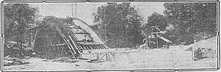
Piney Branch is a tributary of Rock Creek in Washington, D.C. It is the largest tributary located entirely within the Washington city limits. It is spanned by the 16th Street Bridge, the country's first parabolic arch bridge.

The Takoma Park Neighborhood Library is part of the District of Columbia Public Library (DCPL) System. It was opened to the public in 1911.

The Southeast Neighborhood Library is a branch of the District of Columbia Public Library in the Capitol Hill neighborhood of Washington, D.C. It is located at 403 7th Street SE. Designed by architect Edward Lippincott Tilton in the neoclassical style, it opened in 1922 and is one of three Carnegie libraries in Washington. As of 2019, the city planned a $23.5 million renovation of the library starting in 2021. The building was listed on the National Register of Historic Places in 2021.

