Related Research Articles

Alaska is a U.S. state located in the Western United States on the northwest extremity of North America. A semi-exclave of the U.S., it borders the Canadian province of British Columbia and the Yukon territory to the east; it also shares a maritime border with the Russian Federation's Chukotka Autonomous Okrug to the west, just across the Bering Strait. To the north are the Chukchi and Beaufort seas of the Arctic Ocean, while the Pacific Ocean lies to the south and southwest.

Southeast Alaska, colloquially referred to as the Alaska Panhandle or Alaskan Panhandle, is the southeastern portion of the U.S. state of Alaska, bordered to the east by the northern half of the Canadian province of British Columbia. The majority of Southeast Alaska's area is part of the Tongass National Forest, the United States' largest national forest. In many places, the international border runs along the crest of the Boundary Ranges of the Coast Mountains. The region is noted for its scenery and mild, rainy climate.

Sitka is a unified city-borough in the southeast portion of the U.S. state of Alaska. It was formerly known as New Archangel while under Russian rule from 1799 to 1867. The city is situated on the west side of Baranof Island and the south half of Chichagof Island in the Alexander Archipelago of the Pacific Ocean. As of the 2020 census, Sitka had a population of 8,458, the fifth-most populated city in the state.

Denali is the highest mountain peak in North America, with a summit elevation of 20,310 feet (6,190 m) above sea level. With a topographic prominence of 20,194 feet (6,155 m) and a topographic isolation of 4,621.1 miles (7,436.9 km), Denali is the third most prominent and third most isolated peak on Earth, after Mount Everest and Aconcagua. Located in the Alaska Range in the interior of the U.S. state of Alaska, Denali is the centerpiece of Denali National Park and Preserve.
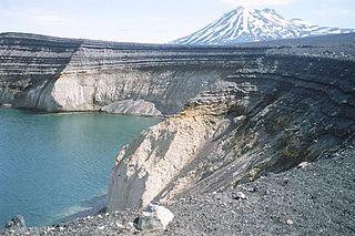
The Aleutian Range is a major mountain range located in southwest Alaska. It extends from Chakachamna Lake to Unimak Island, which is at the tip of the Alaska Peninsula. It includes all of the mountains of the Peninsula. The Aleutian Range is special because of its large number of active volcanoes, which are also part of the larger Aleutian Arc. The mainland part of the range is about 600 miles (1000 km) long. The Aleutian Islands are (geologically) a partially submerged western extension of the range that stretches for another 1,600 km (1000 mi). However the official designation "Aleutian Range" includes only the mainland peaks and the peaks on Unimak Island. The range is almost entirely roadless wilderness. Katmai National Park and Preserve, a large national park within the range, must be reached by boat or plane.
The Chugach Mountains of southern Alaska are the northernmost of the several mountain ranges that make up the Pacific Coast Ranges of the western edge of North America. The range is about 250 miles (402 km) long and 60 miles (97 km) wide, and extends from the Knik and Turnagain Arms of the Cook Inlet on the west to Bering Glacier, Tana Glacier, and the Tana River on the east. It is bounded on the north by the Matanuska, Copper, and Chitina rivers. The highest point of the Chugach Mountains is Mount Marcus Baker, at 13,094 feet (3,991 m), but with an average elevation of 4,006 feet (1,221 m), most of its summits are not especially high. Even so, its position along the Gulf of Alaska ensures more snowfall in the Chugach than anywhere else in the world, an annual average of over 1500 cm (800 in).

Denali National Park and Preserve, formerly known as Mount McKinley National Park, is an American national park and preserve located in Interior Alaska, centered on Denali, the highest mountain in North America. The park and contiguous preserve encompass 6,045,153 acres which is larger than the state of New Hampshire. On December 2, 1980, 2,146,580-acre Denali Wilderness was established within the park. Denali's landscape is a mix of forest at the lowest elevations, including deciduous taiga, with tundra at middle elevations, and glaciers, snow, and bare rock at the highest elevations. The longest glacier is the Kahiltna Glacier. Wintertime activities include dog sledding, cross-country skiing, and snowmobiling. The park received 594,660 recreational visitors in 2018.

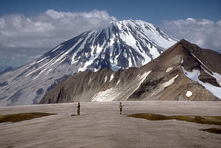
Katmai National Park and Preserve is an American national park and preserve in southwest Alaska, notable for the Valley of Ten Thousand Smokes and for its brown bears. The park and preserve encompass 4,093,077 acres, which is between the sizes of Connecticut and New Jersey. Most of the national park is a designated wilderness area. The park is named after Mount Katmai, its centerpiece stratovolcano. The park is located on the Alaska Peninsula, across from Kodiak Island, with headquarters in nearby King Salmon, about 290 miles (470 km) southwest of Anchorage. The area was first designated a national monument in 1918 to protect the area around the major 1912 volcanic eruption of Novarupta, which formed the Valley of Ten Thousand Smokes, a 40-square-mile (100 km2), 100-to-700-foot-deep pyroclastic flow. The park includes as many as 18 individual volcanoes, seven of which have been active since 1900.

Mount Saint Elias, the second-highest mountain in both Canada and the United States, stands on the Yukon and Alaska border about 26 miles (42 km) southwest of Mount Logan, the highest mountain in Canada. The Canadian side of Mount Saint Elias forms part of Kluane National Park and Reserve, while the U.S. side of the mountain is located within Wrangell-St. Elias National Park and Preserve.

Mount Fairweather, is the highest mountain in the Canadian province of British Columbia, with an elevation of 4,653 metres (15,266 ft). It is located 20 km (12 mi) east of the Pacific Ocean on the border of Alaska, United States and western British Columbia, Canada. Most of the mountain lies within Glacier Bay National Park and Preserve in the City and Borough of Yakutat, Alaska (USA), though the summit borders Tatshenshini-Alsek Provincial Park, British Columbia (Canada). It is also designated as Boundary Peak 164 or as US/Canada Boundary Point #164.

Mount Vancouver is the 15th highest mountain in North America. Its southern side lies in Glacier Bay National Park and Preserve at the top of the Alaska panhandle, while its northern side is in Kluane National Park and Reserve in the southwestern corner of Yukon, Canada. Mount Vancouver has three summits: north, middle, and south, with the middle summit being the lowest. The south summit, Good Neighbor Peak at 4,785 m (15,699 ft), straddles the international border while the north summit is slightly higher at 4,812 m (15,787 ft).
Mount Hubbard is one of the major mountains of the Saint Elias Range. It is located on the Alaska/Yukon border; the Canadian side is within Kluane National Park and Reserve, and the American side is part of Wrangell–St. Elias National Park. The mountain was named in 1890 by U.S. Geological Survey geologist Israel Russell after Gardiner Greene Hubbard, first president of the National Geographic Society, which had co-sponsored Russell's expedition.

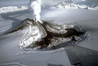
Redoubt Volcano, or Mount Redoubt, is an active stratovolcano in the largely volcanic Aleutian Range of the U.S. state of Alaska. Located at the head of the Chigmit Mountains subrange in Lake Clark National Park and Preserve, the mountain is just west of Cook Inlet, in the Kenai Peninsula Borough about 110 miles (180 km) southwest of Anchorage. At 10,197 feet (3,108 m), in just over 5 miles (8 km) Mount Redoubt attains 9,150 feet (2,700 m) of prominence over its surrounding terrain. It is the highest summit in the Aleutian Range. In 1976, Redoubt Volcano was designated as a National Natural Landmark by the National Park Service.
Mount Griggs, formerly known as Knife Peak Volcano, is a stratovolcano, which lies 10 km behind the volcanic arc defined by other Katmai group volcanoes. Although no historic eruptions have been reported from Mount Griggs, vigorously active fumaroles persist in a summit crater and along the upper southwest flank. The fumaroles on the southwest flank are the hottest, and some of the flank fumaroles can roar so loudly that they can be heard from the valley floor. The slopes of Mount Griggs are heavily mantled by fallout from the 1912 eruption of Novarupta volcano. The summit consists of three concentric craters, the lowest and largest of which contains a recent summit cone topped by two craters. The volume of the volcanic edifice is estimated at about 25 cubic kilometers (6.0 cu mi). Isotopic analysis indicates that the source of Griggs' magma is distinct from the other Katmai volcanoes.
Mount Veniaminof is an active stratovolcano on the Alaska Peninsula. The mountain was named after Ioann Veniaminov (1797–1879), a Russian Orthodox missionary priest whose writings on the Aleut language and ethnology are still standard references. He is a saint of the Orthodox Church, known as Saint Innocent for the monastic name he used in later life.

Mount Vsevidof is a stratovolcano in the U.S. state of Alaska. Its summit is the highest point on Umnak Island, one of the eastern Aleutian Islands. Its symmetrical cone rises abruptly from its surroundings. The base of the volcano is around 10 km (6 mi) wide, steepening from about 15 degrees at 300 m (980 ft) altitude to around 30 degrees near the summit. Some glacial tongues have cut through narrow canyons up to 120 m (390 ft) deep, due to ice filling the crater and extending down the north and east flanks of the cone. Vsevidof's most recent eruption was caused by an earthquake on March 9, 1957. The mountain erupted on March 11, 1957, and the eruption ended the next day.

Mount Cleveland is a nearly symmetrical stratovolcano on the western end of Chuginadak Island, which is part of the Islands of Four Mountains just west of Umnak Island in the Fox Islands of the Aleutian Islands of Alaska. Mt. Cleveland is 5,675 ft (1,730 m) high, and one of the most active of the 75 or more volcanoes in the larger Aleutian Arc. Aleutian natives named the island after their fire goddess, Chuginadak, who they believed inhabited the volcano. In 1894 a team from the U.S. Coast and Geodetic Survey visited the island and gave Mount Cleveland its current name, after then-president Grover Cleveland.

Mount Hayes is the highest mountain in the eastern Alaska Range, in the U.S. state of Alaska. Despite not being a fourteener, it is one of the largest peaks in the United States in terms of rise above local terrain. For example, the Northeast Face rises 8,000 feet (2,440 m) in approximately 2 miles (3.2 km). This large vertical relief contributes to Mount Hayes being the 51st most topographically prominent peak in the world.

Mount Bona is one of the major mountains of the Saint Elias Mountains in eastern Alaska, and is the fifth-highest independent peak in the United States. It is either the tenth- or eleventh-highest peak in North America. Mount Bona and its adjacent neighbor Mount Churchill are both large ice-covered stratovolcanoes. Bona has the distinction of being the highest volcano in the United States and the fourth-highest in North America, outranked only by the three highest Mexican volcanoes, Pico de Orizaba, Popocatépetl, and Iztaccíhuatl. Its summit is a small stratovolcano on top of a high platform of sedimentary rocks.

Mount Bear is a high, glaciated peak in the Saint Elias Mountains of Alaska. It lies within Wrangell-Saint Elias National Park, about 4 miles (6.4 km) west of the Yukon border. The Barnard Glacier flows from its southwest slopes, while the Klutlan Glacier lies to the north. Its principal claim to fame is that it is a fourteener, and in fact one of the highest 20 peaks in the United States.
References
- 1 2 "Sergief - Introduction". avo.alaska.edu. Retrieved 2019-08-22.
- ↑ "Mount Sergief". Geographic Names Information System . United States Geological Survey . Retrieved 2019-09-24.
- ↑ "Sergief". Global Volcanism Program . Smithsonian Institution . Retrieved 2021-06-28.
| | This article about a location in the Aleutians West Census Area, Alaska is a stub. You can help Wikipedia by expanding it. |