
Lassen Volcanic National Park is an American national park in northeastern California. The dominant feature of the park is Lassen Peak, the largest plug dome volcano in the world and the southernmost volcano in the Cascade Range. Lassen Volcanic National Park is one of the few areas in the world where all four types of volcanoes can be found: plug dome, shield, cinder cone, and stratovolcano.

The Lassen volcanic area presents a geological record of sedimentation and volcanic activity in and around Lassen Volcanic National Park in Northern California, U.S. The park is located in the southernmost part of the Cascade Mountain Range in the Pacific Northwest region of the United States. Pacific Oceanic tectonic plates have plunged below the North American Plate in this part of North America for hundreds of millions of years. Heat and molten rock from these subducting plates has fed scores of volcanoes in California, Oregon, Washington and British Columbia over at least the past 30 million years, including these in the Lassen volcanic areas.

Lassen Peak, commonly referred to as Mount Lassen, is a 10,457 ft (3,187 m) lava dome volcano in Lassen Volcanic National Park in Northern California. Located in the Shasta Cascade region above the northern Sacramento Valley, it is the southernmost active volcano in the Cascade Range of the Western United States, and part of the Cascade Volcanic Arc stretching from southwestern British Columbia to northern California. It supports many flora and fauna among its diverse habitats, which reach high elevations andare subject to frequent snowfall.

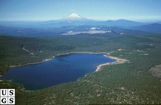
Chaos Crags is the youngest group of lava domes in Lassen Volcanic National Park, California. They formed as six dacite domes 1,100-1,000 years ago, one dome collapsing during an explosive eruption about 70 years later. The eruptions at the Chaos Crags mark one of just three instances of Holocene activity within the Lassen volcanic center. The cluster of domes is located north of Lassen Peak and form part of the southernmost segment of the Cascade Range in Northern California. Each year, a lake forms at the base of the Crags, and typically dries by the end of the summer season.

Cinder Cone is a cinder cone volcano in Lassen Volcanic National Park within the United States. It is located about 10 mi (16 km) northeast of Lassen Peak and provides an excellent view of Brokeoff Mountain, Lassen Peak, and Chaos Crags.

Mount Jefferson is a stratovolcano in the Cascade Volcanic Arc, part of the Cascade Range in the U.S. state of Oregon. The second highest mountain in Oregon, it is situated within Linn County, Jefferson County, and Marion County and forms part of the Mount Jefferson Wilderness. Due to the ruggedness of its surroundings, the mountain is one of the hardest volcanoes to reach in the Cascades. It is also a popular tourist destination despite its remoteness, with recreational activities including hiking, backpacking, mountaineering, and photography. Vegetation at Mount Jefferson is dominated by Douglas fir, silver fir, mountain hemlock, ponderosa pine, lodgepole pine, and several cedar species. Carnivores, insectivores, bats, rodents, deer, birds, and various other species inhabit the area.

Mount Mazama is a complex volcano in the western U.S. state of Oregon, in a segment of the Cascade Volcanic Arc and Cascade Range. Most of the mountain collapsed following a major eruption approximately 7,700 years ago. The volcano is in Klamath County, in the southern Cascades, 60 miles (97 km) north of the Oregon–California border. Its collapse, due to the eruption of magma emptying the underlying magma chamber, formed a caldera that holds Crater Lake. Mount Mazama originally had an elevation of 12,000 feet (3,700 m), but following its climactic eruption this was reduced to 8,157 feet (2,486 m). Crater Lake is 1,943 feet (592 m) deep, the deepest freshwater body in the U.S. and the second deepest in North America after Great Slave Lake in Canada.
Medicine Lake Volcano is a large shield volcano in northeastern California about 30 mi (50 km) northeast of Mount Shasta. The volcano is located in a zone of east-west crustal extension east of the main axis of the Cascade Volcanic Arc and the Cascade Range. The 0.6 mi (1 km) thick shield is 22 mi (35 km) from east to west and 28 to 31 mi from north to south, and covers more than 770 sq mi (2,000 km2). The underlying rock has downwarped by 0.3 mi (0.5 km) under the center of the volcano. The volcano is primarily composed of basalt and basaltic andesite lava flows, and has a 4.3 by 7.5 mi caldera at the center.

The Soufrière Hills are an active, complex stratovolcano with many lava domes forming its summit on the Caribbean island of Montserrat. After a long period of dormancy, the Soufrière Hills volcano became active in 1995 and has continued to erupt ever since. Its eruptions have rendered more than half of Montserrat uninhabitable, destroying the capital city, Plymouth, and causing widespread evacuations: about two-thirds of the population have left the island. Chances Peak in the Soufrière Hills was the highest summit on Montserrat until the mid-1990s, but it has since been eclipsed by various rising and falling volcanic domes during the recent volcanic activity.

The Anahim Volcanic Belt (AVB) is a west–east trending chain of volcanoes and related magmatic features in British Columbia, Canada. It extends from Athlone Island on the Central Coast, running eastward through the strongly uplifted and deeply dissected Coast Mountains to near the community of Nazko on the Interior Plateau. The AVB is delineated as three west-to-east segments that differ in age and structure. A wide variety of igneous rocks with differing compositions occur throughout these segments, comprising landforms such as volcanic cones, volcanic plugs, lava domes, shield volcanoes and intrusions.

The Garibaldi Volcanic Belt is a northwest–southeast trending volcanic chain in the Pacific Ranges of the Coast Mountains that extends from Watts Point in the south to the Ha-Iltzuk Icefield in the north. This chain of volcanoes is located in southwestern British Columbia, Canada. It forms the northernmost segment of the Cascade Volcanic Arc, which includes Mount St. Helens and Mount Baker. Most volcanoes of the Garibaldi chain are dormant stratovolcanoes and subglacial volcanoes that have been eroded by glacial ice. Less common volcanic landforms include cinder cones, volcanic plugs, lava domes and calderas. These diverse formations were created by different styles of volcanic activity, including Peléan and Plinian eruptions.

Goat Rocks is an extinct stratovolcano in the Cascade Range, located between Mount Rainier and Mount Adams in southern Washington, in the United States. Part of the Cascade Volcanoes, it was formed by the subduction of the Juan de Fuca Plate under the western edge of the North American Plate. The volcano was active from 3.2 million years ago until eruptions ceased between 1 and 0.5 million years ago. Throughout its complex eruptive history, volcanism shifted from silicic explosive eruptions to voluminous, mafic activity.
Yantarni Volcano is an andesitic stratovolcano in the U.S. state of Alaska. It is on the Alaska Peninsula, in the Aleutian Range, between Mount Aniakchak and Mount Chiginagak volcanoes. The volcano was not discovered until 1979 due to its remote location, lack of documented historic activity, and its rather modest summit elevation. The mountain was named after nearby Yantarni Bay, which in turn was named by Russian explorers after the abundance of yantar in the area.

The Mount Meager massif is a group of volcanic peaks in the Pacific Ranges of the Coast Mountains in southwestern British Columbia, Canada. Part of the Cascade Volcanic Arc of western North America, it is located 150 km (93 mi) north of Vancouver at the northern end of the Pemberton Valley and reaches a maximum elevation of 2,680 m (8,790 ft). The massif is capped by several eroded volcanic edifices, including lava domes, volcanic plugs and overlapping piles of lava flows; these form at least six major summits including Mount Meager which is the second highest of the massif.

The Cascade Volcanoes are a number of volcanoes in a volcanic arc in western North America, extending from southwestern British Columbia through Washington and Oregon to Northern California, a distance of well over 700 miles (1,100 km). The arc formed due to subduction along the Cascadia subduction zone. Although taking its name from the Cascade Range, this term is a geologic grouping rather than a geographic one, and the Cascade Volcanoes extend north into the Coast Mountains, past the Fraser River which is the northward limit of the Cascade Range proper.

The Twin Buttes are two volcanic cinder cones located in the Cascade Mountain Range in Shasta County, California. They are part of the Bidwell Spring chain and lie within a region that was active in the Quaternary. Formed during the Pleistocene between 25,000 and 15,000 years ago, the volcanoes erupted lava flows that coursed toward the Burney Mountain lava dome. These lava flows cover an area of 3.9 square miles (10.1 km2) and are made of basalt and dacite. The volcanoes also erupted cinder and volcanic ash that reached eastward.

The Silverthrone Caldera is a potentially active caldera complex in southwestern British Columbia, Canada, located over 350 kilometres (220 mi) northwest of the city of Vancouver and about 50 kilometres (31 mi) west of Mount Waddington in the Pacific Ranges of the Coast Mountains. The caldera is one of the largest of the few calderas in western Canada, measuring about 30 kilometres (19 mi) long (north-south) and 20 kilometres (12 mi) wide (east-west). Mount Silverthrone, an eroded lava dome on the caldera's northern flank that is 2,864 metres (9,396 ft) high, may be the highest volcano in Canada.

The Canadian Cascade Arc, also called the Canadian Cascades, is the Canadian segment of the North American Cascade Volcanic Arc. Located entirely within the Canadian province of British Columbia, it extends from the Cascade Mountains in the south to the Coast Mountains in the north. Specifically, the southern end of the Canadian Cascades begin at the Canada–United States border. However, the specific boundaries of the northern end are not precisely known and the geology in this part of the volcanic arc is poorly understood. It is widely accepted by geologists that the Canadian Cascade Arc extends through the Pacific Ranges of the Coast Mountains. However, others have expressed concern that the volcanic arc possibly extends further north into the Kitimat Ranges, another subdivision of the Coast Mountains, and even as far north as Haida Gwaii.

The Mount Cayley volcanic field (MCVF) is a remote volcanic zone on the South Coast of British Columbia, Canada, stretching 31 km (19 mi) from the Pemberton Icefield to the Squamish River. It forms a segment of the Garibaldi Volcanic Belt, the Canadian portion of the Cascade Volcanic Arc, which extends from Northern California to southwestern British Columbia. Most of the MCVF volcanoes were formed during periods of volcanism under sheets of glacial ice throughout the last glacial period. These subglacial eruptions formed steep, flat-topped volcanoes and subglacial lava domes, most of which have been entirely exposed by deglaciation. However, at least two volcanoes predate the last glacial period and both are highly eroded. The field gets its name from Mount Cayley, a volcanic peak located at the southern end of the Powder Mountain Icefield. This icefield covers much of the central portion of the volcanic field and is one of the several glacial fields in the Pacific Ranges of the Coast Mountains.
The Bridge River Vent is a volcanic crater in the Pacific Ranges of the Coast Mountains in southwestern British Columbia, Canada. It is located 51 km (32 mi) west of Bralorne on the northeastern flank of the Mount Meager massif. With an elevation of 1,524 m (5,000 ft), it lies on the steep northern face of Plinth Peak, a 2,677 m (8,783 ft) high volcanic peak comprising the northern portion of Meager. The vent rises above the western shoulder of the Pemberton Valley and represents the northernmost volcanic feature of the Mount Meager massif.


