
A natural arch, natural bridge, or rock arch is a natural rock formation where an arch has formed with an opening underneath. Natural arches commonly form where inland cliffs, coastal cliffs, fins or stacks are subject to erosion from the sea, rivers or weathering.

Khorasan, also called Traxiane during Hellenistic and Parthian times, was a province in north eastern Iran, but historically referred to a much larger area comprising the east and north-east of the Persian Empire. The name Khorāsān is Persian and means "where the sun arrives from". The name was first given to the eastern province of Persia during the Sasanian Empire and was used from the late middle ages in distinction to neighbouring Transoxiana. The province roughly encompassed the western half of the historical Greater Khorasan. The modern boundaries of the Iranian province of Khorasan were formally defined in the late nineteenth century and the province was divided into three separate administrative divisions in 2004.

Tabas, formerly Golshan, is a city in and capital of Tabas County, South Khorasan Province, Iran. At the 2011 census, its population was 35,150, in 9,903 families.
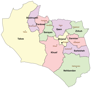
South Khorasan Province is a province located in eastern Iran. Birjand is the centre of the province. The other major cities are Ferdows, Tabas and Qaen. In 2014, it was placed in Region 5.

Razavi Khorasan Province is a province located in northeastern Iran. Mashhad is the center and capital of the province. Other cities are Quchan, Dargaz, Chenaran, Sarakhs, Fariman, Torbat-e Heydarieh, Torbat-e Jam, Salehabad, Taybad, Khaf, Roshtkhar, Kashmar, Rivash, Bardaskan, Nishapur, Sabzevar, Gonabad, Kalat. Razavi Khorasan is one of the three provinces that were created after the division of Khorasan Province in 2004. In 2014 it was placed in Region 5 with Mashhad as the location of the region's secretariat.

Whiteshell Provincial Park is a 2,721 km2 park centrally located in Canada in the province of Manitoba. It is found in the southeast region of the province along the Manitoba-Ontario boundary, approximately 130 km east of the city of Winnipeg. The park is located in the Canadian Shield region and has many rivers, remote lakes, boreal forest and bare granite ridges. It has rare archeological sites of petroforms on flat granite ridges. The park is used year-round for nature-oriented recreation activities.
Hole-in-the-Rock or Hole in the Rock may refer to:

Ferdows is a city and capital of Ferdows County, located in the north of South Khorasan Province in Iran. It is about 345 kilometres (214 mi) south of Mashhad and 200 km northwest of Birjand. At the 2011 census, its population was 28,695, in 8,749 families.
Ferdows County is a county in the north of South Khorasan Province in Iran. The capital of the county is Ferdows. Ferdows County has two cities Ferdows & Eslamiyeh. The population of this county is about 45,000. Ferdows County, which was formed in 1944, originally included a large area but its subdivisions have gradually become independent and now encompasses four counties. After dividing the Khorasan province into 3 provinces, Ferdows County was initially a part of Razavi Khorasan province, but was incorporated within the borders of South Khorasan Province in March 2007.
Tabas County is a county in South Khorasan Province in Iran. The capital of the county is Tabas. Tabas County was a part of Ferdows County until July 1960. At first, it was a part of the Khorasan province, but moved to Yazd Province in 2001. Finally it is moved to South Khorasan Province in 2013.
Ferdows Hot Spring or Ferdows Warm Spring is a hot mineral spring located about 20 km (12 mi) north of Ferdows in eastern Iran, near an inactive volcano. Its mineral water is useful in healing skin diseases and rheumatism.
Eslamiyeh is a city in the Central District of Ferdows County, in South Khorasan Province, Iran. At the 2016 census, its population was 7,108, in 2,193 families. Islamiyeh is located in about 3 kilometres (1.9 mi) northeast of Ferdows.
Ferdows is a city in South Khorasan Province in Iran

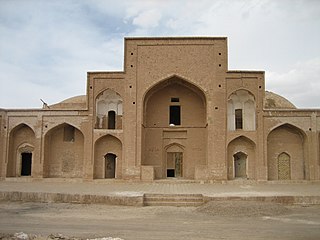
The Jāmeh Mosque of Ferdows is the grand, congregational mosque (Jāmeh) of Ferdows, South Khorasan Province, Iran. The mosque is located towards the southwest of city, in the center of the ancient city of Toon.
Ferdows Religious School is a historic school with octagonal design, located in the southwest of Ferdows city, in the center of the ancient city of Toon, in South Khorasan province, Iran.
Boshruyeh County is a county in South Khorasan Province in Iran. The center of the county is Boshruyeh. Boshruyeh County has two cities Boshruyeh & Eresk. Boshruyeh County used to belong to Ferdows County until November 2008. The population of Boshruyeh County is about 26,000

The Devils Garden of the Grand Staircase–Escalante National Monument (GSENM) in south central Utah, United States, is a protected area featuring hoodoos, natural arches and other sandstone formations. The United States Geological Survey (USGS) designated the name Devils Garden on December 31, 1979. The area is also known as the Devils Garden Outstanding Natural Area within the National Landscape Conservation System.
Yumbarra Conservation Park, formerly the Yumbarra National Park, is a protected area in the Australian state of South Australia located about 55 kilometres north of the town centre of Ceduna.

Ferdows Hole-in-the-Rock is a natural geological formation 35 km (22 mi) west of Ferdows, South Khorasan Province, Iran.
Polond Desert, also known as the Mozaffari Desert, is a desert located 40 kilometers West of Ferdows, South Khorasan Province, Iran.


