Munda, Solomon Islands

Last updated
Munda, Solomon Islands
Settlement
Munda Point Airfield.jpg
Munda Point Airfield in New Georgia seen from West - Central Solomons - 1943
Solomon Islands adm location map.svg
Red pog.svg
Munda, Solomon Islands
Coordinates: 8°19′37″S157°16′05″E / 8.327°S 157.26818°E / -8.327; 157.26818

Munda is the largest settlement on the island of New Georgia in the Western Province of Solomon Islands, and consists of a number of villages. It is located at the southwestern tip (called Munda Point) of the western end of New Georgia, and the large Roviana Lagoon is just offshore.

Contents

Munda Point was originally the site of a coconut plantation established by Englishman Norman Wheatley, and then owned by Australian Lesley Gill.

History

The Colonial Office had appointed Charles Morris Woodford as the Resident Commissioner in the Solomon Islands on 17 February 1897. He was directed to control the labour trade operating in the Solomon Island waters and to stop the illegal trade in firearms. [1] Arthur Mahaffy was appointed as the Deputy Commissioner to Woodford in January 1898. [2] In January 1900, Mahaffy established a government station at Gizo, as Woodford considered Mahaffy’s military training as making him suitable for the role of suppressing headhunting in New Georgia and neighbouring islands. [2] [3] Mahaffy had a force of twenty-five police armed with rifles. [4] The first target of this force was chief Ingava of the Roviana Lagoon who had been raiding Choiseul and Isabel and killing or enslaves hundreds of people. [4]

Mahaffy and the police officers under his command carried out a violent and ruthless suppression of headhunting, with his actions having the support of Woodford and the Western Pacific High Commission , who wanted to eradicate headhunting and complete a “pacification” of the western Solomon Islands. [2] Mahaffy seized and destroyed large war canoes (tomokos). One of which was used to transport the police officers. [4]

The Methodist Mission in the Western Province was established by Rev. John Frances Goldie in 1902. He dominated the mission and gained the loyalty of Solomon Islander members of his church. [5] The relationship with the colonial administrators of the British Solomon Island Protectorate were also fraught with difficulty, at this time due to Goldie's effective control over the Western Solomon Islands. [5] From 1927 to 1934 Dr Edward Sayers worked at the Methodist mission where he established a hospital at Munda and also at Gizo and Vella Lavella, and carried out fieldwork in the treatment of malaria. [6]

In November 1942, during World War II, the town became strategically important after Japanese forces built an airstrip (on the site of today's Munda Airport) to support Japanese forces fighting the Battle of Guadalcanal. A Japanese convoy put into Munda Point on 24 November 1942, and started construction under careful concealment from the air by means of rows of coconut palms suspended by cable. The airstrip was discovered by American planes on 3 December, and the first airstrikes were delivered by B-17 Flying Fortress bombers on 9 December. However, the Japanese were able to use Munda despite regular bombardment from both air and sea, and the Allies launched Operation Cartwheel in order to drive the Japanese out of the Solomons and ultimately eliminate the large Japanese base at Rabaul. The New Georgia Campaign was launched in late June, 1943 when mainly American but also Pacific Islander troops conducted the Landings on Rendova and several other amphibious operations throughout the New Georgia Group. The Allied forces spent July 1943 conducting the Drive on Munda Point, shelling and bombing Japanese forces in and around Munda Airfield, fighting off a large Japanese counterattack, and eventually closing in on Munda overland, capturing it on 4–5 August during the Battle of Munda Point. The heavy fighting left thousands dead on both sides and many more wounded.

Transport

Boats are the main method of coastal and inter-island transport.

The airstrip from World War II was later converted into Munda Airport and is used commercially for daily flights land from Honiara, Setghe and Gizo, including services on Solomon Airlines. [7]

Geography

Lambete, the largest village in Munda, today consists of a number of shops, a branch of the Bank of South Pacific (BSP), a post office, a telecommunications centre, a bakery, accommodations, the airstrip and a small port.

Climate

Climate data for Munda, Solomon Islands
MonthJanFebMarAprMayJunJulAugSepOctNovDecYear
Record high °C (°F)33.3
(91.9)
33.9
(93.0)
33.9
(93.0)
33.9
(93.0)
32.8
(91.0)
34.4
(93.9)
33.3
(91.9)
31.7
(89.1)
32.8
(91.0)
33.3
(91.9)
33.3
(91.9)
33.9
(93.0)
34.4
(93.9)
Mean daily maximum °C (°F)30.9
(87.6)
30.7
(87.3)
30.8
(87.4)
30.7
(87.3)
30.7
(87.3)
30.2
(86.4)
29.4
(84.9)
29.5
(85.1)
30.1
(86.2)
30.6
(87.1)
31.0
(87.8)
31.1
(88.0)
30.4
(86.7)
Daily mean °C (°F)27.5
(81.5)
27.4
(81.3)
27.4
(81.3)
27.4
(81.3)
27.3
(81.1)
26.9
(80.4)
26.4
(79.5)
26.3
(79.3)
26.8
(80.2)
27.2
(81.0)
27.4
(81.3)
27.6
(81.7)
27.2
(81.0)
Mean daily minimum °C (°F)23.8
(74.8)
23.8
(74.8)
23.8
(74.8)
23.7
(74.7)
23.7
(74.7)
23.4
(74.1)
23.2
(73.8)
23.3
(73.9)
23.3
(73.9)
23.5
(74.3)
23.7
(74.7)
23.9
(75.0)
23.6
(74.5)
Record low °C (°F)21.1
(70.0)
21.1
(70.0)
21.1
(70.0)
21.1
(70.0)
20.6
(69.1)
20.0
(68.0)
20.0
(68.0)
15.6
(60.1)
19.4
(66.9)
18.3
(64.9)
20.6
(69.1)
21.1
(70.0)
15.6
(60.1)
Average precipitation days (≥ 0.1 mm)24.623.124.823.324.022.925.423.722.222.621.323.4281.3
Average relative humidity (%) (at 14:00)76777677767577767575757576
Source: Deutscher Wetterdienst [8]

See also

Related Research Articles

<span class="mw-page-title-main">History of Solomon Islands</span>

Solomon Islands is a sovereign state in the Melanesia subregion of Oceania in the western Pacific Ocean. This page is about the history of the nation state rather than the broader geographical area of the Solomon Islands archipelago, which covers both Solomon Islands and Bougainville Island, a province of Papua New Guinea. For the history of the archipelago not covered here refer to the former administration of the British Solomon Islands Protectorate, the North Solomon Islands and the History of Bougainville.

<span class="mw-page-title-main">New Georgia Islands</span> Island group

The New Georgia Islands are part of the Western Province of Solomon Islands. They are located to the northwest of Guadalcanal. The larger islands are mountainous and covered in rain forest. The main islands are New Georgia, Vella Lavella, Kolombangara, Ghizo, Vangunu, Rendova and Tetepare. They are surrounded by coral reefs and include the Marovo Lagoon.

<span class="mw-page-title-main">New Georgia</span> Largest of the islands in Western Province, Solomon Islands

New Georgia, with an area of 2,037 km2 (786 sq mi), is the largest of the islands in Western Province, Solomon Islands, and the 224th-largest island in the world. Since July 1978, the island has been part of the independent state of Solomon Islands.

<span class="mw-page-title-main">Kolombangara</span> One of the Solomon Islands in the south-west Pacific

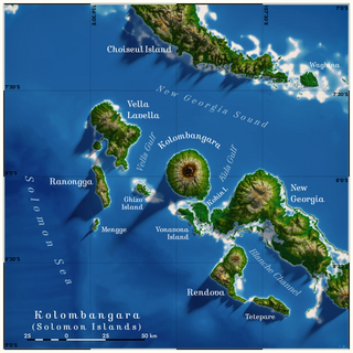
Kolombangara is an island in the New Georgia Islands group of the nation state of Solomon Islands in the southwestern Pacific Ocean. The name is from a local language, a rough translation of its meaning is "Water Lord" with approximately 80 rivers and streams running down its flanks.

<span class="mw-page-title-main">Western Province (Solomon Islands)</span> Province in Gizo, Solomon Islands

Western Province is the largest of the nine provinces of Solomon Islands. The area is renowned for its beautiful tropical islands, excellent diving and snorkelling, coral reefs and World War II wrecks, ecotourism lodges, and head-hunting shrines. The province contains many small lagoons and most of the country's tourist trade outside Honiara.

Bairoko Harbor is situated along the northwestern shore of the island of New Georgia in the Solomon Islands.

<span class="mw-page-title-main">British Solomon Islands</span> 1893–1978 British protectorate in Oceania

The British Solomon Islands Protectorate was first established in June 1893, when Captain Herbert Gibson of HMS Curacoa declared the southern Solomon Islands a British protectorate.

<span class="mw-page-title-main">Gizo, Solomon Islands</span> Town in Western Province, Solomon Islands

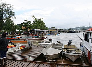
Gizo is the capital of the Western Province in Solomon Islands. With a population of 7,177, it is the third largest town in the country. It is situated on Ghizo Island approximately 380 kilometres west-northwest of the capital, Honiara, and is just southwest of the larger island of Kolombangara.

<span class="mw-page-title-main">Rendova Island</span>

Rendova is an island in Western Province, in the independent nation of Solomon Islands, in the South Pacific, east of Papua New Guinea.

<span class="mw-page-title-main">Arundel Island</span> Island in the Solomon Islands

Arundel Island is an island of the New Georgia Islands archipelago in the Western Province of Solomon Islands. Its indigenous names are Kohinggo and Ndokulu.

Munda International Airport is an international airport adjacent to the town of Munda, Western Province in Solomon Islands.

Charles Morris Woodford was a British naturalist and government minister active in the Solomon Islands. He became the first Resident Commissioner of the Solomon Islands Protectorate, serving from 1896 until 1915.

<span class="mw-page-title-main">Drive on Munda Point</span> Battle of the New Georgia campaign during World War II

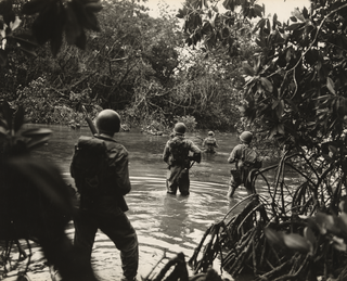
The Drive on Munda Point was an offensive by mainly United States Army forces against Imperial Japanese forces on New Georgia in the Solomon Islands from 2–17 July 1943. The Japanese forces, mainly from the Imperial Japanese Army, were guarding an airfield at Munda Point on the western coast of the island that the U.S. wished to capture as one of the key objectives of the New Georgia campaign. After landing around Zanana on 2 July from Rendova, U.S. troops began a westward advance towards the airfield at Munda. Held up by difficult terrain and stubborn Japanese defense, elements of three U.S. regiments advanced slowly along the Munda trail over the course of two weeks. The slow progress resulted in a reorganization of the U.S. forces assigned to the drive, and preparations were made for a corps-level offensive, but before this could be launched, the Japanese launched a counterattack on 17 July.

Kiambe is a small island in Western Province, in the independent nation of Solomon Islands.

<span class="mw-page-title-main">Edward Sayers (parasitologist)</span> New Zealand doctor (1902–1985)

Sir Edward George Sayers was a New Zealand medical doctor, parasitologist, Methodist missionary, military medical administrator, consultant physician and, from 1958 to 1968, Dean of the University of Otago, School of Medicine. Having trained as a doctor, from 1927 to 1934 he worked at the Methodist mission in the Solomon Islands where he carried out fieldwork in the treatment of malaria. The significance of this work became apparent when Sayers used his knowledge to reduce deaths of American, Australia and New Zealand military forces during the invasion of Pacific Islands during World War II. He served as a doctor with the 2nd Division 2 NZEF during 1941–42 in Greece and North Africa. In 1942 he was transferred to the Pacific to serve with the 3rd Division, 2 NZEF IP.

The Kalikoqu are an ethnic Melanesian tribe who are concentrated in the New Georgia island of the Solomon Islands. Prior to European colonization, they resided in the eastern side of the western Roviana lagoon and established the concept of the right to property by interlinking it with marriage. Before, during and after the British Empire's establishment of the Solomon Islands Protectorate in the late Victorian era, the Kalikoqu were greatly expanded by neighboring Melanesian tribes immigrating to the Solomon Islands interior.

<span class="mw-page-title-main">Tomako</span> Solomon Islander war canoe

Tomako or tomoko is a large war canoe from the Solomon Islands. The name "tomako" is used in New Georgia in the Roviana language. It is also known as magoru in Marovo, niabara in Vella Lavella, mon in Bougainville, ora in Makira, and iola or ola in Malaita and Ulawa. Tomako were narrow and usually between 12 and 18 m in length. They did not possess outriggers or sails and were propelled solely by paddling. They were built by fitting planks edge-to-edge which are then "sewn" together and caulked with a paste made from the nut of the tree Parinarium laurinum. They could carry 30 to 50 warriors, and were used in raiding expeditions for slaves or for headhunting. They were characteristically crescent-shaped, with sharply upturned prows and sterns that were decorated with fringes of cowrie shells, nautilus shells, and mother-of-pearl, as well as intricate carvings. These carvings are usually of spirit animals or warriors like the kesoko and Tiolo. The body is commonly blackened to contrast with the decorations.

<span class="mw-page-title-main">Battle of Arundel Island</span> Battle of the New Georgia campaign during World War II

The Battle of Arundel Island was fought from 27 August – 21 September 1943, primarily between United States Army and Imperial Japanese Army forces on Arundel Island during the New Georgia campaign in the Pacific War. The battle took place towards the end of the campaign after the capture of Munda airfield and mopping up operations in western New Georgia had resulted in the Japanese evacuation of mainland New Georgia. The US high command decided to occupy the island so that it could be used as a base for artillery to fire on the main Japanese troop concentration on Kolombangara.

John Francis Goldie founded the Methodist Mission in New Georgia Islands, which are part of the Solomon Islands. He was chairman of the Solomon Island District of the Methodist Mission from 1902 until his retirement in 1951.

Arthur William Mahaffy O.B.E. was a colonial administrator who served in the Gilbert and Ellice Islands Protectorate, the British Solomon Islands Protectorate, the Colony of Fiji, the Anglo-French Condominium of the New Hebrides, with his final post being the Administrator of Dominica.

References

  1. Coates, Austin (1970). Western Pacific Islands. London: Her Majesty's Stationery Office. p. 228. ISBN   978-0118804288.
  2. 1 2 3 Lawrence, David Russell (October 2014). "Chapter 7 Expansion of the Protectorate 1898–1900" (PDF). The Naturalist and his "Beautiful Islands": Charles Morris Woodford in the Western Pacific. ANU Press. pp. 198–206. doi: 10.22459/NBI.10.2014 . ISBN   9781925022032.
  3. Coates, Austin (1970). Western Pacific Islands. London: Her Majesty's Stationery Office. p. 229. ISBN   978-0118804288.
  4. 1 2 3 "Mahaffy, Arthur (1869 - 1919)". Solomon Islands Historical Encyclopaedia 1893-1978. 2003. Retrieved 24 March 2024.
  5. 1 2 Dr. Debra McDougall (2008). "Religious institutions as Alternative Structures in post-conflict Solomon Islands: Cases from Western Province". For State, Society and Governance in Melanesia Discussion Paper Series, 08/05, Australian National University. Archived from the original on 18 September 2014. Retrieved 4 Oct 2011.
  6. Sayers , E. G. (1943) Malaria in the South Pacific with Special Reference to the Solomon Islands. New Zealand Government Printing Office
  7. "Domestic Routes Map | Solomon Islands Flights | Solomon Airlines".
  8. "Klimatafel von Munda / Insel New Georgia / Salomonen" (PDF). Baseline climate means (1961-1990) from stations all over the world (in German). Deutscher Wetterdienst. Retrieved 23 July 2017.

8°19′41″S157°16′15″E / 8.32806°S 157.27083°E / -8.32806; 157.27083