Musoma

Last updated
Musoma
Jiji la Musoma
Musoma Aerial View.jpg
Tanzania location map.svg
Red pog.svg
Musoma
Location in Tanzania
Coordinates: 01°30′00″S33°48′00″E / 1.50000°S 33.80000°E / -1.50000; 33.80000
CountryFlag of Tanzania.svg  Tanzania
Region Mara Region
District Musoma Urban District
Government
  TypeMayor
Area
  Total25.53 sq mi (66.13 km2)
Elevation
3,720 ft (1,134 m)
Population
 (2022 Census) [1]
  Total164,172
Time zone UTC+3 (East Africa Time)
Website www.mara.go.tz
Mkendo Road, the main street through Musoma Musoma-Mkendo-Road-2012.JPG
Mkendo Road, the main street through Musoma

Musoma is a city in the east shore of Lake Victoria of Tanzania. It is the capital of Mara Region, one of the administrative Regions of Tanzania. It also serves as the administrative centre of Musoma Rural District and Musoma Urban District.

Contents

Location

The city sits on the eastern edge of Lake Victoria, close to the International borders of Tanzania with Kenya and Uganda. Musoma is located approximately 60 kilometres (37 mi), directly south of the geographical point where the borders of the three East African countries intersect. The town is located approximately 225 kilometres (140 mi), by road, northeast of Mwanza, the nearest large city. [2] Musoma lies approximately 480 kilometres (300 mi), by road, northwest of Arusha, the location of the headquarters of the East African Community. [3] The coordinates of Musoma are:1° 30' 0.00"S, 33° 48' 0.00"E (Latitude:-1.5000; Longitude:33.8000).

History and Etymology

Small shops near the bus station. Musoma Busbahnhof1.jpg
Small shops near the bus station.

The name Musoma comes from the word Omusoma which means, a spit . The name refers to Musoma's many spits pointing into the surrounding Lake Victoria.

Among the current resident ethnic groups of Mara, the site that later developed into the town of Musoma was first settled by the Kurya subtribe of Abhakabhwa, commonly called Wakabwa. They also gave the name to the location. Hence, Musoma originates from the Kabwa word 'Omusoma', which actually means a piece of land that protrudes into the Lake, essentially, a peninsula. All the kingdoms in Mara, which are actually sub-kingdoms of people with a common ancestry use the word 'Omusoma' (for the Wakabwa, as well as the Wajita and the closely related sub tribes of Wakwaya, Waruri, Wakara, and Wakerewe) and 'Omosoma' (for the many Kurianic sub-tribes such as Abhakerobha - commonly called Wakiroba; Wasimbiti, Wakenye, nk.). The full name is actually "Omosoma (or 'Omusoma') ghwa Nyabhamba".

Musoma was hotly contested and witnessed many intra-ethnic wars, particularly between the Wakabwa and their kins, the Wakiroba - who were second to arrive in the location after the Wakabwa. The Wakabwa brought in their allies, the non-Bantu Luo and were on the tip of winning the war. The Wakiroba turned to their allies, the Wakwaya but were still heading for defeat. Seeing the situation worsen, the Wakwaya and Wakiroba sought support from the Germans, who at that time had arrived in Mwanza but not yet conquered present day Mara. It was under severe attacks by the German Canons that the Wakabwa and their allies the Luo could be defeated and chased away from the area. A legacy of this war are several mass graves just outside Musoma, particularly in Nyabhange (now commonly called Nyabangi) in Kiroba Land. From that time on, the Wakiroba and Wakwaya became resident neighbors of Musoma, dominating its population for a very long time. Now Musoma is significantly cosmopolitan.

The first headquarters of the occupying Germans was established in Nyabangi, but - just like in the case of Bagamoyo on the Indian Ocean Coast, which was the first Capital of German East Africa - it was abandoned due to shallow waters that made an unsuitable location for a harbour. Musoma became the new capital. Today, the old German 'Boma' is testimony to this history of Musoma.

Geography

The southern shore of Lake Victoria in Musoma. Musoma Seeufer.jpg
The southern shore of Lake Victoria in Musoma.

The city is situated in a heavily indented bay. The Mara River, after which the administrative region of Mara Region is named, flows into Lake Victoria, in nearby Kirumi in Kiroba/Simbiti Land.

Climate

Musoma has a tropical savanna climate (Köppen Aw).

Climate data for Musoma (1991–2020)
MonthJanFebMarAprMayJunJulAugSepOctNovDecYear
Mean daily maximum °C (°F)28.5
(83.3)
29.3
(84.7)
29.1
(84.4)
28.6
(83.5)
28.6
(83.5)
28.6
(83.5)
28.7
(83.7)
28.9
(84.0)
29.2
(84.6)
29.4
(84.9)
28.5
(83.3)
28.2
(82.8)
28.8
(83.8)
Mean daily minimum °C (°F)18.4
(65.1)
18.7
(65.7)
18.7
(65.7)
18.4
(65.1)
18.0
(64.4)
17.4
(63.3)
16.7
(62.1)
17.4
(63.3)
18.4
(65.1)
18.7
(65.7)
18.5
(65.3)
18.4
(65.1)
18.1
(64.6)
Average rainfall mm (inches)61.5
(2.42)
58.2
(2.29)
147.3
(5.80)
162.6
(6.40)
108.1
(4.26)
28.7
(1.13)
12.9
(0.51)
21.1
(0.83)
28.7
(1.13)
66.7
(2.63)
119.1
(4.69)
88.8
(3.50)
903.7
(35.58)
Average rainy days (≥ 1.0 mm)7.76.110.914.210.73.41.52.54.37.611.79.890.4
Source: NOAA [4]

Notable persons from Musoma and Mara

Population

The 2002 national census put the population of Musoma at 104,851. [5] The 2012 Census showed a population of 134,327. [6]

People

Tanzania's founding leader, President Julius Kambarage Nyerere and Tanzania's former Prime Minister, Joseph Sinde Warioba, both attended Mwisenge Middle School in Musoma. The politician and ambassador Paul Bomani was born in Musoma in 1925. [7]

Musoma is home to the Wakiroba subtribe of the Kuria, and to the Kwaya subtribe that is closely related with Wajita, Waruri, Wasimbiti and Wakara. It is also home to the Wajita, Waruri, Wakara, all Kuria sub tribes (including the Wazanaki and Waikizu), and the Luo, among others. Over time, several ethnic groups from other parts of Tanzania and East Africa have chosen Musoma as their home, such as Somalis. Altogether more than 12 ethnic groups live in Musoma.

Economic activity

Ferry M.V. Musoma in the port of Musoma town. M.V. Musoma.JPG
Ferry M.V. Musoma in the port of Musoma town.

Many people in Musoma are engaged in fishing Nile perch from the lake, or own and run small businesses, or are simply employed in the public sector or private sector (both formal and informal). Those living in Musoma Rural District are also Pastoralists, and many grow cotton as a cash crop. There are plans underway to construct a railway line from the port of Tanga on the Indian Ocean, through Arusha, around Serengeti National Park to Musoma. From Musoma, goods will be transferred to barges and transported over Lake Victoria, to Port Bell in Kampala. The project is a joint venture between the governments of Tanzania and Uganda and is expected to cost about US$1.9 billion. [8] The city is also served by Musoma Airport.

Sport

The Tanzanian Premier League football club Biashara United is based in Musoma.

See also

Related Research Articles

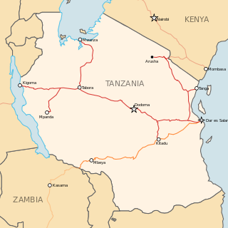
Transport in Tanzania includes road, rail, air and maritime networks. The road network is 86,472 kilometres (53,731 mi) long, of which 12,786 kilometres (7,945 mi) is classified as trunk road and 21,105 kilometres (13,114 mi) as regional road. The rail network consists of 3,682 kilometres (2,288 mi) of track. Commuter rail service is in Dar es Salaam only. There are 28 airports, with Julius Nyerere International being the largest and the busiest. Ferries connect Mainland Tanzania with the islands of Zanzibar. Several other ferries are active on the countries' rivers and lakes.

<span class="mw-page-title-main">Mwanza</span> City of Mwanza Region in Tanzania

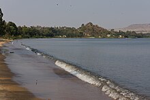
Mwanza City, also known as Rock City to the residents, is a port city and capital of Mwanza Region on the southern shore of Lake Victoria in north-western Tanzania. With an urban population of 1,311,000 in 2023, it is Tanzania's second largest city, after Dar es Salaam. It is also the second largest city in the Lake Victoria basin after Kampala, Uganda and ahead of Kisumu, Kenya at least in population size. Within the East African community, Mwanza city is the fifth largest city after Dar, Nairobi, Mombasa, and Kampala. It is slightly ahead of Kigali, Kisumu, and Bujumbura in the population of city proper limits. Mwanza city is also the capital city of Mwanza Region, and is administratively divided into two municipal districts within that Region - Ilemela and Nyamagana.

<span class="mw-page-title-main">Mara Region</span> Region of Tanzania

Mara Region is one of Tanzania's 31 administrative regions. The region covers an area of 21,760 km2 (8,400 sq mi). The region is comparable in size to the combined land area of the nation state of El Salvador. The neighboring regions are Mwanza Region and Simiyu Region, Arusha Region, and Kagera Region. The Mara Region borders Kenya .The regional capital is the municipality of Musoma. Mara Region is known for being the home of Serengeti National Park, a UNESCO World Heritage site and also the birth place of Tanzania's founding father Julius Nyerere. Under British colonial occupation, the Mara Region was a district called the Lake Province, which became the Lake Region after independence in 1961.

<span class="mw-page-title-main">Bunda District</span> District in Mara Region, Tanzania

Bunda is one of the seven districts of Mara Region in the United Republic of Tanzania, East Africa. It is bordered to the north by the Musoma Rural District and Butiama District, to the east by Serengeti District, to the south by Bariadi District and Busega District, and to the west by Lake Victoria. The district administration town is also called Bunda, located on the north-south trans-national all tarmac highway from Kenya to Zambia via Tarime and the lakeside municipalities of Musoma, Mwanza, and thereon to Mbeya in southern Tanzania. The district has four divisions: Kenkombyo, Nansimo, Serengeti and Chamuriho.

<span class="mw-page-title-main">Mwanza Region</span> Region of Tanzania

Mwanza Region is one of Tanzania's 31 administrative regions. The region covers a land area of 25,233 km2 (9,743 sq mi). The region is comparable in size to the combined land area of the nation state of North Macedonia. Mwanza Region is bordered to the north through Lake Victoria by the Kagera Region and Mara Region, to the east by Simiyu Region, to the south by the Shinyanga Region and to the west by Geita Region. The regional capital is the city of Mwanza. According to the 2022 national census, the region had a population of 3,699,872 and national census of 2012 had 2,772,509. Mwanza Region is the second region with high population in Tanzania after Dar es Salaam Region.

<span class="mw-page-title-main">Serengeti District</span> District in Mara Region, Tanzania

Serengeti District is one of the seven districts of Mara Region of Tanzania. Its administrative centre is the town of Mugumu. It is home to part of the world-famous Serengeti National Park a UNESCO World Heritage Site and contains one of the western gates to the park.

<span class="mw-page-title-main">Tarime District</span> District in Mara Region, Tanzania

Tarime District is one of the seven districts of the Mara Region of Tanzania, East Africa. It was previously known as the "North Mara District". Its district capital is Tarime town. It is bordered from the north to east by the Kenyan districts of Migori, Trans Mara and Kuria East and West Districts, and to the east by the Maasai Mara game reserve. To the south, it is bordered across the Mara River by the Serengeti and Butiama districts, and to the west by Rorya District.

<span class="mw-page-title-main">Musoma Rural District</span> District in Mara Region, Tanzania

Musoma Rural District is one of the 9 districts of Mara Region of Tanzania. Mara region has the following Districts councils: Musoma district council, Rorya district council, Tarime rural, Tarime town council, Butiama, Serengeti, Bunda rural council, Bunda town Council and Musomal Municipal council. Its administrative centre is the town of Musoma. The district is bordered to the east by Butiama District, to the south by Bunda District and to the west and north by Lake Victoria.

<span class="mw-page-title-main">Catholic Church in Tanzania</span>

The Catholic Church in Tanzania is part of the worldwide Catholic Church, under the spiritual leadership of the Pope in Rome.

<span class="mw-page-title-main">Kuria people</span> Ethnic group from Mara Region of Tanzania

The Kuria people (also known as the AbaKurya, are a Bantu community in Tarime District of Mara Region in Tanzania and southern Kenya. Their homeland is bounded on the east by the Migori River and on the west by the Mara River estuary. Traditionally a pastoral and farming community, the Kuria grow maize, beans and cassava as food crops and coffee and maize as cash crops.

<span class="mw-page-title-main">Rorya District</span> District in Mara Region, Tanzania

Rorya District is a district in Mara Region, United Republic of Tanzania. The district capital is the small town of Ingri Juu, while the largest town is Shirati. The district was created in 2007 from a part of Tarime District. It is bordered by Tarime District to the east, Butiama District to the south, Lake Victoria to the west, and the Republic of Kenya to the north. The majority of inhabitants are from the Luo tribe. Other ethnic group is Kurya. Kine, Simbiti,Sweta and Hacha are sub-groups within Kurya ethnic group.

<span class="mw-page-title-main">Paul Bomani</span> Tanzanian politician and diplomat

Paul Lazaro Bomani was a Tanzanian politician and ambassador to the United States and Mexico.

<span class="mw-page-title-main">Outline of Tanzania</span> Overview of and topical guide to Tanzania

The following outline is provided as an overview of and topical guide to Tanzania:

<span class="mw-page-title-main">Railway stations in Tanzania</span>

Railway stations in Tanzania include:

<span class="mw-page-title-main">Tanzania Railways Corporation</span> Tanzanian railroad company

The Tanzania Railways Corporation(TRC) is a state-owned enterprise that runs one of Tanzania's two main railway networks. the Headquarters are located in Mchafukoge, Ilala District, Dar es Salaam Region.

Rift Valley Resources Limited is a mineral exploration company with tenements in highly prospective areas of Tanzania.

<span class="mw-page-title-main">Busega District</span> District in Simiyu Region, Tanzania

Busega District is one of the five districts of Simiyu Region of Tanzania, East Africa. Its administrative centre is the town of Nyashimo. It is bordered to the north by Lake Victoria and Bunda District, to the east by Bariadi District, and to the south by Magu District.

Serengeti International Hospital, also Serengeti Hospital, is a public community hospital, under construction, in Serengeti District, Mara Region, in Tanzania. The hospital is intended to serve the needs of both the local population and the tourists visiting the nearby Serengeti National Park.

<span class="mw-page-title-main">Kijereshi Game Reserve</span> Tanzanian game reserve

Kijereshi Game Reserve is a protected area located in Simiyu Region of Tanzania.

References

  1. Citypopulation.de Population of cities & urban localities in Tanzania
  2. "Distance between Musoma (Mara) and Mwanza (Mwanza) (Tanzania)". distancecalculator.globefeed.com. Retrieved 2017-07-06.
  3. "Distance between Musoma (Mara) and Arusha (Arusha) (Tanzania)". distancecalculator.globefeed.com. Retrieved 2017-07-06.
  4. "Musoma Climate Normals 1991–2020". World Meteorological Organization Climatological Standard Normals (1991–2020). National Oceanic and Atmospheric Administration. Archived from the original on 16 September 2023. Retrieved 16 September 2023.
  5. Population of Musoma In 2002
  6. "Census 2012". National Bureau of Statistics. Archived from the original on 5 March 2016. Retrieved 9 December 2015.
  7. "Late Ambassador Paul Bomani's Curriculum Vitae". Official Website. Archived from the original on 2007-09-28. Retrieved 2007-08-02.
  8. Arusha, Adam Ihucha, eTN (2012-01-21). "Tanga-Arusha-Musoma railway skips Serengeti National Park - eTurboNews (eTN)". eTurboNews (eTN). Retrieved 2017-07-06.{{cite news}}: CS1 maint: multiple names: authors list (link)

01°30′00″S33°48′00″E / 1.50000°S 33.80000°E / -1.50000; 33.80000