
Stafford County is located in the Commonwealth of Virginia. It is a suburb outside of Washington D.C. It is approximately 40 miles (64 km) south of D.C. It is part of the Northern Virginia region, and the D.C. area. It is one of the fastest growing, and highest-income counties in America. As of the 2020 census, the population sits at 156,927. Its county seat is Stafford.

King George County is a county located in the Commonwealth of Virginia. As of the 2020 census, the population sits at 26,723. Its county seat is the town of King George.

Caroline County is a United States county located in the eastern part of the Commonwealth of Virginia. The northern boundary of the county borders on the Rappahannock River, notably at the historic town of Port Royal. The Caroline county seat is Bowling Green.

The Northern Neck is the northernmost of three peninsulas on the western shore of the Chesapeake Bay in the Commonwealth of Virginia. The Potomac River forms the northern boundary of the peninsula; the Rappahannock River demarcates it on the south. The Northern Neck encompasses the following Virginia counties: Lancaster, Northumberland, Richmond, King George and Westmoreland; it had a total population of 50,158 as of the 2020 census.

The Washington–Baltimore combined statistical area is a statistical area including two overlapping metropolitan areas, Washington, D.C., and Baltimore, Maryland. The region includes Central Maryland, Northern Virginia, three counties in the Eastern Panhandle of West Virginia, and one county in South Central Pennsylvania. It is the most educated, highest-income, and third-largest combined statistical area in the United States behind New York–Newark and Los Angeles–Long Beach.

Hot Springs is a census-designated place (CDP) in Bath County, Virginia, United States. The population as of the 2010 Census was 738. It is located about 5 miles southwest of Warm Springs on U.S. Route 220.
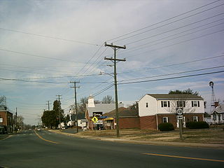
King George is a census-designated place (CDP) in and the county seat of King George County, Virginia, United States. It is sometimes referred to as King George Courthouse, because it is the location of the King George County Courthouse. The population as of the 2020 census was 4,970. The Journal Press was a local weekly newspaper published in King George and serving local areas until its final issue was published on Jan 11th, 2017.

State Route 218 is a primary state highway in the U.S. state of Virginia. The state highway runs 30.00 miles (48.28 km) from U.S. Route 1 and US 17 Business in Falmouth east to SR 205 in Tetotum. SR 218 connects suburban communities in Stafford County east of Fredericksburg with rural areas in northern and eastern King George County.

The Chuckanut Mountains, or Chuckanuts, are located on the northern Washington state coast of the Salish Sea, just south of Bellingham, Washington. Being a part of the Cascade Range, they are the only place where the Cascades come west down to meet the sea. The Chuckanuts are considered to be a part of the Puget Lowland Forest Ecoregion.
The Chuckanut Formation in northwestern Washington, its extension in southwestern British Columbia, and various related formations in central Washington are fluvial sedimentary formations of Eocene age, deposited from about 54 million years ago to around 34 million years ago. The nature of the deposits and included plant fossils indicate a low-lying coastal plain with a subtropical climate; the nature of the sediments indicates metamorphic sources in northeastern Washington.

King William County is a county located in the U.S. state of Virginia. As of the 2020 census, the population was 17,810. Its county seat is King William.

This is a list of the National Register of Historic Places listings in King George County, Virginia.

Ginkgo dissecta is an extinct ginkgo species in the family Ginkgoaceae described from a series of isolated fossil leaves. The species is known from Early Eocene sediments exposed in the province of British Columbia, Canada, and Washington, USA. It is one of two Ginkgo species found at the Washington and British Columbia sites.
Jordan David Mustoe is an English footballer who plays as a left back for Warrington Rylands.

Mustoe is an unincorporated community in Highland County, Virginia, United States. Mustoe is located 6.9 miles (11.1 km) south-southwest of Monterey, Virginia. The community is situated along U.S. Route 220 on the banks of the Jackson River. According to the National Weather Service, the only tornado on record in Highland County occurred near Mustoe in 1959.

Mustoe House is a historic home located near Hot Springs, Bath County, Virginia. The log structure was built in three sections in the early- to mid-19th century. They are a two-story front section, a 1+1⁄2-story log hyphen, and a separate 1+1⁄2-story log structure. It has a large exterior-end limestone chimney. Also on the property is a contributing small log spring house or meathouse.
Virginia's 99th House of Delegates district elects one of the 100 members of the Virginia House of Delegates, the lower house of the state's bicameral legislature. The district is made up of the counties of King George, Lancaster, Northumberland, Richmond, Westmoreland, and part of Caroline County. Other than King George, the combined area is called the Northern Neck of Virginia.


