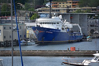
NOAAS Discoverer (R 102), originally USC&GS Discoverer (OSS 02), was an American Oceanographer-class oceanographic research vessel in service in the United States Coast and Geodetic Survey from 1966 to 1970 and in the National Oceanic and Atmospheric Administration (NOAA) from 1970 to 1996.
Discoverer was laid down on 10 September 1963 by Aerojet General Shipyards at Jacksonville, Florida. A very serious fire in the area of her meat preparation room and freezers brought her construction to a stop, but it resumed and she was launched on 29 October 1964. Soon after launching, she was moved to the Maryland Shipbuilding and Drydock Company at Baltimore, Maryland, where she received a single computer system, the first system of its kind, which revolutionizing environmental data collection and processing; via the computer, Discoverer's propulsion and other machinery was automated through a centralized engine room control (CERC) system, which measured and recorded the ship's course and speed, magnetic field intensity, gravity, surface current, and temperature. She had chemistry, wet and dry oceanographic, meteorological, gravimetric, and photographiclaboratories. She also had several precision oceanographic winches and an underwater observation chamber.
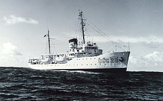
After successful sea trials– in which she outperformed her sister shipUSC&GS Oceanographer (OSS 01), making 17 knots (31km/h) ahead, 1 knot (1.9km/h) more than she was designed for, and 13 knots (24km/h) astern – she was delivered to the United States Government on 15 December 1966. At 303 feet (92m) in length, she and her sister Oceanographer — which entered service nine months before Discoverer — were the largest vessels constructed for research purposes to date.
Operational career
The U.S. Coast and Geodetic Survey classified the ship as an "ocean survey ship" (OSS) and commissioned her as USC&GS Discoverer (OSS 02),[1] the second Coast and Geodetic Survey ship of the name, on 29 April 1967 with Captain William F. Deane, USC&GS, in command. For 30 years, she operated in the Atlantic and Pacific Oceans and from the Arctic to the Antarcticice shelf. By conservative estimates, she steamed more than 1,000,000 nautical miles (1,900,000km) during her career, spending between 240 and 270 days of each year at sea.
Home-ported in Miami, Florida, Discoverer's first assignment was to represent the U.S. Government at the 1967 International and Universal Exposition, or Expo 67, in Montreal, Quebec, Canada; She was on display there from 2 July 1967 to 9 July 1967
Following Expo 67, Discoverer embarked on an intensive study of the Gregg Seamount in the North Atlantic Ocean. The research was the first of its kind to be conducted on a seamount. Discoverer's scientific expedition moored and recovered complex oceanographic instruments during the research. Despite encountering numerous malfunctions in the equipment, Discoverer's personnel persevered.
Later in 1967, after a minor overhaul at Jacksonville, Florida, Discoverer operated on research expeditions in the Gulf of Maine and over the Atlantic Ocean's Blake Plateau, investigating the status of manganese nodules on the ocean floor. In January 1968 she embarked on a three-month expedition of 20,000 nautical miles (37,000km) to gather information from the depths of the South Atlantic Ocean. She delivered personnel and equipment to the west coast of Africa, then headed back across the Atlantic to Cape Hatteras, North Carolina. Under the direction of Dr. Robert S. Dietz, she conducted operations in which data was used in the investigation of geological history and theories of continental drift.
NOAAS Discoverer (R 102)
When the Coast and Geodetic Survey and other United States Government agencies combined to form NOAA on 3 October 1970, Discoverer became part of the NOAA fleet as the research ship NOAAS Discoverer (R 102), the first NOAA ship to bear the name. Her home port later was shifted to Seattle, Washington. In 1985, she received a multi-beam bathymetricmappingsonar, the Inmarsatsatellite communications system, and a Global Position Indicator.
During her final field season in 1996, Discoverer provided the at-sea platform for two of the largest oceanographic experiments ever conducted—the first Aerosol Characterization Experiment and the final Pacific cruise for the World Ocean Circulation Experiment. These expeditions sought to determine the effects of atmosphericpollution on global climate, and to understand the physics of climate change on Earth. Results from these cruises were used to improve global climate, ocean circulation, and greenhouse gas models.
NOAA decommissionedDiscoverer at Seattle, Washington, on 16 August 1996. She remained inactive in reserve in the NOAA Pacific Fleet at Seattle until she was scrapped at Aliağa, Turkey in 2010.[2]
Shark attack
On March 23, 1994, Discoverer was in the Pacific Ocean 300 nautical miles (560km) east of Easter Island allowing several members of her crew to engage in recreational swimming when a shark attacked the swimmers. After biting Seaman Phil Buffington, inflicting wounds on his legs that would require over 50 stitches to close, the shark attacked Heather Boswell, a 19-year-old student aboard for a six-month stint working in Discoverer's galley. Another crew member filmed the shark pulling her under, shaking her and biting off her left leg at mid-thigh.[3] Three members of Discoverer's crew—Matthew Ofthus, Jon Knox, and Lisa Glover—came to her rescue in a boat, with two pulling her from the shark's jaws and into the boat while the third beat the shark with a stick. The shark then moved toward a third swimmer who was still partially in the water while climbing onto Discoverer via a rope ladder, but shots fired by crewmen aboard Discoverer apparently drove it away before it could attack.
Boswell and Buffington were brought aboard Discoverer, where the ship's nurse, Judeth Layne took charge of treating them. In Seattle, NOAA Corps commanders Lawrence Simoneaux, James Herkelrath, and Steve Stringfellow set up a command post to provide assistance to Layne aboard the ship and arranged logistical support for the evacuation of Buffington and Boswell and the arrival of emergency medical teams. A five-person Air Force Medical Team, led by Darr Lafon and Larry Martindale flew on a KC-135 from Howard AFB Panama to Easter Island to meet the ship. They stabilized Heather Boswell, who had lost almost half of her blood in the attack. After multiple transfusions, the team and ship's crew transported Boswell to Gorgas Army Hospital for initial closure of what remained of her left thigh. After stabilization overnight, with more transfusions for Boswell, both victims were transported back to Seattle in a C-21 Learjet air ambulance. In 1994, for their efforts in rescuing and saving the lives of the two injured swimmers, Layne, Ofthus, Knox, and Glover received the Department of Commerce Gold Medal and Simoneaux, Herkelrath, and Stringfellow received the Department of Commerce Silver Medal.[4][5]
NOAA Ship Rainier is a survey vessel in commission with the National Oceanic and Atmospheric Administration (NOAA). Her primary mission is to chart all aspects of the ocean and sea floor, primarily in Alaska and the Pacific Northwest. The ship is home-ported at the NOAA Marine Operations Center–Pacific in Newport, Oregon.
NOAAS Oceanographer, originally USC&GS Oceanographer, was an American Oceanographer-class oceanographic research vessel in service in the United States Coast and Geodetic Survey from 1966 to 1970 and in the National Oceanic and Atmospheric Administration (NOAA) from 1970 to 1996. She served as flagship of both the Coast and Geodetic Survey and NOAA fleets.
NOAA Ship Fairweather, originally operated by the United States Coast and Geodetic Survey as USC&GS Fairweather, is an oceanographic research ship operated by the National Oceanic and Atmospheric Administration (NOAA). Fairweather primarily conducts hydrographic surveys in Alaskan waters, but is considered a multi-mission-capable vessel and has conducted fisheries research cruises. She is the sister ship of the NOAAS Rainier and of the retired NOAAS Mount Mitchell.
NOAAS Mount Mitchell was an American survey vessel in commission in the National Oceanic and Atmospheric Administration from 1970 to 1995. Prior to her NOAA career, she was in commission in the United States Coast and Geodetic Survey as USC&GS Mount Mitchell from 1968 to 1970. In 2003, she returned to service as the private research ship R/V Mt. Mitchell.
USS Flamingo (AM-32) was a Lapwing-class minesweeper built for the United States Navy near the end of World War I. After service overseas clearing mines after the Armistice, the ship was laid up until 1922 when she was transferred to the United States Department of Commerce for use by the United States Coast and Geodetic Survey. Renamed USC&GS Guide, the ship operated as a survey vessel along the West Coast of the United States for 17 years, making significant contributions to navigation, hydrographic surveying, and oceanography. In June 1941, Guide was transferred back to the Navy, converted into a salvage ship, and renamed USS Viking (ARS-1). As Viking, she worked primarily from bases in California until 1953, when she was sold for scrapping.
Ronald George Mason was one of the oceanographers whose pioneering Cold War geomagnetic survey work lead to the discovery of magnetic striping on the seafloor. First discovering magnetic stripes on the bottom of the Pacific Ocean off the United States West Coast, he later also identified them around the Mid-Atlantic Ridge.
USS Oceanographer (AGS-3) was a survey ship of the United States Navy during World War II that produced charts chiefly of passages in the Solomon Islands area of the Pacific Ocean. Upon transfer to the Navy, she had initially briefly been named and classed as gunboat USS Natchez (PG-85). Before her World War II Navy service, she had been USC&GS Oceanographer (OSS-26), a survey ship with the United States Coast and Geodetic Survey from 1930.
USC&GS Oceanographer was the name of two ships of the United States Coast and Geodetic Survey, and may refer to:
The United States Coast and Geodetic Survey, known from 1807 to 1836 as the Survey of the Coast and from 1836 until 1878 as the United States Coast Survey, was the first scientific agency of the United States Government. It existed from 1807 to 1970, and throughout its history was responsible for mapping and charting the coast of the United States, and later the coasts of U.S. territories. In 1871, it gained the additional responsibility of surveying the interior of the United States and geodesy became a more important part of its work, leading to it being renamed the U.S. Coast and Geodetic Survey in 1878.
USS Mobjack (AVP-27/AGP-7) was a motor torpedo boat tender in commission in the United States Navy from 1943 to 1946. She saw service in the Pacific theater during the latter portion of World War II.
USC&GS Pioneer was a survey ship that served in the United States Coast and Geodetic Survey from 1922 to 1941. She was the first ship of the Coast and Geodetic Survey to bear the name.
NOAA Ship Surveyor was an oceanographic survey ship in commission in the National Oceanic and Atmospheric Administration (NOAA) from 1970 until 1995. Prior to her NOAA career, she was in commission in the United States Coast and Geodetic Survey from 1960 to 1970 as USC&GS Surveyor. She was the second and last Coast and Geodetic Survey ship named Surveyor and has been the only NOAA ship thus far to bear the name.
USC&GS Patton (ASV-80) was a survey ship that served in the United States Coast and Geodetic Survey from 1941 to 1967.
USC&GS Gilbert was a launch that served as a survey ship in the United States Coast and Geodetic Survey from 1930 to 1962.
The second USC&GS Explorer was a survey ship that served in the United States Coast and Geodetic Survey from 1940 to 1968. She operated in the Pacific Ocean from 1940 to 1960, seeing service there during World War II, and in the Atlantic Ocean from 1960 to 1968.
NOAAS Researcher, was an American oceanographic research vessel in commission in the National Oceanic and Atmospheric Administration (NOAA) from 1970 to 1996. She had been delivered to the United States Coast and Geodetic Survey in 1970 as USC&GS Researcher, but did not enter commission until after her transfer to NOAA later that year. In 1988, Researcher was renamed NOAAS Malcolm Baldrige.
Rear Admiral Robert Francis Anthony Studds was a career officer in the United States Coast and Geodetic Survey Corps, predecessor of the National Oceanic and Atmospheric Administration Commissioned Officer Corps. He served as the fourth Director of the United States Coast and Geodetic Survey.
Rear Admiral Harley Dean Nygren was an American military officer who served in the United States Coast and Geodetic Survey Corps, its successor, the Environmental Science Services Administration Corps, and the ESSA Corps's successor, the National Oceanic and Atmospheric Administration Commissioned Officer Corps. He served as the first Director of the NOAA Corps.
Rear Admiral Sigmund R. Petersen is a retired career officer who served in the United States Coast and Geodetic Survey Corps, its successor, the Environmental Science Services Administration Corps, and the ESSA Corps's successor, the National Oceanic and Atmospheric Administration Commissioned Officer Corps. He served as the fourth Director of the NOAA Corps.
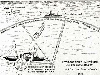
Radio acoustic ranging, occasionally written as "radio-acoustic ranging" and sometimes abbreviated RAR, was a method for determining a ship's precise location at sea by detonating an explosive charge underwater near the ship, detecting the arrival of the underwater sound waves at remote locations, and radioing the time of arrival of the sound waves at the remote stations to the ship, allowing the ship's crew to use true range multilateration to determine the ship's position. Developed by the United States Coast and Geodetic Survey in 1923 and 1924 for use in accurately fixing the position of survey ships during hydrographic survey operations, it was the first navigation technique in human history other than dead reckoning that did not require visual observation of a landmark, marker, light, or celestial body, and the first non-visual means to provide precise positions. First employed operationally in 1924, radio acoustic ranging remained in use until 1944, when new radio navigation techniques developed during World War II rendered it obsolete.
Prézelin, Bernard, and A. D. Baker III, eds. The Naval Institute Guide to Combat Fleets of the World 1990/1991: Their Ships, Aircraft, and Armament. Annapolis, Maryland: United States Naval Institute, 1990. ISBN0-87021-250-8.
This page is based on this Wikipedia article Text is available under the CC BY-SA 4.0 license; additional terms may apply. Images, videos and audio are available under their respective licenses.