NOAAS Fairweather

Last updated
NOOA Ship Fairweather.jpg
NOAA Ship Fairweather (S 220)
History
Flag of the United States.svg Flag of the United States Coast and Geodetic Survey.svg United States
NameUSC&GS Fairweather (MSS 20)
Namesake Mount Fairweather in Alaska
Builder Aerojet-General Shipyards, Jacksonville, Florida
Laid down12 August 1963
Launched15 March 1967
AcquiredJanuary 1968
Commissioned2 October 1968
FateTransferred to National Oceanic and Atmospheric Administration 3 October 1970
Flag of the United States.svg NOAA Flag.svg United States
NameNOAAS Fairweather (S 220)
NamesakePrevious name retained
AcquiredTransferred from U.S. Coast and Geodetic Survey 3 October 1970
Decommissioned1989
RecommissionedAugust 2004
Homeport Ketchikan, Alaska
Identification
StatusActive
General characteristics
Class and type Fairweather-class oceanographic research ship
TypeS1-MT-63a
Tonnage1,591 tons
Displacement1,800 tons
Length231 ft (70.4 m)
Beam42 ft (12.8 m)
Draft15.5 ft (4.7 m)
Ice classA1 ice strengthened
Propulsion
  • 2 Electro-Motive Diesel engines,
  • twin screw, controllable pitch propellers, 2400 shp
  • Bow Thruster (variable pitch)
  • Bridge Wing Controls (Engines, and Thruster) Port and Stbd
Speed12.5 knots
Range6,000 nautical miles
Endurance22 days
Boats & landing
craft carried
Four 28ft All-American Marine survey launches, One 23ft Zodiac FRB, One 23ft AMBAR Jet Boat
Complement
  • Commissioned Officers: 15
  • Licensed Engineers: 4
  • Crew: 35
  • Hydrographic Survey Technician s: 6 (Max)

NOAA Ship Fairweather (S 220), originally operated by the United States Coast and Geodetic Survey as USC&GS Fairweather (MSS 20), is an oceanographic research ship operated by the National Oceanic and Atmospheric Administration (NOAA). Fairweather primarily conducts hydrographic surveys in Alaskan waters, but is considered a multi-mission-capable vessel and has conducted fisheries research cruises. She is the sister ship of the NOAAS Rainier (S 221) and of the retired NOAAS Mount Mitchell (S 222).

Contents

Overview

NOAAS Fairweather (S 220) in Alaskan waters with Mount Fairweather in the background. NOAAS Fairweather (S 220) and Mount Fairweather.jpg
NOAAS Fairweather (S 220) in Alaskan waters with Mount Fairweather in the background.

Fairweather is named for Mount Fairweather in Alaska. She was constructed for the U.S. Coast and Geodetic Survey as a "medium survey ship" (MSS) by Aerojet-General Shipyards at Jacksonville, Florida. She was laid down on 12 August 1963 [1] and launched on 15 March 1967. The Coast and Geodetic Survey commissioned her as USC&GS Fairweather (MSS 20) in a joint ceremony with her sister ship USC&GS Rainier (MSS 21) at the Pacific Marine Center in Seattle, Washington, on 2 October 1968. [2] [3] When NOAA was established on 3 October 1970 and took over the Coast and Geodetic Survey's assets, she became part of the NOAA fleet as NOAAS Fairweather (S 220). Deactivated in 1989, the ship remained inactive at NOAA's Pacific Marine Center in Seattle for thirteen years. In 2002, she began a refit at the Cascade General Shipyard in Portland, Oregon, and she was recommissioned in 2004 to aid with the backlog of critical surveys in Alaskan waters. In 2008 her home port pier was condemned by NOAA. In 2023 the pier was reopened. Her home port is Ketchikan, Alaska.

[4]

Crew

Fairweather, like all NOAA ships, is a ship and is operated by commissioned officers of the NOAA Corps and civilian wage mariners. Fairweather was originally complemented for a crew of 69 people, with additional berthing capability for visitors and scientists. Now the ship is complimented at 45 people. In 2022 the Chief Engineer (CME) became the youngest person to make CME in NOAA history. The ship generally spends over 150 days per year at sea.

Equipment and mission

Fairweather has two Kongsberg Gruppen multibeam echosounders, models EM712 and EM2040. Her four survey launches have Kongsberg EM2040 multibeam echosounders. In addition, Fairweather can tow an L3/Klein System 5000 sidescan sonar, and her launches can be equipped with additional hull-mounted L3/Klein System 5000 sidescan sonars. These sidescan sonars are used for near-shore Arctic survey operations. Additionally, Fairweather's personnel routinely establish horizontal and vertical control instruments, such as Global Positioning System (GPS) base stations and tide-level measuring devices, in the remote areas in which the ship works. Using this technology, the crew of Fairweather can map the ocean floor fully. These data are primarily used to update NOAA's nautical charts, but are increasingly used in other areas such as tsunami displacement modeling, flood mapping, and the mapping of fish habitats.

Service history

On 30 April and 1 May 2017, the NOAA research ship NOAAS Oscar Dyson (R 224) surveyed an area in the Bering Sea off Dalnoi Point on the northwestern tip of St. George Island in the Pribilof Islands in a search for the wreck of the 92-foot (28.0 m) crab-fishing boat Destination, which had capsized and sunk in the area with the loss of her entire crew of six men on 11 February 2017. She did not find the wreck, but her survey narrowed the search area for Fairweather, which discovered the wreck in about 250 feet (76 m) of water during a survey on 8 and 9 July 2017. [5] [6]

Related Research Articles

<span class="mw-page-title-main">Hydrographic survey</span> Science of measurement and description of features which affect maritime activities

Hydrographic survey is the science of measurement and description of features which affect maritime navigation, marine construction, dredging, offshore oil exploration and drilling and related activities. Strong emphasis is placed on soundings, shorelines, tides, currents, seabed and submerged obstructions that relate to the previously mentioned activities. The term hydrography is used synonymously to describe maritime cartography, which in the final stages of the hydrographic process uses the raw data collected through hydrographic survey into information usable by the end user.

NOAAS <i>Rude</i>

NOAAS Rude was an American Rude-class hydrographic survey ship that was in commission in the National Oceanic and Atmospheric Administration (NOAA) from 1970 to 2008. Prior to its NOAA career, it was in commission in the United States Coast and Geodetic Survey from 1967 to 1970 as USC&GS Rude. It was named for Gilbert T. Rude, former Chief of the Division of Coastal Surveys of the Coast and Geodetic Survey.

NOAAS <i>Rainier</i> Medium survey ship based in Newport, Oregon (USA)

NOAA Ship Rainier is a survey vessel in commission with the National Oceanic and Atmospheric Administration (NOAA). Her primary mission is to chart all aspects of the ocean and sea floor, primarily in Alaska and the Pacific Northwest. The ship is home-ported at the NOAA Marine Operations Center - Pacific in Newport, Oregon.

<span class="mw-page-title-main">Multibeam echosounder</span> Type of sonar used to map the seabed

A multibeam echosounder (MBES) is a type of sonar that is used to map the seabed. It emits acoustic waves in a fan shape beneath its transceiver. The time it takes for the sound waves to reflect off the seabed and return to the receiver is used to calculate the water depth. Unlike other sonars and echo sounders, MBES uses beamforming to extract directional information from the returning soundwaves, producing a swathe of depth soundings from a single ping.

NOAAS <i>Thomas Jefferson</i>

NOAAS Thomas Jefferson is a National Oceanic and Atmospheric Administration (NOAA) hydrographic survey vessel in service since 2003. The ship was built for the United States Navy as USNS Littlehales (T-AGS-52) serving as one of two new coastal hydrographic survey vessels from 1992 until transfer to NOAA in 2003 when it was named after Founding Father and third U.S. president, Thomas Jefferson.

NOAAS <i>Mount Mitchell</i>

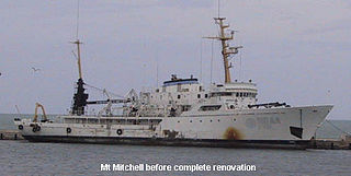
NOAAS Mount Mitchell was an American survey vessel in commission in the National Oceanic and Atmospheric Administration from 1970 to 1995. Prior to her NOAA career, she was in commission in the United States Coast and Geodetic Survey as USC&GS Mount Mitchell from 1968 to 1970. In 2003, she returned to service as the private research ship R/V Mt. Mitchell.

<span class="mw-page-title-main">United States Coast and Geodetic Survey</span> Former U.S. government scientific agency

The United States Coast and Geodetic Survey, known from 1807 to 1836 as the Survey of the Coast and from 1836 until 1878 as the United States Coast Survey, was the first scientific agency of the United States Government. It existed from 1807 to 1970, and throughout its history was responsible for mapping and charting the coast of the United States, and later the coasts of U.S. territories. In 1871, it gained the additional responsibility of surveying the interior of the United States and geodesy became a more important part of its work, leading to it being renamed the U.S. Coast and Geodetic Survey in 1878.

USC&GS <i>Thomas R. Gedney</i>

USC&GS Thomas R. Gedney, originally USCS Thomas R. Gedney, was a survey ship in service in the United States Coast Survey from 1875 to 1878 and in the United States Coast and Geodetic Survey from 1878 to 1915.

USS <i>Surveyor</i>

USS Surveyor was an armed steamer that served in the United States Navy from 1917 to 1919. Prior to her U.S. Navy service, she operated as the survey ship USC&GS Surveyor for the United States Coast and Geodetic Survey in 1917, and she returned to that role after her U.S. Navy decommissioning, remaining in Coast and Geodetic Survey service until 1956.

NOAAS <i>Surveyor</i>

NOAA Ship Surveyor was an oceanographic survey ship in commission in the National Oceanic and Atmospheric Administration (NOAA) from 1970 until 1995. Prior to her NOAA career, she was in commission in the United States Coast and Geodetic Survey from 1960 to 1970 as USC&GS Surveyor. She was the second and last Coast and Geodetic Survey ship named Surveyor and has been the only NOAA ship thus far to bear the name.

USCS <i>Robert J. Walker</i>

USCS Robert J. Walker was a survey ship that served in the United States Coast Survey, a predecessor of the United States Coast and Geodetic Survey, from 1848 until sinking in 1860 after a collision at sea. Her loss resulted in the death of 20 men, the greatest loss of life in single incident ever to befall the National Oceanic and Atmospheric Administration or any of its ancestor agencies. It was added to the National Register of Historic Places on March 19, 2014.

USC&GS <i>Discoverer</i> (1918) The first of this name was a survey ship in the United States Coast and Geodetic Survey

The first USC&GS Discoverer was a survey ship that served in the United States Coast and Geodetic Survey from 1922 to 1941.

NOAAS <i>Heck</i>

NOAAS Heck was a Rude-class hydrographic survey ship in the National Oceanic and Atmospheric Administration (NOAA) from 1970 to 1995. Prior to her NOAA service, she was in commission from 1967 to 1970 in the United States Coast and Geodetic Survey as USC&GS Heck.

USC&GS <i>McArthur</i> (1874)

The first USC&GS McArthur, originally USCS McArthur, was a steamer that served as a survey ship in the United States Coast Survey from 1876 to 1878 and in the United States Coast and Geodetic Survey from 1878 to 1915.

NOAAS <i>Davidson</i>

NOAAS Davidson was a survey ship in commission in the National Oceanic and Atmospheric Administration (NOAA) from 1970 to 1989. Prior to her NOAA service, she was in commission in the United States Coast and Geodetic Survey from 1967 to 1970 as USC&GS Davidson, the second Coast and Geodetic Survey ship of the name. She was the only sister ship of NOAAS McArthur (S 330).

NOAAS <i>Whiting</i>

NOAAS Whiting, was an American survey ship that was in commission in the National Oceanic and Atmospheric Administration (NOAA) from 1970 to 2003. Previously, she had been in commission in the United States Coast and Geodetic Survey from 1963 to 1970 as USC&GS Whiting.

NOAAS <i>Peirce</i>

NOAAS Peirce, was an American survey ship that was in commission in the National Oceanic and Atmospheric Administration (NOAA) from 1970 to 1992. Previously, she had been in commission in the United States Coast and Geodetic Survey from 1963 to 1970 as USC&GS Peirce.

NOAAS <i>Oscar Dyson</i>

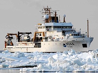
NOAAS Oscar Dyson is an American fisheries and oceanographic research vessel in commission in the National Oceanic and Atmospheric Administration (NOAA) fleet since 2005.

The RV Denar 2 is a Turkish research and survey vessel owned by TOMA Maritime S.A. Istanbul, Turkey and operated 2E Maritime in Istanbul, Turkey.

<span class="mw-page-title-main">Nicholas H. Heck</span> American USCGSC officer (1882–1953)

Captain Nicholas Hunter Heck was a career officer of the United States Coast and Geodetic Survey Corps. A leading geophysicist of his time, Heck made important contributions in the study of seismology and oceanography. He also revolutionized hydrographic surveying by developing the wire-drag surveying technique and introduced radio acoustic ranging into Coast and Geodetic Survey hydrography.

References

  1. Invitation to keel laying of Coast and Geodetic Survey Ship FAIRWEATHER on August 12, 1963
  2. Invitation to joint commissioning ceremony of ESSA Ships FAIRWEATHER and RAINIER on October 2, 1968
  3. APPENDIX E: CLASS II HYDROGRAPHIC SURVEY SHIPS, p. 8.
  4. Sullivan, Dan. "SULLIVAN, KETCHIKAN CELEBRATE COMPLETION OF NEW PIER, RETURN OF NOAA FAIRWEATHER". sullivan.senate.gov. Retrieved 2023-10-02.
  5. Bernton, Hal (11 February 2019). "No return: The final voyage of the crab boat Destination". Seattle Times. Retrieved 25 January 2021.
  6. Andrews, Laurel (21 July 2017). "Wreck of fishing boat that sank in Bering Sea found by NOAA searchers". Anchorage Daily News. Retrieved 25 January 2021.

Commons-logo.svg Media related to NOAA S 220 Fairweather (ship, 1968) at Wikimedia Commons