NOAAS Peirce

Last updated
USC&GS Pierce (CSS 28).jpg
USC&GS Peirce (CSS 28)
History
Flag of the United States.svg Flag of the United States Coast and Geodetic Survey.svg United States
NameUSC&GS Peirce (CSS 28)
Namesake Charles Sanders Peirce (1839-1914), U.S. Coast Survey and U.S. Coast and Geodetic Survey employee (1859-1891), an intellectual, physical scientist, and philosopher
Builder Marietta Manufacturing Company, Point Pleasant, West Virginia
LaunchedOctober 1962
AcquiredMay 1963 (delivery)
Commissioned6 May 1963
FateTransferred to National Oceanic and Atmospheric Administration 3 October 1970
Flag of the United States.svg NOAA Flag.svg United States
NameNOAAS Peirce (S 328)
NamesakePrevious name retained
AcquiredTransferred from U.S. Coast and Geodetic Survey 3 October 1970
Decommissioned1 May 1992
Homeport Norfolk, Virginia
Identification
  • Radio call sign WTEQ
  • ICS Whiskey.svg ICS Tango.svg ICS Echo.svg ICS Quebec.svg
FateDonated to Intrepid Sea, Air & Space Museum 1992
Flag of the United States.svgUnited States
NameMV Elizabeth M. Fisher
NamesakeElizabeth M. Fisher, co-founder of the Fisher House Foundation and wife of Intrepid Sea, Air & Space Museum founder Zachary Fisher
OwnerIntrepid Sea, Air & Space Museum
OperatorIntrepid Sea, Air & Space Museum
Port of registryUnited States
AcquiredDonated by National Oceanic and Atmospheric Administration 1992
Homeport New York, New York
FateSold to private owner 1999
NotesFloating classroom and archaeological research ship
Flag of the United States.svgUnited States
NameMV Avedonia
OwnerPrivate ownership
Port of registryUnited States
AcquiredSold by Intrepid Sea, Air & Space Museum 1999
Homeport Dover, Delaware
Identification IMO number:  6407561
StatusActive
NotesPrivate yacht
General characteristics (as survey ship)
Class and type Peirce-class survey ship
TypeS1-MT-59a
Tonnage
Displacement907 tons
Length49.7 m (163 ft)
Beam10.1 m (33 ft)
Draft
  • 3.4 m (11 ft) (maximum)
  • 3.7 m (12 ft) (with IDSSS dome)
PropulsionTwo geared 800-bhp (597-kW) General Motors diesel engines, two shafts, 4,300 U.S. gallons (16,277 liters fuel
Speed12.0 knots
Range5,700 nm
Endurance20 days
Crew33 (8 officers, 25 other crew, 2 scientists) plus up to 6 temporarily embarked personnel

NOAAS Peirce (S 328), was an American survey ship that was in commission in the National Oceanic and Atmospheric Administration (NOAA) from 1970 to 1992. Previously, she had been in commission in the United States Coast and Geodetic Survey from 1963 to 1970 as USC&GS Peirce (CSS 28).

Contents

After her NOAA decommissioning, she was donated to the Intrepid Sea, Air & Space Museum for use as the floating classroom and archaeological research ship MV Elizabeth M. Foster. She was sold for private use in 1999 and in 2001 became the yacht MV Avedonia.

Construction and commissioning

USC&GS Peirce (CSS 28) is launched by the Marietta Manufacturing Company at Point Pleasant, West Virginia, in October 1962. USC&GS Pierce (CSS 28) launching.jpg
USC&GS Peirce (CSS 28) is launched by the Marietta Manufacturing Company at Point Pleasant, West Virginia, in October 1962.

Peirce was built a cost of $2,300,000 (USD) as a "coastal survey ship" (CSS) for the U.S. Coast and Geodetic Survey by the Marietta Manufacturing Company at Point Pleasant, West Virginia. [1] She was launched in October 1962 and delivered in May 1963. [2] [3] The Coast and Geodetic Survey commissioned her on 6 May 1963 [4] at the Alabama State Docks in Mobile, Alabama, [4] as USC&GS Peirce (CSS 28), [2] [3] [5] the first and only Coast and Geodetic Survey ship of the name. When the Coast and Geodetic Survey and other United States Government agencies merged to form NOAA on 3 October 1970, Peirce became a part of the NOAA fleet as NOAAS Peirce (S 328), thus far the only NOAA ship to bear the name.

Capabilities

Peirce had a two-drum oceanographic winch with a maximum pull of 1,500 pounds (680 kg). The upper drum had 10,000 feet (3,000 meters) of 0.3-inch (7.62-mm) electrical cable, while the lower drum had 15,000 feet (4,600 meters) of 5/16-inch (7.9-mm) cable. She had a 27-foot (8.2-meter) telescoping boom with a lifting capacity of 2,500 pounds (1,100 kg) and a 27-foot (8.2-meter) articulating boom with a lifting capacity of 2,768 pounds (1,256 kg), as well as a movable A-frame. [3]

For acoustic hydrography and bathymetry, the ship had a deep-water echosounder, a shallow-water echosounder-lOOKhz, and a hydrographic survey sounder. To process data, she had the National Ocean Service 's Hydrochart system, which employed a PDP/8E computer to acquire and process hydrographic data in real time, generate a real-time position-corrected plot of sounding data, provide steering commands to the helmsman, and generate a punched paper tape for shore-based processing of sounding dara. [3]

Peirce had an ice-strengthened steel hull. [3]

Peirce carried two 29-foot (8.8-meter) aluminum-hulled diesel-powered Jensen survey launches, each equipped with the same Hydrochart system as aboard Peirce. For utility and rescue purposes, she also carried two open boats with gasoline-powered outboard motors, a 16-foot (4.9-meter) Boston Whaler fiberglass-hulled boat and 17-foot (5.2-meter) Monark aluminum-hulled boat. [3]

Operational career

From her home port at Norfolk, Virginia, Peirce conducted hydrographic and bathymetric surveys involving nautical charting and ocean mapping, primarily along the United States East Coast and United States Gulf Coast and off territories of the United States in the Caribbean. [1] [3]

NOAA decommissioned Peirce on 1 May 1992. [5]

Floating classroom and yacht

In 1992, Peirce was donated to the Intrepid Sea, Air & Space Museum in New York City. The museum acquired her for use as a floating classroom and archaeological research ship and renamed her MV Elizabeth M. Fisher in 1993. In 1999 the museum sold her for private use, and in 2000 she returned to the name MV Peirce. By 2001 she was operating as the private yacht MV Avedonia. [5] [6] [7] [8]

See also

Related Research Articles

<span class="mw-page-title-main">Hydrographic survey</span> Science of measurement and description of features which affect maritime activities

Hydrographic survey is the science of measurement and description of features which affect maritime navigation, marine construction, dredging, offshore wind farms, offshore oil exploration and drilling and related activities. Surveys may also be conducted to determine the route of subsea cables such as telecommunications cables, cables associated with wind farms, and HVDC power cables. Strong emphasis is placed on soundings, shorelines, tides, currents, seabed and submerged obstructions that relate to the previously mentioned activities. The term hydrography is used synonymously to describe maritime cartography, which in the final stages of the hydrographic process uses the raw data collected through hydrographic survey into information usable by the end user.

<span class="mw-page-title-main">Office of Marine and Aviation Operations</span> US platforms operated by NOAA

The Office of Marine and Aviation Operations (OMAO) is a division of the National Oceanic and Atmospheric Administration (NOAA) which operates a wide variety of specialized ships and aircraft to carry out the environmental and scientific missions of NOAA.

NOAAS <i>Rude</i>

NOAAS Rude was an American Rude-class hydrographic survey ship that was in commission in the National Oceanic and Atmospheric Administration (NOAA) from 1970 to 2008. Prior to its NOAA career, it was in commission in the United States Coast and Geodetic Survey from 1967 to 1970 as USC&GS Rude. It was named for Gilbert T. Rude, former Chief of the Division of Coastal Surveys of the Coast and Geodetic Survey.

NOAAS <i>Fairweather</i> US Research and hydrographic survey ship based in Alaska (1967)

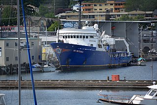
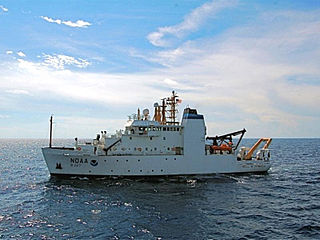
NOAA Ship Fairweather, originally operated by the United States Coast and Geodetic Survey as USC&GS Fairweather, is an oceanographic research ship operated by the National Oceanic and Atmospheric Administration (NOAA). Fairweather primarily conducts hydrographic surveys in Alaskan waters, but is considered a multi-mission-capable vessel and has conducted fisheries research cruises. She is the sister ship of the NOAAS Rainier and of the retired NOAAS Mount Mitchell.

NOAAS <i>Mount Mitchell</i>

NOAAS Mount Mitchell was an American survey vessel in commission in the National Oceanic and Atmospheric Administration from 1970 to 1995. Prior to her NOAA career, she was in commission in the United States Coast and Geodetic Survey as USC&GS Mount Mitchell from 1968 to 1970. In 2003, she returned to service as the private research ship R/V Mt. Mitchell.

<span class="mw-page-title-main">United States Coast and Geodetic Survey</span> Former U.S. government scientific agency

The United States Coast and Geodetic Survey, known from 1807 to 1836 as the Survey of the Coast and from 1836 until 1878 as the United States Coast Survey, was the first scientific agency of the United States Government. It existed from 1807 to 1970, and throughout its history was responsible for mapping and charting the coast of the United States, and later the coasts of U.S. territories. In 1871, it gained the additional responsibility of surveying the interior of the United States and geodesy became a more important part of its work, leading to it being renamed the U.S. Coast and Geodetic Survey in 1878.

USS <i>Lydonia</i> Patrol vessel of the United States Navy

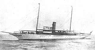
USS Lydonia (SP-700) was United States Navy patrol vessel in commission from 1917 to 1919 that saw service during World War I. Prior to her U.S. Navy service, she had been William A. Lydon's private yacht, Lydonia II, from 1912 to 1917. She spent most of the war based at Gibraltar, escorting and protecting Allied ships in the Mediterranean and along the Atlantic Ocean coast of Europe. After her U.S. Navy service ended, she served from 1919 to 1947 in the United States Coast and Geodetic Survey as the coastal survey ship USCGS Lydonia (CS-302).

USS <i>Mobjack</i> Tender of the United States Navy

USS Mobjack (AVP-27/AGP-7) was a motor torpedo boat tender in commission in the United States Navy from 1943 to 1946. She saw service in the Pacific theater during the latter portion of World War II.

NOAAS <i>Surveyor</i> U.S. oceanographic survey ship

NOAA Ship Surveyor was an oceanographic survey ship in commission in the National Oceanic and Atmospheric Administration (NOAA) from 1970 until 1995. Prior to her NOAA career, she was in commission in the United States Coast and Geodetic Survey from 1960 to 1970 as USC&GS Surveyor. She was the second and last Coast and Geodetic Survey ship named Surveyor and has been the only NOAA ship thus far to bear the name.

NOAAS <i>Heck</i>

NOAAS Heck was a Rude-class hydrographic survey ship in the National Oceanic and Atmospheric Administration (NOAA) from 1970 to 1995. Prior to her NOAA service, she was in commission from 1967 to 1970 in the United States Coast and Geodetic Survey as USC&GS Heck.

NOAAS <i>Davidson</i>

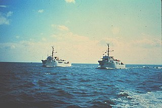
NOAAS Davidson was a survey ship in commission in the National Oceanic and Atmospheric Administration (NOAA) from 1970 to 1989. Prior to her NOAA service, she was in commission in the United States Coast and Geodetic Survey from 1967 to 1970 as USC&GS Davidson, the second Coast and Geodetic Survey ship of the name. She was the only sister ship of NOAAS McArthur (S 330).

NOAAS <i>Bell M. Shimada</i>

NOAAS Bell M. Shimada is an American fisheries research ship in commission with the National Oceanic and Atmospheric Administration (NOAA) since 2010. She operates along the United States West Coast.

NOAAS <i>Reuben Lasker</i> American fisheries research vessel

NOAAS Reuben Lasker is a National Oceanic and Atmospheric Administration (NOAA) fishery research vessel. The ship's namesake, Reuben Lasker, was a fisheries biologist who served with the Southwest Fisheries Center, National Marine Fisheries Service, and taught at the Scripps Institution of Oceanography.

USC&GS <i>Explorer</i> (OSS 28)

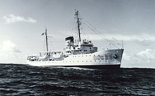
The second USC&GS Explorer was a survey ship that served in the United States Coast and Geodetic Survey from 1940 to 1968. She operated in the Pacific Ocean from 1940 to 1960, seeing service there during World War II, and in the Atlantic Ocean from 1960 to 1968.

NOAAS <i>Whiting</i>

NOAAS Whiting, was an American survey ship that was in commission in the National Oceanic and Atmospheric Administration (NOAA) from 1970 to 2003. Previously, she had been in commission in the United States Coast and Geodetic Survey from 1963 to 1970 as USC&GS Whiting.

NOAAS <i>Oregon II</i> American fisheries research vessel

NOAAS Oregon II is an American fisheries research vessel in commission in the National Oceanic and Atmospheric Administration (NOAA) fleet since 1977. Prior to her NOAA career, she was delivered to the United States Fish and Wildlife Service's Bureau of Commercial Fisheries in 1967 as US FWS Oregon II, but not commissioned. She was transferred to NOAA in 1970, but was not placed in commission until 1977.

NOAAS <i>Townsend Cromwell</i> American fisheries research vessel

NOAAS Townsend Cromwell was an American fisheries research vessel that was in commission in the National Oceanic and Atmospheric Administration (NOAA) fleet from 1975 to 2002. Prior to her NOAA career, she was in the United States Fish and Wildlife Service's Bureau of Commercial Fisheries fleet from 1963 to 1975 as US FWS Townsend Cromwell.

NOAAS <i>David Starr Jordan</i> American fisheries research vessel

NOAAS David Starr Jordan (R444)) was an American fisheries research vessel in commission in the National Oceanic and Atmospheric Administration (NOAA) from 1970 to 2010. She previously was in the United States Fish and Wildlife Service's Bureau of Commercial Fisheries fleet from 1966 to 1970 as US FWS David Starr Jordan.

NOAAS <i>Oscar Dyson</i>

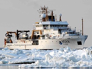
NOAAS Oscar Dyson is an American fisheries and oceanographic research vessel in commission in the National Oceanic and Atmospheric Administration (NOAA) fleet since 2005.

USS <i>PCS-1405</i> Minesweeper of the United States Navy

USS PCS-1405 was a United States Navy minesweeper in commission from 1944 to 1946. She saw service in the latter stages of World War II.

References

  1. 1 2 "CHARLES S. PEIRCE". Archived from the original on 29 October 2004.
  2. 1 2 "We couldn't find that Web page (Error 404) - Government of Canada Web Usability theme / Nous ne pouvons trouver cette page Web (Erreur 404) - Thème de la facilité d'emploi Web du gouvernement du Canada" (PDF). www.dfo-mpo.gc.ca. Retrieved 2020-09-21.
  3. 1 2 3 4 5 6 7 Ships of the NOAA fleet. MBLWHOI Library. Rockville, Md. : U.S. Dept. of Commerce, National Oceanic and Atmospheric Administration, Office of NOAA Corps Operations. 1989.{{cite book}}: CS1 maint: others (link)
  4. 1 2 "Invitation to commissioning ceremony of Coast and Geodetic Survey Ship PEIRCE on May 6, 1963". Archived from the original on 4 December 2013.
  5. 1 2 3 "PORT". conceptualstructures.org. Retrieved 2020-09-21.
  6. "Newsletter: Vol 1, #1". peirce.sitehost.iu.edu. Retrieved 2020-09-21.
  7. "AVEDONIA - 6407561 - YACHT". maritime-connector.com. Retrieved 2020-09-21.
  8. "Avedonia". Archived from the original on 2 June 2014.