
Himachal Pradesh is a state in the northern part of India. Situated in the Western Himalayas, it is one of the thirteen mountain states and is characterised by an extreme landscape featuring several peaks and extensive river systems. Himachal Pradesh is the northernmost state of India and shares borders with the union territories of Jammu and Kashmir and Ladakh to the north, and the states of Punjab to the west, Haryana to the southwest, Uttarakhand to the southeast and a very narrow border with Uttar Pradesh to the south. The state also shares an international border to the east with the Tibet Autonomous Region in China. Himachal Pradesh is also known as Dev Bhoomi or Dev Bhumi, meaning 'Land of Gods' and Veer Bhoomi which means 'Land of the Brave'.

Solan is a city in the Indian state of Himachal Pradesh and the district headquarters of Solan district. It is located 45.5 kilometres (28 mi) south of the state capital, Shimla. Solan has an average elevation of 1,550 metres (5,090 ft). The city is situated between Chandigarh and Shimla on the Kalka-Shimla National Highway-5. The narrow-gauge Kalka-Shimla railway passes through Solan. Located on the Punjab-Himachal Border, Solan is nestled in the Shivalik hills of the Himalayas.
Bilaspur is a town and a municipal council in Bilaspur district in the Indian state of Himachal Pradesh.

Una is a City and a Municipal Council in Una district in the Indian state of Himachal Pradesh. It serves as the headquarters of Una district. There are 11 wards under Municipal Council. Una City is home to the Kila, which is a historical fort and an ancestral home of the descendants of the first guru of the Sikhs, Guru Nanak.

Kangra is a city and a municipal council in Kangra district in the Indian state of Himachal Pradesh. It is also known as Nagarkot.

Solan district is one of the twelve districts of the Himachal Pradesh state in northern India. The city of Solan is the administrative headquarters of the district. The district occupies an area of 1936 km2.

Bilaspur State or Kahlur State, sometimes Kahloor Riyasat, was a kingdom (697–1849) and later princely state (1849–1948) in the Punjab Province ruled by a separate branch of Chandravanshi Chandel rajput dynasty. Raja Bir Chand 697–730 was the founder of the state but it was named Kahlur only after the Construction of Kahlur Fort by Raja Kahal Chand around 890–930CE and Raja Anand Chand the 44th Raja was the last ruler.

Basohli is a town near Kathua in Kathua district in the union territory of Jammu and Kashmir, India. It is situated on the right bank of River Ravi at an altitude of 1876 ft. It was founded by Raja Bhupat Pal sometime in 1635. It was known for the palaces which are now in ruins and miniatures paintings. The Battle of Basoli was fought in this region.
Chenani is a town and tehsil in the Udhampur district, in the Indian union territory of Jammu and Kashmir. It is governed by a notified area council. Before 1947, it was an internal jagir ruled by a Chandel (Rajput) ruler in the princely state of Jammu and Kashmir. This Town has further gained importance after getting the Asia's longest tunnel from chenani to nasari.
Kotkhai is a town and a Nagar Panchayat in Shimla district in the Indian state of Himachal Pradesh.The name Kotkhai is derived from Hindi and Urdu language where the name "Kot" means Kings Palace and "Khai" means depth, therefore "Kotkhai" means "Kings palace situated in depth". It is a tehsil with around 40 villages under its administration. The whole tehsil is known for quality apple production. Kotkhai is also known for its fairs and traditional values, people of Kotkhai are really devotional towards Devtas where each villages believes in different forms of Devtas.

Theog is a town and a municipal committee as well as a tehsil in Shimla district in the Indian state of Himachal Pradesh. It is 30 km from state capital Shimla & 37 km from ISBT Shimla. First settlements were in 1902.

Puadh is a historic region in north India that comprises parts of present-day Punjab, Haryana, Uttar Pradesh, Himachal Pradesh and the U.T. of Chandigarh, India. It has the Sutlej river in its north and covers the regions immediately south of the Ghaggar river. The people of the area are known as Puadhi and speak the Puadhi dialect of Punjabi. The capital cities of Puadh region are Rupnagar, Fatehgarh Sahib, Mohali, Patiala, Chandigarh, Nalagarh,Panchkula, Baddi ,Ambala, Yamunanagar
Punjab is home to 2.3% of India's population; with a density of 551 persons per km2. According to the provisional results of the 2011 national census, Punjab has a population of 27,743,338, making it the 16th most populated state in India. Of which male and female are 14,639,465 and 13,103,873 respectively. 32% of Punjab's population consists of Dalits. In the state, the rate of population growth is 13.9% (2011), lower than national average. Out of total population, 37.5% people live in urban regions. The total figure of population living in urban areas is 10,399,146 of which 5,545,989 are males and while remaining 4,853,157 are females. The urban population in the last 10 years has increased by 37.5%. According to the 2011 Census of India, Punjab, India has a population of around 27.7 million.

Chamba State was one of the oldest princely states in present-day Republic of India, having been founded during the late 6th century. It was part of the States of the Punjab Hills of the Punjab Province in India from 1859 to 1947. Its last ruler signed the instrument of accession to the Indian Union of 15 April 1948.

Kumarsain, also known as Kumharsain, is a town in Shimla District in the Indian state of Himachal Pradesh. Formerly under the British Raj, it was the capital of princely state of Kumharsain, which was one of the several states of the Punjab States Agency. It is about 80 km from Shimla and famous for apple and cherry orchards.
Chandel or Chandela is a Rajput clan from India. Families belonging to this clan ruled several kingdoms in north India and held various feudal estates. The most notable of these were the Chandelas of Jejakabhukti, who ruled the Bundelkhand region.
Barsar is a historical town which has its roots linked to the Sidh Shri Baba Balak Nath Ji, a Hindu deity located in the Hamirpur district of Himachal Pradesh. Located primarily on the Foothills Of Western Shivalik Range Of The Outer Himalayas on National Highway 503 A, it is a major Business and Educational Hub in the district. Barsar Hilltop overlooks Lake Govind Sagar due South West and The Dhauladhar Himalayas due north. Founded by Rajput Prince as a Princely state, used their clan name Barsar as the name of state. After separation of India it was merged in India. Now it is also a part of Himachal Pradesh. Barsar is one of the most developing and enhancing educational locations in the state and it also serves as one of five tehsil headquarters in the Hamirpur district. Barsar Hilltop separates Hamirpur to Una District at an elevation of 1015 M above sea level.
His Highness Raja Sir Anand Chand was the 44th Raja of Bilaspur. He was a Member of Parliament, representing Bihar in the Rajya Sabha, the upper house of India's Parliament as a member of the Indian National Congress.
Jubbal State was a non-salute state of the Simla Hill States Superintendency of the Punjab States Agency. Thought to have been founded in the twelfth century, it merged with the Indian Union in 1948.
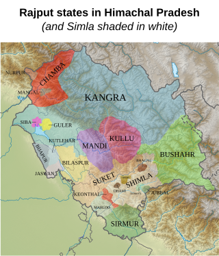
The Rajputs in Himachal Pradesh are members of the Rajput community living in the North Indian Himalayan state of Himachal Pradesh. They ruled a majority of kingdoms of the region and even dominate in Himachal Pradesh politics. The kingdoms of the Hill States of India were mostly in the present day state of Himachal Pradesh, and mostly had Rajput rulers. All of the Chief Ministers who served Himachal Pradesh except for Shanta Kumar belong to the Rajput caste. The Rajputs of Himachal Pradesh fought battles with Tughlaq, Mughal, and Sikh forces, most notable being the Battle of Bhangani, when the Hill States made an alliance against the Sikhs. While some Rajput kingdoms and clans have a long history in Himachal Pradesh, others were established due to the Rajput migrations to the hill regions mostly due to the Islamic invasions.


