
Finland has two official languages, Finnish and Swedish. Many places in the country have different names in Finnish and Swedish, both being official endonyms.
Finland has two official languages, Finnish and Swedish. Many places in the country have different names in Finnish and Swedish, both being official endonyms.
| English name (often the same as the Finnish name) | Finnish name | Swedish name |
|---|---|---|
| Central Finland | Keski-Suomi | Mellersta Finland |
| Central Ostrobothnia | Keski-Pohjanmaa | Mellersta Österbotten |
| Kainuu | Kainuu | Kajanaland |
| Kymenlaakso | Kymenlaakso | Kymmenedalen |
| Lapland | Lappi | Lappland |
| North Karelia | Pohjois-Karjala | Norra Karelen |
| North Ostrobothnia | Pohjois-Pohjanmaa | Norra Österbotten |
| Pohjois-Savo | Pohjois-Savo | Norra Savolax |
| Ostrobothnia | Pohjanmaa | Österbotten |
| Päijät-Häme | Päijät-Häme | Päijänne-Tavastland |
| Pirkanmaa | Pirkanmaa | Birkaland |
| Satakunta | Satakunta | Satakunta |
| South Karelia | Etelä-Karjala | Södra Karelen |
| South Ostrobothnia | Etelä-Pohjanmaa | Södra Österbotten |
| Etelä-Savo | Etelä-Savo | Södra Savolax |
| Southwest Finland | Varsinais-Suomi | Egentliga Finland |
| Kanta-Häme | Kanta-Häme | Egentliga Tavastland |
| Uusimaa | Uusimaa | Nyland |
| Åland [1] | Ahvenanmaa | Åland |
Some Finnish municipalities with endonyms in both Finnish and Swedish, the majority language of the municipality stands first:
In addition to Helsinki other bilingual towns and municipalities in Finland often have bilingual names for districts, villages, and places in nature, such as lakes and rivers. Some examples are:

Helsinki is the capital and most populous city in Finland. It is located on the shore of the Gulf of Finland and serves as the seat of the Uusimaa region in southern Finland. Approximately 675,000 people live in the municipality, with 1.25 million in the capital region, and 1.58 million in the metropolitan area. As the most populous urban area in Finland, it is the country's most significant centre for politics, education, finance, culture, and research. Helsinki is situated 80 kilometres (50 mi) to the north of Tallinn, Estonia, 360 kilometres (220 mi) to the north of Riga, Latvia, 400 kilometres (250 mi) to the east of Stockholm, Sweden, and 300 kilometres (190 mi) to the west of Saint Petersburg, Russia. Helsinki has significant historical connections with these four cities.

Vantaa is a city in Finland. It is located to the north of the capital, Helsinki, in southern Uusimaa. The population of Vantaa is approximately 247,000. It is the 4th most populous municipality in Finland. Vantaa is part of the Helsinki Metropolitan Area, which has approximately 1.58 million inhabitants.

Western Finland was a province of Finland from 1997 to 2009. It bordered the provinces of Oulu, Eastern Finland and Southern Finland. It also bordered the Gulf of Bothnia towards Åland. Tampere was the largest city of the province.

Vuosaari is a neighbourhood in the City of Helsinki, Finland. It is located by the sea in East Helsinki and with its area of 15.38 km2 (5.94 sq mi) is geographically the largest district in the city. It also has two Helsinki Metro stations, Rastila and Vuosaari

Helsinki has a total area of 686 km2 (265 sq mi). 186 km2 (72 sq mi) of it is land and 500 km2 (190 sq mi) of the area is covered with water. It is located at 60°10′N24°56′E.

The Helsinki Metro is a rapid transit system serving the Helsinki capital region, Finland. It is the world's northernmost metro system. It was opened to the general public on 2 August 1982 after 27 years of planning. It is operated by Helsinki City Transport and Metropolitan Area Transport Ltd for Helsinki Regional Transport Authority and carries 92.6 million passengers per year.
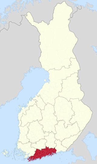
Uusimaa is a region of Finland. It borders the regions of Southwest Finland, Tavastia Proper (Kanta-Häme), Päijänne Tavastia (Päijät-Häme), and Kymenlaakso. Finland's capital and largest city, Helsinki, along with the surrounding metropolitan area, are both contained in the region, and Uusimaa is Finland's most populous region. The population of Uusimaa is 1,734,000.

Pasila station is a railway station in Helsinki, Finland, approximately 3.5 kilometres (2.2 mi) north of Helsinki Central. It is the second busiest railway station in Finland, after Helsinki Central, and takes up a large part of the district of Pasila. The station was first opened in 1862 along the Finnish Main Line. The current station building opened in 2019.

Pasila is a part of Helsinki, Finland, that is both a central-northern neighbourhood and district, bordering the areas of Alppila to the south, the Central Park (Keskuspuisto) to the west, and Vallila to the east.

Public transport in Helsinki consists of bus, tram, metro, local railway and ferry services. The system is managed by the Helsinki Regional Transport Authority and covers Helsinki, Espoo, Kauniainen, Vantaa and the outlying Kerava, Kirkkonummi, Sipoo and Tuusula.
The city of Helsinki, the capital of Finland, can be divided into various sorts of subdivisions. Helsinki is divided into three major areas: Helsinki Downtown, North Helsinki and East Helsinki. The subdivisions include boroughs, districts, major districts and postal code areas. The plethora of different official ways to divide the city is a source of some confusion to the inhabitants, as different kinds of subdivisions often share similar or identical names.
The architecture of Finland has a history spanning over 800 years, and while up until the modern era the architecture was highly influenced by Sweden, there were also influences from Germany and Russia. From the early 19th century onwards influences came directly from further afield: first when itinerant foreign architects took up positions in the country and then when the Finnish architect profession became established.

Munkkiniemi is a neighbourhood in Helsinki. Subdivisions within the district are Vanha Munkkiniemi, Kuusisaari, Lehtisaari, Munkkivuori, Niemenmäki and Talinranta.

The Krepost Sveaborg was an Imperial Russian system of land and coastal fortifications constructed around Helsinki during the First World War. The purpose of the fortress was to provide a secure naval base for the Russian Baltic fleet and to protect Helsinki and block routes to Saint Petersburg from a possible German invasion. Krepost Sveaborg was part of Peter the Great's Naval Fortress, a coastal fortification system protecting access to Saint Petersburg by sea. The central part of Krepost Sveaborg was the old fortress of Suomenlinna where the fortress headquarters were located. Due to technological advances in artillery the old fortress was no longer capable of providing a sufficient protection, and a new main defensive line was built well beyond the old fortress boundaries. New coastal artillery guns built on outlying islands protected Krepost Sveaborg from the sea, while fortified lines constructed around Helsinki were intended to stop any attacks on land. The primary coastal guns were 10 in (254 mm) model 1891 guns and 6 in (152 mm) model 1892 Canet guns. Older 11 in (279 mm) model 1877 guns were also used. In summer 1917 the fortress had two hundred coastal or anti-landing guns, of which 24 were 10-inch guns in six batteries, 16 were 6-inch Canet guns in four batteries and twelve were 11-inch guns in three batteries. The artillery used in land fortifications included older coastal guns, old fixed carriage guns and newer light field guns. In March 1917, Krepost Sveaborg had a total of 463 guns, although many of them were obsolescent. Krepost Sveaborg was still partly incomplete in 1917 when the February Revolution halted most of the construction work. Some further construction work was carried out during the remaining year, but all work halted during the October Revolution. Following the Finnish Declaration of Independence, parts of the land fortifications were used in the Finnish Civil War. The coastal fortifications were later taken over by Finland to protect Helsinki, while the land fortifications were mostly abandoned and disarmed.

Itä-Pasila (Finnish), Östra Böle (Swedish) is a neighborhood in the Pasila subdivision of Helsinki, Finland.

Läntinen suurpiiri is one of the seven major districts of Helsinki, Finland. It covers five subdistricts: Reijola, Munkkiniemi, Haaga, Pitäjänmäki and Kaarela. As of 2005, western major district has 98,545 inhabitants living in an area of 30.4 km2.

Until 2021, Helsinki was Finland's only remaining city with tram traffic. Two other cities—Turku (see Turku tram) and Vyborg —have had tram systems. Vyborg abandoned its trams in 1957 after it was ceded to the Soviet Union after the end of World War II. Turku withdrew its trams in 1972.