Aconcagua is a mountain in the Principal Cordillera of the Andes mountain range, in Mendoza Province, Argentina. It is the highest mountain in the Americas, the highest outside Asia, and the highest in the Southern Hemisphere with a summit elevation of 6,961 metres (22,838 ft). It lies 112 kilometres northwest of the provincial capital, the city of Mendoza, about five kilometres from San Juan Province, and 15 km (9 mi) from Argentina's border with neighbouring Chile. The mountain is one of the Seven Summits of the seven continents.

Reinhold Andreas Messner is an Italian mountaineer, explorer, and author from South Tyrol. He made the first solo ascent of Mount Everest and, along with Peter Habeler, the first ascent of Everest without supplemental oxygen. He was the first climber to ascend all fourteen peaks over 8,000 metres (26,000 ft) above sea level and he also did it without supplementary oxygen. Messner was the first to cross Antarctica and Greenland with neither snowmobiles nor dog sleds and also crossed the Gobi Desert alone. He is widely considered as the greatest mountaineer of all time.

The Matterhorn is a mountain of the Alps, straddling the main watershed and border between Switzerland and Italy. It is a large, near-symmetric pyramidal peak in the extended Monte Rosa area of the Pennine Alps, whose summit is 4,478 metres (14,692 ft) high, making it one of the highest summits in the Alps and Europe. The four steep faces, rising above the surrounding glaciers, face the four compass points and are split by the Hörnli, Furggen, Leone/Lion, and Zmutt ridges. The mountain overlooks the Swiss town of Zermatt, in the canton of Valais, to the northeast; and the Italian town of Breuil-Cervinia in the Aosta Valley to the south. Just east of the Matterhorn is Theodul Pass, the main passage between the two valleys on its north and south sides, which has been a trade route since the Roman Era.

Dhaulagiri is the seventh highest mountain in the world at 8,167 metres (26,795 ft) above sea level, and the highest mountain within the borders of a single country (Nepal). It was first climbed on 13 May 1960 by a Swiss-Austrian-Nepali expedition. Annapurna I is 34 km (21 mi) east of Dhaulagiri. The Kali Gandaki River flows between the two in the Kaligandaki Gorge, said to be the world's deepest. The town of Pokhara is south of the Annapurnas, an important regional center and the gateway for climbers and trekkers visiting both ranges as well as a tourist destination in its own right.

Rakaposhi also known as Dumani is a mountain of the Karakoram range, located in the Nagar valley, Bagrote valley of the Gilgit-Baltistan territory of Pakistan. The mountain is extrememly broad measuring almost 20km from East to West. It is the only peak on Earth that drops directly, uninterrupted, for almost 6000m from the summit to the base.

The Picos de Europa are a mountain range extending for about 20 km (12 mi), forming part of the Cantabrian Mountains in northern Spain. The range is situated in the Autonomous Communities of Asturias, Cantabria and Castile and León. The highest peak is Torre de Cerredo, at an elevation of 2650 m (8,690 ft).

Alexander Huber, is a German rock climber and mountaineer. He became a professional climber in 1997, and was widely regarded as the world's strongest climber in the late-1990s, and is an important figure in rock climbing history. Huber has set records in several different rock climbing disciplines, including extreme free solos, new hardest sport climbing routes, and bold first free ascents in big wall climbing.

The Aiguille de Bionnassay is a mountain in the Mont Blanc massif of the Alps in France and Italy. It has been described as "one of the most attractive satellite peaks of Mont Blanc", and is located on its western side. The mountain's south and east ridges form the frontier between the two countries, and its summit is a knife-edge crest of snow and ice. Reaching it via any route provides a "splendid and serious snow and ice climb".
Fred Rouhling is a French rock climber and boulderer, noted for creating and repeating some of the earliest grade 9a (5.14d) sport climbing routes in the world, including Hugh in 1993, the first-ever French 9a (5.14d) sport route. Rouhling is also known for the controversy from his proposed grading of 9b (5.15b) for his 1995 route Akira, which would have made it the world's first-ever 9b-graded sport route; 25 years later, it was graded at 9a (5.14d).
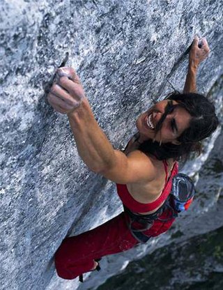
Josune Bereziartu, also known as Josune Bereciartu Urruzola, is a Basque rock climber. For a decade starting in the late 1990s, she was considered the strongest female sport climber in the world and is regarded as one of the most important female rock climbers in history.

Juan Eusebio Oiarzabal Urteaga, commonly known as Juanito Oiarzabal, is a noted Spanish Basque mountaineer. He has written four books on the subject. He was the sixth man to reach all 14 eight-thousander summits, and the third one to reach them without supplementary oxygen. He was the first person to conquer the top three summits twice and was the oldest climber to summit Kangchenjunga, at almost 53, until Carlos Soria Fontan did so in 2014, at 75 years old. In 2004, he lost all his toes to frostbite after summiting K2.

Ortler is, at 3,905 m (12,812 ft) above sea level, the highest mountain in the Eastern Alps outside the Bernina Range. It is the main peak of the Ortler Range. It is the highest point of the Southern Limestone Alps, of South Tyrol in Italy, of Tyrol overall, and, until 1919, of the Austrian-Hungarian empire. In German the mountain is commonly referred to as "König Ortler", like in the unofficial hymn of South Tyrol, the Bozner Bergsteigerlied.

Walter Bonatti was an Italian mountain climber, explorer and journalist. He was noted for many climbing achievements, including a solo climb of a new route on the south-west pillar of the Aiguille du Dru in August 1955, the first ascent of Gasherbrum IV in 1958, and, in 1965, the first solo climb in winter of the North face of the Matterhorn on the mountain's centenary year of its first ascent. Immediately after his solo climb on the Matterhorn, Bonatti announced his retirement from professional climbing at the age of 35, and after 17 years of climbing activity. He authored many mountaineering books and spent the remainder of his career travelling off the beaten track as a reporter for the Italian magazine Epoca. He died on 13 September 2011 of pancreatic cancer in Rome aged 81, and was survived by his life partner, the actress Rossana Podestà.

The Barre des Écrins is a mountain in the French Alps with a peak elevation of 4,102 metres (13,458 ft). It is the highest peak of the Massif des Écrins and the Dauphiné Alps and the most southerly alpine peak in Europe that is higher than 4,000 metres. It is the only 4,000-metre mountain in France that lies outside the Mont Blanc Massif. Before the annexation of Savoy in 1860 it was the highest mountain in France.

ʿAlam-Kūh – Mount Alam – is a mountain in Alborz mountain range in north of Iran, Mazandaran Province, forming a peak of Takht-e Suleyman Massif. It is located in Kelardasht District of Mazandaran Province of Iran. With an elevation of 4,828 meters, it is the second-highest peak in Iran after Mount Damavand.

The Urrieles Massif or the Central Massif is a mountainous massif in the north of Spain, one of the three massifs that make up the Picos de Europa, and in turn, one of the stretches of the Cantabrian Massif belonging to the Cantabrian Range. The other two massifs are the Cornión and Ándara. Of the three, it is the tallest.
Gustav Schulze (1881-1965) was a Mexican-German geologist who was the first scientist to study the geology and paleontology of Picos de Europa and Cantabrian Mountains. Also was the first person who climbed Picu Urriellu alone in 1906.

Hervé Barmasse is an Italian alpinist. He began his career as a mountaineer on his home mountain, the Matterhorn, climbing new routes and repeating various prestigious ones.
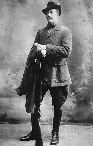
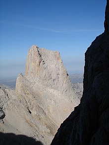
Pedro José Pidal y Bernaldo de Quirós, 1st Marquess of Villaviciosa de Asturias, MP was a Spanish peer, politician, mountaineer, writer, famed hunter and Olympic medalist. A visionary in the field of conservationism, he engineered the creation of Picos de Europa National Park in 1918 and was the first person to reach the summit of Naranjo de Bulnes, in 1904.
The recorded history of climbing of the Eiger mountain in Switzerland starts in the 1800s. It is split between the pre-north face era, when the main summits and easier ridges and faces were climbed, and the post-north face era, when it became one of the greatest prizes in mountaineering. At least sixty-four climbers have died while attempting the ascent.