
A weather station is a facility, either on land or sea, with instruments and equipment for measuring atmospheric conditions to provide information for weather forecasts and to study the weather and climate. The measurements taken include temperature, atmospheric pressure, humidity, wind speed, wind direction, and precipitation amounts. Wind measurements are taken with as few other obstructions as possible, while temperature and humidity measurements are kept free from direct solar radiation, or insolation. Manual observations are taken at least once daily, while automated measurements are taken at least once an hour. Weather conditions out at sea are taken by ships and buoys, which measure slightly different meteorological quantities such as sea surface temperature (SST), wave height, and wave period. Drifting weather buoys outnumber their moored versions by a significant amount.

The National Weather Service (NWS) is an agency of the United States federal government that is tasked with providing weather forecasts, warnings of hazardous weather, and other weather-related products to organizations and the public for the purposes of protection, safety, and general information. It is a part of the National Oceanic and Atmospheric Administration (NOAA) branch of the Department of Commerce, and is headquartered in Silver Spring, Maryland, within the Washington metropolitan area. The agency was known as the United States Weather Bureau from 1890 until it adopted its current name in 1970.

The John C. Stennis Space Center (SSC) is a NASA rocket testing facility in Hancock County, Mississippi, United States, on the banks of the Pearl River at the Mississippi–Louisiana border. As of 2012, it is NASA's largest rocket engine test facility. There are over 50 local, state, national, international, private, and public companies and agencies using SSC for their rocket testing facilities.

A tsunami warning system (TWS) is used to detect tsunamis in advance and issue the warnings to prevent loss of life and damage to property. It is made up of two equally important components: a network of sensors to detect tsunamis and a communications infrastructure to issue timely alarms to permit evacuation of the coastal areas. There are two distinct types of tsunami warning systems: international and regional. When operating, seismic alerts are used to instigate the watches and warnings; then, data from observed sea level height are used to verify the existence of a tsunami. Other systems have been proposed to augment the warning procedures; for example, it has been suggested that the duration and frequency content of t-wave energy is indicative of an earthquake's tsunami potential.

The Pacific Tsunami Warning Center (PTWC), located on Ford Island, Hawaii, is one of two tsunami warning centers in the United States, covering Hawaii, Guam, American Samoa and the Northern Mariana Islands in the Pacific, as well as Puerto Rico, the U.S. Virgin Islands and the British Virgin Islands in the Caribbean Sea. Other parts of the United States are covered by the National Tsunami Warning Center.

Deep-ocean Assessment and Reporting of Tsunamis (DART) is a component of an enhanced tsunami warning system.
Oceanic and Atmospheric Research (OAR) is a division of the National Oceanic and Atmospheric Administration (NOAA). OAR is also referred to as NOAA Research.
The National Severe Storms Laboratory (NSSL) is a National Oceanic and Atmospheric Administration (NOAA) weather research laboratory under the Office of Oceanic and Atmospheric Research. It is one of seven NOAA Research Laboratories (RLs).
The Advanced Very-High-Resolution Radiometer (AVHRR) instrument is a space-borne sensor that measures the reflectance of the Earth in five spectral bands that are relatively wide by today's standards. AVHRR instruments are or have been carried by the National Oceanic and Atmospheric Administration (NOAA) family of polar orbiting platforms (POES) and European MetOp satellites. The instrument scans several channels; two are centered on the red (0.6 micrometres) and near-infrared (0.9 micrometres) regions, a third one is located around 3.5 micrometres, and another two the thermal radiation emitted by the planet, around 11 and 12 micrometres.

Weather buoys are instruments which collect weather and ocean data within the world's oceans, as well as aid during emergency response to chemical spills, legal proceedings, and engineering design. Moored buoys have been in use since 1951, while drifting buoys have been used since 1979. Moored buoys are connected with the ocean bottom using either chains, nylon, or buoyant polypropylene. With the decline of the weather ship, they have taken a more primary role in measuring conditions over the open seas since the 1970s. During the 1980s and 1990s, a network of buoys in the central and eastern tropical Pacific Ocean helped study the El Niño-Southern Oscillation. Moored weather buoys range from 1.5–12 metres (5–40 ft) in diameter, while drifting buoys are smaller, with diameters of 30–40 centimetres (12–16 in). Drifting buoys are the dominant form of weather buoy in sheer number, with 1250 located worldwide. Wind data from buoys has smaller error than that from ships. There are differences in the values of sea surface temperature measurements between the two platforms as well, relating to the depth of the measurement and whether or not the water is heated by the ship which measures the quantity.
The Coastal-Marine Automated Network (C-MAN) is a meteorological observation network along the coastal United States. Consisting of about sixty stations installed on lighthouses, at capes and beaches, on near shore islands, and on offshore platforms, the stations record atmospheric pressure, wind direction, speed and gust, and air temperature; however, some C-MAN stations are designed to also measure sea surface temperature, water level, waves, relative humidity, precipitation, and visibility.

The September 2007 Sumatra earthquakes were a series of megathrust earthquakes that struck the Sunda Trench off the coast of Sumatra, Indonesia, with three of magnitude 7 or greater. A series of tsunami bulletins was issued for the area. The most powerful of the series had a magnitude of 8.5, which makes it in the top 20 of the largest earthquakes ever recorded on a seismograph.

Chesapeake Light is an offshore lighthouse marking the entrance to the Chesapeake Bay. The structure was first marked with a lightship in the 1930s, and was later replaced by a "Texas Tower" in 1965. The lighthouse was eventually automated and was used for supporting atmospheric measurement sites for NASA and NOAA. Due to deteriorating structural conditions, the lighthouse was deactivated in 2016. At the time, it was the last remaining "Texas Tower" still in use due to obsolescence.
The following are considered ocean essential climate variables (ECVs) by the Ocean Observations Panel for Climate (OOPC) that are currently feasible with current observational systems.
The marine optical buoy (MOBY) measures light at and very near the sea surface in a specific location over a long period of time, serving as part of an ocean color observation system. Satellites are another component of the system, providing global coverage through remote sensing; however, satellites measure light above the Earth's atmosphere, becoming subject to interference from the atmosphere itself and other light sources. The Marine Optical Buoy helps alleviate that interference and thus improve the quality of the overall ocean color observation system.

The National Tsunami Warning Center (NTWC) is one of two tsunami warning centers in the United States, covering all coastal regions of the United States and Canada, except Hawaii, Guam, the Northern Mariana Islands, Puerto Rico and the U.S. Virgin Islands. Until 2013, it was known as the West Coast and Alaska Tsunami Warning Center.
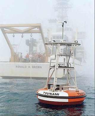
The NOAA Center for Tsunami Research (NCTR), located at the Pacific Marine Environmental Laboratory (PMEL) in Seattle, Washington, performs research in support of tsunami forecast models to increase the speed and accuracy of operational forecasts and warnings, tsunami inundation models to predict tsunami impacts on coastal communities, and tsunami measurement/detection technology for optimally designed networks of tsunami buoys.
There are NASA facilities across the United States and around the world. NASA Headquarters in Washington, DC provides overall guidance and political leadership to the agency. There are 10 NASA field centers, which provide leadership for and execution of NASA's work. All other facilities fall under the leadership of at least one of these field centers. Some facilities serve more than one application for historic or administrative reasons. NASA has used or supported various observatories and telescopes, and an example of this is the NASA Infrared Telescope Facility. In 2013 a NASA Office of the Inspector General's (OIG) Report recommended a Base Realignment and Closure Commission (BRAC) style organization to consolidate NASA's little used facilities. The OIG determined at least 33 of NASA's 155 facilities were underutilized.

USCGC Cypress (WLB-210) is a United States Coast Guard cutter and the tenth Juniper-class seagoing buoy tender. She is outfitted with advanced technological and navigational capabilities that allow her to be positioned correctly for exact placement of buoys through the use of controllable-pitch propellers and stern and bow thrusters.
The Tropical Atmosphere Ocean (TAO) project is a major international effort that instrumented the entire tropical Pacific Ocean with approximately 70 deep ocean moorings. The development of the TAO array in 1985 was motivated by the 1982-1983 El Niño event and ultimately designed for the study of year-to-year climate variations related to El Niño and the Southern Oscillation (ENSO). Led by the TAO Project Office of the Pacific Marine Environmental Laboratory (PMEL), the full array of 70 moorings was completed in 1994.

