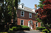
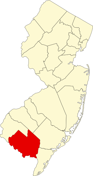
[3] Name on the Register [4] Image Date listed [5] Location City or town Description 1 Abbott Farm Archeological Site Abbott Farm Archeological Site December 8, 1976 (# 76001158 Hamilton-Trenton-Bordentown Marsh, other nearby public and private lands 40°11′10″N 74°43′37″W / 40.186°N 74.727°W / 40.186; -74.727 (Abbott Farm Archeological Site ) Bordentown and Bordentown Township [6] Extends into Mercer County . 2 William R. Allen School William R. Allen School August 8, 1991 (# 90001450 Junction of Mitchell Avenue and East Federal Street 40°04′26″N 74°51′05″W / 40.0739°N 74.8514°W / 40.0739; -74.8514 (William R. Allen School ) Burlington 3 Arney's Mount Friends Meetinghouse and Burial Ground Arney's Mount Friends Meetinghouse and Burial Ground January 18, 1973 (# 73001083 Junction of Mount Holly-Juliustown and Pemberton-Arney's Mount Roads 40°00′33″N 74°41′50″W / 40.0092°N 74.6972°W / 40.0092; -74.6972 (Arney's Mount Friends Meetinghouse and Burial Ground ) Arney's Mount 4 Arneytown Historic District Arneytown Historic District December 12, 1977 (# 67451850 Province Line Road (Ellisdale-Arneytown Road) and Chesterfield-Arneytown Road 40°06′07″N 74°34′07″W / 40.1019°N 74.5686°W / 40.1019; -74.5686 (Arneytown Historic District ) Arneytown Extends into Monmouth County 5 Atsion Village Atsion Village October 22, 1974 (# 74001154 US 206 39°44′27″N 74°43′29″W / 39.7408°N 74.7247°W / 39.7408; -74.7247 (Atsion Village ) Atsion 6 Batsto Village Batsto Village September 10, 1971 (# 71000495 10 miles (16 km) east of Hammonton on CR 542 39°38′28″N 74°38′49″W / 39.641064°N 74.646994°W / 39.641064; -74.646994 (Batsto Village ) Batsto Village 7 Bead Wreck Site Bead Wreck Site October 18, 1988 (# 88001899 Address Restricted New Gretna 8 Beverly National Cemetery Beverly National Cemetery October 15, 1997 (# 97001201 Bridgeboro Road, junction of Mt. Holly, and Bridgeboro Roads 40°03′16″N 74°55′14″W / 40.054444°N 74.920556°W / 40.054444; -74.920556 (Beverly National Cemetery ) Edgewater Park Township 9 Birmingham School Birmingham School December 31, 1992 (# 92001683 Birmingham Road, north of North Branch Rancocas Creek 39°58′47″N 74°42′40″W / 39.979722°N 74.711111°W / 39.979722; -74.711111 (Birmingham School ) Birmingham Destroyed by fire in July 1993 10 Bishop–Irick Farmstead Bishop–Irick Farmstead August 4, 1992 (# 92000975 17 Pemberton Road 39°56′23″N 74°44′44″W / 39.939722°N 74.745556°W / 39.939722; -74.745556 (Bishop–Irick Farmstead ) Vincentown 11 Bordentown Historic District Bordentown Historic District June 14, 1982 (# 82003264 In an irregular pattern within the city limits 40°08′47″N 74°42′41″W / 40.146389°N 74.711389°W / 40.146389; -74.711389 (Bordentown Historic District ) Bordentown Boundary increase 2014-09-03. 12 Breidenhart Breidenhart December 22, 1977 (# 77000851 255 East Main Street 39°58′09″N 74°56′08″W / 39.969167°N 74.935556°W / 39.969167; -74.935556 (Breidenhart ) Moorestown Township 13 J. F. Budd Baby Shoe Factory J. F. Budd Baby Shoe Factory December 13, 2000 (# 00001525 231 Penn Avenue 40°04′51″N 74°51′15″W / 40.080789°N 74.854297°W / 40.080789; -74.854297 (J. F. Budd Baby Shoe Factory ) Burlington 14 Burlington County Prison Burlington County Prison June 24, 1986 (# 86003558 High Street 39°59′47″N 74°47′23″W / 39.9964°N 74.7897°W / 39.9964; -74.7897 (Burlington County Prison ) Mount Holly Township 15 Burlington Historic District Burlington Historic District March 13, 1975 (# 75001124 Roughly L-shaped, bounded by the Delaware River and High, West Broad, Talbot, and Reed Streets 40°04′43″N 74°51′50″W / 40.0786°N 74.8639°W / 40.0786; -74.8639 (Burlington Historic District ) Burlington 16 Burlington's Lost Burial Ground Burlington's Lost Burial Ground November 26, 2004 (# 04001260 Address Restricted 40°04′44″N 74°51′37″W / 40.0789°N 74.8603°W / 40.0789; -74.8603 (Burlington's Lost Burial Ground ) Burlington 17 Buzby's General Store Buzby's General Store March 25, 2004 (# 04000222 3959 CR 563 39°49′09″N 74°32′08″W / 39.819167°N 74.535556°W / 39.819167; -74.535556 (Buzby's General Store ) Woodland Township 18 Chesterford School Chesterford School December 23, 2009 (# 09001155 415 W. Main St. 39°57′19″N 75°00′32″W / 39.9552°N 75.0089°W / 39.9552; -75.0089 (Chesterford School ) Maple Shade 19 Cinnaminson Avenue and Spring Garden Street Schools Cinnaminson Avenue and Spring Garden Street Schools May 29, 1992 (# 92000635 Spring Garden Street between Cinnaminson and Parry Avenues 39°59′49″N 75°01′15″W / 39.996944°N 75.020833°W / 39.996944; -75.020833 (Cinnaminson Avenue and Spring Garden Street Schools ) Palmyra 20 Isaac Collins House Isaac Collins House July 24, 1992 (# 92000926 201 Broad Street 40°04′42″N 74°52′01″W / 40.078333°N 74.866944°W / 40.078333; -74.866944 (Isaac Collins House ) Burlington 21 Benjamin Cooper Farm Benjamin Cooper Farm December 12, 1978 (# 78001744 Address Restricted Moorestown Township Known also as Savich Farm, no buildings on site. 22 Coopertown Meetinghouse Coopertown Meetinghouse May 22, 1978 (# 78001750 Northwest of Willingboro on Cooper Street 40°02′55″N 74°54′16″W / 40.048611°N 74.904444°W / 40.048611; -74.904444 (Coopertown Meetinghouse ) Willingboro Township 23 Cropwell Friends Meeting House Cropwell Friends Meeting House August 14, 1992 (# 92000976 810 Cropwell Road 39°53′36″N 74°55′32″W / 39.8933°N 74.9256°W / 39.8933; -74.9256 (Cropwell Friends Meeting House ) Evesham Township 24 Crosswicks Historic District Crosswicks Historic District May 3, 1976 (# 76001146 Roughly bounded by Bordentown-Crosswicks and Ellisdale Roads 40°09′07″N 74°38′47″W / 40.151944°N 74.646389°W / 40.151944; -74.646389 (Crosswicks Historic District ) Crosswicks 25 Crosswicks Creek Site III Crosswicks Creek Site III November 26, 1990 (# 87001795 Address Restricted Bordentown Extends into Mercer County 26 Eayres Plantation and Mill Site Eayres Plantation and Mill Site August 13, 1986 (# 86001501 Eayrestown-Red Lion and East Bella Bridge Roads 39°56′48″N 74°47′41″W / 39.946667°N 74.794722°W / 39.946667; -74.794722 (Eayres Plantation and Mill Site ) Lumberton Township 27 Amos Evans House Amos Evans House September 2, 1994 (# 94001008 501 East Main Street 39°53′05″N 74°53′49″W / 39.884722°N 74.896944°W / 39.884722; -74.896944 (Amos Evans House ) Evesham Township 28 William and Susan Evans House William and Susan Evans House August 14, 1992 (# 92000978 2 Bill's Lane, Marlton 39°52′24″N 74°54′12″W / 39.873333°N 74.903333°W / 39.873333; -74.903333 (William and Susan Evans House ) Evesham Township 29 Evans-Cooper House Evans-Cooper House August 26, 1993 (# 93000868 North Elmwood Road between NJ 70 and Marlton Pike 39°53′22″N 74°53′07″W / 39.889444°N 74.885278°W / 39.889444; -74.885278 (Evans-Cooper House ) Evesham Township 30 Thomas and Mary Evens House Thomas and Mary Evens House August 26, 1993 (# 93000867 South Elmwood Road 39°52′51″N 74°53′19″W / 39.880833°N 74.888611°W / 39.880833; -74.888611 (Thomas and Mary Evens House ) Evesham Township 31 Evesham Friends Meeting House Evesham Friends Meeting House April 22, 1982 (# 82003268 Moorestown-Mt. Laurel and Hainesport-Mt. Laurel Roads (Evesboro Road) 39°56′05″N 74°53′32″W / 39.934722°N 74.892222°W / 39.934722; -74.892222 (Evesham Friends Meeting House ) Mount Laurel Township 32 Farmer's Hall Farmer's Hall August 1, 1979 (# 79003248 Moorestown-Mt. Laurel and Hainesport-Mt. Laurel Roads (Evesboro Road) 39°56′02″N 74°53′32″W / 39.933889°N 74.892222°W / 39.933889; -74.892222 (Farmer's Hall ) Mount Laurel Township 33 Fenwick Manor Fenwick Manor October 25, 1990 (# 90001549 15 Springfield Road 39°57′53″N 74°37′44″W / 39.964722°N 74.628889°W / 39.964722; -74.628889 (Fenwick Manor ) Pemberton Township 34 Fernbrook Historic District Fernbrook Historic District July 7, 2022 (# 100007873 142-150 Bordentown-Georgetown Road 40°06′14″N 74°40′37″W / 40.1039°N 74.6769°W / 40.1039; -74.6769 (Fernbrook Historic District ) Chesterfield Township Known as Fernbrook Farms 35 Florence Public School No. 1 Florence Public School No. 1 June 8, 2015 (# 15000321 203 W. 2nd St. 40°07′19″N 74°48′27″W / 40.122°N 74.8074°W / 40.122; -74.8074 (Florence Public School No. 1 ) Florence Township 36 Thomas French Jr. House Thomas French Jr. House January 9, 1978 (# 78001745 512 Camden Avenue 39°57′29″N 74°58′00″W / 39.958056°N 74.966667°W / 39.958056; -74.966667 (Thomas French Jr. House ) Moorestown Township 37 Gen. Edward S. Godfrey House Gen. Edward S. Godfrey House February 28, 1997 (# 97000064 27 Main Street 40°02′50″N 74°33′52″W / 40.047222°N 74.564444°W / 40.047222; -74.564444 (Gen. Edward S. Godfrey House ) Cookstown 38 Green Hill Farm Green Hill Farm July 8, 1982 (# 82003265 Oxmead and Deacon Roads 40°02′43″N 74°48′54″W / 40.045278°N 74.815°W / 40.045278; -74.815 (Green Hill Farm ) Burlington Township 39 Jonathan Haines House Jonathan Haines House June 16, 1976 (# 76001147 Northeast of Medford on Fostertown Road 39°56′29″N 74°47′05″W / 39.941389°N 74.784722°W / 39.941389; -74.784722 (Jonathan Haines House ) Medford 40 Hanover Furnace Hanover Furnace March 1, 1974 (# 74001155 Address Restricted Browns Mills 41 High Street Historic District High Street Historic District December 15, 1993 (# 93001386 Roughly, High Street from Pearl Street to Federal Street; 6 West Pearl Street 40°04′38″N 74°51′31″W / 40.0772°N 74.8586°W / 40.0772; -74.8586 (High Street Historic District ) Burlington Boundary increased 8/25/14. 42 Thomas Hollinshead House Thomas Hollinshead House August 14, 1992 (# 92000977 18 West Stow Road 39°54′47″N 74°55′26″W / 39.913056°N 74.923889°W / 39.913056; -74.923889 (Thomas Hollinshead House ) Marlton 43 James and Charles B. Holloway Farm Complex James and Charles B. Holloway Farm Complex July 8, 1982 (# 82003266 Newbold Lane 40°06′47″N 74°38′59″W / 40.113056°N 74.649722°W / 40.113056; -74.649722 (James and Charles B. Holloway Farm Complex ) Chesterfield Township 44 Francis Hopkinson House Francis Hopkinson House July 17, 1971 (# 71000496 101 Farnsworth Avenue at Park Avenue 40°08′54″N 74°42′50″W / 40.148333°N 74.713889°W / 40.148333; -74.713889 (Francis Hopkinson House ) Bordentown 45 John Inskeep Homestead John Inskeep Homestead August 26, 1993 (# 93000866 70 North Locust Ave 39°53′50″N 74°55′00″W / 39.897222°N 74.916667°W / 39.897222; -74.916667 (John Inskeep Homestead ) Marlton 46 John Irick House John Irick House September 16, 1977 (# 77000849 East of Burlington, off of the New Jersey Turnpike 40°03′02″N 74°45′48″W / 40.050556°N 74.763333°W / 40.050556; -74.763333 (John Irick House ) Burlington 47 Ivins-Conover House Ivins-Conover House April 29, 1977 (# 77000852 North of Moorestown off U.S. 130 on Cox Road 40°00′10″N 74°55′07″W / 40.002778°N 74.918611°W / 40.002778; -74.918611 (Ivins-Conover House ) Moorestown Township 48 Jacob's Chapel A.M.E. Church Jacob's Chapel A.M.E. Church November 10, 2015 (# 13000137 311-313 Elbo Ln. 39°55′47″N 74°53′07″W / 39.9298°N 74.8852°W / 39.9298; -74.8852 (Jacob's Chapel A.M.E. Church ) Mount Laurel vicinity 49 Benjamin Jones House Benjamin Jones House November 30, 1982 (# 82001042 Pemberton-Browns Mills Road 39°58′12″N 74°37′31″W / 39.97°N 74.625278°W / 39.97; -74.625278 (Benjamin Jones House ) Pemberton 50 Kirby's Mill Kirby's Mill August 12, 1971 (# 71000497 Northeast of Medford at Church and Fostertown Roads 39°55′00″N 74°48′22″W / 39.916667°N 74.806111°W / 39.916667; -74.806111 (Kirby's Mill ) Medford 51 Log Cabin Lodge Log Cabin Lodge April 12, 1982 (# 82003267 Stokes and Tabernacle Roads 39°51′49″N 74°48′21″W / 39.863611°N 74.805833°W / 39.863611; -74.805833 (Log Cabin Lodge ) Medford Lakes Burned down in 1998, photo is of replacement building 52 Main Street Friends Meeting House Main Street Friends Meeting House August 24, 2011 (# 11000589 19 South St. 39°53′50″N 74°49′24″W / 39.897222°N 74.823333°W / 39.897222; -74.823333 (Main Street Friends Meeting House ) Medford vicinity 53 Moorestown Friends School and Meetinghouse Moorestown Friends School and Meetinghouse July 22, 1988 (# 86003796 Main Street at Chester Avenue 39°57′49″N 74°56′30″W / 39.963611°N 74.941667°W / 39.963611; -74.941667 (Moorestown Friends School and Meetinghouse ) Moorestown Township 54 Moorestown Historic District Moorestown Historic District August 30, 1990 (# 89002295 Roughly bounded by Maple Avenue, Chestnust Avenue, Main Street from Zelley Avenue to Locust Street, and Mill Street 39°57′58″N 74°56′13″W / 39.966111°N 74.936944°W / 39.966111; -74.936944 (Moorestown Historic District ) Moorestown Township 55 Morris Mansion and Mill Morris Mansion and Mill September 13, 1977 (# 77000855 Hanover Street 39°58′15″N 74°41′04″W / 39.970833°N 74.684444°W / 39.970833; -74.684444 (Morris Mansion and Mill ) Pemberton 56 Mount Holly Historic District Mount Holly Historic District February 20, 1973 (# 73001084 Roughly bounded by Prospect, Elm and Top-E-Toy Streets, railroad tracks, Madison and Clifton Avenues 39°59′37″N 74°47′16″W / 39.993611°N 74.787778°W / 39.993611; -74.787778 (Mount Holly Historic District ) Mount Holly Township 57 New Jersey Manual Training and Industrial School for Colored Youth New Jersey Manual Training and Industrial School for Colored Youth January 5, 1998 (# 97001563 North of Burlington Road, west of I-295 40°08′29″N 74°43′25″W / 40.1414°N 74.7236°W / 40.1414; -74.7236 (New Jersey Manual Training and Industrial School for Colored Youth ) Bordentown 58 New St. Mary's Episcopal Church New St. Mary's Episcopal Church May 31, 1972 (# 72000770 North side of Broad Street between Talbot and Wood Streets 40°04′37″N 74°51′43″W / 40.0769°N 74.8619°W / 40.0769; -74.8619 (New St. Mary's Episcopal Church ) Burlington 59 Barzillai Newbold House Barzillai Newbold House January 26, 1978 (# 78001749 East of Columbus on Columbus-Georgetown Roads 40°03′56″N 74°40′04″W / 40.065556°N 74.667778°W / 40.065556; -74.667778 (Barzillai Newbold House ) Columbus 60 William and Susannah Newbold House William and Susannah Newbold House September 29, 1980 (# 80002472 East of Georgetown 40°04′55″N 74°37′41″W / 40.081944°N 74.628056°W / 40.081944; -74.628056 (William and Susannah Newbold House ) Georgetown 61 North Pemberton Railroad Station North Pemberton Railroad Station May 23, 1978 (# 78001746 Hanover Street 39°58′36″N 74°40′54″W / 39.976667°N 74.681667°W / 39.976667; -74.681667 (North Pemberton Railroad Station ) Pemberton 1892-built former Pennsylvania Railroad station 62 Oakwood Oakwood January 30, 1978 (# 78001751 West of Wrightstown on Springfield Meeting Road 40°03′07″N 74°38′21″W / 40.051944°N 74.639167°W / 40.051944; -74.639167 (Oakwood ) Springfield Township Destroyed by fire July 20, 2002 63 Old Schoolhouse Old Schoolhouse November 26, 2008 (# 08001108 35 Brainerd Street 39°59′41″N 74°47′12″W / 39.994797°N 74.786575°W / 39.994797; -74.786575 (Old Schoolhouse ) Mount Holly Township 64 Alice Paul Birthplace Alice Paul Birthplace July 5, 1989 (# 89000774 128 Hooton Road 39°57′24″N 74°55′50″W / 39.956667°N 74.930556°W / 39.956667; -74.930556 (Alice Paul Birthplace ) Mount Laurel Township Also known as Paulsdale 65 Peachfield Peachfield June 19, 1973 (# 73001085 N of Mount Holly on Burr Rd. 40°02′06″N 74°48′09″W / 40.035°N 74.8025°W / 40.035; -74.8025 (Peachfield ) Mount Holly Township 66 Pearson-How, Cooper, and Lawrence Houses Pearson-How, Cooper, and Lawrence Houses April 26, 1978 (# 78001743 453– 459 High Street 40°04′33″N 74°51′27″W / 40.0758°N 74.8575°W / 40.0758; -74.8575 (Pearson-How, Cooper, and Lawrence Houses ) Burlington 67 Pemberton Historic District Pemberton Historic District March 22, 1989 (# 88000688 Roughly bounded by Budd Avenue, Budd's Run, Egbert and Cedar Road, and Rancocas Creek and NJ Central Power and Light Company 39°58′12″N 74°41′01″W / 39.97°N 74.683611°W / 39.97; -74.683611 (Pemberton Historic District ) Pemberton Includes Morris Mansion and Mill 68 Perkins House Perkins House September 15, 1977 (# 77000853 Camden Avenue and King's Highway 39°57′34″N 74°57′32″W / 39.959444°N 74.958889°W / 39.959444; -74.958889 (Perkins House ) Moorestown Township 69 Philadelphia Watch Case Company Building Philadelphia Watch Case Company Building January 31, 1978 (# 78001747 Pavilion and Lafayette Avenues 40°02′24″N 74°57′34″W / 40.04°N 74.959444°W / 40.04; -74.959444 (Philadelphia Watch Case Company Building ) Riverside Township 70 Point Breeze Point Breeze August 10, 1977 (# 77000848 US 206 and Park Street 40°09′22″N 74°42′30″W / 40.156111°N 74.708333°W / 40.156111; -74.708333 (Point Breeze ) Bordentown Former estate of Joseph Bonaparte 71 The Protestant Community Church of Medford Lakes The Protestant Community Church of Medford Lakes July 3, 2017 (# 100001263 100 Stokes Rd. 39°51′44″N 74°48′19″W / 39.862238°N 74.805308°W / 39.862238; -74.805308 (The Protestant Community Church of Medford Lakes ) Medford Lakes 72 Providence Presbyterian Church of Bustleton Providence Presbyterian Church of Bustleton November 18, 1988 (# 87000377 Junction of Old York and Burlington-Bustleton Roads 40°05′16″N 74°47′02″W / 40.0878°N 74.7839°W / 40.0878; -74.7839 (Providence Presbyterian Church of Bustleton ) Roebling 73 Quaker School Quaker School December 31, 1974 (# 74001156 York and Penn Streets 40°04′48″N 74°51′22″W / 40.08°N 74.8561°W / 40.08; -74.8561 (Quaker School ) Burlington 74 Rancocas Historic Village Rancocas Historic Village June 5, 1975 (# 75001126 Irregular pattern bounded north and west by Willingboro line, east to Springside Road and south to 3rd Street 40°00′37″N 74°52′01″W / 40.0103°N 74.8669°W / 40.0103; -74.8669 (Rancocas Historic Village ) Rancocas 75 Recklesstown Historic District Recklesstown Historic District August 19, 1975 (# 75001125 Present town of Chesterfield along Chesterfield-Georgetown Road and CR 528 40°06′49″N 74°38′15″W / 40.1136°N 74.6375°W / 40.1136; -74.6375 (Recklesstown Historic District ) Chesterfield 76 Red Dragon Canoe Club Red Dragon Canoe Club February 2, 2001 (# 01000041 221 Edgewater Avenue 40°04′11″N 74°53′53″W / 40.069722°N 74.898056°W / 40.069722; -74.898056 (Red Dragon Canoe Club ) Edgewater Park Township 77 William Ridgeway House William Ridgeway House January 11, 2019 (# 100003304 149 Juliustown Road 40°00′45″N 74°42′31″W / 40.012441°N 74.708651°W / 40.012441; -74.708651 (William Ridgeway House ) Springfield Township 78 Riverton Historic District Riverton Historic District March 5, 1999 (# 99000271 Roughly bounded by the Delaware River , Park Avenue, Thomas Avenue, and Fulton Street 40°00′33″N 75°00′50″W / 40.009167°N 75.013889°W / 40.009167; -75.013889 (Riverton Historic District ) Riverton 79 Roebling Historic District Roebling Historic District May 22, 1978 (# 78001748 Roughly bounded by Roebling Park, South Street, 2nd and 8th Avenues, Roland Street, Alden, Norman Railroad, and Amboy Avenue 40°07′01″N 74°46′30″W / 40.116944°N 74.775°W / 40.116944; -74.775 (Roebling Historic District ) Roebling 80 Rosebud Farm Rosebud Farm August 17, 1979 (# 79003249 East of Jobstown on Springfield Meetinghouse Road 40°02′19″N 74°39′42″W / 40.038611°N 74.661667°W / 40.038611; -74.661667 (Rosebud Farm ) Jobstown 81 Schoolhouse Schoolhouse April 21, 1975 (# 75001123 2 miles (3.2 km) east of Bridgeboro on Salem Road 40°01′49″N 74°53′46″W / 40.030278°N 74.896111°W / 40.030278; -74.896111 (Schoolhouse ) Bridgeboro 82 Shamong Hotel Shamong Hotel September 13, 1979 (# 79001477 Main Street 39°49′05″N 74°32′08″W / 39.818056°N 74.535556°W / 39.818056; -74.535556 (Shamong Hotel ) Chatsworth 83 Singleton-Lathem-Large House Singleton-Lathem-Large House March 7, 1979 (# 79001478 Northwest of Chesterfield on CR 528 40°08′33″N 74°40′46″W / 40.1425°N 74.679444°W / 40.1425; -74.679444 (Singleton-Lathem-Large House ) Chesterfield Township 84 Smith Mansion Smith Mansion October 22, 1976 (# 76001148 12 High Street 39°57′46″N 74°56′51″W / 39.962778°N 74.9475°W / 39.962778; -74.9475 (Smith Mansion ) Moorestown Township 85 Thomas Smith House Thomas Smith House September 27, 1990 (# 90001437 1645 Hainesport-Mt. Laurel Road 39°55′08″N 74°54′58″W / 39.918889°N 74.916111°W / 39.918889; -74.916111 (Thomas Smith House ) Mount Laurel Township 86 Smithville Historic District Smithville Historic District May 12, 1977 (# 77000856 Smithville Rd., Forest, Railroad, Park, and Maple Aves., River St., and Smithville Lake 39°58′57″N 74°45′04″W / 39.9825°N 74.7511°W / 39.9825; -74.7511 (Smithville Historic District ) Smithville 87 St. Mary of the Lakes Catholic Church St. Mary of the Lakes Catholic Church April 27, 2007 (# 07000357 108 Stokes Road 39°51′45″N 74°48′19″W / 39.8625°N 74.805278°W / 39.8625; -74.805278 (St. Mary of the Lakes Catholic Church ) Medford Lakes 88 St. Stephens Episcopal Church St. Stephens Episcopal Church November 25, 1999 (# 99001363 158 Warren Street 40°03′52″N 74°55′01″W / 40.064444°N 74.916944°W / 40.064444; -74.916944 (St. Stephens Episcopal Church ) Beverly City 89 Springside Public School Springside Public School March 17, 2015 (# 15000091 1508 Mount Holly Rd. 40°03′27″N 74°50′51″W / 40.0575°N 74.8474°W / 40.0575; -74.8474 (Springside Public School ) Burlington Township 90 Dr. James Still Office Dr. James Still Office November 3, 1995 (# 95001190 209 Church Road 39°54′56″N 74°49′29″W / 39.915556°N 74.824722°W / 39.915556; -74.824722 (Dr. James Still Office ) Medford 91 Charles Stokes House Charles Stokes House August 12, 1993 (# 93000827 600 Beverly-Rancocas Road, Willingboro Township 40°00′44″N 74°52′30″W / 40.012222°N 74.875°W / 40.012222; -74.875 (Charles Stokes House ) Willingboro Township 92 Stokes–Evans House Stokes–Evans House August 30, 1994 (# 94001009 52 East Main Street 39°53′26″N 74°55′03″W / 39.890556°N 74.9175°W / 39.890556; -74.9175 (Stokes–Evans House ) Marlton 93 Taylor-Newbold House Taylor-Newbold House November 18, 1988 (# 87001815 Off Old York Road (CR 660 ) 40°06′56″N 74°40′06″W / 40.115556°N 74.668333°W / 40.115556; -74.668333 (Taylor-Newbold House ) Chesterfield Township 94 Town Hall Town Hall August 10, 1977 (# 77000854 40 East Main Street 39°57′51″N 74°56′42″W / 39.964167°N 74.945°W / 39.964167; -74.945 (Town Hall ) Moorestown Township 95 Upper Springfield Meetinghouse Upper Springfield Meetinghouse August 24, 1979 (# 79001479 West of Wrightstown 40°02′40″N 74°38′30″W / 40.044444°N 74.641667°W / 40.044444; -74.641667 (Upper Springfield Meetinghouse ) Wrightstown 96 Vincentown Historic District Vincentown Historic District September 21, 1988 (# 87002107 Roughly bounded by Mill, Church, Pleasant, Main, and Race Streets, and Red Lion Road 39°56′05″N 74°45′02″W / 39.934722°N 74.750556°W / 39.934722; -74.750556 (Vincentown Historic District ) Vincentown 97 West Hill West Hill December 18, 2013 (# 13000944 1114 Oxmead Rd. 40°03′17″N 74°49′38″W / 40.054786°N 74.827132°W / 40.054786; -74.827132 (West Hill ) Burlington 98 Whitesbog Historic District Whitesbog Historic District October 27, 1988 (# 88002115 North of NJ 70 and south of Fort Dix 39°57′34″N 74°30′34″W / 39.959503°N 74.509533°W / 39.959503; -74.509533 (Whitesbog Historic District ) Browns Mills Extends into Ocean County 99 Jacob Wills House Jacob Wills House November 1, 1990 (# 89002296 Brick Road, west of Evans Road 39°52′46″N 74°54′02″W / 39.879444°N 74.900556°W / 39.879444; -74.900556 (Jacob Wills House ) Evesham Township 100 Zurbrugg Mansion Zurbrugg Mansion August 28, 2009 (# 09000651 531 Delaware Avenue 40°03′03″N 74°37′53″W / 40.050833°N 74.631389°W / 40.050833; -74.631389 (Zurbrugg Mansion ) Delanco