National Register of Historic Places listings in Carlton County, Minnesota

Last updated

Location of Carlton County in Minnesota Map of Minnesota highlighting Carlton County.svg
Location of Carlton County in Minnesota

This is a list of the National Register of Historic Places listings in Carlton County, Minnesota. It is intended to be a complete list of the properties and districts on the National Register of Historic Places in Carlton County, Minnesota, United States. The locations of National Register properties and districts for which the latitude and longitude coordinates are included below, may be seen in an online map.

Contents

There are 15 properties and districts listed on the National Register in the county. A supplementary list includes one additional site that was formerly listed on the National Register.


    This National Park Service list is complete through NPS recent listings posted August 18, 2023. [1]

Current listings

Map all coordinates using: OpenStreetMap
[2] Name on the RegisterImageDate listed [3] Location City or townDescription
1 Carlton County Courthouse
Carlton County Courthouse Carlton Courthouse 002.JPG
Carlton County Courthouse
August 29, 1985
(#85001926)
301 Walnut Avenue
46°39′54″N92°25′28″W / 46.665°N 92.4244°W / 46.665; -92.4244 (Carlton County Courthouse)
Carlton County courthouse built 1922–24, one of Carlton County's most prominent public buildings, the longstanding seat of its government, and a work of notable Duluth architect Clyde Kelly. [4]
2 Church of Sts. Joseph and Mary-Catholic
Church of Sts. Joseph and Mary-Catholic St. Joseph and Mary Church, Mission Road, Cloquet.jpg
Church of Sts. Joseph and Mary-Catholic
March 29, 1984
(#84001409)
Mission Road
46°41′03″N92°38′12″W / 46.6842°N 92.6367°W / 46.6842; -92.6367 (Church of Sts. Joseph and Mary-Catholic)
Sawyer 1884 church expanded in the 1920s, one of the state's oldest Catholic churches built by an Ojibwe parish, one of the oldest churches in northern Minnesota overall, and one of Carlton County's few historic buildings to predate the 1918 Cloquet Fire. [5]
3 Cloquet City Hall
Cloquet City Hall Cloquet City Hall.jpg
Cloquet City Hall
September 11, 1985
(#85002312)
Avenue B and Arch Street
46°43′24″N92°27′54″W / 46.7232°N 92.4650°W / 46.7232; -92.4650 (Cloquet City Hall)
Cloquet 1920 city hall, a governmental source and architectural symbol of reconstruction efforts after the 1918 Cloquet Fire destroyed most of the community. [6]
4 Cloquet High School
Cloquet High School CarltonLofts.jpg
Cloquet High School
April 5, 2021
(#100006356)
509 Carlton Ave.
46°43′04″N92°27′30″W / 46.7178°N 92.4584°W / 46.7178; -92.4584 (Cloquet High School)
Cloquet The former high school building has been converted into apartments, called Carlton Lofts.
5 Cloquet-Northern Office Building
Cloquet-Northern Office Building Cloquet-Northern Office Building.jpg
Cloquet-Northern Office Building
August 29, 1985
(#85001925)
Avenue C and Arch Street
46°43′21″N92°27′53″W / 46.7224°N 92.4647°W / 46.7224; -92.4647 (Cloquet-Northern Office Building)
Cloquet 1919 office building—Cloquet's largest from the construction boom after the 1918 fire—which housed nearly all of the lumber town's principal businesses. [7]
6 Grand Portage of the St. Louis River
Grand Portage of the St. Louis River GrandPortageTrailJayCookeStateParkMN.jpg
Grand Portage of the St. Louis River
May 24, 1973
(#73000966)
West of Duluth in Jay Cooke State Park off Minnesota Highway 210
46°40′23″N92°19′17″W / 46.6731°N 92.3214°W / 46.6731; -92.3214 (Grand Portage of the St. Louis River)
Duluth vicinity7-mile (11 km) portage on a crucial Native American and fur trade-era route between the Great Lakes and Mississippi River basins. [8]
7 Jay Cooke State Park CCC/Rustic Style Historic District
Jay Cooke State Park CCC/Rustic Style Historic District River Inn Jay Cooke.JPG
Jay Cooke State Park CCC/Rustic Style Historic District
June 11, 1992
(#89001665)
Off Minnesota Highway 210 east of Carlton
46°39′15″N92°22′17″W / 46.6543°N 92.3713°W / 46.6543; -92.3713 (Jay Cooke State Park CCC/Rustic Style Historic District)
Carlton vicinityExemplary suspension bridge built in 1934 and inn built 1940–42, associated with New Deal federal work relief, the development a major Minnesota state park, and National Park Service rustic architecture. [9]
8 Jay Cooke State Park CCC/WPA/Rustic Style Picnic Grounds
Jay Cooke State Park CCC/WPA/Rustic Style Picnic Grounds Jay Cooke State Park water tower.JPG
Jay Cooke State Park CCC/WPA/Rustic Style Picnic Grounds
June 11, 1992
(#92000640)
Off Minnesota Highway 210 southeast of Forbay Lake
46°39′20″N92°21′08″W / 46.6556°N 92.3522°W / 46.6556; -92.3522 (Jay Cooke State Park CCC/WPA/Rustic Style Picnic Grounds)
Carlton vicinityThree park facilities constructed 1934–36, associated with New Deal federal work relief, the development a major Minnesota state park, and National Park Service rustic architecture. [10]
9 Jay Cooke State Park CCC/WPA/Rustic Style Service Yard
Jay Cooke State Park CCC/WPA/Rustic Style Service Yard SuperintendentCabinJayCookStateParkMN.jpg
Jay Cooke State Park CCC/WPA/Rustic Style Service Yard
June 11, 1992
(#92000642)
Off Minnesota Highway 210 east of Forbay Lake
46°39′40″N92°20′50″W / 46.6611°N 92.3472°W / 46.6611; -92.3472 (Jay Cooke State Park CCC/WPA/Rustic Style Service Yard)
Carlton vicinityTwo park buildings constructed 1934–35, associated with New Deal federal work relief, the development a major Minnesota state park, and National Park Service rustic architecture. [11]
10 Lindholm Oil Company Service Station
Lindholm Oil Company Service Station FLWrightServiceStationCloquetMN.jpg
Lindholm Oil Company Service Station
September 11, 1985
(#85002202)
202 Cloquet Avenue
46°43′17″N92°27′39″W / 46.7214°N 92.4608°W / 46.7214; -92.4608 (Lindholm Oil Company Service Station)
Cloquet World's only gas station built from a design by Frank Lloyd Wright, constructed in 1958 and an influence on subsequent Phillips 66 stations. [12]
11 Minneapolis, St. Paul and Sault Ste. Marie Depot
Minneapolis, St. Paul and Sault Ste. Marie Depot Moose Lake Soo Depot 1.jpg
Minneapolis, St. Paul and Sault Ste. Marie Depot
March 17, 1994
(#86003813)
840 Folz Boulevard
46°27′14″N92°46′07″W / 46.4539°N 92.7686°W / 46.4539; -92.7686 (Minneapolis, St. Paul and Sault Ste. Marie Depot)
Moose Lake 1907 first-class railway station that served an important junction for passengers, grain, and iron ore, and provided emergency housing for people left homeless by the 1918 Cloquet Fire. [13] Now houses a local history museum. [14]
12 Northeastern Hotel
Northeastern Hotel Northeastern Hotel MN.jpg
Northeastern Hotel
November 8, 1984
(#84000218)
115 Saint Louis Avenue
46°43′33″N92°27′49″W / 46.7257°N 92.4636°W / 46.7257; -92.4636 (Northeastern Hotel)
Cloquet 1904 hotel and bar on a river island, remnant of a lumber-era saloon district and temporary site of a hospital and post office in the aftermath of the 1918 Cloquet Fire. [15]
13 Henry C. Oldenburg House
Henry C. Oldenburg House Oldenburg House 3.jpg
Henry C. Oldenburg House
December 27, 2006
(#06001183)
604 Chestnut Street
46°39′49″N92°25′06″W / 46.6637°N 92.4182°W / 46.6637; -92.4182 (Henry C. Oldenburg House)
Carlton 1894 house of politician and attorney Henry C. Oldenburg (1858–1926), an influential local figure in Carlton County's development and the emerging conservation movement. [16]
14 Park Place Historic District
Park Place Historic District ParkPlaceCloquetMN.jpg
Park Place Historic District
August 29, 1985
(#85001924)
1, 512, 520, and 528 Park Place
46°43′16″N92°28′08″W / 46.7212°N 92.4689°W / 46.7212; -92.4689 (Park Place Historic District)
Cloquet Four large houses built by Weyerhaeuser for its executives in 1919, creating the most prestigious cluster of residences in Cloquet. [17]
15 Shaw Memorial Library
Shaw Memorial Library Shaw Memorial Library.jpg
Shaw Memorial Library
August 29, 1985
(#85001927)
406 Cloquet Avenue
46°43′17″N92°27′32″W / 46.7214°N 92.4589°W / 46.7214; -92.4589 (Shaw Memorial Library)
Cloquet For many years the county's only public library, built in 1920. Also noted as a work of Duluth architects Kelly & Shefchik and a public building erected after the 1918 Cloquet Fire. [18] Now houses the Carlton County Historical Society. [19]

Former listings

[2] Name on the RegisterImageDate listedDate removedLocationCity or townDescription
1 Kalevala Finnish Evangelical National Lutheran Church
Kalevala Finnish Evangelical National Lutheran Church Kalevala Finnish Evangelical National Lutheran Church.jpg
Kalevala Finnish Evangelical National Lutheran Church
October 1, 1998
(#98001218)
August 16, 2006 Minnesota Highway 73 (original address)
Current coordinates are

46°32′08″N92°54′24″W / 46.5355°N 92.9066°W / 46.5355; -92.9066 (Kalevala Finnish Evangelical National Lutheran Church)
Kalevala Township 1915 frame church. [20] Moved in 2003. [21]

See also

Related Research Articles

<span class="mw-page-title-main">National Register of Historic Places listings in Minnesota</span>

This is a list of sites in Minnesota which are included in the National Register of Historic Places. There are more than 1,700 properties and historic districts listed on the NRHP; each of Minnesota's 87 counties has at least 2 listings. Twenty-two sites are also National Historic Landmarks.

<span class="mw-page-title-main">National Register of Historic Places listings in St. Louis County, Minnesota</span>

This is a list of the National Register of Historic Places listings in Saint Louis County, Minnesota. It is intended to be a complete list of the properties and districts on the National Register of Historic Places in Saint Louis County, Minnesota, United States. The locations of National Register properties and districts for which the latitude and longitude coordinates are included below, may be seen in an online map.

<span class="mw-page-title-main">National Register of Historic Places listings in Blue Earth County, Minnesota</span>

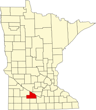
This is a list of the National Register of Historic Places listings in Blue Earth County, Minnesota. It is intended to be a complete list of the properties and districts on the National Register of Historic Places in Blue Earth County, Minnesota, United States. The locations of National Register properties and districts for which the latitude and longitude coordinates are included below, may be seen in an online map.

<span class="mw-page-title-main">National Register of Historic Places listings in Brown County, Minnesota</span>

This is a list of the National Register of Historic Places listings in Brown County, Minnesota. It is intended to be a complete list of the properties and districts on the National Register of Historic Places in Brown County, Minnesota, United States. The locations of National Register properties and districts for which the latitude and longitude coordinates are included below, may be seen in an online map.

<span class="mw-page-title-main">National Register of Historic Places listings in Morrison County, Minnesota</span>

This is a list of the National Register of Historic Places listings in Morrison County, Minnesota. It is intended to be a complete list of the properties and districts on the National Register of Historic Places in Morrison County, Minnesota, United States. The locations of National Register properties and districts for which the latitude and longitude coordinates are included below, may be seen in an online map.

<span class="mw-page-title-main">National Register of Historic Places listings in Otter Tail County, Minnesota</span>

This is a list of the National Register of Historic Places listings in Otter Tail County, Minnesota. It is intended to be a complete list of the properties and districts on the National Register of Historic Places in Otter Tail County, Minnesota, United States. The locations of National Register properties and districts for which the latitude and longitude coordinates are included below, may be seen in an online map.

<span class="mw-page-title-main">National Register of Historic Places listings in Chisago County, Minnesota</span>

This is a list of the National Register of Historic Places listings in Chisago County, Minnesota. It is intended to be a complete list of the properties and districts on the National Register of Historic Places in Chisago County, Minnesota, United States. The locations of National Register properties and districts for which the latitude and longitude coordinates are included below, may be seen in an online map.

<span class="mw-page-title-main">National Register of Historic Places listings in Winona County, Minnesota</span>

This is a list of the National Register of Historic Places listings in Winona County, Minnesota. It is intended to be a complete list of the properties and districts on the National Register of Historic Places in Winona County, Minnesota, United States. The locations of National Register properties and districts for which the latitude and longitude coordinates are included below, may be seen in an online map.

<span class="mw-page-title-main">National Register of Historic Places listings in Itasca County, Minnesota</span>

This is a list of the National Register of Historic Places listings in Itasca County, Minnesota. It is intended to be a complete list of the properties and districts on the National Register of Historic Places in Itasca County, Minnesota, United States. The locations of National Register properties and districts for which the latitude and longitude coordinates are included below, may be seen in an online map.

<span class="mw-page-title-main">National Register of Historic Places listings in Lake County, Minnesota</span>

This is a list of the National Register of Historic Places listings in Lake County, Minnesota. It is intended to be a complete list of the properties and districts on the National Register of Historic Places in Lake County, Minnesota, United States. The locations of National Register properties and districts for which the latitude and longitude coordinates are included below, may be seen in an online map.

<span class="mw-page-title-main">National Register of Historic Places listings in Rock County, Minnesota</span>

This is a list of the National Register of Historic Places listings in Rock County, Minnesota. It is intended to be a complete list of the properties and districts on the National Register of Historic Places in Rock County, Minnesota, United States. The locations of National Register properties and districts for which the latitude and longitude coordinates are included below, may be seen in an online map.

<span class="mw-page-title-main">National Register of Historic Places listings in Clay County, Minnesota</span>

This is a list of the National Register of Historic Places listings in Clay County, Minnesota. It is intended to be a complete list of the properties and districts on the National Register of Historic Places in Clay County, Minnesota, United States. The locations of National Register properties and districts for which the latitude and longitude coordinates are included below, may be seen in an online map.

<span class="mw-page-title-main">National Register of Historic Places listings in Douglas County, Minnesota</span>

This is a list of the National Register of Historic Places listings in Douglas County, Minnesota. It is intended to be a complete list of the properties and districts on the National Register of Historic Places in Douglas County, Minnesota, United States. The locations of National Register properties and districts for which the latitude and longitude coordinates are included below, may be seen in an online map.

<span class="mw-page-title-main">National Register of Historic Places listings in Kandiyohi County, Minnesota</span>

This is a list of the National Register of Historic Places listings in Kandiyohi County, Minnesota. It is intended to be a complete list of the properties and districts on the National Register of Historic Places in Kandiyohi County, Minnesota, United States. The locations of National Register properties and districts for which the latitude and longitude coordinates are included below, may be seen in an online map.

<span class="mw-page-title-main">National Register of Historic Places listings in Lyon County, Minnesota</span>

This is a list of the National Register of Historic Places listings in Lyon County, Minnesota. It is intended to be a complete list of the properties and districts on the National Register of Historic Places in Lyon County, Minnesota, United States. The locations of National Register properties and districts for which the latitude and longitude coordinates are included below, may be seen in an online map.

<span class="mw-page-title-main">National Register of Historic Places listings in Swift County, Minnesota</span>

This is a list of the National Register of Historic Places listings in Swift County, Minnesota. It is intended to be a complete list of the properties and districts on the National Register of Historic Places in Swift County, Minnesota, United States. The locations of National Register properties and districts for which the latitude and longitude coordinates are included below, may be seen in an online map.

<span class="mw-page-title-main">National Register of Historic Places listings in Beltrami County, Minnesota</span>

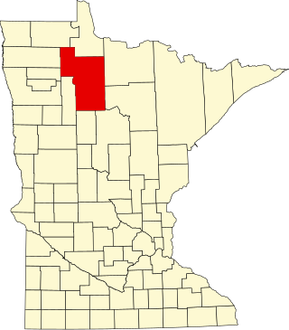
This is a list of the National Register of Historic Places listings in Beltrami County, Minnesota. This is intended to be a complete list of the properties and districts on the National Register of Historic Places in Beltrami County, Minnesota, United States. The locations of National Register properties and districts for which the latitude and longitude coordinates are included below, may be seen in an online map.

<span class="mw-page-title-main">National Register of Historic Places listings in Lac qui Parle County, Minnesota</span>

This is a list of the National Register of Historic Places listings in Lac qui Parle County, Minnesota. It is intended to be a complete list of the properties and districts on the National Register of Historic Places in Lac qui Parle County, Minnesota, United States. The locations of National Register properties and districts for which the latitude and longitude coordinates are included below, may be seen in an online map.

Architects of the National Park Service are the architects and landscape architects who were employed by the National Park Service (NPS) starting in 1918 to design buildings, structures, roads, trails and other features in the United States National Parks. Many of their works are listed on the National Register of Historic Places, and a number have also been designated as National Historic Landmarks.

References

  1. National Park Service, United States Department of the Interior, "National Register of Historic Places: Weekly List Actions", retrieved August 18, 2023.
  2. 1 2 Numbers represent an alphabetical ordering by significant words. Various colorings, defined here, differentiate National Historic Landmarks and historic districts from other NRHP buildings, structures, sites or objects.
  3. The eight-digit number below each date is the number assigned to each location in the National Register Information System database, which can be viewed by clicking the number.
  4. Holum, Liz (December 1984). "National Register of Historic Places Inventory—Nomination Form: Carlton County Courthouse". National Park Service. Retrieved 2016-01-17.
  5. Thomas, Dr. Anthony E. (1983-06-28). "National Register of Historic Places Inventory—Nomination Form: Sts. Joseph and Mary Church". National Park Service. Retrieved 2016-01-17.
  6. Holum, Liz (December 1984). "National Register of Historic Places Inventory—Nomination Form: Cloquet City Hall". National Park Service. Retrieved 2016-01-17.
  7. Holum, Liz (December 1984). "National Register of Historic Places Inventory—Nomination Form: Cloquet-Northern Office Building". National Park Service. Retrieved 2016-01-17.
  8. Mitchell, Diana (1973-03-14). "National Register of Historic Places Inventory – Nomination Form: Grand Portage of the St. Louis River". National Park Service. Retrieved 2016-01-16.
  9. Anderson, Rolf T. (1992-03-29). "National Register of Historic Places Registration Form: Jay Cooke State Park CCC/WPA/Rustic Style Historic District". National Park Service. Retrieved 2016-01-16.
  10. Anderson, Rolf T. (1992-03-29). "National Register of Historic Places Registration Form: Jay Cooke State Park CCC/WPA/Rustic Style Picnic Grounds". National Park Service. Retrieved 2016-01-16.
  11. Anderson, Rolf T. (1992-03-29). "National Register of Historic Places Registration Form: Jay Cooke State Park CCC/WPA/Rustic Style Service Yard". National Park Service. Retrieved 2016-01-16.
  12. Holum, Liz (December 1984). "National Register of Historic Places Inventory—Nomination Form: Lindholm Oil Company Service Station". National Park Service. Retrieved 2016-01-16.
  13. Holum, Liz (December 1984). "National Register of Historic Places Inventory—Nomination Form: Minneapolis St. Paul and Sault Ste. Marie Depot". National Park Service. Retrieved 2016-01-16.
  14. "Moose Lake Area Historical Society" . Retrieved 2012-11-15.
  15. Karppinen, Sandra (August 1984). "National Register of Historic Places Inventory—Nomination Form: Northeastern Hotel". National Park Service. Retrieved 2016-01-16.
  16. Tschofen, Carmen (August 2006). "National Register of Historic Places Registration Form: Oldenburg, Henry C., House". National Park Service. Retrieved 2016-01-16.
  17. Holum, Liz (December 1984). "National Register of Historic Places Inventory—Nomination Form: Park Place Historic District". National Park Service. Retrieved 2016-01-10.
  18. Holum, Liz (December 1984). "National Register of Historic Places Inventory—Nomination Form: Shaw Memorial Library". National Park Service. Retrieved 2016-01-10.
  19. "Carlton County Historical Society" . Retrieved 2012-11-16.
  20. Nord, Mary Ann (2003). The National Register of Historic Places in Minnesota . Minnesota Historical Society. ISBN   0-87351-448-3.
  21. "Changes to the National Register of Historic Places in Minnesota, 2003-2010". Minnesota State Historic Preservation Office. 2011-02-01. Retrieved 2013-03-01.