The Boston Post Road was a system of mail-delivery routes between New York City and Boston, Massachusetts, that evolved into one of the first major highways in the United States.

The Mohawk Trail began as a Native American trade route which connected Atlantic tribes with tribes in Upstate New York and beyond. It followed the Millers River, Deerfield River and crossed the Hoosac Range, in the area that is now northwestern Massachusetts.

Route 146 is a 20.99-mile (33.78 km) north-south expressway in the U.S. state of Massachusetts, maintained by the Massachusetts Department of Transportation (MassDOT). Spanning approximately 21 miles (34 km) along a south–north axis, it is a continuation of Route 146 in Rhode Island, which splits from I-95 in Providence. The southern terminus within Massachusetts exists in Millville, where the expressway enters the state from North Smithfield, Rhode Island. Among several local roads, Route 146 intersects with the Massachusetts Turnpike (I-90) in Millbury and I-290 in Worcester before arriving at its northern terminus at the intersection of several surface streets in downtown Worcester. Most of the route is a freeway, except for a short section near the boundary between Millbury and Sutton where there is driveway access and at-grade crossings.

The National Register of Historic Places is a United States federal official list of places and sites considered worthy of preservation. In the state of Massachusetts, there are over 4,300 listings, representing about 5% of all NRHP listings nationwide and the second-most of any U.S. state, behind only New York. Listings appear in all 14 Massachusetts counties.

The Blackstone Canal was a waterway linking Worcester, Massachusetts, to Providence, Rhode Island through the Blackstone Valley via a series of locks and canals during the early 19th century. Construction was started in 1825, and the canal opened three years later. Following the opening of the Boston and Providence Railroad in 1835, the canal struggled for business. It was ultimately replaced by the Providence and Worcester Railroad, which completed a parallel line in 1847. The canal shut down in 1848. Several segments of the canal are preserved, with the canal alignment and remains listed on the National Register of Historic Places.

Massachusetts Route 32 is a state highway in the U.S. state of Massachusetts. The highway runs 60.66 miles (97.62 km) from the Connecticut state line in Monson, where the highway continues as Connecticut Route 32, north to the New Hampshire state line in Royalston, where the highway continues as New Hampshire Route 32. Route 32 connects several towns on the eastern edge of Western Massachusetts. The highway serves Palmer in eastern Hampden County, Ware in eastern Hampshire County, and Barre and Athol in northwestern Worcester County. Route 32 intersects major east–west routes including U.S. Route 20 and the Massachusetts Turnpike in Palmer, Route 9 in Ware, and US 202 and Route 2 in Athol. The highway has an alternate route, Route 32A, through Hardwick and Petersham.

The 1767 Milestones are historic milestones located along the route of the Upper Boston Post Road between the cities of Boston and Springfield in Massachusetts. The 40 surviving milestones were added to the National Register of Historic Places in 1971. Massachusetts has a total of 129 surviving milestones including those along the upper Post Road. The stones are so named, despite having been placed in many different years, because of a 1767 directive of the Province of Massachusetts Bay that such stones be placed along major roadways. The state highway department was directed in 1960 to undertake their preservation. Many of them underwent a major restoration in 2018.

The Veterans of Foreign Wars Parkway is a historic parkway in Boston, Massachusetts. The southern terminus of the parkway is at Washington Street at the Dedham-West Roxbury border, from where it travels north and then east, ending at a junction with Centre Street, near the Arnold Arboretum. The highway is almost entirely contained within the West Roxbury neighborhood, although it passes through part of the Chestnut Hill neighborhood near its junction with the West Roxbury Parkway. Most of its length, from Spring Street in West Roxbury to its eastern end, is administered by the Massachusetts Department of Conservation and Recreation (DCR), a successor to the Metropolitan District Commission (MDC) which oversaw the road's construction. The parkway was built in stages between 1930 and 1942, and was designed to provide a parkway connection from the Upper Charles River Reservation to other MDC parks via the West Roxbury Parkway. The DCR portion of the road was listed on the National Register of Historic Places in 2005. The road formerly carried the designation for U.S. Route 1.

The Fells Connector Parkways are a group of historic parkways in the cities of Malden and Medford, Massachusetts, suburbs north of the city of Boston. The three parkways, The Fellsway, Fellsway West, and Fellsway East serve to provide access from the lower portion of the Mystic River Reservation to the Middlesex Fells Reservation. The latter two parkways continue northward, providing access to the interior of the Fells and providing a further connection to Lynn Fells Parkway. Significant portions of these parkways south of the Fells, which were among the first connecting parkways designed to be part of the Metropolitan Park System of Greater Boston by Charles Eliot, were listed on the National Register of Historic Places in 2003.

The John Brooks House is an historic house at 12 Nelson Place in Worcester, Massachusetts. Built between 1847 and 1856 by John Brooks, a prominent local farmer and politician, it is one of a small number of 19th-century farmhouses still standing in the city. The house was listed on the National Register of Historic Places in 1980, at which time it was still the hands of Brooks' descendants.

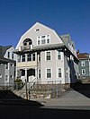
The Ingleside Avenue Historic District is a residential historic district in Worcester, Massachusetts. It consists of a cluster of four triple decker residences and three period garages, all built c. 1928, during the last phase of triple decker construction in the city. All have retained some of their Colonial Revival styling. The district was listed on the National Register of Historic Places in 1990.

The John Johnson Three-Decker is a historic triple decker house in Worcester, Massachusetts. The house was built c. 1894, and is a distinctive variant of the form, with a central projecting bay section. It was listed on the National Register of Historic Places in 1990.

The Massachusetts Avenue Historic District in Worcester, Massachusetts is a 5-acre (2.0 ha) historic district that was listed on the National Register of Historic Places in 1971. At that time, it included 11 contributing buildings and one other contributing site.

This is a list of the National Register of Historic Places listings in Davenport, Iowa. This is intended to be a complete list of the properties and districts on the National Register of Historic Places in Davenport, Iowa, United States. Latitude and longitude coordinates are provided for many National Register properties and districts; these locations may be seen together in an online map.
Boston, Massachusetts is home to many listings on the National Register of Historic Places. This list encompasses those locations that are located south of the Massachusetts Turnpike. See National Register of Historic Places listings in northern Boston for listings north of the Turnpike. Properties and districts located elsewhere in Suffolk County's other three municipalities are also listed separately.
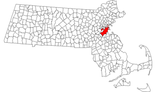
There are 98 properties and historic districts on the National Register of Historic Places in Worcester, Massachusetts, east of I-190 and the north-south section of I-290, which are listed below. Two listings overlap into other parts of Worcester: one of the 1767 Milestones is located in northwestern Worcester, and the Blackstone Canal Historic District traverses all three sections of the city.
There are 112 properties and historic districts on the National Register of Historic Places in Worcester, Massachusetts, west of I-190 and the north–south section of I-290 and north of Massachusetts Route 122, which are listed here. Two listings overlap into other parts of Worcester: one of the 1767 Milestones is located in eastern Worcester, and the Blackstone Canal Historic District traverses all three sections of the city.
There are 291 properties and historic districts on the National Register of Historic Places in Worcester, Massachusetts. Of these, 82 are west of I-190 and the north-south section of I-290 and south of Massachusetts Route 122, and are listed below. One listing, the Blackstone Canal Historic District, overlaps into other parts of the city. Another listing has been removed.

This is a list of the National Register of Historic Places (NRHP) designated in northern Worcester County, Massachusetts. It includes listings from all Worcester County communities through which Massachusetts Route 2 passes, and those that lie to their north. This includes the communities of Ashburnham, Ashby, Athol, Fitchburg, Gardner, Harvard, Lancaster, Leominster, Lunenburg, Phillipston, Royalston, Templeton, Westminster, and Winchendon. National Register listings for other communities in the county are listed elsewhere.

The Lincoln Highway in Greene County, Iowa is a multiple property submission to the National Register of Historic Places, which was approved on March 29, 1993. It includes five individual listings and five historic districts located in Greene County, Iowa, United States. They encompass abandoned sections of dirt roads, paved sections that are now part of other highways, and various sites, objects, structures and pieces of infrastructure that were a part of the Lincoln Highway. The years of historical significance are 1912 to 1928.