This portion of National Register of Historic Places listings in Puerto Rico covers the eastern region of Puerto Rico, from Carolina in the northeast to Arroyo in the southeast. It also includes the islands of Culebra and Vieques.
Names of places given are as appear in the National Register, reflecting name as given in NRHP application at the date of listing. Note, the National Register name system does not accommodate Spanish á, ñ and other letters.
This National Park Service list is complete through NPS recent listings posted August 25, 2023. [1]
[2] | Name on the Register | Image | Date listed [3] | Location | Barrio | Description |
---|---|---|---|---|---|---|
1 | Faro de Punta de las Figuras | October 22, 1981 (#81000687) | Punta de las Figuras, southeast of Arroyo Pueblo 17°57′18″N66°02′52″W / 17.954976°N 66.047657°W | Palmas | Spanish-built Neoclassical lighthouse from 1893, opperated by the U.S. Army during the Second World War. |
[2] | Name on the Register | Image | Date listed [3] | Location | Barrio | Description |
---|---|---|---|---|---|---|
1 | Villarán Bridge | July 19, 1995 (#95000835) | Highway 9959, km 3, spanning Río Canóvanas 18°22′45″N65°53′32″W / 18.379213°N 65.892087°W | Canóvanas Pueblo and Canóvanas | Built in 1892 on the 19th century highway between Río Piedras and Río Grande, this iron and masonry bridge is the best preserved example of an Eiffel pony truss bridge in Puerto Rico or the United States. By 1994, it had been replaced by an adjacent span for vehicular use, but it remained open for pedestrian use. [4] |
[2] | Name on the Register | Image | Date listed [3] | Location | Barrio | Description |
---|---|---|---|---|---|---|
1 | Church San Fernando of Carolina | September 18, 1984 (#84003160) | Muñoz Rivera St., Town Plaza 18°22′52″N65°57′23″W / 18.381072°N 65.956317°W | Carolina Pueblo | Church from 1860 | |
2 | Edificio Alcaldia | December 28, 1983 (#83004197) | Sánchez Osorio St. at José de Diego St. 18°22′53″N65°57′27″W / 18.381253°N 65.957427°W | Carolina Pueblo | From 1927, designed by Rafael Carmoega | |
3 | Quebrada Maracuto | August 27, 2004 (#04000909) | Address restricted [5] | Cacao and Santa Cruz [6] |
[2] | Name on the Register | Image | Date listed [3] | Location | Barrio | Description |
---|---|---|---|---|---|---|
1 | Ceiba Fire Station | February 13, 2013 (#13000012) | 226 Lauro Piñero Avenue 18°15′59″N65°38′52″W / 18.266333°N 65.647698°W | Ceiba Pueblo | Art Deco fire station from 1954, designed and built by the Department Public Works of Puerto Rico. Part of the Fire Stations in Puerto Rico MPS. |
[2] | Name on the Register | Image | Date listed [3] | Location | Barrio | Description |
---|---|---|---|---|---|---|
1 | Faro Isla de Culebritas | October 22, 1981 (#81000686) | Isla Culebrita 18°18′49″N65°13′39″W / 18.313694°N 65.227444°W | Fraile | Spanish-built lighthouse from 1882, it used to aid in the navigation through the Virgin Passage and the Vieques Sound. |
[2] | Name on the Register | Image | Date listed [3] | Location | Barrio | Description |
---|---|---|---|---|---|---|
1 | Church Santiago Apóstol of Fajardo | September 18, 1984 (#84003144) | Town Plaza 18°19′30″N65°39′11″W / 18.324873°N 65.653066°W | Fajardo Pueblo | A church from 1776 | |
2 | Faro de las Cabezas de San Juan | October 22, 1981 (#81000692) | Northeast of Soroco 18°22′53″N65°37′05″W / 18.381457°N 65.618134°W | Cabezas | ||
3 | U.S. Custom House | February 10, 1988 (#88000077) | Union Street 18°20′02″N65°37′50″W / 18.333942°N 65.630564°W | Playa Puerto Real [7] | From 1930, designed by Albert B. Nichols |
[2] | Name on the Register | Image | Date listed [3] | Location | Barrio | Description |
---|---|---|---|---|---|---|
1 | Casa Roig | November 17, 1977 (#77001550) | 66 Antonio López Street 18°08′53″N65°49′30″W / 18.147971°N 65.824867°W | Humacao Pueblo | A Prairie School building from 1920 | |
2 | Church Dulce Nombre de Jesús of Humacao | September 18, 1984 (#84003140) | Town Plaza 18°09′01″N65°49′34″W / 18.150157°N 65.826199°W | Humacao Pueblo | Late Gothic Revival church from 1869 | |
3 | Guzmán Family Pantheon | April 17, 1995 (#95000436) | Junction of Padre Rivera and Miguel Casillas Streets 18°09′08″N65°49′40″W / 18.152327°N 65.827904°W | Humacao Pueblo | Eclectic style pantheon from 1864 | |
4 | Humacao Customs House | May 18, 1995 (#95000599) | Junction of Marina and Aduana Streets 18°09′54″N65°44′38″W / 18.164909°N 65.743989°W | Punta Santiago | Spanish Colonial building from 1872, designed by Julian Cruellas y Rovira | |
5 | Humacao District Courthouse | May 18, 1995 (#95000596) | Junction of Dr. Vidal and Antonio López Streets 18°08′58″N65°49′27″W / 18.149531°N 65.824152°W | Humacao Pueblo | Classical Revival style courthouse from 1925, the Casa Alcaldía de Humacao | |
6 | Palmira López de Pereyó House | April 14, 1995 (#95000435) | Junction of Font Martelo and Minerva Streets 18°09′02″N65°49′20″W / 18.150545°N 65.822218°W | Humacao Pueblo | Prairie School house from 1930 designed by Francisco Valines Cofresi | |
7 | Antonia Sáez School | May 18, 1995 (#95000597) | Junction of Font Martelo and Isidro Ortiz Sreets 18°09′06″N65°49′49″W / 18.151750°N 65.830288°W | Humacao Pueblo | A Mission/Spanish Revival school from 1922 |
[2] | Name on the Register | Image | Date listed [3] | Location | Barrio | Description |
---|---|---|---|---|---|---|
1 | Cueva del Indio | September 4, 2003 (#03000884) | Approximately 1.2 km (0.75 mi) north of Highway 198 18°11′50″N65°52′24″W / 18.1972°N 65.8733°W | Quebrada Arenas | Site of a former ceremonial ball court (batey) and containing examples of indigenous rock art. Part of the Prehistoric Rock Art of Puerto Rico MPS. |
[2] | Name on the Register | Image | Date listed [3] | Location | Barrio | Description |
---|---|---|---|---|---|---|
1 | Roberto Clemente Walker Crash Site | August 31, 2022 (#100008070) | PR 187 km. 6, Punta Maldonado and 1.5 nautical mi. offshore in the Atlantic Ocean 18°27′45″N65°57′30″W / 18.4625°N 65.958333°W | Loíza vicinity | Site where plane carrying baseball player Roberto Clemente crashed. | |
2 | Cueva de Los Indios | June 24, 1982 (#82003823) | Address restricted [5] | Torrecilla Baja | ||
3 | Parroquia del Espiritu Santo y San Patricio [lower-alpha 1] | September 8, 1976 (#76002251) | Plaza de Loíza 18°26′00″N65°52′47″W / 18.433238°N 65.879610°W | Loíza Pueblo | Dates from 1729 [8] |
[2] | Name on the Register | Image | Date listed [3] | Location | Barrio | Description |
---|---|---|---|---|---|---|
1 | Williams Products Corporation | November 14, 2012 (#12000938) | Highway 992, km 0.3 18°22′16″N65°43′07″W / 18.370986°N 65.718615°W | Mata de Plátano | Historic factory building from 1957 designed in the Modernist style. Also known as La Williams Factory. |
[2] | Name on the Register | Image | Date listed [3] | Location | Barrio | Description |
---|---|---|---|---|---|---|
1 | Casa Alcaldia de Maunabo | August 23, 2022 (#100008050) | Calle Santiago Iglesias #8 18°00′25″N65°53′59″W / 18.006922°N 65.899667°W | Maunabo Pueblo | Historic city hall building from the early 20th century. | |
2 | Faro de Punta de la Tuna | October 22, 1981 (#81000688) | Southeast of Puerto Maunabo 17°59′18″N65°53′07″W / 17.988370°N 65.885274°W | Emajagua | Historic Neoclassical lighthouse from 1892. Part of the Lighthouse System of Puerto Rico TR. |
[2] | Name on the Register | Image | Date listed [3] | Location | Barrio | Description |
---|---|---|---|---|---|---|
1 | Bridge No. 122 | July 19, 1995 (#95000836) | Highway 3, km 9, spanning the Santiago River 18°11′18″N65°43′30″W / 18.188386°N 65.725108°W | Río and Húcares | ||
2 | Church Nuestra Señora del Rosario of Naguabo | December 10, 1984 (#84000456) | Town Plaza 18°12′43″N65°44′09″W / 18.212062°N 65.735754°W | Naguabo Pueblo | 1856 Spanish Colonial style building designed by Mariano Bosch | |
3 | Icacos Petroglyph Group | December 1, 2015 (#15000855) | Address restricted [5] | Address restricted [5] | ||
4 | Villa Del Mar | June 23, 1983 (#83002293) | Highway 3, km 66.2 18°11′21″N65°42′54″W / 18.189168°N 65.714985°W | Húcares | 1917 building also known as "El Castillo" |
[2] | Name on the Register | Image | Date listed [3] | Location | Barrio | Description |
---|---|---|---|---|---|---|
1 | María Dávila Semidey School | November 14, 2012 (#12000939) | 300 Muñoz Rivera Street 18°00′21″N66°01′01″W / 18.005906°N 66.017068°W | Patillas Pueblo | Mission Revival-style school building from 1925. |
[2] | Name on the Register | Image | Date listed [3] | Location | Barrio | Description |
---|---|---|---|---|---|---|
1 | Baño de Oro | January 21, 2020 (#100004891) | Highway 191, km 12.1 Coordinates missing | Mameyes II | ||
2 | Baño Grande | February 28, 2017 (#100000685) | Highway 191, km 11.85 18°18′06″N65°47′07″W / 18.301616°N 65.785388°W | Mameyes II | ||
3 | Río Grande Fire Station | January 29, 2013 (#12001248) | 6 Juan R. González Street 18°22′46″N65°49′49″W / 18.379540°N 65.830289°W | Río Grande Pueblo |
[2] | Name on the Register | Image | Date listed [3] | Location | Barrio | Description |
---|---|---|---|---|---|---|
1 | Rafael Acevedo House | March 17, 1994 (#94000249) | Víctor Duteil Street between San José and Baldorioty Streets 18°09′00″N65°26′35″W / 18.149938°N 65.443051°W | Isabel Segunda | House built in Vieques Creole / Neoclasico style in 1900 | |
2 | Algodones 2 (12VPr2-204) | August 21, 1991 (#91001037) | Address restricted [5] | Puerto Diablo | A village site, an archeological site | |
3 | Algodones 3 (12VPr2-205) | August 21, 1991 (#91001038) | Address restricted [5] | Puerto Diablo | Another village site, an archeological site | |
4 | Algodones 6 (12VPr2-229) | August 21, 1991 (#91001032) | Address restricted [5] | Puerto Diablo | Another village site, an archeological site | |
5 | Camp Garcia (Campo Asilo) 3 (12VPr2-164) | August 21, 1991 (#91001041) | Address restricted [5] | Puerto Ferro | Site of petroglyphs | |
6 | Casa Alcaldía de Vieques | March 17, 1994 (#94000174) | Junction of Carlos LeBrun and Benítez Guzmán Streets 18°08′59″N65°26′30″W / 18.149654°N 65.441606°W | Isabel Segunda | Town hall, from 1850 | |
7 | Casa Augusto Delerme | February 2, 1994 (#93001555) | 7 Benítez Guzmán Street 18°09′00″N65°26′31″W / 18.150084°N 65.441849°W | Isabel Segunda | A "4-Room Creole House", from 1850 | |
8 | Casa Delerme-Anduze No. 2 | November 22, 1993 (#93001205) | 355 Antonio Mellado Street 18°08′55″N65°26′29″W / 18.148710°N 65.441300°W | Isabel Segunda | A "six-room Creole house" from 1876 | |
9 | Casa de Jaime Puig Lemoine | April 14, 1994 (#94000363) | 161 65 de Infantería Street 18°08′55″N65°26′35″W / 18.148680°N 65.442993°W | Isabel Segunda | Bungalow/Craftsman house from 1930, designed by Jaime Puig | |
10 | Central Playa Grande | September 10, 1992 (#92001236) | Address restricted [5] | Llave | A site with architecture by Matias Hjardemaal and others | |
11 | Delerme-Anduze House | February 2, 1994 (#93001556) | 361 Antonio Mellado Street 18°08′55″N65°26′29″W / 18.148601°N 65.441414°W | Isabel Segunda | A Creole gallery house | |
12 | Faro de Vieques | November 17, 1977 (#77001551) | Punta Mulas 18°09′16″N65°26′38″W / 18.1545°N 65.4438°W | Puerto Diablo | Lighthouse built in 1896 | |
13 | Fuerte de Vieques | November 18, 1977 (#77001552) | Calle del Fuerte 18°08′51″N65°26′21″W / 18.147436°N 65.439070°W | Isabel Segunda | Fort built in 1845 which now houses the Vieques Museum of Art and History | |
14 | Hacienda Casa del Francés | November 18, 1977 (#77001548) | Near Esperanza 18°06′09″N65°28′15″W / 18.102381°N 65.470786°W | Puerto Real | Plantation architecture from 1910. Destroyed by fire in 2005. [10] | |
15 | Laguna Jalova Archeological District | September 10, 1992 (#92001237) | Address restricted [5] | Puerto Diablo | Also known as "Western Friendly Front Line" | |
16 | Llave 13 (12VPr2-175) | August 21, 1991 (#91001036) | Address restricted [5] | Llave | ||
17 | Loma Jalova 3 (12VPr2-219) | August 21, 1991 (#91001034) | Address restricted [5] | Puerto Diablo | ||
18 | Monte Largo 2 (12VPr2-172) | August 21, 1991 (#91001042) | Address restricted [5] | Puerto Diablo | ||
19 | Paramayon 2 | September 10, 1992 (#92001241) | Address restricted [5] | Llave | ||
20 | Le Pistolet (12VPr2-168) | August 22, 1991 (#91001040) | Address restricted [5] | Punta Arenas | ||
21 | Playa Grande 9 (12VPr2-212) | August 21, 1991 (#91001035) | Address restricted [5] | Llave | ||
22 | Playa Vieja | September 10, 1992 (#92001235) | Address restricted [5] | Punta Arenas | ||
23 | Punta Jalova | September 10, 1992 (#92001239) | Address restricted [5] | Puerto Diablo | ||
24 | Resolucion Historic District [lower-alpha 2] | September 10, 1992 (#92001242) | Address restricted [5] | Punta Arenas | Work designed by T. J. J. M. Le Guillou and others [11] | |
25 | Smaine–Ortiz House | February 2, 1994 (#93001554) | 341 Antonio Mellado Street 18°08′49″N65°26′29″W / 18.146970°N 65.441358°W | Isabel Segunda | ||
26 | Las Tumbas de J. J. María le Guillou | August 26, 1994 (#94000923) | Highway 200, near Isabel Segunda 18°09′10″N65°25′57″W / 18.152750°N 65.432444°W | Puerto Diablo | Classical Revival style, from 1843 | |
27 | Ventana Archeological District | September 10, 1992 (#92001238) | Address restricted [5] | Llave | ||
28 | Ventana 4 (12VPr2-171) | August 21, 1991 (#91001039) | Address restricted [5] | Punta Arenas | ||
29 | Vieques Pharmacy | March 2, 1994 (#94000061) | Junction of Carlos LeBrun and Víctor Duteil Streets 18°08′58″N65°26′30″W / 18.149341°N 65.441751°W | Isabel Segunda | ||
30 | Yanuel 8 (12VPr2-173) | August 21, 1991 (#91001043) | Address restricted [5] | Puerto Diablo | ||
31 | Yanuel 9 (12VPr2-220) | August 21, 1991 (#91001033) | Address restricted [5] | Puerto Diablo |
[2] | Name on the Register | Image | Date listed [3] | Location | Barrio | Description |
---|---|---|---|---|---|---|
1 | Yabucoa Fire Station | February 13, 2013 (#13000015) | 22 Luis Muñoz Rivera Street 18°03′07″N65°52′38″W / 18.051979°N 65.877330°W | Yabucoa Pueblo | Historic Art Deco fire station from 1943. Also known as the Parque de Bombas de Yabucoa. |
Teófilo José Jaime María Le Guillou was the founder of the municipality of Vieques, Puerto Rico.
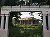
Castillo Serrallés is a mansion located in the city of Ponce, Puerto Rico, overlooking the downtown area. It was built during the 1930s for Juan Eugenio Serrallés, son of businessman Juan Serrallés, founder of Destilería Serrallés. The structure sits on a 2.5-acre (1.0 ha) exceedingly manicured property. Nowadays, the structure functions as a museum, Museo Castillo Serrallés, with information about the sugar cane and rum industries and its impact in the economy of Puerto Rico. It is also increasingly used as a venue for social activities, including destination weddings. The property was listed in the National Register of Historic Places in 1980. In 1996, the structure was featured in the American TV series America's Castles.
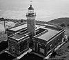
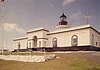
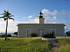
Guánica Light was a historic lighthouse located in the municipality of Guánica, Puerto Rico in the Guánica State Forest. It was first lit in 1893 and deactivated in 1950. The light marked the entrance to Guánica Bay and bridge the gap between Los Morrillos Light and Caja de Muertos Light.
The López Residence is a historic house in Aguadilla, Puerto Rico. Built in 1914, this one-story, Neoclassical structure is architecturally significant as a typical urban residence for a well-to-do Puerto Rican family in the early 20th century, and as one of the most important remaining works by architect Manuel Gómez Tejera. Notable architectural elements of the house include its five slender, octagonal Corinthian columns, recessed ceiling panels on the balcony, ornate cast-iron balcony ornamentation, native ceramic tile floors, rooftop balcony, four louvered wooden doors with scrollwork frames facing the street, and filigreed interior arches supported by turned and octagonal columns. It faces the 1925 District Courthouse across Progreso Street, forming a historic Neoclassical set.
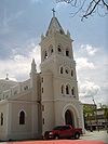
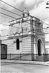
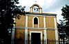
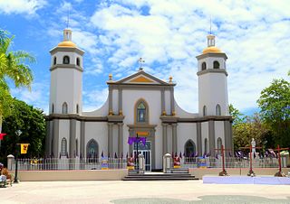
The Parroquia del Espíritu Santo y San Patricio, constructed in 1645, is one of Puerto Rico's oldest Catholic parish churches. It is located in the main plaza of the municipality of Loíza, Puerto Rico. The church represents an ethnically distinct community characterized by a rich Afro-Hispanic cultural and folk craft tradition. The structure's massive walls and buttresses helped the building withstand flood and hurricanes and likewise provided the people of Loíza with shelter from such natural disasters. The church, named after Saint Patrick, was enlarged to its present size in 1729.
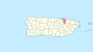
Quebrada Maracuto, in the municipality of Carolina, Puerto Rico, is a prehistoric rock art site. It was listed on the National Register of Historic Places in 2004.
The Hacienda Casa del Francés, near Esperanza on the island of Vieques, Puerto Rico, also known as Sportsmen's House, was a plantation house built in 1910. It was listed on the National Register of Historic Places in 1977.
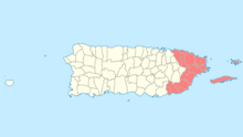
This portion of National Register of Historic Places listings in Puerto Rico is along the north coast, north plains, and north slopes of the Cordillera, from Isabela to Guaynabo.
This is a list of properties and districts in the southern municipalities of Puerto Rico that are listed on the National Register of Historic Places. It includes places along the southern coast of the island, and on the south slope of Puerto Rico's Cordillera Central.
The Gómez Residence is a historic house in Mayagüez, Puerto Rico. It was designed by architect Francisco Porrata-Doría in a Mission/Spanish Revival, neo-Andalusí style, and was built in 1933.
The Iglesia San Ramón Nonato, in some sources also referred to as Iglesia San Juan Bautista y San Ramón Nonato, is a Roman Catholic parish church in the town plaza of Juana Díaz, Puerto Rico.
Hacienda Buena Unión in the municipality of San Germán, Puerto Rico was built in 1870. It is also known as Trapiche del Guamá or Hacienda Acosta.
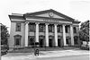
The Edificio José de Diego in Mayagüez, Puerto Rico, also known as the Rectoría, is a historic building on the grounds of the University of Puerto Rico at Mayagüez. It was built in 1913. It was listed on the National Register of Historic Places in 1977.
This is a list of properties and districts in the western municipalities of Puerto Rico that are listed on the National Register of Historic Places. It includes places along the western coast, and on islands, and on the western slope of Puerto Rico's Cordillera Central.
This portion of National Register of Historic Places listings in Puerto Rico is along the central mountain region, from Las Marías and Maricao in the central-west to Juncos in the central-east, including the slopes of the Cordillera.
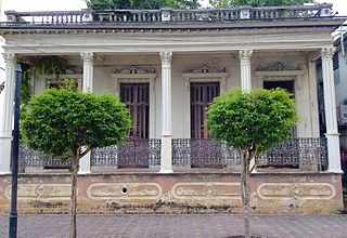
Casa Font-Ubides, also known as the Residencia Monsanto is a historic building located on the north side of Castillo Street in Ponce, Puerto Rico, in the city's historic district. The building dates from 1913. It was designed by the architect Blas Silva. The architecture consists of 19th Classical revival and Art Nouveau architectural styles. The building is of architectural significance for its aggressive incorporation of curvilinear forms and ornaments. The complete preservation of the original architecture of the Monsanto Residence, its unique design amongst the houses of Ponce, and its location within the historic urban core of the city qualify it as one of a series of grand houses and an integral part of the character of Ponce.
The Casa de los Ponce de León is a historic house in San Germán, Puerto Rico. It is possibly the oldest residence in use in Puerto Rico. Its most famous resident was the poet Lola Rodriguez Ponce de León.
This portion of National Register of Historic Places listings in Puerto Rico covers the municipality of San Juan.
Ball court/plaza sites of Puerto Rico and the U.S. Virgin Islands are the subject of a multiple property submission to the National Register of Historic Places (NRHP) in the U.S. territories of Puerto Rico and the Virgin Islands. The submission consists of 56 archaeological sites containing bateyes, out of which five have been inscribed in the NRHP.