The International Telecommunication Union is a specialized agency of the United Nations responsible for many matters related to information and communication technologies. It was established on 17 May 1865 as the International Telegraph Union, making it the oldest UN agency.

The American Community Survey (ACS) is a demographics survey program conducted by the U.S. Census Bureau. It regularly gathers information previously contained only in the long form of the decennial census, such as ancestry, citizenship, educational attainment, income, language proficiency, migration, disability, employment, and housing characteristics. These data are used by many public-sector, private-sector, and not-for-profit stakeholders to allocate funding, track shifting demographics, plan for emergencies, and learn about local communities. Sent to approximately 295,000 addresses monthly, it is the largest household survey that the Census Bureau administers.

The Organization of the Black Sea Economic Cooperation (BSEC) is a regional international organization focusing on multilateral political and economic initiatives aimed at fostering cooperation, peace, stability and prosperity in the Black Sea region. It traces its origin to 25 June 1992, when Turkish President Turgut Özal and leaders of ten other countries gathered in Istanbul and signed the Summit Declaration and the "Bosphorus Statement". BSEC Headquarters – the Permanent International Secretariat of the Organization of the Black Sea Economic Cooperation – was established in March 1994, also in Istanbul.
The American Association of Motor Vehicle Administrators (AAMVA) is a non-governmental, voluntary, tax-exempt, nonprofit educational association. AAMVA is a private corporation which strives to develop model programs in motor vehicle administration, police traffic services, and highway safety.

A convention, in the sense of a meeting, is a gathering of individuals who meet at an arranged place and time in order to discuss or engage in some common interest. The most common conventions are based upon industry, profession, and fandom. Trade conventions typically focus on a particular industry or industry segment, and feature keynote speakers, vendor displays, and other information and activities of interest to the event organizers and attendees. Professional conventions focus on issues of concern along with advancements related to the profession. Such conventions are generally organized by societies or communities dedicated to promotion of the topic of interest. Fan conventions usually feature displays, shows, and sales based on pop culture and guest celebrities. Science fiction conventions traditionally partake of the nature of both professional conventions and fan conventions, with the balance varying from one to another. Conventions also exist for various hobbies, such as gaming or model railroads.

The United States National Grid (USNG) is a multi-purpose location system of grid references used in the United States. It provides a nationally consistent "language of location", optimized for local applications, in a compact, user friendly format. It is similar in design to the national grid reference systems used in other countries. The USNG was adopted as a national standard by the Federal Geographic Data Committee (FGDC) of the US Government in 2001.
The National Conference of State Legislatures (NCSL), established in 1975, is a "nonpartisan public officials’ association composed of sitting state legislators" from the states, territories and commonwealths of the United States.
Participatory GIS (PGIS) or public participation geographic information system (PPGIS) is a participatory approach to spatial planning and spatial information and communications management.
Geospatial metadata is a type of metadata applicable to geographic data and information. Such objects may be stored in a geographic information system (GIS) or may simply be documents, data-sets, images or other objects, services, or related items that exist in some other native environment but whose features may be appropriate to describe in a (geographic) metadata catalog.

The United Nations Conference on International Organization (UNCIO), commonly known as the San Francisco Conference, was a convention of delegates from 50 Allied nations that took place from 25 April 1945 to 26 June 1945 in San Francisco, California, United States. At this convention, the delegates reviewed and rewrote the Dumbarton Oaks agreements of the previous year. The convention resulted in the creation of the United Nations Charter, which was opened for signature on 26 June, the last day of the conference. The conference was held at various locations, primarily the War Memorial Opera House, with the Charter being signed on 26 June at the Herbst Theatre in the Veterans Building, part of the Civic Center. A square adjacent to the Civic Center, called "UN Plaza", commemorates the conference.

The Association for Slavic, East European, and Eurasian Studies (ASEEES) is a scholarly society dedicated to the advancement of knowledge about the former Soviet Union and Eastern and Central Europe. The ASEEES supports teaching, research, and publication relating to the peoples and territories within this area.
The African Energy Commission (AFREC) is a specialized agency of the African Union (AU), under the Commission for Infrastructure and Energy, in charge of coordinating, harmonizing, protecting, conserving, developing, rational exploitation, commercializing and integrating energy resources on the African continent.
The Summit of South American-Arab Countries is a bi-regional mechanism for cooperation and political coordination, which gathers the 22 member-States of the League of Arab States and the 12 countries of South America. Better known by its Portuguese and Spanish acronym ASPA, the bi-regional forum was created upon proposal of the Brazilian President Luiz Inácio Lula da Silva, during the I ASPA Summit of Heads of State and Government, held in Brasilia, Brazil, in May 2005. Since its inception, a second ASPA Summit happened in Doha, Qatar, in March 2009, and a third Summit was held in Lima, Peru, in October 2012, after being postponed, from February 2011, due to the Arab Spring uprisings.

The World Database on Protected Areas (WDPA) is the largest assembly of data on the world's terrestrial and marine protected areas, containing more than 260,000 protected areas as of August 2020, with records covering 245 countries and territories throughout the world. The WDPA is a joint venture between the United Nations Environment Programme World Conservation Monitoring Centre and the International Union for Conservation of Nature World Commission on Protected Areas.

The Arctic policy of the United States is the foreign policy of the United States in regard to the Arctic region. In addition, the United States' domestic policy toward Alaska is part of its Arctic policy.
The Stephenson Disaster Management Institute at Louisiana State University is located in the Stephenson National Center for Security Research and Training at LSU.
The Urban and Regional Information Systems Association (URISA) is a non-profit association of professionals using geographic information systems (GIS) and other information technologies to solve challenges at all levels of government. URISA promotes the effective and ethical use of spatial information and technology for the understanding and management of urban and regional systems.
Statistics Botswana (StatsBots) is the National statistical bureau of Botswana. The organization was previously under the Ministry of Finance and development planning as a department and was called Central Statistics Office. The organisation was initially set up in 1967 through an Act of Parliament – the Statistics Act and thereafter transformed into a parastatal through the revised Statistics Act of 2009. This act gives the Statistics Botswana the mandate and authority to collect, process, compile, analyse, publish, disseminate and archive official national statistics. It is also responsible for "coordinating, monitoring and supervising the National Statistical System" in Botswana. The office has its main offices in Gaborone and three satellite offices in Maun, Francistown and Ghanzi. The different areas in statistics that should be collected are covered under this Act and are clearly specified. The other statistics that are not specified can be collected as long as they are required by the Government, stakeholders and the users.
The Western Association of Map Libraries (WAML) is a not-for-profit organization dedicated to the promotion, preservation, and use of maps and geospatial information. Its purpose as stated in its by-laws is:
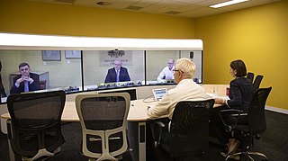
National Cabinet is the Australian intergovernmental decision-making forum composed of the prime minister and state and territory premiers and chief ministers. Originally established on 13 March 2020 in response to the COVID-19 pandemic, National Cabinet replaced the now-defunct Council of Australian Governments (COAG) as the primary intergovernmental forum on 29 May 2020, citing excessive bureaucracy and infrequent meetings. National Cabinet is composed of the main forum, and specialised committees focusing on: rural and regional Australia, skills, infrastructure, health, transport, population and migration, and energy.
