Related Research Articles
The United Nations Convention on the Law of the Sea (UNCLOS), also called the Law of the Sea Convention or the Law of the Sea Treaty, is an international agreement that establishes a legal framework for all marine and maritime activities. As of May 2023, 168 countries and the European Union are parties.

Borders are usually defined as geographical boundaries, imposed either by features such as oceans and terrain, or by political entities such as governments, sovereign states, federated states, and other subnational entities. Political borders can be established through warfare, colonization, or mutual agreements between the political entities that reside in those areas.

Territorial waters are informally an area of water where a sovereign state has jurisdiction, including internal waters, the territorial sea, the contiguous zone, the exclusive economic zone, and potentially the extended continental shelf. In a narrower sense, the term is often used as a synonym for the territorial sea.

Law of the sea is a body of international law governing the rights and duties of states in maritime environments. It concerns matters such as navigational rights, sea mineral claims, and coastal waters jurisdiction.

An exclusive economic zone (EEZ), as prescribed by the 1982 United Nations Convention on the Law of the Sea, is an area of the sea in which a sovereign state has exclusive rights regarding the exploration and use of marine resources, including energy production from water and wind.
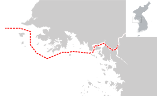
The Northern Limit Line or North Limit Line (NLL) – 북방한계선 – is a disputed maritime demarcation line in the Yellow (West) Sea between the Democratic People's Republic of Korea (DPRK) in the north, and the Republic of Korea (ROK) in the south. This line of military control acts as the de facto maritime boundary between North and South Korea.

The Malaysia–Thailand border divides the sovereign states of Malaysia and Thailand and consists of a land boundary running for 595 km across the Malay Peninsula and maritime boundaries in the Straits of Malacca and the Gulf of Thailand/South China Sea. The Golok River forms the easternmost 95 km stretch of the land border.

Perú v. Chile was a public international law case concerning a territorial dispute between the South American republics of Peru and Chile over the sovereignty of an area at sea in the Pacific Ocean approximately 37,900 square kilometres (14,600 sq mi) in size. Peru contended that its maritime boundary delimitation with Chile was not fixed, but Chile claimed that it holds no outstanding border issues with Peru. On January 16, 2008, Peru brought forth the case to the International Court of Justice at The Hague, the Netherlands, which accepted the case and formally filed it as the Case concerning maritime delimitation between the Republic of Peru and the Republic of Chile - Perú v. Chile.
The United States has land borders with only Canada and Mexico, both of them long. Its has maritime boundaries with many countries due to its extensive exclusive economic zone (EEZ). All of its maritime borders with Canada are at least partially disputed, and its territorial claims on three Caribbean islands are disputed.
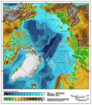
The Arctic consists of land, internal waters, territorial seas, exclusive economic zones (EEZs) and international waters above the Arctic Circle. All land, internal waters, territorial seas and EEZs in the Arctic are under the jurisdiction of one of the eight Arctic coastal states: Canada, Denmark, Finland, Iceland, Norway, Russia, Sweden and the United States. International law regulates this area as with other portions of Earth.
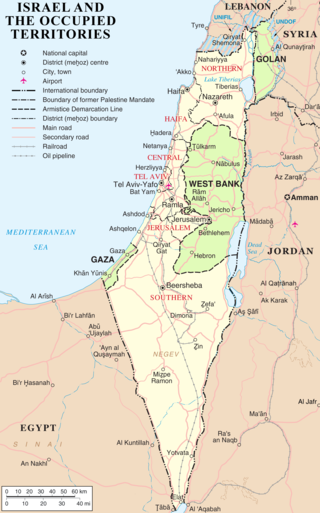
The modern borders of Israel exist as the result both of past wars and of diplomatic agreements between the State of Israel and its neighbours, as well as an effect of the agreements among colonial powers ruling in the region before Israel's creation. Only two of Israel's five total potential land borders are internationally recognized and uncontested, while the other three remain disputed; the majority of its border disputes are rooted in territorial changes that came about as a result of the 1967 Arab–Israeli War, which saw Israel occupy large swathes of territory from its rivals. Israel's two formally recognized and confirmed borders exist with Egypt and Jordan since the 1979 Egypt–Israel peace treaty and the 1994 Israel–Jordan peace treaty, while its borders with Syria, Lebanon and the Palestinian territories remain internationally defined as contested.
Malaysia and Vietnam are two Southeast Asian countries with maritime boundaries which meet in the Gulf of Thailand and South China Sea. The two countries have overlapping claims over the continental shelf in the Gulf of Thailand. Both countries have, however, come to an agreement to jointly exploit the natural resources in the disputed area pending resolution of the dispute over sovereignty.

The Australia–Indonesia border is a maritime boundary running west from the two countries' tripoint maritime boundary with Papua New Guinea in the western entrance to the Torres Straits, through the Arafura Sea and Timor Sea, and terminating in the Indian Ocean. The boundary is, however, broken by the Timor Gap, where Australian and East Timorese territorial waters meet and where the two countries have overlapping claims to the seabed.
A maritime boundary is a conceptual division of Earth's water surface areas using physiographical or geopolitical criteria. As such, it usually bounds areas of exclusive national rights over mineral and biological resources, encompassing maritime features, limits and zones. Generally, a maritime boundary is delineated at a particular distance from a jurisdiction's coastline. Although in some countries the term maritime boundary represents borders of a maritime nation that are recognized by the United Nations Convention on the Law of the Sea, maritime borders usually serve to identify the edge of international waters.
The equidistance principle, or principle of equidistance, is a legal concept in maritime boundary claims that a nation's maritime boundaries should conform to a median line that is equidistant from the shores of neighboring nations. The concept was developed in the process of settling disputes in which the borders of adjacent nations were located on a contiguous continental shelf:
An equidistance line is one for which every point on the line is equidistant from the nearest points on the baselines being used. The equidistance principle is a methodology that has been endorsed by the United Nations Convention on the Law of the Sea but predates that treaty and has been used by the Supreme Court of the United States, states, and nations to establish boundaries equitably.
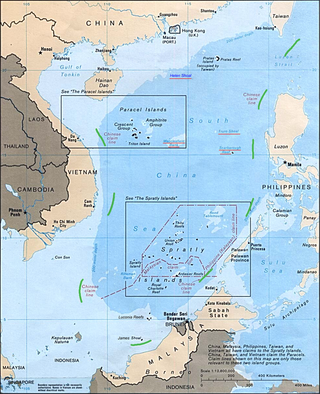
The nine-dash line, also referred to as the eleven-dash line by Taiwan, is a set of line segments on various maps that accompanied the claims of the People's Republic of China and the Republic of China in the South China Sea. The contested area includes the Paracel Islands, the Spratly Islands, the Pratas Island and the Vereker Banks, the Macclesfield Bank, and the Scarborough Shoal. Certain places have undergone land reclamation by the PRC, ROC, and Vietnam. The People's Daily of the PRC uses the term Duànxùxiàn (断续线) or Nánhǎi Duànxùxiàn, while the ROC government uses the term Shíyīduàn xiàn.
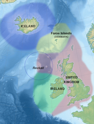
Several states have claimed interests over the sea bed adjoining Rockall, an uninhabitable granite islet which is located within the exclusive economic zone (EEZ) of the United Kingdom. Ireland, Denmark, Iceland, and the United Kingdom have all made submissions to the commission set up under the United Nations Convention on the Law of the Sea (UNCLOS).

The border between Indonesia and the Philippines consists of a maritime boundary mainly on the Celebes Sea that separates the two Southeast Asian countries as defined through a pact that was signed by both parties in 2014. The border is also the Exclusive Economic Zone (EEZ) boundary between Indonesia and the Philippines, which is delimited through eight geographic coordinate points. It has a length of 1,162.2 kilometres dividing across the Celebes Sea to the Philippine Sea.
The borders of Indonesia include land and maritime borders with Malaysia, Papua New Guinea, and East Timor, as well as shared maritime boundaries with Australia, India, Palau, Philippines, Singapore, Thailand, and Vietnam.
References
- ↑ G.J. Tanja, Ministry of Foreign Affairs, The Netherlands, comment in I.F. Dekker, H.H.G. Post, and T.M.C. Asser, The Gulf War of 1980-1988: The Iran-Iraq War in International Legal Perspective, Martinus Nijhoff Publishers (1992), pp.44-45.
- ↑ Zou Keyuan (1999). "Maritime Boundary Delimitation in the Gulf of Tonkin" (PDF). Ocean Development & International Law. The South China Sea. Archived from the original (PDF) on Feb 15, 2010.
- ↑ "Maritime Space: Maritime Zones and Maritime Delimitation". UN. Retrieved Nov 15, 2009.
- ↑ "Boundary Delimitation & Malapportionment: Practice & Solutions | International IDEA". www.idea.int. Retrieved 2024-05-16.