The Naval Oceanographic Office (NAVOCEANO), located at John C. Stennis Space Center in south Mississippi, is an echelon IV component of the Naval Meteorology and Oceanography Command (NMOC) and comprises approximately 1,000 civilian, military and contract personnel responsible for providing oceanographic products and services to all elements within the Department of Defense.
The Royal Navy created the post of Hydrographer of the Navy in 1795, which within five years was producing naval charts for naval and merchant use. In 1830, the U.S. Navy established the Depot of Charts and Instruments maintain a supply of navigational instruments and nautical charts for issue to naval vessels. It soon became apparent that the Depot would be unable to obtain and maintain an adequate supply of the latest data unless it undertook production of charts from its own surveys. In 1837, the first survey sponsored by the Depot and led by Lieutenant Charles Wilkes resulted in four engraved charts published for use by the U.S. Navy.
Lieutenant Wilkes continued his surveying and gained fame as leader of the U.S. Exploring Expedition. The expedition ranged over the eastern Atlantic to Antarctica, the coasts of both Americas, and far into the west and southwest Pacific. It began the U.S. collection of world magnetic data and contributed substantially to hydrographic, meteorological, botanical and geological knowledge of the explored regions.
During the succeeding five years, 87 similar charts were published and issued from the results of surveys by Wilkes and his officers. These individual surveys, however, were limited in scope; the Depot needed a way to gather information quickly on a worldwide basis. Naval officer Matthew Fontaine Maury, who became known as "The Pathfinder of the Seas", supplied the answer to this dilemma.
Commander Maury, who held the position of Hydrographer of the Navy from 1842 to 1861, is credited with founding the science of oceanography.[citation needed] His system for collecting and using oceanographic data revolutionized navigation of the seas. Maury assumed command of the Navy's Depot of Charts and Instruments in 1842. Possessing an active, scientific mind, he immediately recognized possibilities for expanding the services of the Depot. Following the example of the Royal Navy's Hydrographer of the Navy, he suggested that, if all U.S. shipmasters would submit reports of their experiences to a central agency, the data could be digested, compiled and published for the benefit of all.
Within five years, 26 million reports poured into the Depot, which originally had been intended only as a storehouse of charts and instruments. In 1854, the agency was given the official name of The U.S. Naval Observatory and Hydrographical Office. In 1866, an Act of Congress separated the two functions, establishing the Hydrographic Office as a distinct activity. By this time the Office's mission had expanded to include "the carrying out of surveys, the collection of information and the printing of every kind of nautical chart or publication." The Office continued to grow throughout the nineteenth century.
By the turn of the century, pleasure cruises had become a popular form of vacationing, and suddenly the attention of the world was drawn to a new danger to navigation – ice. The collision of the Titanic with an iceberg in 1912 prompted the Hydrographic Office to urge that an ice patrol be established to document sea-ice hazards to prevent such disasters. This was the beginning of today's sophisticated, high-tech methods of surveying, measuring and recording ice thickness, ice-ridge profiles and other characteristics to monitor ocean-ice conditions above and below the surface.
Because features and conditions of the world's oceans are constantly changing, surveying, charting and mapping must be continuous processes. Experiences during World War I showed the need for greater accuracy for oceanographic data. By 1922, responding to these needs, the Navy had developed the first practical sonic sounding machine, making it possible to surpass all previous efforts in deep-sea sounding and bathymetric charting. Aerial photography was used for the first time that year.
Following the attack on Pearl Harbor, the demands for charts increased to about 40 times the normal pre-war rate. The Hydrographic Office was moved to more adequate facilities at Suitland, Maryland, about 6 miles (10km) from the nation's Capitol building, and was placed under the cognizance of the Chief of Naval Operations to focus activities directly to programs of national security. Additional survey vessels were obtained, each equipped to conduct surveys and to produce printed charts aboard ship in a minimum of time to keep up with fleet advances across the Pacific. At the peak of World War II, 43 million charts were printed and issued in one year.
The Hydrographic Office was redesignated U.S. Naval Oceanographic Office (NAVOCEANO) in 1962, and in 1976 the Office was relocated to the National Space Technology Laboratory (NSTL), which is now known as the John C. Stennis Space Center, in south Mississippi.[1]
NAVOCEANO is the largest subordinate command under the Commander, Naval Meteorology and Oceanography Command, which is also located at Stennis Space Center.
Ships
NAVOCEANO's seven oceanographic ships are operated by the Military Sealift Command. The oceanographic survey ships have no homeport and are forward-deployed, surveying the ocean 365 days every year. To avoid interrupting continuous operations, oceanographers from NAVOCEANO relieve their fellow surveyors by flying to locations around the world to meet the ship.
The T-AGS 60 class ships were designed and constructed to provide multipurpose oceanographic capabilities in coastal and deep-ocean areas for NAVOCEANO.
On board, surveyors are equipped to conduct physical, chemical and biological oceanographic operations; multidisciplinary environmental investigations; ocean engineering and marine acoustics; marine geology and geophysics; and bathymetric, gravimetric and magnetometric surveying.
Typical missions of the 329-foot-long (100m) T-AGS 60 vessels may include oceanographic sampling and data collection of surface water, mid-water and ocean floor parameters; the launch and recovery of small boats known as hydrographic survey launches (HSLs); the launching, recovering and towing of scientific packages (both tethered and autonomous) including the handling, monitoring and servicing of remotely operated vehicles (ROVs); shipboard oceanographic data processing and sample analysis; and precise navigation, trackline maneuvering and station-keeping to support deep-ocean and coastal surveys.
T-AGS 50 Class
NAVOCEANO formerly operated two coastal hydrographic T-AGS 50 class ship, John McDonnell(T-AGS-51), and Littlehales(T-AGS-52). At a length of 208 feet, both ships were slightly smaller than the T-AGS 60 class ships. Both were capable of collecting hydrographic data on all headings in seas with wave heights up to 9 feet and could launch and recover two HSLs and other survey equipment in seas up to 4 feet. McDonnell was decommissioned on 25 August 2010.[3]Littlehales was transferred to the National Oceanic and Atmospheric Administration (NOAA) on 3 March 2003. She was commissioned into the NOAA Atlantic Fleet as NOAAS Thomas Jefferson (S 222) on 8 July 2003.
A hydrographic office is an organization which is devoted to acquiring and publishing hydrographic information.
Matthew Fontaine Maury was an American oceanographer and naval officer, serving the United States and then joining the Confederacy during the American Civil War.
The United Kingdom Hydrographic Office (UKHO) is the UK's agency for providing hydrographic and marine geospatial data to mariners and maritime organisations across the world. The UKHO is a trading fund of the Ministry of Defence (MoD) and is located in Taunton, Somerset, with a workforce of approximately 900 staff.
USS Maury (AGS-16) was a hydrographic surveying ship in service with the United States Navy from 1945 to 1969.
The Pathfinder-class survey ships are owned by the United States Navy and operated by Military Sealift Command for the Naval Oceanographic Office ("NAVOCEANO"). They have mostly civilian crews, including scientists from NAVOCEANO.
USNS Pathfinder is a United States Navy oceanographic survey ship, and the lead vessel of her class. Her mission is to collect acoustical, biological, physical, and geophysical surveys of the world's oceans. This data has many uses, but a primary focus is characterizing the ocean environment in order to improve the U.S. Navy's undersea warfare capabilities.
USNS Bowditch (T-AGS-21) was the lead ship of her class of oceanographic survey ships for the United States Navy. Launched as the SS South Bend Victory in 1945, Maritime Commission hull number MCV 694, a type VC2-S-AP3 Victory ship, she was named for Nathaniel Bowditch, the second U.S. Navy vessel named in his honor. The ship was acquired by the Navy in August 1957 and converted to an AGS at Charleston Naval Shipyard. Named Bowditch on 8 August 1957 and placed in service 8 October 1958 for operation by the Military Sea Transportation Service (MSTS).
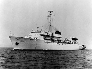
NOAAS Thomas Jefferson is a National Oceanic and Atmospheric Administration (NOAA) hydrographic survey vessel in service since 2003. The ship was built for the United States Navy as USNS Littlehales (T-AGS-52) serving as one of two new coastal hydrographic survey vessels from 1992 until transfer to NOAA in 2003 when it was named after Founding Father and third U.S. president, Thomas Jefferson.
George Washington Littlehales was an American oceanographer and civil engineer, known for his work with the Hydrographic Office.
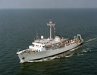
USNS Wyman (T-AGS-34) was an oceanographic survey vessel laid down on 18 July 1968 by the Defoe Shipbuilding Company of Bay City, Michigan. Launched on 30 October 1969, sponsored by Mrs. Francis J. Blouin, wife of the Deputy Chief of Naval Operations, Vice Admiral Francis J. Blouin; she was accepted by the Military Sealift Command (MSC) on 19 November 1971 at the Boston Naval Shipyard.
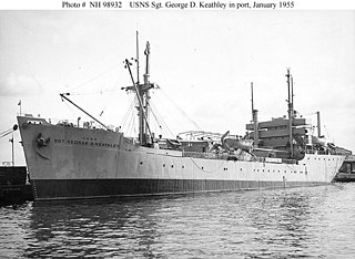
USNS Sgt. George D. Keathley, was a World War II United States cargo vessel that was used for troop transport and later converted to a survey vessel. She was laid down and launched as MS Alexander R. Nininger, Jr., then renamed MS Acorn Knot. She was put into US Army service as USAT Acorn Knot, then renamed USAT Sgt. George D. Keathley. She was transferred to the US Navy and became USNS Sgt. George D. Keathley (T-APC-117), but was later re-designated T-AGS-35. She was leased to the Republic of China, where she served as Chu Hwa (AGS-564). Both Nininger and Keathley were posthumous Medal of Honor recipients.
The Naval Meteorology and Oceanography Command (COMNAVMETOCCOM) or CNMOC, serves as the operational arm of the Naval Oceanography Program. Headquartered at the Stennis Space Center in Mississippi, CNMOC is an echelon three command reporting to United States Fleet Forces Command (USFLTFORCOM). CNMOC's clemency is globally distributed, with assets on larger ships, shore facilities at fleet concentration areas, and larger production centers in the US.
USNS Silas Bent (T-AGS-26) was a Silas Bent class survey ship acquired by the United States Navy in 1964 and delivered to the Military Sealift Command in 1965. Silas Bent spent her career in the Pacific Ocean performing oceanographic surveys. The ship was equipped with the Oceanographic Data Acquisition System (ODAS) as were the later oceanographic survey ships USNS Kane(T-AGS-27) and USNS Wilkes(T-AGS-33).
The Silas Bent class is frequently found applied to four ships though the Naval Vessel Register and some sources officially break them into the subclasses of AGS-26 and AGS-33. Silas Bent was the first of the first four purpose built ships for U.S. Navy surveys. Previous ships had been modifications of various naval types.
USNS Marie Tharp (T-AGS-66) is a Pathfinder-class oceanographic survey ship operated by the Military Sealift Command of the United States Navy. The seventh ship in her class, Marie Tharp is named for oceanographer Marie Tharp; the ship was renamed in 2023 from Maury.
USNS John McDonnell (T-AGS-51) was a hydrographic survey ship operated by the Military Sealift Command (MSC) with a contract crew for the Naval Oceanographic Office which assigned a military and civilian hydrographic detachment to conduct coastal surveys. The ship and its sister, USNS Littlehales (T-AGS-52), were replacements for the coastal hydrographic survey vessels USNS Chauvenet(T-AGS-29) and USNS Harkness(T-AGS-32).
USNS Kane (T-AGS-27) was a Silas Bent-class survey ship acquired by the United States Navy and delivered to Military Sealift Command in 1967. Kane spent her career performing oceanographic surveys. The ship was equipped with the Oceanographic Data Acquisition System (ODAS) as were oceanographic survey ships USNS Silas Bent(T-AGS-26) and USNS Wilkes(T-AGS-33).
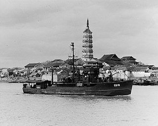
USS John Blish was a Patrol Craft Sweeper (PCS) of the PCS-1376-Class, five of which were converted to small hydrographic survey vessels designated AGS and later coastal survey vessels, AGSc, that conducted hydrographic surveys for the United States Navy during and immediately after the Second World War. The small PCS type vessels assigned to the United States Navy Hydrographic Office missions conducted pre invasion surveys, sometimes under fire, with the survey crews erecting signals for survey and later navigation, laying buoys and placing lights.
The Russian Hydrographic Service, full current official name Department of Navigation and Oceanography of the Ministry of Defence of the Russian Federation, is Russia's hydrographic office, with responsibility to facilitate navigation, performing hydrographic surveys and publishing nautical charts.
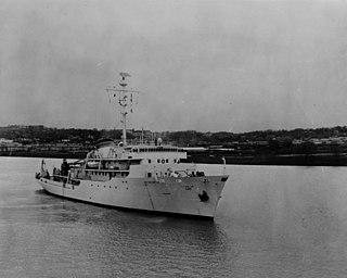
USNS Chauvenet (T-AGS-29) was a multi-function survey ship laid down on 24 May 1967, at Upper Clyde Shipbuilding Corp., Glasgow, Scotland. The ship was the second survey ship, Chauvenet(AGS-11) being the first, named for William Chauvenet (1820-1870). He was instrumental in the founding of the United States Naval Academy at Annapolis, MD. The mathematics department of the US Naval Academy in Annapolis was founded by Chauvenet and is housed in Chauvenet Hall. Chauvenet was launched on 13 May 1968, delivered to the US Navy, 13 November 1970 and placed in service with the Military Sealift Command (MSC) as USNS Chauvenet (T-AGS-29). The ship conducted coastal hydrographic and topographic surveys under the technical direction of the Oceanographer of the Navy through the U.S. Naval Oceanographic Office (NAVOCEANO). The ship was assigned to the Pacific for surveys, sister ship Harkness(T-AGS-32) was assigned Atlantic duties, doing so until inactivated in November 1992.
This page is based on this Wikipedia article Text is available under the CC BY-SA 4.0 license; additional terms may apply. Images, videos and audio are available under their respective licenses.