
The neighborhoods of Albany, New York are listed below.
The neighborhoods of Albany, New York are listed below.

Arbor Hill [1] is an historic neighborhood in northeastern Albany near the Hudson River. Arbor Hill encompasses the area from Clinton Avenue (formerly called Patroon Street) north to the Livingston Avenue Railroad Bridge (where North Albany begins) and from the Hudson River west to Henry Johnson Boulevard. [2] Arbor Hill was outside Albany's first boundaries as set up in the Dongan Charter of 1686. The original name of the area was Colonie. Incorporated as a village on April 9, 1804, Arbor Hill was annexed by the city in 1815, at which time Patroon Street became Clinton Avenue. [3] The name "Arbor Hill" comes from the nickname of the Ten Broeck Mansion, an important cultural and historical destination in the neighborhood. Arbor Hill includes Dudley Heights, a residential neighborhood north of Livingston Avenue that was the first location of the Dudley Observatory. [4] Demographically, Arbor Hill is predominantly African-American. [5]
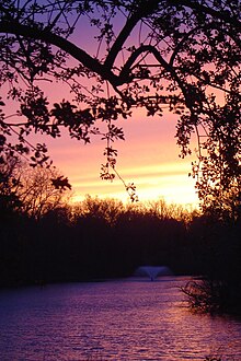
The Buckingham Lake neighborhood is bordered by Western Avenue on the north, Route 85 on the west, Krumkill Road and New Scotland Avenues on the south, and South Manning Boulevard on the east. [6] [7]

Center Square [8] [9] contains many buildings of architectural significance and is locally famous for its nightlife, entertainment, culture, and dining. Center Square includes the area bounded by Lark Street on the west, Spring Street on the north, South Swan Street on the east and Jay Street on the south, as well as the upper portion of Lancaster Street between Lark Street and Willett Street. It is included in its entirety within the Center Square/Hudson–Park Historic District. Center Square is also notable for its close proximity to Washington Park. Center Square and the Hudson/Park neighborhood to the south are often compared to New York City's Greenwich Village for their eclectic mix of residential and commercial uses, including bars, night clubs, restaurants, and unique stores. Albany's gay culture is vibrant in this area. [10]
Eagle Hill [9] is a residential neighborhood in western Albany near the Town of Guilderland that is named for the Eagle Hill Cemetery. Eagle Hill is a large neighborhood "bounded by the [W. Averell Harriman State Office Building Campus] to the north, parts of Krumkill Road and the State Thruway (Interstate 87) to the south, an assortment of streets to the west (including Arch Avenue, North Bridge Drive and Wood Street), and Route 85 and the Buckingham Lake neighborhood to the east." Eagle Hill is an ethnically diverse community that has been described as "a tranquil, pretty place with narrow, tree-lined streets and small city lots with a mix of housing styles." [11]
While Manning Boulevard runs for several miles from the north side of Albany to the south side of the city, the Manning Boulevard neighborhood "encompasses the area on both sides of Manning Boulevard between Washington and Western Avenues." [9] [12] This small neighborhood is unusual in the City of Albany because of the carriage paths that run on either side of this stretch of Manning Boulevard. According to the Manning Boulevard Neighborhood Association, these carriage paths were created in the late nineteenth century. [12]
Melrose is a neighborhood east of the State Office Campus which features mostly one-family homes and includes Rosemont Park. Located in western Albany, Melrose is roughly bounded by Washington Avenue to the north, Western Avenue to the south, Brevator Street to the west, and Manning Boulevard to the east. Melrose Avenue itself is built on the right-of-way of the first passenger railroad in the state of New York, which ran from Albany to Schenectady. The historic Jesse Buel House is located in Melrose. Melrose has been described as "a cute family neighborhood with some history" and "a quiet, pretty place with older houses in a wide assortment of styles." [13]
The Normanskill neighborhood draws its name from the Normans Kill, a creek that forms part of Albany's southern boundary. Normanskill includes the former Hamlets of Hurstville and Karlsfeld, which were annexed from the Town of Bethlehem in 1967. [14]
North Albany was settled in the mid-17th century by the Patroon of Rensselaerswyck and his tenants and later became a hamlet in the town of Watervliet. North Albany is located roughly between the Town of Colonie, New York and Village of Menands, New York to the north, the Livingston Avenue railroad bridge to the south, [15] the Hudson River to the east, and Van Rensselaer Boulevard to the west.
Tucked between University Heights and the southern edge of Washington Park, the small neighborhood of Park South underwent urban renewal efforts in the early 21st century, with existing housing units being removed or renovated and new office, commercial, and apartment buildings being added. [16]

The Pine Hills neighborhood [17] is roughly bounded by Washington Avenue to the north, South Lake Avenue to the east, Woodlawn Avenue and Cortland Street to the south, and South Manning Boulevard to the west. Pine Hills received its name from the Albany Land Improvement Company in 1891. [18] The neighborhood consists mainly of freestanding multi-unit, duplex, and semi-detached houses and is home to Albany High School, the LaSalle School, the College of St. Rose, and the Alumni Quad of the University at Albany. The area of Pine Hills east of Main Avenue and north of Myrtle Avenue is commonly referred to as the "student ghetto" due to its predominant population of college students, many from Long Island or New York City. [19]

A large and diverse area of Albany, the South End [20] consists of several smaller neighborhoods. Neighborhoods within the South End include the following:
Delaware Avenue is a main entrance to the city from the south, specifically the Bethlehem/Delmar area. The Delaware Avenue neighborhood [9] is located southwest of the Empire State Plaza. Delaware Avenue is the western border of the South End. Only a small part of Delaware Avenue is considered the "Delaware Neighborhood". In recent years, Federal stimulus money was invested into the neighborhood to build new streets, lighting, trees, and contribute to safety. [21]

The Mansion neighborhood is dominated by the Governor's Mansion for which it is named. In the Mansion neighborhood, [22] all major 19th-century architectural styles are represented. Italianate is the most widely represented style in the district, and it is present in many levels of sophistication. A number of buildings use elements of both the Greek Revival and Italianate styles, but there are also some highly refined examples of these individual styles. There are also some unusual examples of the application of Gothic Revival decoration to rowhouse construction.[ citation needed ]
The Dunes is a neighborhood located in the long, narrow western protrusion of Albany known as the Pine Bush, west of Crossgates Mall. According to the City of Albany website, "the neighborhood has a distinctly suburban feel." [9]

The Rapp Road Community Historic District is a 14-acre (5.7 ha) residential area that was listed on the National Register of Historic Places in 2002. The District is a rare intact example of a chain migration community from the Great Migration—the movement of 6 million African-Americans out of the rural Southern United States to the urban Northeast, Midwest, and West that occurred between 1916 and 1970. [23] [24] [25]
The Rapp Road Community Historic District lies along Rapp Road between Pine Lane and the South Frontage Road of Washington Avenue Extension. The District lies just north of the boundary between the City of Albany and the Town of Guilderland. [26]

University Heights is home to the Albany College of Pharmacy, Albany Law School, Sage College of Albany, and Albany Medical College, which is part of the Albany Medical Center. [27]
West Hill [28] stretches from Central Avenue north to Tivoli Hollow, and from Henry Johnson Boulevard west to Manning Boulevard. [29] A low-income neighborhood, [30] [31] [32] [33] West Hill is dominated by Central Avenue, which is Albany's "Main Street" and an important thoroughfare into Albany, and by Clinton and Livingston Avenues. West Hill is a primarily African-American neighborhood. [34]

East Greenbush is a town in Rensselaer County, New York, United States. It is a suburb of Albany. The population was 16,473 at the 2010 census. The word Greenbush is derived from the Dutch het groen bosch, referring to the pine woods that originally covered the land. The first settlement of the land now known as East Greenbush was made by tenants under patroon Kiliaen van Rensselaer circa 1630. The town was established in 1855 as Clinton, and was renamed in 1858. It is mostly suburban along its major highways and rural in the southwestern and northeastern corners.

Hancock Park is a neighborhood in the Wilshire area of Los Angeles, California. Developed in the 1920s, the neighborhood features architecturally distinctive residences, many of which were constructed in the early 20th century. Hancock Park is covered by a Historic Preservation Overlay Zone (HPOZ).

Larchmont is a half-square-mile neighborhood in the central region of the City of Los Angeles, California. It has three schools and one small park. It has been the site of early and recent motion picture shoots.

Melrose Hill is a neighborhood in Los Angeles. A portion of the neighborhood is designated as a Historic Preservation Overlay Zone.

New York State Route 443 (NY 443) is an east–west state highway in the Capital District of New York in the United States. The route begins at an intersection with NY 30 in the town of Schoharie and ends 33.44 miles (53.82 km) later at a junction with U.S. Route 9W (US 9W) and US 20 in the city of Albany. It ascends the Helderberg Escarpment in the towns of Berne and New Scotland. Within the town of Bethlehem and the city of Albany, NY 443 is known as Delaware Avenue.

Mid-City West is an area in the western part of Central Los Angeles that is served by the Mid City West Neighborhood Council. It contains the neighborhoods of Beverly–Fairfax, Beverly Grove, Burton Way, Carthay Circle, Melrose, Miracle Mile and Park La Brea.

Lark Street is a historic street in Albany, New York, US. It is part of the Arbor Hill, Sheridan Hollow, Center Square, Park South and Hudson/Park neighborhoods, and is located one block east of Washington Park. Lark Street is the site of many independently owned shops, coffee houses, restaurants, art galleries, antique shops, marketing agencies, bars and tattoo shops. Although the part between Madison Avenue and Washington Avenue was rebuilt in 2002-2003 to place new roadways, trees and sidewalks in front of the new shops in the active portion of Lark Street, some local residents have protested against the neglect of the northern end of the street, which runs down into the less-affluent Arbor Hill neighborhood. Lark Street and Jay Street was used as a location during the filming of Ironweed. The Washington Avenue Armory is located at the corner of Lark Street and Washington Avenue.

The Clinton Avenue Historic District in Albany, New York, United States, is a 70-acre (28 ha) area along that street between North Pearl and Quail streets. It also includes some blocks along neighboring streets such as Lark and Lexington.

The Rapp Road Community Historic District is located in the Pine Bush area of Albany, New York. It is a 14-acre (5.7 ha) residential neighborhood. In 2002 it was listed on the National Register of Historic Places.
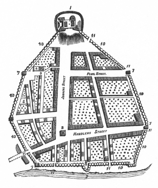
The streets of Albany, New York have had a long history going back almost 400 years. Many of the streets have changed names over the course of time, some have changed names many times. Some streets no longer exist, others have changed course. Some roads existed only on paper. The oldest streets were haphazardly laid out with no overall plan until Simeon De Witt's 1794 street grid plan. The plan had two grids, one west of Eagle Street and the old stockade, and another for the Pastures District south of the old stockade.

Arbor Hill is a neighborhood in Albany, New York, generally defined as the area from Clinton Avenue north to Tivoli Hollow and the Livingston Avenue Railroad Bridge and from Broadway west to Henry Johnson Boulevard. Both Clinton Avenue and Henry Johnson Boulevard are signed as U.S. Route 9. It was outside Albany's first boundaries as set up in the Dongan Charter of 1686. The original name of the area was Colonie, and the area was incorporated under that name as a village in 1804; it was annexed by Albany in 1815. There are two sub-neighborhoods in Arbor Hill, Dudley Heights and the Ten Broeck Triangle. "Arbor Hill" was the name given to the Ten Broeck estate; the Ten Broeck Mansion is still an important cultural and historical museum. The neighborhood has other historical and cultural sights such as the Palace Theatre and St. Joseph's Church. Demographically it is predominantly African-American.

The Bergen Section of Jersey City, New Jersey is the neighborhood on either side of Kennedy Boulevard between Saint Peter's College/ McGinley Square and Communipaw Avenue in the Bergen-Lafayette section of the city. The name Bergen, used throughout Hudson County, is taken from the original Bergen, New Netherland settlement at Bergen Square.
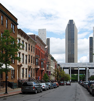
The architecture of Albany, New York, embraces a variety of architectural styles ranging from the early 18th century to the present. The city's roots date from the early 17th century and few buildings survive from that era or from the 18th and early 19th century. The completion of the Erie Canal in 1825 triggered a building boom, which continued until the Great Depression and the suburbanization of the area afterward. This accounts for much of the construction in the city's urban core along the Hudson River. Since then most construction has been largely residential, as the city spread out to its current boundaries, although there have been some large government building complexes in the modernist style, such as Empire State Plaza, which includes the Erastus Corning Tower, the tallest building in New York outside of New York City.
Pine Hills is a neighborhood in Albany, New York, generally defined as the area from Manning Boulevard to the west, Woodlawn Avenue to the south, Lake Avenue to the east, and Washington Avenue to the north. The neighborhood consists mainly of freestanding multi-unit, duplex, and semi-detached houses and is home to Albany High School, the LaSalle school, the College of St. Rose, and the Alumni Quad of the University at Albany. Though mostly residential due to historical reasons from its founding, Pine Hills is home to two neighborhood commercial districts ; Middle Madison, from Partridge to Quail streets was designated first, and then a latter designated district, Upper Madison, from Main Avenue to North Allen Street. The area of Pine Hills east of Main Avenue and north of Myrtle Avenue is commonly referred to as the student ghetto due to its predominant population of college-age students. The area of Pine Hills west of Main Avenue features many large Queen Anne, Folk Victorian, and Colonial Revival homes. Upper Madison, where it meets Western Avenue near St. Rose is the center of a commercial area, complete with a movie theater, grocery store, fast food strip mall, retail, restaurants, a library, community playhouse, police station, pharmacy, and elementary school.

Sheridan Hollow is a neighborhood in Albany, New York located in a ravine north of Downtown Albany. Capitol Hill to the south and Arbor Hill to the north flank the ravine. Often the neighborhood is overlooked by city residents, and outsiders who work in the neighborhood often don't recognize the name of the neighborhood. This is due to the identity of the Hollow being subsumed into its larger neighbor Arbor Hill, for instance news stories of events are often accredited to the wrong neighborhood. Being on undesirable land for development in colonial times, growth was slow in the Hollow and the neighborhood was populated through the centuries by a series of ethnic groups new to Albany, such as the Irish, Polish, and African Americans.
The Arbor Hill Historic District–Ten Broeck Triangle, originally the Ten Broeck Historic District, is a seven-block area located within the Arbor Hill neighborhood north of what is today downtown Albany, New York, United States. In 1979 its easternmost third, the Ten Broeck Triangle, the second oldest residential neighborhood in the city, was recognized as a historic district and listed on the National Register of Historic Places. Four years later, the district was increased to its current size and renamed to reflect its expansion to include some of the rest of Arbor Hill.
The Center Square/Hudson–Park Historic District is located between Empire State Plaza and Washington Park in Albany, New York, United States. It is a 27-block, 99-acre (40 ha) area taking in both the Center Square and Hudson/Park neighborhoods, and Lark Street on the west. In 1980 it was recognized as a historic district and listed on the National Register of Historic Places.
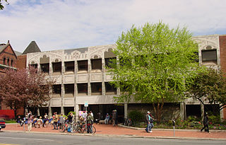
Albany Public Library (APL) is a public library system serving the city of Albany, New York. APL also operates as the Central Library for the Upper Hudson Library System, a resource sharing consortium which unites public library services across twenty-nine member libraries in Albany County and Rensselaer County. Governed by a publicly elected board of trustees, APL is a school district public library with a budget largely funded by a tax levy presented annually to registered voters in the City School District of Albany. The library has seven branches located in various neighborhoods of Albany, New York. The branches are circulating libraries that are open to the general public. The library was developed in the 19th century, founded from society libraries and the wealth of private citizens, and currently holds a collection of 250,000 items.
gazetteer of new york.