Nettlebed

Last updated

Nettlebed
Nettle bed kiln (small).JPG
Pottery kiln, possibly 17th-century
Oxfordshire UK location map.svg
Red pog.svg
Nettlebed
Location within Oxfordshire
Area6.13 km2 (2.37 sq mi)
Population727 (2011 Census)
  Density 119/km2 (310/sq mi)
OS grid reference SU7086
Civil parish
  • Nettlebed
District
Shire county
Region
Country England
Sovereign state United Kingdom
Post town Henley-on-Thames
Postcode district RG9
Dialling code 01491
Police Thames Valley
Fire Oxfordshire
Ambulance South Central
UK Parliament
Website Nettlebed Community
List of places
UK
England
Oxfordshire
51°34′41″N0°59′24″W / 51.578°N 0.990°W / 51.578; -0.990
Nettlebed smock mill (postcard, circa 1910) Nettlebed Mill.jpg
Nettlebed smock mill (postcard, circa 1910)

Nettlebed is a village and civil parish in Oxfordshire in the Chiltern Hills about 4+12 miles (7 km) northwest of Henley-on-Thames and 6 miles (10 km) southeast of Wallingford. The parish includes the hamlet of Crocker End, about 12 mile (800 m) east of the village. The 2011 Census recorded a parish population of 727. [1]

Contents

Archaeology

It is claimed that in the 17th century a "Palæolithic floor" was found in Nettlebed Common. [2] Mesolithic flint microliths and cores have been found in the parish. [3]

History

The earliest known records of the name "Nettlebed" are from the 13th century. The Inquisitiones post mortem record it as Netelbedde in 1252 and 1276. The name does mean a nettlebed: a place overgrown with nettles. [4] Nettlebed village is on an ancient route through the Chiltern Hills between Henley-on-Thames and Wallingford, which for centuries was part of a trunk route between London and Oxford. The road between Henley and Wallingford was made into a turnpike in 1736 and ceased to be a turnpike in 1873. [5] It is now classified as the A4130. Nettlebed's strategic position led to its having several pubs, inns and coaching inns. They included the White Hart, which is 17th-century, [6] and the Bull Inn [7] and Sun Inn, [8] which are 18th-century. Only the White Hart in the High Street is still trading. [9] [10]

Nettlebed had a sub-post office and general store in Watlington Street. It has now ceased trading and is a private house. In 2012 Thierry Kelaart and Patrick Heathcote-Amory, son of Sir Ian Heathcote-Amory were married at St Bartholomew's parish church. Michael Middleton acted as father of the bride and guests included the Duchess of Cambridge. [11] The Old Priest House, on the High Street, is a Grade II listed building. [12]

Parish church

The Church of England parish of Saint Bartholomew was originally a chapelry of the adjacent parish of Benson. There is a record of the Empress Matilda giving the benefice of Benson, including chapels at Nettlebed and Warborough, to the Augustinian Abbey at nearby Dorchester, Oxfordshire in about 1140. [13] The Medieval church building was replaced in 1845–46 by the present Gothic Revival brick building, designed by a member of the Hakewill family of architects. [14] The only surviving part of the previous church is the lower stages of the brick west tower, which seems to be 18th-century. [15]

The church has some 20th-century stained glass windows, including two made in 1970 by John Piper and Patrick Reyntiens. One is the chancel east window, in which a central tree of life is flanked by fish on one side and butterflies on the other. [16] The other is the baptistery south window in the south aisle. This shows a tree of life with birds perching in it including an owl, a hawk and a pheasant. [17] The tower has a ring of six bells, all cast by Charles and George Mears of the Whitechapel Bell Foundry in 1846. [18]

Joyce Grove

The Scottish banker Robert Fleming bought Joyce Grove in 1903, along with its 2,000-acre (810 ha) estate. A new house was commissioned from the architect C.E. Mallows in 1908. After Robert Fleming's death in 1938 the house and its grounds were given to St Mary's Hospital, London. Joyce Grove was used as a convalescent home during the war, and more recently became a Sue Ryder Care Home. [19]

Pottery

Bricks, tiles and pottery were made in Nettlebed from the second half of the 14th century [20] [21] until the 1930s.[ citation needed ] In the 15th century Nettlebed supplied ceramic tiles to Abingdon Abbey [20] and bricks to Stonor House. [22] The name "Crocker End" means "Potter's End". One remaining brick "bottle kiln" is preserved in Nuffield. It may be 17th-century. It is a Grade II* listed building. [23] In 1674, George Ravenscroft obtained from Nettlebed, the sand used in the making of the first flint glass.[ citation needed ]

Windmill

Nettlebed had what seems to have been the only smock mill in Oxfordshire. [24] It used to be at Chinnor but was moved to a windier site at Nettlebed in about 1825. It was a slender octagonal building with four common sails and a fantail. It burned down in 1912. [25]

Amenities

Nettlebed Folk Club

The village has a long-established and highly regarded folk club which holds concerts on Monday evenings from 8pm at The Village Club in Nettlebed High Street. The Folk Song Club is a volunteer run, non-profit organisation. It was founded in July 1975 at the Bull Inn. When Brakspear Brewery closed the Bull Inn in 1991, the club moved to its present venue, which has capacity for 200 people. [26] Many notable singers and musicians have performed at the club. They include Martin Carthy, Fairport Convention, John Kirkpatrick, Ralph McTell, Show of Hands, Steeleye Span and Richard Thompson. [26] The Club is also known for special performances such as its "Feast of Fiddles'" where a mix of leading national performers and local artists provide themed evenings. In 2002 the club won the BBC Radio 2 Folk Club of the Year Award. [27]

Transport

Thames Travel bus route X38 links Nuffield with Wallingford and Oxford in one direction and Henley on Thames and Reading, Berkshire in the other. It stops on the A4130 main road at Nettlebed Green, near the brick kiln at the east end of the village. Buses run generally hourly from Mondays to Saturdays. There is no Sunday service. [28]

Notable residents

See also

Related Research Articles

<span class="mw-page-title-main">Oxfordshire</span> County of England

Oxfordshire is a ceremonial county in South East England. The county is bordered by Northamptonshire and Warwickshire to the north, Buckinghamshire to the east, Berkshire to the south, and Wiltshire and Gloucestershire to the west. The city of Oxford is the largest settlement and county town.

<span class="mw-page-title-main">Henley-on-Thames</span> Town in Oxfordshire, England

Henley-on-Thames is a town and civil parish on the River Thames in Oxfordshire, England, 9 miles (14 km) northeast of Reading, 7 miles (11 km) west of Maidenhead, 23 miles (37 km) southeast of Oxford and 37 miles (60 km) west of London, near the tripoint of Oxfordshire, Berkshire and Buckinghamshire. The population at the 2021 Census was 12,186.

<span class="mw-page-title-main">Harwell, Oxfordshire</span> Human settlement in England

Harwell is a village and civil parish in the Vale of White Horse about 2 miles (3 km) west of Didcot, 6 miles (10 km) east of Wantage and 13 miles (21 km) south of Oxford. The parish measures about 3.5 miles (6 km) north – south, and almost 2 miles (3 km) east – west at its widest point. In 1923 its area was 2,521 acres (1,020 ha). Historically in Berkshire, it has been administered as part of Oxfordshire, England, since the 1974 boundary changes. The parish includes part of Harwell Science and Innovation Campus in the southwest. The 2011 census recorded the parish's population as 2,349.

<span class="mw-page-title-main">Hurley, Berkshire</span> Village and civil parish in England

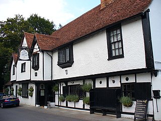
Hurley is a village and rural civil parish in Berkshire, England. Its riverside is agricultural, except for Hurley Priory, as are the outskirts of the village. The Olde Bell Inn adjoining the priory is believed to date from 1135.

<span class="mw-page-title-main">Streatley, Berkshire</span> Thames-side village, Berkshire, England

Streatley is a village and civil parish on the River Thames in Berkshire, England. The village faces Goring-on-Thames. The two places share in their shops, services, leisure, sports and much of their transport. Across the river is Goring & Streatley railway station and the village cluster adjoins a lock and weir. The west of the village is a mixture of agriculture and woodland plus a golf course. The village has a riverside hotel. Much of Streatley is at steeply varying elevations, ranging from 51m AOD to 185m at Streatley Warren, a hilltop point on its western border forming the eastern end of the Berkshire Downs. This Area of Outstanding Natural Beauty is topped by the 87-mile The Ridgeway path, which crosses the Thames at Goring and Streatley Bridge.

<span class="mw-page-title-main">Culham</span> Human settlement in England

Culham is a village and civil parish in a bend of the River Thames, 1 mile (1.6 km) south of Abingdon in Oxfordshire. The parish includes Culham Science Centre and Europa School UK. The parish is bounded by the Thames to the north, west and south, and by present and former field boundaries to the east. It is low-lying and fairly flat, rising from the Thames floodplain in the south to a north-facing escarpment in the north up to 260 feet (80 m) above sea level. The 2011 Census recorded its population as 453.

<span class="mw-page-title-main">Shiplake</span> Human settlement in England

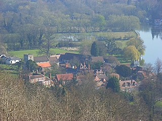
Shiplake consists of three settlements: Shiplake, Shiplake Cross and Lower Shiplake. Together these villages form a civil parish situated beside the River Thames 2 miles (3 km) south of Henley-on-Thames, Oxfordshire, England. The river forms the parish boundary to the east and south, and also the county boundary between Oxfordshire and Berkshire. The villages have two discrete centres separated by agricultural land. The 2011 Census records the parish population as 1,954 and containing 679 homes. The A4155 main road linking Henley with Reading, Berkshire passes through the parish.

<span class="mw-page-title-main">Benson, Oxfordshire</span> Village in South Oxfordshire, England

Benson is a village and civil parish in South Oxfordshire, England. The 2011 Census gave the parish population as 4,754. It lies about a mile and a half north of Wallingford at the foot of the Chiltern Hills, where a chalk stream, Ewelme Brook, joins the River Thames next to Benson Lock.

<span class="mw-page-title-main">Watlington, Oxfordshire</span> Human settlement in England

Not to be confused with the Nearby Similarly named Wallingford

<span class="mw-page-title-main">Pishill</span> Village in Oxfordshire, England

Pishill is a village and former civil parish, now in the parish of Pishill with Stonor, in the South Oxfordshire district, in the county of Oxfordshire, England. It is about 5 miles (8 km) north of Henley-on-Thames, in the Stonor valley in the Chiltern Hills about 430 feet (130 m) above sea level. In 1921 the parish had a population of 147.

<span class="mw-page-title-main">Berinsfield</span> Village in South Oxfordshire, England

Berinsfield is an English village and civil parish in South Oxfordshire, about 7 miles (11 km) southeast of Oxford. The 2011 Census recorded the parish population as 2,806.

<span class="mw-page-title-main">Bix, Oxfordshire</span> Village in Oxfordshire, England

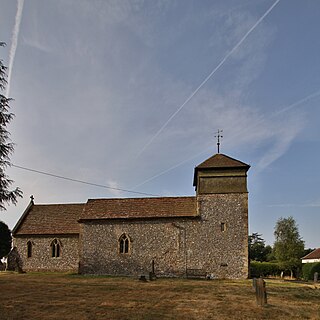
Bix is a village in the civil parish of Bix and Assendon in South Oxfordshire, about 2.5 miles (4 km) northwest of Henley-on-Thames. The village is about 130 metres (430 ft) above sea level in the Chiltern Hills.

<span class="mw-page-title-main">Stadhampton</span> Human settlement in England

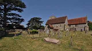
Stadhampton is a village and civil parish about 7 miles southeast of Oxford in South Oxfordshire, England. Stadhampton is close to the River Thame, a tributary of the River Thames. The village was first mentioned by name in 1146, and was in the ownership of the bishops of Lincoln, the crown, and various Oxford colleges for most of subsequent history. The village includes several buildings of historical and architectural interest, including a parish church with features dating back to the 12th-century.

<span class="mw-page-title-main">A4130 road</span> Road in England

The A4130 is a British A road which runs from a junction with the A404 at Burchetts Green (Maidenhead), Berkshire to the A417 at Rowstock in Oxfordshire. It passes through Henley-on-Thames, and Nettlebed, and bypasses Wallingford and Didcot.

<span class="mw-page-title-main">Warborough</span> Village in Oxfordshire, England

Warborough is a village and civil parish in South Oxfordshire, about 2.5 miles (4 km) north of Wallingford and about 9 miles (14 km) south of Oxford. The parish also includes the hamlet of Shillingford, south of Warborough beside the River Thames.

<span class="mw-page-title-main">Shillingford</span> Human settlement in England

Shillingford is a hamlet on the north bank of the River Thames in Warborough civil parish in South Oxfordshire, England. It lies on the A4074 between Oxford and Reading, at the junction with the A329.

<span class="mw-page-title-main">Nuffield, Oxfordshire</span> Human settlement in England

Nuffield is a village and civil parish in the Chiltern Hills in South Oxfordshire, England, just over 4 miles (6 km) east of Wallingford. The 2011 Census recorded the parish population as 939.

<span class="mw-page-title-main">Brightwell Baldwin</span> Human settlement in England

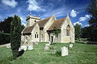
Brightwell Baldwin is a village and civil parish in Oxfordshire, about 4+12 miles (7 km) northeast of Wallingford. It was historically in the Hundred of Ewelme and is now in the District of South Oxfordshire. The 2011 Census recorded the parish's population as 208. The parish is roughly rectangular, about 2+12 miles (4 km) long north–south and about 1+14 miles (2 km) wide east–west. In 1848 the parish covered an area of 1,569 acres (635 ha). The B4009 road linking Benson and Watlington forms part of the southern boundary of the parish. The B480 road linking Oxford and Watlington forms a small part of its northern boundary. Rumbolds Lane forms much of its western boundary. For the remainder the parish is bounded largely by field boundaries.

<span class="mw-page-title-main">Marsh Baldon</span> Human settlement in England

Marsh Baldon is a village and civil parish about 5 miles (8 km) southeast of Oxford in Oxfordshire. Since 2012 it has been part of the Baldons joint parish council area, sharing a parish council with the adjacent civil parish of Toot Baldon. The 2011 Census population is 310.

Joyce Grove is a country house built in a Jacobethan style in Nettlebed, Oxfordshire, England. It is owned by Sue Ryder (charity) which, until March 2020 operated its Nettlebed Palliative Care Facility at Joyce Grove at Nettlebed in Henley-On-Thames, Oxfordshire. Joyce Grove is located approximately 67 kilometres (42 mi) west of London.

References

  1. "Area: Nettlebed CP (Parish): Key Figures for 2011 Census: Key Statistics". Neighbourhood Statistics . Office for National Statistics . Retrieved 1 December 2013.
  2. "Early history". History of Nettlebed. Nettlebed Community. Retrieved 1 September 2017.
  3. Case 1952–53, pp. 3–10.
  4. Ekwall 1960 , Nettlebed
  5. Rosevear, Alan. "Turnpike Roads in England".
  6. Historic England. "The White Hart Hotel (Grade II) (1369327)". National Heritage List for England . Retrieved 23 July 2018.
  7. Historic England. "The Bull Inn (Grade II) (1047383)". National Heritage List for England . Retrieved 23 July 2018.
  8. Historic England. "The Sun Inn Public House (Grade II) (1181154)". National Heritage List for England . Retrieved 23 July 2018.
  9. https://www.thewh.co.uk/
  10. "The White Hart - Pub/Inn in Henley-on-Thames, Oxfordshire - Visit Thames". www.visitthames.co.uk. Retrieved 22 February 2024.
  11. Nikkhah, Roya (30 September 2012). "Kate and the Middletons all smiles at wedding of family friend". The Daily Telegraph .
  12. Historic England. "25, High Street, Henley-on-Thames, Oxfordshire (Grade II) (1047382)". National Heritage List for England . Retrieved 21 November 2023.
  13. Page 1907, pp. 87–90.
  14. Sherwood & Pevsner 1974, p. 714.
  15. Historic England. "Church of St Bartholomew (Grade II) (1369329)". National Heritage List for England . Retrieved 23 July 2018.
  16. Anonymous 2012, p. 3.
  17. Anonymous 2012, p. 4.
  18. Davies, Peter (17 January 2007). "Nettlebed S Bartholomew". Dove's Guide for Church Bell Ringers . Central Council of Church Bell Ringers . Retrieved 1 December 2013.
  19. Historic England, "Sue Ryder Home (1181065)", National Heritage List for England , retrieved 15 December 2016
  20. 1 2 Mellor et al. 1994, p. 33.
  21. Mellor et al. 1994, p. 149.
  22. Mellor et al. 1994, p. 201.
  23. Historic England. "Brick Kiln (Grade II*) (1181146)". National Heritage List for England . Retrieved 23 July 2018.
  24. Foreman 1983, plates 66, 67.
  25. Foreman 1983, p. 127.
  26. 1 2 "Nettlebed Folk Club" . Retrieved 23 July 2018.
  27. "Previous winners". Radio 2 Folk Awards 2006. BBC Online . Retrieved 7 February 2011.
  28. "river rapids X38 X39 X40" (PDF). Thames Travel . Retrieved 23 July 2018.
  29. "Sir Ninian Stephen, Australia's former Governor-General and war crimes judge – obituary". The Telegraph. 29 October 2017. ISSN   0307-1235 . Retrieved 22 February 2024.
  30. Historic England. "25, High Street (Grade II) (1047382)". National Heritage List for England . Retrieved 24 July 2018.

Bibliography