
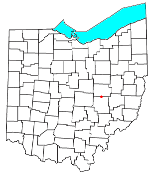
Madison County is a county in the U.S. state of Indiana. The 2020 census states the population is standing at 130,129. The county seat since 1836 has been Anderson, one of three incorporated cities within the county.
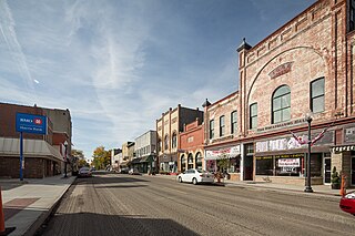
Pendleton is a town in Fall Creek Township, Madison County, Indiana, United States. The population was 4,717 at the 2020 census, up from 4,253 in 2010.

Newport is an unincorporated community in Monroe County in the U.S. state of Michigan. The community is located within Berlin Charter Township. As an unincorporated community, Newport has no legally defined boundaries or population statistics of its own but does have its own post office with the 48166 ZIP Code.
Adams Mills is a small unincorporated community in northeastern Cass Township, Muskingum County, Ohio, United States. It is located on State Route 16 four miles northeast of Dresden. Little more than a grocery stop in the early 20th century, this mostly residential community grew up around the Adams Brothers flouring mill in the 1830s.

Rosedale is an unincorporated community in central Pike Township, Madison County, Ohio, United States, and roughly thirty miles west of the city of Columbus. The ZIP code is 43029 and mail is currently delivered by the Irwin post office.

Friendship is an unincorporated community (village) in a scenic valley on State Road 62, Brown Township, Ripley County, in the U.S. state of Indiana.

Milan Township is one of twenty townships in Allen County, Indiana, United States. Milan Township is located in east central Allen County, with the Maumee River meandering across the township. As of the 2010 census, its population was 3,749. The township is highly rural, with only 1,137 houses in the 2010 census. Many of the residents of Milan Township are Swiss Amish who mostly speak a Low Alemannic Alsatian dialect. Milan township is generally demarcated by Schwartz Road to the west, Notestine Road to the north, Sampson Road to the east, and Gar Creek Road to the south.

Wanamaker is a community of Indianapolis located in southeastern Marion County, Indiana. It is situated 9 miles (14 km) southeast of downtown Indianapolis in north central Franklin Township. The community is concentrated near the intersection of Southeastern Avenue and Northeastern Avenue. The town was built along the historic Michigan Road.

Forest Township is one of fourteen townships in Clinton County, Indiana. As of the 2010 census, its population was 760 and it contained 328 housing units. The township was named for the large amount of timber it contained at the time it was organized.

Fall Creek Township is one of thirteen townships in Henry County, Indiana, United States. As of the 2010 census, its population was 4,612 and it contained 1,953 housing units.

Monroe Township is one of ten townships in Jefferson County, Indiana, United States. As of the 2010 census, its population was 374 and it contained 176 housing units.

Fall Creek Township is one of fourteen townships in Madison County, Indiana, United States. As of the 2010 census, its population was 14,695 and it contained 4,570 housing units.
Fishersburg is an unincorporated community and census-designated place (CDP) in Stony Creek Township, Madison County, Indiana, United States.

Deputy is an unincorporated community and census-designated place (CDP) in Graham Township, Jefferson County, Indiana, United States. By road it is approximately 18 miles (29 km) northwest of Madison, the county seat. As of the 2010 census it had a population of 86.

Denmark is an unincorporated community and census-designated place in northeastern Lee County, Iowa, United States. It lies along Iowa Highway 16, north of the city of Fort Madison, the county seat of Lee County. Its elevation is 722 feet (220 m) above sea level. Although Denmark is unincorporated, it has a post office with the ZIP code of 52624, that opened on April 7, 1846. The town also has a branch of Farmers Savings Bank that opened in 1935. The community is part of the Fort Madison–Keokuk, IA-MO Micropolitan Statistical Area. As of the 2020 census, its population was 425.
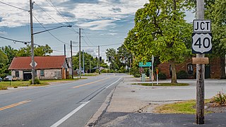
Summerford is an unincorporated community in Somerford Township, Madison County, Ohio, United States. It is located at 39°56′00″N83°29′30″W, at the intersection of U.S. Route 40 and State Route 56.
Weaver is an unincorporated community in Liberty Township, Grant County, Indiana. Weaver's first settlers were free people of color who migrated from North Carolina and South Carolina to Grant County in the early 1840s. The neighborhood was originally known as Crossroad; however, it was later renamed Weaver in honor of a prominent family of the community. The rural settlement reached its peak in the late 1800s, when its population reportedly reached 2,000. Many of its residents left the community for higher-paying jobs in larger towns during the Indiana's natural gas boom, but more than 100 families remained in the settlement in the early 1920s. Weaver, as with most of Indiana's black rural settlements, no longer exists as a self-contained community, but Weaver Cemetery remains as a community landmark.
Roberts Settlement was an early rural settlement in Jackson Township, Hamilton County, Indiana. Dating from the 1830s, its first settlers were free people of color, most of whom migrated from Beech Settlement, located 40 miles (64 km) southeast in rural Rush County, Indiana. Many of Roberts Settlement's early pioneers were born in eastern North Carolina and Virginia. Some of its settlers were ex-slaves. The neighborhood received its name from the large contingent of its residents who had the surname of Roberts. By the 1870s the farming community had a population of approximately 300 residents. In the late nineteenth and early twentieth centuries, the settlement's population began to decline, largely due to changing economic conditions that included rising costs of farming. Fewer than six families remained at the settlement by the mid-1920s. Most of Indiana's early black rural settlements, including Roberts Settlement, no longer exist. Roberts Chapel, listed on the National Register of Historic Places, serves as the site for the community's annual reunions of its friends and the descendants of former residents.

Cool Springs Township is a non-functioning administrative division of Iredell County, North Carolina, United States. By the requirements of the North Carolina Constitution of 1868, the counties were divided into townships, which included Cool Springs township as one of sixteen townships in Iredell County.


