
A severe thunderstorm warning is a type of public warning for severe weather that is issued by weather forecasting agencies worldwide when one or more severe thunderstorms have been detected by Doppler weather radar, observed by weather spotters, or reported by an emergency management agency, law enforcement, or the general public. Unlike a watch, a warning is issued to areas in the direct path of active severe thunderstorms, that are expecting a direct impact typically within an hour. Severe thunderstorms can cause property damage and injury due to large hail, high winds, and flooding due to torrential rainfall. The exact criteria to issue a warning varies from country to country.

In meteorology, a downburst is a strong downward and outward gushing wind system that emanates from a point source above and blows radially, that is, in straight lines in all directions from the area of impact at surface level. Capable of producing damaging winds, it may sometimes be confused with a tornado, where high-velocity winds circle a central area, and air moves inward and upward. These usually last for seconds to minutes. Downbursts are particularly strong downdrafts within thunderstorms.
The heat wave of 1995 derecho series are a series of derechos that occurred from July 11 through July 15, 1995, primarily impacting areas from Montana to the US Midwest, and the Great Lakes Region.

The Independence Day Derecho of 1977 was a derecho, or long-lived windstorm associated with a fast-moving band of thunderstorms, that swept across the Great Lakes region of the U.S. on July 4, 1977. It lasted around 15½ hours. The derecho formed in Minnesota around 10 a.m. CDT on July 4 and became more intense around noon in the central part of the state. The derecho produced winds of 80–100 mph (130–160 km/h) in northern Wisconsin, felling thousands of trees.
The Boundary Waters–Canadian Derecho was an international derecho that occurred during the afternoon and evening hours of July 4 and the early morning hours of July 5, 1999. It traveled 1,300 miles (2,092 km) and lasted 22 hours.
The Southern Great Lakes Derecho of 1991 is the derecho event that occurred on July 7 and 8, 1991. It lasted 17 hours and raced from South Dakota through southern Michigan before dying out over Western Pennsylvania.
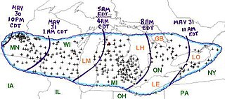
The Late-May 1998 tornado outbreak and derecho was a historic tornado outbreak and derecho that began on the afternoon of May 30 and extended throughout May 31, 1998, across a large portion of the northern half of the United States and southern Ontario from southeastern Montana east and southeastward to the Atlantic Ocean. The initial tornado outbreak, including the devastating Spencer tornado, hit southeast South Dakota on the evening of May 30. The Spencer tornado was the most destructive and the second-deadliest tornado in South Dakota history. A total of 13 people were killed; 7 by tornadoes and 6 by the derecho. Over two million people lost electrical power, some for up to 10 days.
A destructive series of tornadoes in damage struck the Northeastern United States on July 10, 1989. The storm system affected five states with severe weather, including hail up to 2.5 inches (6.4 cm) across, thunderstorm winds up to 90 mph (140 km/h), and 17 tornadoes. Several towns in New York and Connecticut were particularly hard-hit. Several homes were leveled in Schoharie, New York and extensive damage occurred in Bantam, Connecticut. A large section of Hamden, Connecticut, including an industrial park and hundreds of homes, was destroyed; and in some places, buildings were flattened to the ground.
The heat wave of 2006 derecho series were a set of derechos — severe winds with powerful thunderstorms — that occurred on July 17–21, 2006. The first storms hit a wide swath of north-central and northeastern North America that stretched from the Upper Midwest through much of Ontario and into the northeastern United States. Another round struck the middle Mississippi River Valley, including two derechos that hit St. Louis, Missouri. The storms left more than three million people without power, some more than once and some for weeks.
The Corn Belt derecho was a progressive derecho which affected a large area of the central United States on June 29, 1998. In the morning, thunderstorms, including a supercell, developed over South Dakota and tracked into central Iowa. As the thunderstorms reached central Iowa, a strong rear-inflow jet developed which caused the thunderstorm to take on a different characteristic, becoming a derecho. It traveled more than 600 miles in about ten hours, causing more than $125 million worth of widespread damage destruction, especially to crops, and was responsible for power outages to nearly a half a million people.
On February 10–11, 2009, a broad-scale damaging wind event and small tornado outbreak affected the Central and Eastern United States. During the two-day period, 14 tornadoes touched down in seven states. Oklahoma was struck by six tornadoes, the most of any state. The six tornadoes in Oklahoma also tied the record for the most tornadoes ever recorded in the state during the month of February, which would later be broken in 2023. The first day of the outbreak produced the most tornadoes; the second brought mainly high wind damage and rain or snow in most of the Northeast.

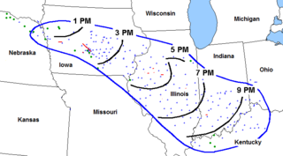
The May 2009 Southern Midwest Derecho was an extreme progressive derecho and mesoscale convective vortex (MCV) event that struck southeastern Kansas, southern Missouri, and southwestern Illinois on May 8, 2009. Thirty-nine tornadoes, including two of EF3 strength on the Enhanced Fujita Scale, were reported in addition to high non-tornadic winds associated with the derecho and MCV. Due to the abnormal shape of the storm on radar and the extremely strong winds, many called this an "inland hurricane." A new class of storm, the Super Derecho, has been used to describe this event after analysis in 2010. Embedded supercells produced hail up to baseball size in southern Missouri, a rare event in a derecho. A wind gust of 106 mph (171 km/h) was recorded by a backup anemometer at the Southern Illinois Airport after official National Weather Service equipment failed. This derecho was the last of a series of derechos that occurred at the beginning of May.

This page documents the tornadoes and tornado outbreaks of 1998, primarily in the United States. Most tornadoes form in the U.S., although some events may take place internationally. Tornado statistics for older years like this often appear significantly lower than modern years due to fewer reports or confirmed tornadoes, however by the 1990s tornado statistics were coming closer to the numbers we see today.

The June 2010 Northern Plains tornado outbreak was one of the most prolific summer tornado outbreaks in the Northern Great Plains of the United States on record. The outbreak began on June 16, with several tornadoes in South Dakota and Montana. The most intense storms took place the following day across much of eastern North Dakota and much of Minnesota. The system produced 93 tornadoes reported across four states while killing three people in Minnesota. Four of the tornadoes were rated as EF4 on the Enhanced Fujita scale, the most violent tornadoes in a 24-hour period since there were five within 15 hours in the 2008 Super Tuesday tornado outbreak. This was the region's first major tornado outbreak of the year and one of the largest on record in the region, comparable to a similar outbreak in June 1992. The 48 tornadoes that touched down in Minnesota on June 17 marked the most active single day in the state's history. June 17 was the second largest tornado day on record in the meteorological summer, behind the most prolific day of the 2003 South Dakota tornado outbreak on June 24, 2003.

The 2010 Bronx tornado was a rare EF1 tornado which struck the Bronx in New York City, United States, touching down there on July 25, 2010 and traveled 1 mi (1.6 km). The tornado, which was the second ever tornado recorded in the Bronx, touched down around 2:55 p.m. EDT in Riverdale, located within the Bronx, causing damage to buildings, trees, cars, and power lines. Seven people were injured along its track due to broken glass. The tornado lifted around 3:00 p.m. EDT while still within the Riverdale neighborhood.
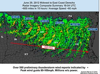
The June 2012 Mid-Atlantic and Midwest derecho was one of the deadliest and most destructive fast-moving severe thunderstorm complexes in North American history. The progressive derecho tracked across a large section of the Midwestern United States and across the central Appalachians into the mid-Atlantic states on the afternoon and evening of June 29, 2012, and into the early morning of June 30, 2012. It resulted in a total of 22 deaths, millions of power outages across the entire affected region, and a damage total of US$2.9 billion which exceeded that of all other derecho events aside from the August 2020 Midwest derecho. The storm prompted the issuance of four separate severe thunderstorm watches by the Storm Prediction Center. A second storm in the late afternoon caused another watch to be issued across Iowa and Illinois.

On the morning and early afternoon of June 3, 2020, a powerful derecho crossed Pennsylvania and New Jersey, causing four confirmed fatalities. It was the deadliest derecho in the region since 1950.
The May 2022 Canadian derecho was a high-impact derecho event that affected the Quebec City-Windsor Corridor, Canada's most densely populated region, on May 21, 2022. Described by meteorologists as a historic derecho and one of the most impactful thunderstorms in Canadian history, winds up to 190 km/h (120 mph) as well as around four tornadoes caused widespread and extensive damage along a path that extended for 1,000 kilometres (620 mi).


