Brownhills is a town in the Metropolitan Borough of Walsall, West Midlands, England. A few miles south of Cannock Chase and close to the large Chasewater reservoir, it is 6 miles (9.7 km) northeast of Walsall, a similar distance southwest of Lichfield and 13 miles (20.9 km) miles north-northwest of Birmingham. It is part of the Aldridge-Brownhills parliamentary constituency and neighbours the large suburban villages of Pelsall and Walsall Wood. It lies within the boundaries of the historic county of Staffordshire.
South Staffordshire is a local government district in Staffordshire, England. Its council is based in Codsall. Other notable settlements include Brewood, Cheslyn Hay, Coven, Essington, Featherstone, Four Ashes, Great Wyrley, Huntington, Kinver, Landywood, Penkridge, Perton, Wedges Mills, Weston-under-Lizard and Wombourne. The district covers a largely rural area lying immediately to the west and north-west of the West Midlands conurbation.
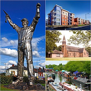
The Metropolitan Borough of Walsall is a metropolitan borough in the West Midlands, England. It is named after its largest settlement, Walsall, but covers a larger area which also includes Aldridge, Bloxwich, Brownhills, Darlaston, Pelsall and Willenhall.
Wednesfield is a town and historic village in the City of Wolverhampton, West Midlands, England, It is 2 miles (3.2 km) east-northeast of Wolverhampton city centre and about 10 miles (16 km) from Birmingham and is part of the West Midlands conurbation. It was historically within the county of Staffordshire.

Rushall Olympic Football Club is an English football club based in Rushall, a former mining village that forms part of the Metropolitan Borough of Walsall. The team competes in the National League North, the sixth tier of the English football league system.

The Chase Line is a suburban railway line in the West Midlands region of England. It runs from its southern terminus, Birmingham New Street, to Walsall, and then Rugeley Trent Valley in Staffordshire, where it joins the Trent Valley line. The name of the line refers to Cannock Chase which it runs through at its northern end.

Shenstone is a village and civil parish in The Lichfield District, Staffordshire, England, located between Lichfield and Sutton Coldfield. The parish also contains the village of Stonnall.

Walsall railway station is the principal railway station of Walsall, West Midlands, England and situated in the heart of the town. It is operated by West Midlands Trains, with services provided by West Midlands Railway. The main entrance is situated inside the Saddlers Shopping Centre.

Great Wyrley is a village and civil parish in the South Staffordshire district of Staffordshire, England. It forms a built up area with nearby Cheslyn Hay, Churchbridge, Landywood and Little Wyrley. It lies 6 miles north of Walsall and a similar distance from Wolverhampton. Cannock is directly north of the village. It had a population of 11,060 at the 2011 census.

The A454 is a major road in central England. It runs 28.9 miles (46.5 km) from Bridgnorth to Sutton Coldfield and is an important primary route linking Wolverhampton and Walsall with the M6 motorway.

Essington is a village and civil parish in South Staffordshire, England, located near the city of Wolverhampton and towns of Walsall, Bloxwich, Cannock and Brewood. The villages of Cheslyn Hay, Great Wyrley, Coven, Penkridge and Featherstone are also nearby. The village forms part of the Staffordshire/West Midlands border.

Pelsall is a village and civil parish in the Metropolitan Borough of Walsall, West Midlands, England. Forming part of the borough's border with Staffordshire, Pelsall is located 4 miles north of Walsall, midway between the towns of Bloxwich and Brownhills and 4 miles northwest of Aldridge. The southern edge of Cannock Chase is 6 miles to the north. Pelsall is also 8 miles southwest of Lichfield and 8 miles northeast of Wolverhampton.
The South Staffordshire line is a partially mothballed and active former mainline that connects Burton-upon-Trent to Lichfield in Staffordshire and formerly then to the West Midlands towns of Walsall, Wednesbury, Dudley and Stourbridge. However, Dudley and Stourbridge were already joined to the Oxford, Worcester and Wolverhampton Railway's (OW&WR) line just north of Dudley Station. It in essence, continued to Stourbridge along with Wednesbury and Walsall.

Landywood is a village in the South Staffordshire district of Staffordshire, England. Landywood is part of the South Staffordshire ward named "Great Wyrley Landywood", It lies 3 miles north of Bloxwich, 3 miles south from Cannock and 6 miles north of Walsall.

Rushall railway station was a station serving the villages of Blakenall Heath and Rushall in the Metropolitan Borough of Walsall, England. It was on the South Staffordshire Line between Walsall and Lichfield.

Pelsall railway station is a disused railway station that served the villages of Pelsall and Shelfield in the Metropolitan Borough of Walsall, West Midlands, England. It was on the South Staffordshire Line between Walsall and Lichfield.

Brownhills railway station is a disused railway station that served the town of Brownhills and the village of Clayhanger in the Metropolitan Borough of Walsall, West Midlands. It was on the South Staffordshire Line between Walsall and Lichfield.

Rushall is a suburb in the Metropolitan Borough of Walsall in the West Midlands, England. It is centred on the main road between Walsall and Lichfield. It is mentioned in the Domesday Book but has mostly developed since the 1920s. Rushall was historically a part of the county of Staffordshire before it was incorporated with much of the old Aldridge-Brownhills Urban District into the modern-day Walsall district.
Brownhills West is a suburban village of Brownhills in the Walsall Metropolitan Borough and forms part of the border of the West Midlands and Staffordshire. It is an unparished area of Brownhills, lying on the border with Cannock and Burntwood respectively, it is still part of the Walsall borough. It lies next to the suburbs of Newtown, Ogley Hay and Shire Oak of Brownhills. The town is 13 miles Northwest of Birmingham City Centre.
The South Staffordshire and Birmingham District Steam Tramways Company which became the South Staffordshire Tramways Company operated a tramway service from their depot in Wednesbury between 1883 and 1924.

