Niagara Parkway

Last updated

Niagara Parkway

Niagara Boulevard
Route information
Maintained by the Niagara Parks Commission
Length55.0 km [1]  (34.2 mi)
Major junctions
South end Old Fort ErieFort Erie
North end Fort GeorgeNiagara-on-the-Lake
Location
Country Canada
Province Ontario
Highway system
  • Parkways of the Great Lakes

The Niagara Parkway, formerly known as Niagara Boulevard and historically as the Niagara Road, is a scenic road in the province of Ontario that travels on the Canadian side of the Niagara River from the town of Fort Erie to Niagara-on-the-Lake. The portion north of Table Rock in the city of Niagara Falls is designated as an Ontario Scenic Highway. Niagara Boulevard originally referred only to the section from Fort Erie to Chippawa.

Contents

The Niagara Parkway begins at Fort Erie in the south. It passes through several villages along the river before passing through the tourist district of Niagara Falls. North of the city it provides access to several attractions, including the Whirlpool Rapids, Butterfly Conservatory, and Brock's Monument at Queenston Heights. The route ends at Fort George, southeast of the urban centre of Niagara-on-the-Lake.

Construction on the modern Niagara Parkway began in 1908; it was completed from Lake Erie to Lake Ontario in 1931 as a scenic road with gardens and manicured lawns throughout its length. The parkway was referred to by Sir Winston Churchill, having been driven down it, as "the prettiest Sunday afternoon drive in the world." [2]

Route description

The parkway winds along the western shore of the Niagara River. North of the falls it is within metres of the river. Niagara Parkway.png
The parkway winds along the western shore of the Niagara River. North of the falls it is within metres of the river.

The Niagara Parkway is a two-lane minor arterial road with a 60 km/h (37 mph) speed limit for the majority of its length, although the section from Hiram Street to Upper Rapids Boulevard in Niagara Falls is a four lane divided road signed at 40 km/h (25 mph). It is 55 km (34 mi) in length, crossing the entire Niagara Peninsula between Lake Erie and Lake Ontario. [3] [4] The route falls under the jurisdiction of the Niagara Parks Commission, an agency of the Government of Ontario, for most of its length. However, the section from Hiram Street to Glenview Avenue belongs to the City of Niagara Falls. [5] Despite this, it is still signed as part of the Niagara Parkway. [3] The Niagara River Recreation Trail, a mixed-use pedestrian and cycling path, follows 53 km (33 mi) of the length of the parkway between Niagara-on-the-Lake and Fort Erie. [2]

The parkway begins at the old Fort Erie, south of the Peace Bridge, where it is known as Lakeshore Road and connects with the Queen Elizabeth Way (QEW) and the former Highway 3. East of the Mather Circle, the road becomes known as Niagara Parkway and proceeds north through downtown Fort Erie, beneath the International Railway Bridge. It gradually curves to the east opposite the southern shore of Grand Island. Houses line the southern side of the parkway along this section. The road curves back northward as it crosses the Black Creek and passes through a sparsely populated stretch. It passes the Willoughby Historical Museum followed by the Legends on the Niagara Golf Course. Shortly thereafter, it enters the City of Niagara Falls and meets the Welland River. Traffic is diverted west to cross the river at Portage Road, where it then resumes on the Niagara Parkway at King's Bridge Park. [6]

Following the excavation of the Chippawa Cut in 1829, the Niagara Road became heavily used as a tow road for ships exiting the Welland Canal Niagara Parkway Chippawa Cut.png
Following the excavation of the Chippawa Cut in 1829, the Niagara Road became heavily used as a tow road for ships exiting the Welland Canal

The Niagara Parkway travels alongside the Upper Rapids and passes adjacent to Horseshoe Falls. [4] It crosses through Queen Victoria Park and enters downtown Niagara Falls, where it is known as River Road north of Clifton Hill. The parkway passes below the Rainbow Bridge; side streets provide access to Highway 420, but River Road itself does not meet it. As the road progresses north, it passes beneath the Whirlpool Rapids Bridge before wrapping around the Whirlpool Rapids. At Victoria Avenue, River Road becomes the Niagara Parkway again. [6] The parkway passes the Butterfly Conservatory and crosses the Sir Adam Beck Hydroelectric Power Stations. [3] Shortly thereafter, it passes by the Niagara Floral Clock, one of the largest floral clocks in the world with a diameter of 12.2 m (40 ft). [4] It passes beneath Highway 405 at the Lewiston–Queenston Bridge; the Parkway's interchange with Highway 405 was removed by December 2006. [7]

North of the bridge, the route descends the Niagara Escarpment near Brock's Monument, a column which commemorates the death of Sir Isaac Brock during the Battle of Queenston Heights. At the bottom of the escarpment, the route passes the village of Queenston. [8] The parkway meanders north, parallel to the river, with houses lining the western side. Approaching the town of Niagara-on-the-Lake, the road becomes known as Queen's Parade. It diverges from the river and travels northwest towards the town, ending at Fort George. [3]

History

By 1955, Niagara Boulevard more-or-less resembled the modern parkway Niagara Parkway, November 12, 1954.png
By 1955, Niagara Boulevard more-or-less resembled the modern parkway

The Niagara Parkway is one of the oldest roads in Ontario. Predating it, an aboriginal trail along the west side of the Niagara River existed before the arrival of Europeans. [9] The first survey along the length of the river was done by Augustus Jones in 1786. The survey set aside a one chain reserve along the bank of the river for military purposes; one chain being equivalent to 20 metres (66 ft). [10] Despite this reserve, early settlers extended their fences to the river. In 1791, the Land Board ordered that the fences be removed to permit the reserve's use as a public road. The Niagara Road quickly became the primary route between Fort Erie and Fort George. Its importance grew with the declaration of war against the Americans in June 1812. During the war, the road became vital for the movement of militia and supplies, and accordingly it was one of the primary frontiers of the war. [9]

When the First Welland Canal was opened in 1829, the Niagara Road became a towpath for vessels exiting the Welland River. Oxen on the road would tow boats against the rapid current of the Niagara River as they exited the canal and continued south to Lake Erie. In 1833, a large cut was made to connect the canal with Port Colborne, eliminating the use of the road as a towpath. It continued to be used as a public road until the government gave the reserve to the Niagara Parks Commission in 1891. [9]

Niagara Parkway through Niagara Falls, 2012 Niagara falls parkway 04.07.2012 16-23-14.jpg
Niagara Parkway through Niagara Falls, 2012

In 1908, after receiving approval from the government, the Parks Commission began to expropriate land along the length of the river. The broadened strip of land was used to construct a new paved parkway, which was opened in segments. [10] The new parkway was ornamental and designed to be aesthetically pleasing, a prime consideration of road construction at that time. [9] The section south of the falls was completed first, opening in 1912. It was extended north to the Whirlpool Rapids, incorporating the existing River Road, by 1915. The section between the rapids and Queenston was opened between 1921 and 1923. Finally, the remaining section between Queenston and Niagara-on-the-Lake opened in 1931, completing the present parkway. [10]

In mid-August 1943, Winston Churchill came to Canada to attend the Quebec Conference, a then-secret meeting in Quebec City to discuss a strategy for the invasion of France during World War II (which would come to be known as D-Day). Prior to the conference, he met with William Lyon Mackenzie King several times. Between the meetings and conference, Churchill visited Niagara Falls and was driven along the Niagara Parkway, after which he described it as "the prettiest Sunday afternoon drive in the world." [2]

On May 30, 1977, the City of Niagara Falls assumed River Road between Hiram Street, north of the Rainbow Bridge, and Glenview Avenue, east of Victoria Avenue. This section is still designated as part of the Niagara Parkway despite not being under the jurisdiction of the Niagara Parks Commission. [5]

Major intersections

The following table lists the major junctions along Niagara Parkway. [1] The entire route is located in the Regional Municipality of Niagara. [3]  

Locationkm [1] miDestinationsNotes
Fort Erie 0.00.0 Fort Erie Access to Queen Elizabeth Way and Ontario Highway 3 via Central Avenue; Mather Circle was the terminus for the QEW before the current border plaza was built; Fort Erie
2.61.6RR 17 jct blue.svg  Regional Road 17 (Bertie Street)
5.43.4RR 124 jct blue.svg  Regional Road 124 (Central Avenue)
Black Creek16.310.1RR 25 jct blue.svg  Regional Road 25 (Netherby Road)
Chippawa 27.417.0RR 49 jct blue.svg  Regional Road 49 north (Portage Road)
RR 47 jct blue.svg  Regional Road 47 west (Main Street)
Parkway detours to cross Welland River
Niagara Falls 32.420.1Ontario To 420 crown.svg Falls Avenue to Highway 420
32.620.3 Clifton Hill Tourist district for Niagara Falls
34.821.6Queen Street
36.822.9Victoria Avenue
Queenston 42.426.3Ontario 405 crown.svg  Highway 405 west – St. Catharines, Toronto Ramp removed in December 2006 [7]
44.027.3RR 81 jct blue.svg  Regional Road 81 west (York Road) – St. Catharines
Niagara-on-the-Lake 55.034.2 Fort George
1.000 mi = 1.609 km; 1.000 km = 0.621 mi
  •       Closed/former

See also

Related Research Articles

<span class="mw-page-title-main">Niagara River</span> River in New York, United States and Ontario, Canada

The Niagara River is a river that flows north from Lake Erie to Lake Ontario. It forms part of the border between the province of Ontario in Canada and the state of New York in the United States. There are differing theories as to the origin of the river's name. According to Iroquoian scholar Bruce Trigger, Niagara is derived from the name given to a branch of the locally residing native Neutral Confederacy, who are described as being called the Niagagarega people on several late-17th-century French maps of the area. According to George R. Stewart, it comes from the name of an Iroquois town called Ongniaahra, meaning "point of land cut in two".

The Queen Elizabeth Way (QEW) is a 400-series highway in the Canadian province of Ontario linking Toronto with the Niagara Peninsula and Buffalo, New York. The freeway begins at the Peace Bridge in Fort Erie and travels 139.1 kilometres (86.4 mi) around the western end of Lake Ontario, ending at Highway 427 in Toronto. The physical highway, however, continues as the Gardiner Expressway into downtown Toronto. The QEW is one of Ontario's busiest highways, with an average of close to 200,000 vehicles per day on some sections. Major highway junctions are at Highway 420 in Niagara Falls, Highway 405 in Niagara-on-the-Lake, Highway 406 in St. Catharines, the Red Hill Valley Parkway in Hamilton, Highway 403 and Highway 407 in Burlington, Highway 403 at the Oakville–Mississauga boundary, and Highway 427 in Etobicoke. Within the Regional Municipality of Halton the QEW is signed concurrently with Highway 403. The speed limit is 100 km/h (62 mph) throughout most of its length, with the exceptions being between Hamilton and St. Catharines where the posted limit is 110 km/h (68 mph).

<span class="mw-page-title-main">Niagara Peninsula</span> Peninsula in Ontario, Canada

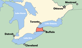
The Niagara Peninsula is an area of land lying between the southwestern shore of Lake Ontario and the northeastern shore of Lake Erie, in Ontario, Canada. Technically an isthmus rather than a peninsula, it stretches from the Niagara River in the east to Hamilton, Ontario, in the west. The peninsula is located in the Golden Horseshoe region of Southern Ontario, and has a population of roughly 1,000,000 residents. The region directly across the Niagara River and Lake Erie in New York State is known as the Niagara Frontier.

<span class="mw-page-title-main">Regional Municipality of Niagara</span> Regional municipality in Ontario, Canada

The Regional Municipality of Niagara, also colloquially known as the Niagara Region or Region of Niagara, is a regional municipality comprising twelve municipalities of Southern Ontario, Canada. The regional seat is in Thorold. It is the southern end of the Golden Horseshoe, the largest megalopolis in Canada.

Chippawa is a community located within the city of Niagara Falls, Ontario.

<span class="mw-page-title-main">Ontario Highway 3</span> Ontario provincial highway

King's Highway 3, commonly referred to as Highway 3, is a provincially maintained highway in the Canadian province of Ontario which travels parallel to the northern shoreline of Lake Erie. It has three segments, the first of which travels from the Ambassador Bridge in Windsor to Highway 77 in Leamington. The second portion begins at Talbotville Royal outside of St. Thomas at Highway 4, and travels to the western city limits of Port Colborne. The road is regionally maintained within Port Colborne as Niagara Regional Road 3, but regains its provincial designation at Highway 140. Its third and final terminus is at Edgewood Park, within the Fort Erie town limits. From there, the road continues as Niagara Regional Road 3 to the Peace Bridge, where drivers can cross to the United States. The total length of Highway 3 is 258.2 km (160.4 mi), consisting of 49.2 km (30.6 mi) from Windsor to Leamington, 187.9 km (116.8 mi) from Talbotville Royal to Port Colborne and 21.1 km (13.1 mi) from Port Colborne to Edgewood Park.

<span class="mw-page-title-main">Interstate 190 (New York)</span> Highway in New York

Interstate 190 is a north–south auxiliary Interstate Highway in the United States that connects I-90 in Buffalo, New York, with the Canada–United States border at Lewiston, New York, near Niagara Falls. Officially, I-190 from I-90 north to New York State Route 384 (NY 384) is named the Niagara Thruway and is part of the New York State Thruway system. The remainder, from NY 384 to Lewiston, is known as the Niagara Expressway and is maintained by the New York State Department of Transportation (NYSDOT).

<span class="mw-page-title-main">Niagara Gorge</span> Canyon on the border between New York, USA and Ontario, Canada

Niagara Gorge is an 11 km (6.8 mi) long canyon carved by the Niagara River along the Canada–United States border, between the U.S. state of New York and the Canadian province of Ontario. It begins at the base of Niagara Falls and ends downriver at the edge of the geological formation known as the Niagara Escarpment near Queenston, Ontario, where the falls originated about 12,500 years ago. The position of the falls has receded upstream toward Lake Erie because of the falling waters' slow erosion of the riverbed's hard Lockport dolomite, combined with rapid erosion of the relatively soft layers beneath it. This erosion has created the gorge.

King's Highway 20, commonly referred to as Highway 20, is a provincially maintained highway in the Canadian province of Ontario. Presently, it is a short 1.9 km (1.2 mi) stub between Highway 58 and Niagara Regional Road 70 in the City of Thorold, but until 1997 it connected Hamilton to Niagara Falls, serving several towns atop the Niagara Escarpment en route.

The Niagara Parks Commission, commonly shortened to Niagara Parks, is an agency of the Government of Ontario which maintains the Ontario shoreline of the Niagara River.

<span class="mw-page-title-main">New York State Route 18</span> Highway in New York

New York State Route 18 (NY 18) is an east–west state highway in western New York in the United States. It runs parallel to the south shore of Lake Ontario for most of its length between Niagara County and Monroe County. NY 18, which also passes through Orleans County, acts as a northerly alternate to NY 104, another east–west route that parallels NY 18 to the south on Ridge Road. The western terminus of NY 18 is at a complex grade-separated interchange with NY 104 outside the village of Lewiston. Its eastern terminus is at a junction with NY 104 in an area of Rochester known as Eastman Business Park.

<span class="mw-page-title-main">New York State Route 18F</span> Highway in New York

New York State Route 18F (NY 18F) is a 9.80-mile (15.77 km) long state highway in northwestern Niagara County, New York, in the United States. The southern terminus of the route is at an interchange with NY 104 and the Niagara Scenic Parkway just east of the village of Lewiston. The northern terminus is at an intersection with NY 18 near Four Mile Creek State Park in Porter. NY 18F parallels NY 18 for most of its alignment, taking a more westerly course than its parent. NY 18F is the only remaining suffixed route of NY 18.

<span class="mw-page-title-main">Niagara Scenic Parkway</span>

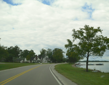
The Niagara Scenic Parkway is a 16.4-mile (26.39 km) long north–south highway in western Niagara County, New York, in the United States. Its southern terminus is at the LaSalle Expressway on the east bank of the Niagara River in Niagara Falls. The northern terminus is at New York State Route 18 (NY 18) at Four Mile Creek State Park in Porter near Lake Ontario. Originally, the parkway was one continuous road; however, due to low usage, a portion of the parkway near Niagara Falls was removed, separating the parkway into two sections. The length of the parkway is designated as New York State Route 957A by the New York State Department of Transportation (NYSDOT). A 1.16-mile (1.87 km) long spur connecting the Niagara Scenic Parkway to Fort Niagara State Park near Youngstown is designated as New York State Route 958A. Both reference route designations are unsigned.

<span class="mw-page-title-main">New York State Route 384</span> State highway in western New York, US

New York State Route 384 (NY 384) is a state highway in Western New York in the United States. It is a north–south route extending from the city of Buffalo, Erie County to the city of Niagara Falls, Niagara County, and is one of several routes directly connecting the two cities. The southern terminus of the route is at NY 5 in downtown Buffalo. NY 384's northern terminus is at the Rainbow Bridge in downtown Niagara Falls. Through its entire course in Erie County, it is known as Delaware Avenue for the street it follows in the city. In Niagara County, NY 384 follows the Niagara River and is named River Road and Buffalo Avenue.

<span class="mw-page-title-main">Niagara Gorge Railroad</span> Trolley line between Niagara Falls and Lewiston, New York (1895–1935)

The Niagara Gorge Railroad was an interurban railway which ran at the bottom of the Niagara Gorge from Niagara Falls, New York to Lewiston, New York.

<span class="mw-page-title-main">New York State Route 182</span> State highway in Niagara County, New York, US

New York State Route 182 (NY 182) is a 6.18-mile (9.95 km) state highway in Niagara County, New York, in the United States. It serves as a signed connection between the Whirlpool Rapids Bridge over the Niagara River and the Niagara Falls International Airport east of the city of Niagara Falls. From the bridge, NY 182 runs across the city of Niagara Falls, following several local streets as it makes its way to an intersection with U.S. Route 62 (US 62) in Wheatfield. The route was originally designated as New York State Route 18D in the early 1930s. It gained its current designation on January 1, 1962.

<span class="mw-page-title-main">Great Lakes Seaway Trail</span>

The Great Lakes Seaway Trail, formerly named and commonly known as the Seaway Trail, is a 518-mile (834 km) National Scenic Byway in the northeastern United States, mostly contained in New York but with a small segment in Pennsylvania. The trail consists of a series of designated roads and highways that travel along the Saint Lawrence Seaway—specifically, Lake Erie, the Niagara River, Lake Ontario, and the Saint Lawrence River. It begins at the Ohio state line in rural Erie County, Pennsylvania, and travels through several cities and villages before ending at the Seaway International Bridge northeast of the village of Massena in St. Lawrence County, New York. It is maintained by the non-profit Seaway Trail, Inc.

References

  1. 1 2 3 Google (February 16, 2010). "Niagara Parkway length and route" (Map). Google Maps . Google. Retrieved February 16, 2010.
  2. 1 2 3 "Niagara River Recreation Trail". Niagara Parks Commission. Retrieved February 13, 2011.
  3. 1 2 3 4 5 Southcentral Ontario (Map). Cartography by MapArt. Peter Heiler Ltd. 2008. § Q35–U36. ISBN   978-1-55368-221-9.
  4. 1 2 3 "Explore The Niagara Parkway". Tourism Niagara. Archived from the original on November 29, 2010. Retrieved February 13, 2011.
  5. 1 2 Bylaw 77-114. May 30, 1977. City of Niagara Falls
  6. 1 2 Golden Horseshoe (Map). Cartography by Rand McNally. Allmaps Canada. 1996. pp. 349–350, 354. § G13–J18. ISBN   978-0-88640-767-4.
  7. 1 2 D. Hackston; R. Taylor; P. Skorochod; G.W. English; P. Heimrath; J. MacDonald (March 2007). Eastern Ontario Transportation Logistics Study (PDF) (Report). Northumberland County. pp. 20–21. Archived from the original (PDF) on March 2, 2012. Retrieved June 28, 2010.
  8. Cruikshank, Ernest A. (1964). "The Battle of Queenston Heights". In Zaslow, Morris (ed.). The Defended Border . Toronto: Macmillan of Canada. ISBN   0-7705-1242-9.
  9. 1 2 3 4 "A History of the Niagara Parkway". A Journey Through History: A Guide to the Niagara Parkway from Chippawa to Black Creek. Willoughby Historical Museum. 2002. pp. 21–22. ISBN   978-0-9688996-6-3.
  10. 1 2 3 Berketa, Rick. "Niagara Parks: A History & Pictorial". Niagara Falls Thunder Alley. Retrieved February 11, 2011.
Template:Attached KML/Niagara Parkway
KML is from Wikidata