Primera is a town in Cameron County, Texas, United States, near Combes. The population was 4,070 at the 2010 census. It is part of the Brownsville–Harlingen–Raymondville and the Matamoros–Brownsville metropolitan areas.

Titus County is a county located in the northeastern region of the U.S. state of Texas. As of the 2020 census, its population was 31,247. Its county seat is Mount Pleasant. The county is named for Andrew Jackson Titus, an early settler. Titus County comprises the Mount Pleasant micropolitan statistical area.

Parmer County is a county located in the southwestern Texas Panhandle on the High Plains of the Llano Estacado in the U.S. state of Texas. As of the 2020 Census, the population was 9,869. The county seat is Farwell. The county was created in 1876 and later organized in 1907. It is named in honor of Martin Parmer, a signer of the Texas Declaration of Independence and early judge. Parmer County was one of 10 prohibition, or entirely dry, counties in the state of Texas, but is now a wet county.

Cooke County is a county in the U.S. state of Texas. At the 2020 census, its population was 41,668. The county seat is Gainesville. The county was founded in 1848 and organized the next year. It is named for William Gordon Cooke, a soldier during the Texas Revolution. It is a part of the Texoma region.

Burleson County is a county located in the U.S. state of Texas. As of the 2020 census, the population was 17,642. Its county seat is Caldwell. The county is named for Edward Burleson, a general and statesman of the Texas Revolution.

Bennsville is a census-designated place (CDP) in Charles County, Maryland, United States. Per the 2020 census, the population was 15,288. The area is not an official postal designation, but is part of the Waldorf or Pomfret postal area. The Bennsville area is growing with new residential development, encouraged by the extension in the 1990s of Maryland Route 228 which provides quick access to Maryland Route 210. Bennsville has experienced the 2006 opening of North Point High School and the straightening of Middletown Road in 2008.

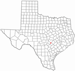
Caldwell is a city in and the county seat of Burleson County, Texas, United States. The population was 3,993 at the 2020 census. It is part of the Bryan-College Station metropolitan area.

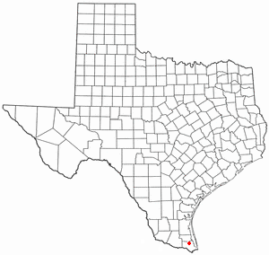
Bayview is a town in Cameron County, Texas, United States. The population was 383 at the 2010 census. It is part of the Brownsville–Harlingen–Raymondville and the Matamoros–Brownsville metropolitan areas.

Combes is a town in northern Cameron County, Texas, United States. Its population was 2,895 at the 2010 census. It is part of the Brownsville–Harlingen–Raymondville and the Matamoros–Brownsville metropolitan areas.

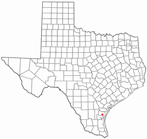
Indian Lake is a town in Cameron County, Texas, United States. The population was 640 at the 2010 census. It may be included as part of the Brownsville–Harlingen–Raymondville and the Matamoros–Brownsville metropolitan areas.
Palm Valley is a city in Cameron County, Texas, United States. The population was 1,304 at the 2010 census. It is part of the Brownsville–Harlingen–Raymondville and the Matamoros–Brownsville metropolitan areas.
Rio Hondo is a city in Cameron County, Texas, United States. The population was 2,356 at the 2010 census. It may be included as part of the Brownsville–Harlingen–Raymondville and the Matamoros–Brownsville metropolitan areas.

Redwood is an unincorporated community and census-designated place (CDP) in Guadalupe County, Texas, United States. The population was 4,003 at the 2020 census, a decline from the figure of 4,338 tabulated in 2010. It is part of the San Antonio Metropolitan Statistical Area.

Edcouch is a city in Hidalgo County, Texas, United States. The population was 3,161 at the 2010 census. It is part of the McAllen–Edinburg–Mission and Reynosa–McAllen metropolitan areas. The town was founded in 1927 and named for Edward Couch, landowner and banker.

Elsa is a city in Hidalgo County, Texas, United States. The population was 7,181 at the 2020 census, It is part of the McAllen–Edinburg–Mission and Reynosa–McAllen metropolitan areas.

Progreso Lakes is a city in Hidalgo County, Texas. The population was 240 at the 2010 United States Census. The city, incorporated in 1979, is centered on Lion and Moon Lakes, two resacas or ox-bow lakes.

Moulton is a town in Lavaca County, Texas, United States. The population was 854 at the 2020 census.

Beverly Hills is a city in McLennan County, Texas, United States. The population was 1,878 at the 2020 census. The city is surrounded by Waco and is part of the Waco Metropolitan Statistical Area.
Petronila is a city in Nueces County, Texas, United States. The population of the city was 89 at the 2020 census.

Uhland is a city in Caldwell and Hays counties in the U.S. state of Texas. The population was 1,588 at the 2020 census, up from 1,014 at the 2010 census. Uhland is named after the German poet Ludwig Uhland. Like its neighbor to the north, the city of Niederwald, Uhland was also settled by German emigrants in the 1800s in a region of central Texas known as the Texas-German belt.