Nkhotakota

Last updated

Nkhotakota
Nkhotakota, Malawi1.jpg
Traditional mud and thatch houses on the beach of Lake Malawi in Nkhotakota
Malawi adm location map.svg
Red pog.svg
Nkhotakota
Location in Malawi
Coordinates: 12°55′00″S34°18′00″E / 12.91667°S 34.30000°E / -12.91667; 34.30000
CountryFlag of Malawi.svg  Malawi
Region Central Region
District Nkhotakota District
Elevation
1,548 ft (472 m)
Population
 (2018 Census [1] )
  Total28,350
  Languages
Chichewa
Time zone +2
Climate Aw

Nkhotakota (Un-kho-tah-kho-tuh) (formerly Kota Kota) (name derived from the Chichewa for "Corner Corner") is a town and one of the districts in the Central Region of Malawi. It is on the shore of Lake Malawi (formerly Lake Nyasa) and is one of the main ports on Lake Malawi. As of 2018, Nkhotakota had a population estimated at 28,350. The district had a population of 301.000.

Contents

History

Nkhotakota was originally a group of villages in the 19th century which later served as a market for Swahili-Arabian slave traders. [2] David Livingstone convinced Chief Jumbe to stop trading slaves under a tree in Nkhotakota in the 19th century, which is currently in existence under a mission. [3] Later Malawi president Hastings Banda gave speeches under another tree in Nkhotakota during the 1960s, this one ironically known as the Livingstone Tree. [3] This town was hit by the 2001 floods, and was the worst hit area of Malawi's Central region. [4] Today, Nkhotakota is the largest traditional African town in Malawi [2] and bears a strong Swahili-Arab influence. [5]

Geography

Mwaya Beach at Nkhotakota Bay on Lake Malawi Mwaya Beach, Malawi.jpg
Mwaya Beach at Nkhotakota Bay on Lake Malawi

Nkhotakota lies at an elevation of 472 metres (1,548 ft) on the shore of Lake Malawi. [2] It is located on a rocky ridge overlooking a natural harbour overlooking Nkhotakota Bay, formed by a sandbar. [2] In addition, Nkhotakota is 200 kilometres (120 mi) from Lilongwe, Malawi's capital, and 378 kilometres (235 mi) from Blantyre, Malawi's largest city. [6]

Wildlife

Nkhotakota is home to the Nkhotakota Wildlife Reserve, where, according to Lonely Planet, one has a good chance of seeing elephants. [7] The reserve is also home to several antelope species, buffalo, and leopards. [8] Several large rivers cross this reserve, the largest in Malawi. [3]

Roughly 24 kilometres (15 mi) south of Nkhotakota is the Chia Lagoon, a large bay linked to Lake Malawi by a narrow channel, crossed by a bridge near Nkhotakota's one major road. [3]

Economy

The biggest formal 'private' employer in the districts is a sugar manufacturing company "Dwangwa Sugar corporation" (currently under Illovo). Most Locals are small holder farmers of Rice, Cassava and maize, while many others are small scale fishermen, who regularly fish along Lake Malawi, Chia Lagoon and many other rivers including Bua, Dwangwa, Dwambazi and Chilua, using triangular nets on poles, hooks, etc.

Another notable antiquity (tourist attraction) in Nkhotakota is the Mawira hot springs, an area of about 3km2 of hot water that continuously gushes from the ground since time immemorial. Mawira hot springs is situated at the central area of the district, 5 km + – from the Ntchisi/Kasungu road junction. [3] Sungu Island (made of sand and rocks) is another fascinating place to visit in Nkhotakota central. This Island is situated inside the Lake Malawi, 1.5 km from the shores, and approximately 2 km from Kaliba station (dock), where passenger boats cruising along the lake Malawi picks or drops passengers and small scale traders.

Climate

Climate data for Nkhotakota (1961–1990)
MonthJanFebMarAprMayJunJulAugSepOctNovDecYear
Mean daily maximum °C (°F)28.5
(83.3)
28.6
(83.5)
28.5
(83.3)
28.0
(82.4)
26.9
(80.4)
25.7
(78.3)
25.4
(77.7)
26.9
(80.4)
29.5
(85.1)
31.8
(89.2)
31.5
(88.7)
29.4
(84.9)
28.4
(83.1)
Daily mean °C (°F)24.3
(75.7)
24.6
(76.3)
24.9
(76.8)
23.8
(74.8)
22.1
(71.8)
20.3
(68.5)
20.0
(68.0)
21.1
(70.0)
23.4
(74.1)
25.9
(78.6)
26.3
(79.3)
25.1
(77.2)
23.5
(74.3)
Mean daily minimum °C (°F)21.1
(70.0)
21.4
(70.5)
20.9
(69.6)
20.1
(68.2)
17.9
(64.2)
15.7
(60.3)
15.3
(59.5)
15.9
(60.6)
18.0
(64.4)
20.8
(69.4)
22.0
(71.6)
21.3
(70.3)
19.2
(66.6)
Average precipitation mm (inches)320.0
(12.60)
266.3
(10.48)
407.6
(16.05)
227.7
(8.96)
33.5
(1.32)
11.5
(0.45)
7.9
(0.31)
2.1
(0.08)
0.7
(0.03)
10.2
(0.40)
79.8
(3.14)
282.0
(11.10)
1,649.3
(64.93)
Average precipitation days (≥ 0.3 mm)20182013432112717108
Average relative humidity (%)83818177726665625958637770
Mean monthly sunshine hours 167.4159.6213.9240.0269.7276.0279.0294.5297.0306.9270.0204.62,978.6
Mean daily sunshine hours 5.45.76.98.08.79.29.09.59.99.99.06.68.2
Source: NOAA [9]

Demographics

Population development

YearPopulation [10] [1]
197710,312
198712,163
199819,262
200824,726
201828,250

Languages

Chichewa is the main language spoken in this town. [11] A Swahili settlement was also established in Nkhotakota. [12] Several Chewa speakers live to the south of Nkhotakota, [13] and Tonga is spoken in its north. [14]

Facilities

Christian cemetery in Nkhotakota Nkhotakota cemetery2.jpg
Christian cemetery in Nkhotakota

Medical

There are two hospitals in Nkhotakota: Nkhotakota District Hospital and St. Anne's Mission Hospital. However, in the whole district there are 23 health facilities including 1 district hospital, 1 mission hospital, 1 government rural hospital, 1 mission rural hospital, 11 health centres, 10 private clinics and 2 dispensaries. [15] [16] In its efforts in the fight against HIV/AIDS, the Society for Women Against AIDS in Malawi (SWAM) implemented a two-year project in Nkhotakota. [17] Nkhotakota is also a regional hub for the [World Medical Fund] – a UK-based medical charity, whose rural outreach services provide the region's villages with basic medical care including anti-retrovirals, anti-malarial treatment and infectious disease management.

Banks

Branches of the First Discount House FDH Bank and NBS Bank are closely located at the central point of the town, on the junction of Salima/Lilongwe and Ntchisi/Kasungu. While Standard Bank (a branch of Standard Bank South Africa) is situated 50 km away at Illovo sugar company's premises in Dwangwa, where National Bank of Malawi and NBS Bank are situated. These commercial Banks provide several banking and other financial services including; foreign currency exchange facilities for local residents and foreign tourists. There are also many Bank agents at the Boma and many trading Centers around the district.

Petrol stations

There are three stations, SIMSO Oil, Mount Meru petroleum and GAM Filling Station at Nkhotakota Boma and others at Dwangwa and Mkaika Trading Center. [3]

Transport

Nkhotakota is one of the main ports on Lake Malawi, [18] and it is served by the ferry MV Ilala that weekly crosses Lake Malawi. The nearest airport is at Kasungu, 77 kilometres (48 mi) away. Buses run from Salima for two hours daily. [19] In addition, minibuses run from here to Nkhata Bay along the main road which connects these towns. [20]

Related Research Articles

<span class="mw-page-title-main">Lilongwe</span> Capital city of Malawi

Lilongwe is the capital and most populated city of the African country of Malawi. It has a population of 989,318 as of the 2018 Census, up from a population of 674,448 in 2008. In 2020 that figure was 1,122,000. The city is located in the central region of Malawi, in the district of the same name, near the borders with Mozambique and Zambia, and it is an important economic and transportation hub for central Malawi. It is named after the Lilongwe River.

Kasungu is a town in the Kasungu District of the Central Region of Malawi. The population of Kasungu was 58,653 according to the 2018 census. Kasungu is approximately 130 kilometres (81 mi) north-west of the capital of Malawi, Lilongwe, and is 35 kilometres (22 mi) east of Kasungu National Park. The main industry in Kasungu is tobacco-growing.

Mchinji is a town and the capital of the Mchinji District in the Central Region of Malawi. Mchinji Boma, located 12 kilometres from the Zambian border and 109 km (68 mi) from the national capital, Lilongwe, is the major hub of government and general business. It has a major railroad junction, being the railhead nearest to Zambia. The area's economy is sustained by rain-fed agriculture.

Balaka is a township in Southern Region, Malawi and headquarters for the Balaka District. The township was formerly a boma of Machinga District, before the Balaka District was created in 1998.

<span class="mw-page-title-main">Monkey Bay</span> Place in Southern Region, Malawi

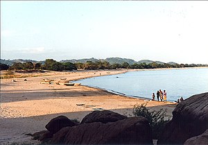
Monkey Bay or Lusumbwe is a town in Mangochi which is in the Mangochi District in the Southern Region of Malawi. The town is on the shore of Lake Malawi and is one of the main ports on Lake Malawi. The population of Monkey Bay was 14,955 according to the 2018 census. Monkey Bay is 206 kilometres (128 mi) from Lilongwe, Malawi's capital city, and 253 kilometres (157 mi) from Blantyre. Monkey Bay is a tourist resort and is often travelled through on the road to Cape Maclear.

<span class="mw-page-title-main">Central Region, Malawi</span> Region of Malawi

The Central Region of Malawi, population 7,523,340 (2018), covers an area of 35,592 km². Its capital city is Lilongwe, which is also the national capital. The region has an outlet on Lake Malawi and borders neighbouring countries Zambia and Mozambique. The Chewa people make up the majority of the population today.

<span class="mw-page-title-main">Ntcheu District</span> District of Malawi

Ntcheu is a district in the Central Region of Malawi. It borders with the country of Mozambique. The district headquarters is Ntcheu, known as BOMA in the local language, but is most commonly called Mphate. It is run by Yeneya, the village headman. The district covers an area of 3,424 km.² and has a population of 659,608 people according to the 2018 Malawi Population and Housing Census. The Ntcheu district lies around halfway between Malawi's majors cities of Blantyre and Lilongwe - the capital city.

Ntchisi is a town located in the Central Region of Malawi. It is the administrative capital of Ntchisi District.

<span class="mw-page-title-main">Nkhata Bay</span> Place in Northern Region, Malawi

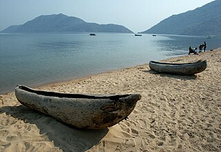
Nkhata Bay or just Nkhata is the capital of the Nkhata Bay District in Malawi. It is on the shore of Lake Malawi, east of Mzuzu, and is one of the main ports on Lake Malawi. The population of Nkhata Bay was 14,274 according to the 2018 census. Nkhata Bay is 413 kilometres (257 mi) from Lilongwe, Malawi's capital city, and 576 kilometres (358 mi) from Blantyre, Malawi's second-largest city. Nkhata Bay is the second "busiest resort" on Lake Malawi.

<span class="mw-page-title-main">Nkhotakota Wildlife Reserve</span>

Nkhotakota Wildlife Reserve, is the largest and oldest wildlife reserve in Malawi, near Nkhotakota. The park's hilly terrain features dambos and miombo woodlands as the dominant vegetation, which support a variety of mammal and bird species. Poaching has greatly reduced the number of elephants and other large mammals in Nkhotakota, but conservation efforts to restore the elephant population started when African Parks began managing the reserve in 2015.

Chintheche is a settlement in the Nkhata Bay District of the Northern Region of Malawi. It is on the shore of Lake Malawi, and is approximately 40 kilometres (25 mi) south of Nkhata Bay. The town is close to the main road between Nkhata Bay and Nkhotakota.

<span class="mw-page-title-main">Cannabis in Malawi</span> Use of cannabis in Malawi

Malawian cannabis, particularly the strain known as Malawi Gold, is internationally renowned as one of the finest sativa strains from Africa. According to a World Bank report it is among "the best and finest" marijuana strains in the world, generally regarded as one of the most potent psychoactive pure African sativas. The popularity of this variety has led to such a profound increase in marijuana tourism and economic profit in Malawi that Malawi Gold is listed as one of the three "Big C's" in Malawian exports: chambo, chombe (tea), and chamba (cannabis).

NBS Bank Limited, commonly referred to as NBS Bank, is a commercial bank in Malawi. It is licensed as a commercial bank, by the Reserve Bank of Malawi, central bank and national banking regulator.

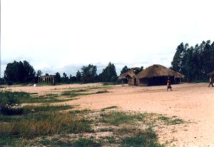
Masitala is a village in central Malawi. It is located in Kasungu District. Its population is about 200. The spoken language is Chichewa.

Burning of charcoal and wood fuel provides approximately 94 percent of the energy in Malawi. Much of the renewable hydroelectric potential of the country is untapped. As per 2018 Population and Housing Census, the national electrification rate in Malawi was 10%, with 37% of the urban population and only 2% of the rural population having access to electricity.

Kanzimbe Solar Power Station, is a 60 megawatts (80,000 hp) solar power plant, in Malawi, in Southern Africa. The power station was constructed between December 2018 and November 2021.

Chipata Mountain is a mountain in central Malawi. It is located in Nkhotakota District, north of the town of Mbobo.

References

  1. 1 2 "2018 Population and Housing Census Main Report" (PDF). Malawi National Statistical Office. Retrieved 25 December 2019.
  2. 1 2 3 4 "Nkhotakota". Encyclopædia Britannica . 2008. Retrieved 27 June 2008.
  3. 1 2 3 4 5 6 Murphy, Alan; Armstrong, Kate; Firestone, Matthew D.; Fitzpatrick, Mary (2007). Lonely Planet Southern Africa: Join the Safari. Lonely Planet. p. 197. ISBN   1-74059-745-1.
  4. "More Rains, Renewed Problems". AllAfrica . 21 March 2001. Retrieved 1 July 2008.
  5. Murphy, p. 159.
  6. "Malawi distance table". Wild Malawi. 2008. Archived from the original on 8 September 2008. Retrieved 20 June 2008.
  7. Murphy, p. 31.
  8. Murphy, p. 166.
  9. "Nkhota Kota Climate Normals 1961–1990". National Oceanic and Atmospheric Administration . Retrieved 10 August 2016.
  10. "Malawi: largest cities and towns and statistics of their population". World Gazetteer. Archived from the original on 27 September 2007. Retrieved 27 June 2008.
  11. Baldauf, Richard B.; Kaplan, Robert (2004). Language Planning and Policy in Africa: Botswana, Malawi, Mozambique and South Africa. p. 85. ISBN   1-85359-725-2.
  12. Baldauf, p. 91.
  13. Baldauf, p. 82.
  14. Baldauf, p. 84.
  15. http://www.nkhotakota.com/health.html~~~~%5B%5D
  16. "Poverty Reduction is Malawi's Priority". AllAfrica . 17 October 2002. Retrieved 2 July 2008.
  17. "SWAM in the Fight Against HIV/Aids". AllAfrica . 7 May 2007. Retrieved 2 July 2008.
  18. "Malawi: Transportation". Encyclopædia Britannica . Retrieved 27 June 2008.
  19. Murphy, p. 176.
  20. Murphy, p. 191.