Normandy, Tennessee

Last updated

Normandy
Normandy, TN - Population 141.jpg
Downtown Normandy
Bedford County Tennessee Incorporated and Unincorporated areas Normandy Highlighted 4753580.svg
Location of Normandy in Bedford County, Tennessee.
Coordinates: 35°27′8″N86°15′31″W / 35.45222°N 86.25861°W / 35.45222; -86.25861
Country United States
State Tennessee
County Bedford
Government
  MayorCharles Whitaker
Area
[1]
  Total0.24 sq mi (0.63 km2)
  Land0.24 sq mi (0.63 km2)
  Water0.00 sq mi (0.00 km2)
Elevation
830 ft (253 m)
Population
 (2020) [2]
  Total108
  Density440.82/sq mi (170.39/km2)
Time zone UTC-6 (Central (CST))
  Summer (DST) UTC-5 (CDT)
ZIP code
37360
Area code 931
FIPS code 47-53580 [3]
GNIS feature ID1295828 [4]

Normandy is a town in Bedford County, Tennessee. The population was 108 at the 2020 census. Normandy Dam is located just northeast of the town. The town is listed on the National Register of Historic Places as the Normandy Historic District. The historic Beech Hall is also located near Normandy.

Contents

History

Normandy was established in 1852 as a railroad town on the old Nashville & Chattanooga Railroad Line later the Nashville, Chattanooga, & St. Louis Railroad. The Normandy lake is also a fishing hot spot in Bedford county.

Geography

Normandy is located at 35°27′8″N86°15′31″W / 35.45222°N 86.25861°W / 35.45222; -86.25861 (35.452249, -86.258714). [5]

According to the United States Census Bureau, the town has a total area of 0.2 square miles (0.52 km2), all of it land and some of it water.

Demographics

Historical population
CensusPop.Note
1880 76
1930 207
1940 163−21.3%
1950 159−2.5%
1960 119−25.2%
1970 1222.5%
1980 118−3.3%
1990 1180.0%
2000 14119.5%
2010 1410.0%
2020 108−23.4%
Sources: [6] [7] [2]

As of the census [3] of 2000, there were 141 people, 53 households, and 35 families residing in the town. The population density was 615.1 inhabitants per square mile (237.5/km2). There were 60 housing units at an average density of 261.7 per square mile (101.0/km2). The racial makeup of the town was 98.58% White, 0.71% Native American, and 0.71% from two or more races. Hispanic or Latino of any race were 0.71% of the population.

There were 53 households, out of which 34.0% had children under the age of 18 living with them, 45.3% were married couples living together, 13.2% had a female householder with no husband present, and 32.1% were non-families. 32.1% of all households were made up of individuals, and 11.3% had someone living alone who was 65 years of age or older. The average household size was 2.66 and the average family size was 3.19.

In the town, the population was spread out, with 27.0% under the age of 18, 13.5% from 18 to 24, 29.8% from 25 to 44, 23.4% from 45 to 64, and 6.4% who were 65 years of age or older. The median age was 34 years. For every 100 females, there were 110.4 males. For every 100 females age 18 and over, there were 98.1 males.

The median income for a household in the town was $40,938, and the median income for a family was $48,125. Males had a median income of $31,429 versus $18,036 for females. The per capita income for the town was $17,729. There were 3.2% of families and 8.8% of the population living below the poverty line, including 18.6% of under eighteens and none of those over 64.

Related Research Articles

<span class="mw-page-title-main">Bedford County, Tennessee</span> County in Tennessee, United States

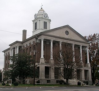
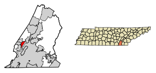
Bedford County is a county located in the U.S. state of Tennessee. As of the 2020 census, the population was 50,237. Its county seat is Shelbyville. Bedford County comprises the Shelbyville, TN Micropolitan Statistical Area, which is also included in the Nashville-Davidson-Murfreesboro, TN Combined Statistical Area.

<span class="mw-page-title-main">Langston, Alabama</span> Town in Alabama, United States

Langston is a town in Jackson County, Alabama, United States, and is included in the Chattanooga-Cleveland-Dalton, TN-GA-AL Combined Statistical Area. In the 2010 census, the population was 270, up from 254. It initially incorporated in 1899. At some point after 1920 it disincorporated, then reincorporated in 1980. Its peak population was 500, in 1920.

<span class="mw-page-title-main">Stevenson, Alabama</span> City in Alabama, United States

Stevenson is a city in Jackson County, Alabama, United States, and is included in the Chattanooga-Cleveland-Dalton, TN-GA-AL Combined Statistical Area. Sources listed either 1866 or 1867 as the year of incorporation, but that seems to conflict with the dates given for the town being granted a charter. It did not first appear on the U.S. Census until 1880, where it was the second largest town in Jackson County behind Scottsboro. Since 1900, it has been the third largest town behind either Scottsboro and Bridgeport or vice versa. At the 2020 census, the population of the city was 1,955, down from 2,046 in 2010.

<span class="mw-page-title-main">Woodville, Alabama</span> Town in Alabama, United States

Woodville is a town in Jackson County, Alabama, United States. It was officially established by an act of the Alabama State Legislature on December 13, 1819, one day before Alabama became a state. It was later incorporated on May 12, 1890, but lost its charter in 1897. It reincorporated in 1912. As of the 2010 census, the population of the town is 746, down from 761 in 2000.

<span class="mw-page-title-main">Parkway–South Sacramento, California</span> Unincorporated community in California, United States

Parkway–South Sacramento is a former census-designated place (CDP) in Sacramento County, California, United States. It is part of the Sacramento–Arden-Arcade–Roseville Metropolitan Statistical Area. The area shares three boundaries with the City of Sacramento. The population was 36,468 at the 2000 census.

<span class="mw-page-title-main">Placid Lakes, Florida</span> Unincorporated community in Florida, United States

Placid Lakes is an unincorporated community in Highlands County, Florida, United States. The population was 3,054 according to the 2000 census, at which time it was a census-designated place (CDP). Placid Lakes is a predominantly residential community southwest of the town of Lake Placid and due south of Lake June.

<span class="mw-page-title-main">Hudson, Iowa</span> City in Iowa, United States

Hudson is a city in Black Hawk County, Iowa, United States. The population was 2,546 at the time of the 2020 census. The rural community of Hudson has grown in recent years and is included as a part of the Waterloo-Cedar Falls Metropolitan Statistical Area.

Juniata Township is a civil township of Tuscola County in the U.S. state of Michigan. The population was 1,567 at the 2010 Census.

<span class="mw-page-title-main">Seaboard, North Carolina</span> Town in North Carolina, United States

Seaboard is a township in Northampton County, North Carolina, United States, created as a company town by the Seaboard and Roanoke Railroad, approximately 10 miles northeast of Weldon in the mid-1840s as a place for railroad employees to live.

<span class="mw-page-title-main">Dante, South Dakota</span> Town in South Dakota, United States

Dante is a town in Charles Mix County, South Dakota, United States. The population was 75 at the 2020 census.

<span class="mw-page-title-main">Bell Buckle, Tennessee</span> Town in Tennessee, United States

Bell Buckle is a town in Bedford County, Tennessee, United States. The population was 410 at the 2020 census. The downtown area is listed on the National Register of Historic Places as the Bell Buckle Historic District.

<span class="mw-page-title-main">Wartrace, Tennessee</span> Town in Tennessee, United States

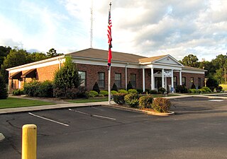
Wartrace is a town in Bedford County, Tennessee. The population was 653 at the 2020 census. It is located northeast of Shelbyville. The downtown area is listed on the National Register of Historic Places as the Wartrace Historic District.

<span class="mw-page-title-main">Cowan, Tennessee</span> City in Tennessee, United States

Cowan is a city in Franklin County, Tennessee, United States. The population was 1,737 at the 2010 census. It is part of the Tullahoma, Tennessee Micropolitan Statistical Area.

<span class="mw-page-title-main">Decherd, Tennessee</span> City in Tennessee, United States

Decherd is a city in Franklin County, Tennessee, United States. The population was 2,379 at the 2020 census and 2,361 at the 2010 census.

<span class="mw-page-title-main">Soddy-Daisy, Tennessee</span> City in Tennessee, United States

Soddy-Daisy is a city in Hamilton County, Tennessee, United States. The population was 13,070 at the 2020 census and estimated to be 13,619 in 2022. The city was formed in 1969 when the communities of Soddy and Daisy, along with nearby developed areas along U.S. Highway 27, merged to form Soddy-Daisy. It is becoming a bedroom community of nearby Chattanooga and is part of the Chattanooga Metropolitan Statistical Area. Sequoyah Nuclear Generating Station is located in Soddy-Daisy.

<span class="mw-page-title-main">Walden, Tennessee</span> Town in Tennessee, United States

Walden is a town located in Hamilton County, Tennessee, United States. The population was 1,981 at the 2020 census and up from 1,898 at the 2010 census. It is part of the Chattanooga, Tennessee–Georgia Metropolitan Statistical Area.

<span class="mw-page-title-main">Kimball, Tennessee</span> Town in Tennessee, United States

Kimball is a town in Marion County, Tennessee, United States. The population was 1,545 at the 2020 census and 1,395 in 2010. It is part of the Chattanooga, TN–GA Metropolitan Statistical Area.

<span class="mw-page-title-main">Cecil, Wisconsin</span> Village in Wisconsin, United States

Cecil is a village in Shawano County, Wisconsin, United States. The population was 570 at the 2010 census.

<span class="mw-page-title-main">Bedford (CDP), New York</span> Census-designated place in New York, United States

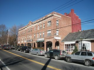
Bedford is a hamlet and census-designated place (CDP) located in the town of Bedford in Westchester County, New York, United States. The population was 1,834 at the 2010 census.

<span class="mw-page-title-main">Groton (CDP), Massachusetts</span> Census-designated place in Massachusetts, United States

Groton is a census-designated place (CDP) comprising the main village in the town of Groton in Middlesex County, Massachusetts, United States. The population of the CDP was 1,353 at the 2020 census, out of 11,315 in the entire town of Groton.

References

  1. "ArcGIS REST Services Directory". United States Census Bureau. Retrieved October 15, 2022.
  2. 1 2 "Census Population API". United States Census Bureau. Retrieved October 15, 2022.
  3. 1 2 "U.S. Census website". United States Census Bureau . Retrieved January 31, 2008.
  4. "US Board on Geographic Names". United States Geological Survey. October 25, 2007. Retrieved January 31, 2008.
  5. "US Gazetteer files: 2010, 2000, and 1990". United States Census Bureau. February 12, 2011. Retrieved April 23, 2011.
  6. "Census of Population and Housing: Decennial Censuses". United States Census Bureau . Retrieved March 4, 2012.
  7. "Incorporated Places and Minor Civil Divisions Datasets: Subcounty Resident Population Estimates: April 1, 2010 to July 1, 2012". Population Estimates. U.S. Census Bureau. Archived from the original on June 11, 2013. Retrieved December 11, 2013.