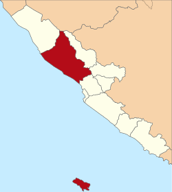
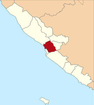
Pesisir Selatan Regency is a regency (kabupaten) of West Sumatra Province of Indonesia. It has an area of 6,049.33 km² and a population of 429,246 at the 2010 Census and 504,418 at the 2020 Census; the official estimate as at mid-2023 was 525,355. The regency seat is at the town of Painan, in IV Jurai District.

Rejang Lebong is a regency of Bengkulu Province, Indonesia, on the island of Sumatra. This regency originally included a much larger part of the inland district of the province, but on 25 February 2003 it was divided in three, with districts in the northwest being split off to form a separate Lebong Regency, and districts in the south being similarly split off to form a new Kepahiang Regency. The residual Rejang Lebong Regency now covers 1,550.28 km² and had a population of 246,787 at the 2010 Census and 276,645 at the 2020 Census; the official estimate as at mid 2022 was 281,281. The administrative centre of the Rejang Lebong Regency is the town of Curup. The Rejangese people are the most numerous ethnic group in Bengkulu Province, and inhabit the western half of the Regency, while the Lembak people inhabit the eastern half.

South Bengkulu is a regency of Bengkulu Province, Indonesia, on the island of Sumatra. It originally comprised all of that part of Bengkulu Province situated to the southeast of the city of Bengkulu, but on 25 February 2003 this area was split into three parts, with the most southeastern districts split off to form a new Kaur Regency and the most northwestern districts split off to form a new Seluma Regency. The reduced South Bengkulu Regency now covers 1,219.91 km2, and had a population of 142,940 at the 2010 Census and 166,249 at the 2020 Census; the official estimate as at mid 2023 was 171,463 - comprising 87,297 males and 84,166 females. The regency's administrative centre is the coastal town of Manna.

West Kutai Regency is a regency (kabupaten) in the Indonesian province of East Kalimantan. It previously covered a much greater area, with a population of 165,091 at the 2010 Census, but on 11 January 2013 the five northernmost districts were split off to form a new Mahakam Ulu Regency; the residual area of West Kutai Regency is 20,384.6 km2, and it had a population of 140,097 at the 2010 Census, and 165,938 at the 2020 Census; the official estimate as at mid 2023 was 177,007. The town of Sendawar is the administrative capital.
Central Bengkulu Regency is a regency of Bengkulu Province, Indonesia. It is located on the west coast of the island of Sumatra, and lies immediately to the north and the east of the adjacent city of Bengkulu. It was formed on 24 June 2008 by being split away from the neighbouring North Bengkulu Regency. It covers an area of 1,223.94 km2 and had a population of 98,333 at the 2010 census and 116,706 at the 2020 census; the official estimate as at mid 2023 was 121,139 - comprising 62,078 males and 59,061 females. the administrative centre is at the town of Karang Tinggi.

Labuhanbatu Regency, alternatively written in space as Labuhan Batu Regency, is a regency of North Sumatra Province in Indonesia. Its administrative seat is Rantau Prapat. An original regency of the province, it had an area of 9,703 km2 as at early 2008, prior to the separation out of its southern and its north-western districts respectively to create the new South Labuhanbatu and North Labuhanbatu Regencies on 21 July 2008.

Langkat Regency is the northernmost regency of North Sumatra Province in Indonesia. Its administrative centre is the town of Stabat. It has a land area of 6,263.29 km2 and its population was 967,535 at the 2010 Census and 1,030,202 at the 2020 Census; the official estimate as at mid 2023 was 1,066,711 - comprising 538,822 males and 527,889 females.

Samosir Regency is an inland regency in North Sumatra. It was created on 18 December 2003 by splitting away the western districts of the former Toba Samosir Regency. The regency covers a land area of 1,444.25 square kilometres, including the whole of Samosir Island in the inland sea of Lake Toba. It had a population of 119,653 at the 2010 census and 136,441 at the 2020 Census; the official estimate for mid 2023 was 141,333 - comprising 70,648 males and 70,685 females. Its administrative seat is the town of Pangururan on the west coast of Samosir Island.

North Tapanuli Regency is a landlocked regency in North Sumatra province, Sumatra, Indonesia. Its capital is Tarutung. The regency covers an area of 3,793.71 square kilometres and it had a population of 278,897 at the 2010 Census and 312,758 at the 2020 Census; the official estimate as of mid-2023 was 323,102.
Mamuju Regency is a regency of West Sulawesi province, Indonesia. The regency capital is at Karema, while Mamuju town is the capital of West Sulawesi. The population of the regency was 336,879 at the 2010 Census, but it was substantially reduced by the creation of the new Central Mamuju Regency which was cut out of it on 14 December 2012. The reduced Mamuju Regency covers an area of 4,979.89 km2 and had a population of 278,764 at the 2020 Census; the official estimate as at mid 2023 was 292,395.
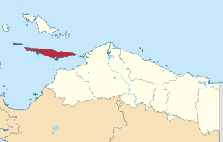
Yapen Islands Regency is a regency (kabupaten) in Papua Province of eastern Indonesia. It covers an area of 2,432.49 km2 (939.19 sq mi), and had a population of 82,951 at the 2010 Census and 112,676 at the 2020 Census; the official estimate as at mid 2022 was 116,107. It comprises an archipelago which lies in Cenderawasih Bay off the north coast of Western New Guinea.

Manggarai Regency is a regency in East Nusa Tenggara province of Indonesia, situated on the island of Flores. Established in 1958 the regency was reduced in size and population by the separation of the more western districts to form West Manggarai Regency in 2003 and of the more eastern districts to form East Manggarai Regency in 2007. The area of the residual Manggarai Regency is 1,343.83 km2 and its population was 292,037 at the 2010 census and 312,855 at the 2020 census; the official estimate as at mid 2023 was 328,758. The capital of the regency is the town of Ruteng.

Sitaro Islands Regency is a regency located off the northern extremity of Sulawesi Island in the southern Sangihe Islands, North Sulawesi Province, Indonesia. The regency was formed under Law Number 15 Year 2007 from 2 January 2007, by separation from the Sangihe Islands Regency of which it had previously formed the southern part. The short form of the name is formed from one syllable from each of the names of the three principal islands — Siau, Tagulandang and Biaro.

Paser Regency is the southernmost regency (kabupaten) within the East Kalimantan province of Indonesia. It was created in 1959, originally spelt "Pasir Regency", but renamed "Paser" in 2007; however its northeastern districts were split off on 10 April 2002 to form the new Penajam North Paser Regency. The residual regency covers an area of 11,603.94 km2, and it had a population of 230,316 at the 2010 Census and 275,452 at the 2020 Census; the official estimate as at mid-2023 was 303,424. Its administrative centre is the town of Tana Paser.

Meranti Islands is an archipelago forming a regency (kabupaten) of Riau Province and lies off the eastern coast of the island of Sumatra, Indonesia. It was created on 19 December 2008 by the separating of this archipelago from the mainland regency of Bengkalis. The regency comprises the islands of Tebing Tinggi, Rangsang, Padang, and Merbau, together with minor offshore islands, but does not include Bengkalis Island which is geographically part of the archipelago but remains within Bengkalis Regency. The principal town is Selat Panjang on Tebing Tinggi Island. The regency covers an area of 3,623.93 km2 and had a population of 176,290 at the 2010 Census and 206,116 at the 2020 Census; the official estimate as of mid-2022 was 213,532.

Kaur is the most southern regency of Bengkulu Province, Indonesia, on the west coast of the island of Sumatra. It was created on 25 February 2003 from what were formerly the southeastern districts of the South Bengkulu Regency. It has an area of 2,365.00 km2 and had a population of 107,899 at the 2010 Census and 126,551 at the 2020 Census; the official estimate as at mid 2023 was 131,063 - comprising 67,389 males and 63,674 females. The regency seat is at the town of Bintuhan.

Lebong is an inland regency of Bengkulu Province, Indonesia, on the island of Sumatra. It covers an area of 1,665.28 km2, and had a population of 97,091 at the 2010 Census and 106,293 at the 2020 Census; the official estimate as at mid 2022 was 107,248. Contrary to the popularly-held belief that the town of Muara Aman is the seat of the government of Lebong Regency, the regency's capital is actually located in neighboring Tubei district, where all the office and judiciary institution is situated. Until 1966 the regency, together with the rest of what is now Bengkulu Province, was part of South Sumatra Province. It formed part of Rejang Lebong Regency until 25 February 2003, when the northwestern districts of that regency were split off to create the new Lebong Regency.

Seluma Regency is a regency of Bengkulu Province, Indonesia, on the west coast of the island of Sumatra. It was created on 25 February 2003 from what were formerly the northwestern districts of the South Bengkulu Regency. The regency seat is at the town of Pasar Tais. It covers an area of 2,479.36 km2, and had a population of 173,507 at the 2010 Census and 207,877 at the 2020 Census; the official estimate as at mid 2023 was 215,063.

South Lampung Regency is a regency of Lampung, Sumatra, Indonesia, a strip of land surrounding the provincial capital of Bandar Lampung on its northern and eastern sides, and bounded to the west by the new Pesawaran Regency and to the south by the Sunda Strait; as such it is a major transit corridor to/from Java island. It has an area of 2,109.74 km2, and a population of 909,989 at the 2010 census and 1,064,301 at the 2020 census; the official estimate as at mid 2023 was 1,101,376. The regency seat is the town of Kalianda.

Tanggamus Regency is a regency (kabupaten) of Lampung Province, Sumatra, Indonesia. It has an area of 4,654.96 km2 which consists of a land area of 2,855.46 km2 and a sea area of 1,799.5 km2. It had a population of 534,595 at the 2010 Census and 640,275 at the 2020 Census; the official estimate as at mid 2023 was 662,542. The regency seat is the town of Kota Agung Pusat. The regency was created on 21 March 1997 from what were previously the western districts of South Lampung Regency, but districts in its eastern part split away on 29 October 2008 to form the new Pringsewu Regency. It lies in the southwest of the province, and surrounds Semangka Bay on its west, north and east coasts.