
U.S. Route 321 (US 321) is a spur of U.S. Route 21. It runs for 516.9 miles (831.9 km) from Hardeeville, South Carolina to Lenoir City, Tennessee; with both serving as southern termini. It reaches its northernmost point at Elizabethton, Tennessee. Because of its unusual "north–south–north" routing, U.S. Route 321 intersects both Interstate 40 and U.S. Route 70 three separate times. The highway serves different roles in each state: An alternate route to interstates in South Carolina, a major highway in North Carolina, and a scenic route in Tennessee.
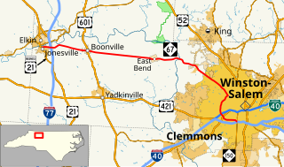
North Carolina Highway 67 (NC 67) is a 40.9-mile-long (65.8 km) primary state highway in the U.S. state of North Carolina. It serves mostly the northern area of Yadkin County, connecting the towns of Jonesville, Boonville and East Bend, along with the city of Winston-Salem in Forsyth County.

North Carolina Highway 16 (NC 16) is a primary state highway in the U.S. state of North Carolina. Traveling north–south, it connects the cities of Charlotte, Conover, Taylorsville, Wilkesboro and Jefferson; linking the Charlotte metropolitan area with the High Country. NC 16 is part of a three-state route 16 that connects the Charlotte region with northwestern West Virginia.
North Carolina Highway 150 (NC 150) is a primary state highway in the U.S. state of North Carolina. It serves the Foothills and Piedmont Triad areas of the state, connecting the cities of Shelby, Mooresville, Salisbury and Winston-Salem.
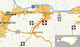
North Carolina Highway 110 (NC 110) is a 5.51-mile-long (8.87 km) primary state highway in the U.S. state of North Carolina. The route serves to connect the rural communities of Cruso, Woodrow, and Bethel with the town of Canton entirely in Haywood County

North Carolina Highway 55 (NC 55) is a primary state highway in the U.S. state of North Carolina. It serves as a traffic artery connecting Durham with Cary and numerous small cities and towns in The Triangle on its way toward the Pamlico Sound. A portion of NC 55 extends through Research Triangle Park. NC 55 is a major artery in the central part of The Triangle region, and is a four lane, divided highway between Durham and Cary and Apex. NC 55 is also a divided highway between Apex and Fuquay-Varina.
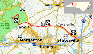
North Carolina Highway 90 is a primary state highway in the U.S. state of North Carolina. It is one of the few highways in the state with an unpaved portion.
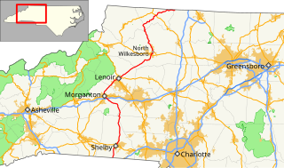
North Carolina Highway 18 (NC 18) is a primary state highway in the U.S. state of North Carolina. Traveling north–south through the Foothills region, it connects the cities of Shelby, Morganton, Lenoir, Wilkesboro and North Wilkesboro.

North Carolina Highway 22 is a North Carolina state highway that runs in the central-north part of the state. It runs between Southern Pines and Climax. The route is signed north–south, and is 59 miles (95 km) in length.

North Carolina Highway 27 (NC 27) is a primary state highway in the U.S. state of North Carolina. The route traverses 198 miles (319 km) through southern and central North Carolina, about 100 miles (160 km) of it as a concurrency with NC 24.

North Carolina Highway 60 (NC 60) is a primary state highway in the extreme southwestern corner of North Carolina. The highway runs north–south from the Georgia state line to U.S. Route 64/U.S. Route 74 (US 64/US 74), near Ranger.

North Carolina Highway 62 (NC 62) is a primary state highway in the U.S. state of North Carolina. Primarily in the Piedmont Triad, it runs from NC 109 in Thomasville northeast to the Virginia state line in Milton.
North Carolina Highway 68 (NC 68) is a north–south state highway in North Carolina. It serves as a connector between Interstate 40 (I-40)/ U.S. Route 421 (US 421) and Piedmont Triad International Airport. On its routing from Thomasville to Stokesdale, NC 68 passes through urban High Point, the western outskirts of Greensboro, and the town of Oak Ridge. The segment from just north of the I-40/US 421 interchange to Pleasant Ridge Road in Guilford County is a limited access freeway.

North Carolina Highway 268 (NC 268) is a primary state highway in the U.S. state of North Carolina. It connects many communities as it traverses through the northwestern North Carolina mountains and foothills.
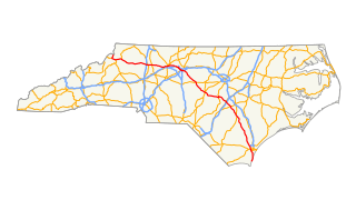
U.S. Route 421 (US 421) traverses approximately 328 miles (528 km) across North Carolina; from Fort Fisher, on Pleasure Island between the Atlantic Ocean and Cape Fear River, to the Tennessee state line near the community of Zionville. The highway is labeled "north" and "south" throughout North Carolina, it follows a northwest-southeast path. The segments from Buies Creek to Sanford and from Greensboro to Boone are mostly a west-east route.
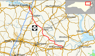
North Carolina Highway 125 (NC 125) is a primary state highway in the U.S. state of North Carolina that serves the communities of Williamston, Hamilton, Oak City, Hobgood, Scotland Neck, Halifax, and Roanoke Rapids.
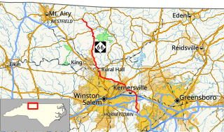
North Carolina Highway 66 (NC 66) is a 47.4-mile (76.3 km) North Carolina state highway that travels from Horneytown to Johnstown, connecting the towns and communities of eastern Forsyth and Stokes counties.

North Carolina Highway 217 (NC 217) is a primary state highway in the U.S. state of North Carolina. The highway connects the town of Linden to nearby Erwin to Fayetteville.
Several special routes of U.S. Route 421 exist. In order from south to north they are as follows.

North Carolina Highway 901 (NC 901) is a primary state highway in the U.S. state of North Carolina. The highway serves to connect the town of Harmony with nearby major highways.

