Blasdell is a village in Erie County, New York, United States. The population was 2,553 according to the 2010 Census. The name is derived from Herman Blasdell, the first station master of the Erie and Pennsylvania railroad depot. It is part of the Buffalo–Niagara Falls Metropolitan Statistical Area.

Niagara Falls is a city in Niagara County, New York, United States. As of the 2020 census, the city had a total population of 48,671. It is adjacent to the Niagara River, across from the city of Niagara Falls, Ontario, and named after the famed Niagara Falls which they share. The city is within the Buffalo–Niagara Falls metropolitan area and the Western New York region.

Tonawanda is a city in Erie County, New York, United States. The population was 15,129 at the 2020 census. It is at the northern edge of Erie County, south across the Erie Canal from North Tonawanda, east of Grand Island, and north of Buffalo. It is part of the Buffalo-Niagara Falls metropolitan area.

Lockport is a town in Niagara County, New York, United States. The population was 20,529 at the 2010 census. The name is derived from the series of canal locks on the Erie Canal. The locks lift boats from the lowland of Lake Ontario past the Niagara Escarpment.
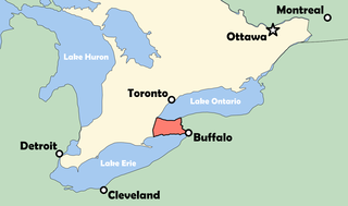
The Niagara Peninsula is an area of land lying between the southwestern shore of Lake Ontario and the northeastern shore of Lake Erie, in Ontario, Canada. Technically an isthmus rather than a peninsula, it stretches from the Niagara River in the east to Hamilton, Ontario, in the west. The peninsula is located in the Golden Horseshoe region of Southern Ontario, and has a population of roughly 1,000,000 residents. The region directly across the Niagara River and Lake Erie in New York State is known as the Niagara Frontier.

West Town, northwest of the Loop on Chicago's West Side, is one of the city's officially designated community areas. Much of this area was historically part of Polish Downtown, along Western Avenue, which was then the city's western boundary. West Town was a collection of several distinct neighborhoods and the most populous community area until it was surpassed by Near West Side in the 1960s. The boundaries of the community area are the Chicago River to the east, the Union Pacific railroad tracks to the south, the former railroad tracks on Bloomingdale Avenue to the North, and an irregular western border to the west that includes the city park called Humboldt Park. Humboldt Park is also the name of the community area to West Town's west, Logan Square is to the north, Near North Side to the east, and Near West Side to the south. The collection of neighborhoods in West Town along with the neighborhoods of Bucktown and the eastern portion of Logan Square have been referred to by some media as the "Near Northwest Side".

Broadway is a neighborhood within the city of Newark in Essex County, in the U.S. state of New Jersey. It is located on the west bank of the Passaic River, in Newark's North Ward, east of Forest Hill and north of Seventh Avenue. The neighborhood extends from Interstate 280 to Belleville. The term "Broadway" has only come into use recently, most Broadway residents simply refer to their area as part of the North Ward. The street itself "Broadway" was called "Washington Avenue" until the early twentieth century. Today, the area is predominantly Italian American, Puerto Rican and Dominican, with a growing population from other parts of Latin America. The New Jersey Historical Society was located here from the 1930s to 1997. The neo-classical Mutual Benefit building was constructed in the Broadway neighborhood in 1927. The district has many old brownstones in various states of repair. There are high-rise apartment buildings overlooking Branch Brook Park.
Lawncrest is a neighborhood in the "Near" (lower) Northeast Philadelphia, Pennsylvania. The name is an amalgam of Lawndale and Crescentville, the two primary communities that make up the neighborhood. The Philadelphia Inquirer does not consider Lawncrest to be a neighborhood.

Seneca Niagara Casino & Hotel is a casino in Niagara Falls, New York, United States. It was built by the Seneca Nation to compete with Casino Niagara and Niagara Fallsview Casino Resort in Niagara Falls, Ontario, Canada. Formerly known as the Niagara Falls Convention and Civic Center, it was sold to the federally recognized Seneca Nation of New York.

Highland Park is a neighborhood comprising several historic districts north of downtown Richmond, Virginia. Over time, various boundaries have served to split the neighborhood into sections traditionally labeled East Highland Park, North Highland Park, and South Highland Park. The southern Highland Park boundaries are roughly First Avenue to the west, Fifth Avenue to the east, the Shockoe Valley to the south, and E. Brookland Park Boulevard to the north. The Highland Park Southern Tip neighborhood is also known as the Chestnut Hill-Plateau Historic District. The Highland Park Plaza/Northern Highland Park boundaries are roughly defined by Pensacola ave and the railroad tracks to the north, Fifth avenue to the east, E. Brookland Park boulevard to the south, and Meadowbridge Road to the west. The zip code is 23222.

The Railroad Museum of the Niagara Frontier is located in the 1922-built Erie Railroad freight depot in North Tonawanda, New York. Operated by the Niagara Frontier Chapter of the National Railroad Historical Society, its mission is to preserve the railroad history of the Buffalo, New York area, once the railroad hub of America. The Museum is owned by the Niagara Frontier Chapter of the National Railway Historical Society.

New York State Route 61 (NY 61) is a state highway located almost entirely in the city of Niagara Falls in Niagara County, New York, in the United States. The road runs across the city in a northwest–southeast direction, terminating at NY 384 at its southern extent and NY 104 at its northern tip. Conceptually, the road, known as Hyde Park Boulevard, forms the eastern border of downtown Niagara Falls. It is the second-shortest two-digit route in New York after NY 71 in Columbia County. The NY 61 designation was in 1958 after being approved by the Niagara Falls City Council.

The neighborhoods of Milwaukee include a number of areas in southeastern Wisconsin within the state's largest city at nearly 600,000 residents.
Columbus, the state capital and Ohio's largest city, has numerous neighborhoods within its city limits. Neighborhood names and boundaries are not officially defined. They may vary or change from time to time due to demographic and economic variables.
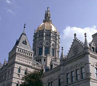
The neighborhoods of Hartford, Connecticut in the United States are varied and historic.
The Black Rock Rail Yard is on the west side of Buffalo, New York, a half mile inland from the Niagara River, in the Black Rock neighborhood. The rail yard receives Canadian National Railway freight trains arriving from Canada by way of the International Railway Bridge.
The Lovejoy District is a neighborhood in Buffalo, New York. Lovejoy is the easternmost portion of the city, running along the city's border with Cheektowaga. The councilman of the area in 2017 is Richard Fontana.
Many Neighborhoods of Toledo, Ohio are of historic interest.