While the city was formerly inhabited by Native Americans, Europeans who migrated to the Niagara Falls in the mid-17th century began to open businesses and develop infrastructure. Later in the 18th and 19th centuries, scientists and businessmen began harnessing the power of the Niagara River for electricity and the city began to attract manufacturers and other businesses drawn by the promise of inexpensive hydroelectric power. After the 1960s, however, the city and region experienced an economic decline. As industries left the region, affluent and middle-class families relocated from Niagara Falls to other metropolitan areas around the country.
Due to the loss of jobs in the region, especially in the manufacturing sector, the city has gone from over 102,000 residents in 1960 to approximately 48,000 residents in 2020, a population drop of more than 50%.
History
Before Europeans entered the area, it was dominated by the Neutral Nation of Native Americans. European migration into the area began in the 17th century. The first recorded European to visit the area was FrenchmanRobert de la Salle, who built Fort Conti at the mouth of the Niagara River early in 1679, with permission from the Iroquois, as a base for boatbuilding; his ship Le Griffon was built on the upper Niagara River at or near Cayuga Creek in the same year.[3] He was accompanied by Belgian priest Louis Hennepin, who was the first known European to see the falls. The influx of newcomers may have been a catalyst for already hostile native tribes to turn to open warfare in competition for the fur trade.
By the end of the 19th century, the city was heavily industrialized, due in part to the power potential offered by the Niagara River. Tourism was considered a secondary niche, while manufacturing of petrochemicals, abrasives, metallurgical products and other materials was the main producer of jobs and attracted a large number of workers, many of whom were immigrants.
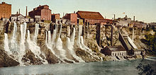
The Niagara Falls mill district downriver from the American Falls, 1900
In 1927, the city annexed the village of La Salle, named for Robert de la Salle, from the Town of Niagara.
Industry and tourism grew steadily throughout the first half of the 20th century due to a high demand for industrial products and the increased mobility of people to travel. Paper, rubber, plastics, petrochemicals, carbon insulators and abrasives were among the city's major industries. This prosperity would end by the late 1960s as aging industrial plants moved to less expensive locations. In addition, the falls were incompatible with modern shipping technology.[further explanation needed]
In 1956, the Schoellkopf Power Plant on the lower river just downstream of the American Falls was critically damaged by the collapse of the Niagara Gorge wall above it. This prompted the planning and construction of one of the largest hydroelectric plants to be built in North America to that time, generating a large influx of workers and families to the area. New York City urban planner Robert Moses built the new power plant in nearby Lewiston, New York. Much of the power generated there fueled growing demands for power in downstate New York and New York City.
The neighborhood of Love Canal gained national media attention in 1978 when toxic waste contamination from a chemical landfill beneath it forced United States President Jimmy Carter to declare a state of emergency, the first such presidential declaration made for a non-natural disaster. Hundreds of residents were evacuated from the area, many of whom were ill because of exposure to chemical waste.[5]
The contaminated neighborhood of Love Canal received national attention in 1978.
After the Love Canal disaster, the city—which had already been declining in population for nearly two decades—experienced accelerated economic and political difficulties. The costs of manufacturing elsewhere had become less expensive, which led to the closure of several factories. The city's population eventually dropped by more than half of its peak, as workers fled the city in search of jobs elsewhere. Then, much like the nearby city of Buffalo, the city's economy plummeted when a failed urban renewal project destroyed Falls Street and the tourist district.
In 2001, the leadership of Laborers Local 91 was found guilty of extortion, racketeering and other crimes following an exposé by Mike Hudson of the Niagara Falls Reporter. Union boss Michael "Butch" Quarcini died before trial, while the rest of the union leadership was sentenced to prison.
In early 2010, former Niagara Falls Mayor Vincenzo Anello was indicted on federal charges of corruption, alleging the mayor accepted $40,000 in loans from a businessman who was later awarded a no-bid lease on city property. The charges were dropped as part of a plea deal after Anello pleaded guilty to unrelated charges of pension fraud, regarding a pension from the International Brotherhood of Electrical Workers, of which he is a member. He was sentenced to 10 to 16 months in prison.[6]
On November 30, 2010, the New York State Attorney General entered into an agreement with the city and its police department to create new policies to govern police practices in response to claims of excessive force and police misconduct. The city committed to create policies and procedures to prevent and respond to allegations of excessive force, and to ensure police are properly trained and complaints are properly investigated. Prior claims filed by residents will be evaluated by an independent panel.[8]
Cataract Commons
In 2020, a public square named Cataract Commons opened on Old Falls Street. It is a public space for outdoor events and activities.[9][10]
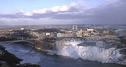
According to the United States Census Bureau, the city has an area of 16.8 square miles (44km2), of which 14.1 square miles (37km2) is land and 2.8 square miles (7.3km2) (16.37%) is water.[13] The city is built along the Niagara Falls and the Niagara Gorge, which is next to the Niagara River.
Climate
Niagara Falls has a humid continental climate (Dfa). The city experiences cold, snowy winters and hot, humid summers. Precipitation is moderate and consistent in all seasons, falling equally or more as snow during the winter. The city has snowier than average winters compared to most cities in the US, however less than many other cities in Upstate New York including nearby Buffalo and Rochester. Thaw cycles with temperatures above 32°F (0°C) are a common occurrence.[14] The hottest and coldest temperatures recorded in the decade through 2015 were 97°F (36°C) in 2005 and −13°F (−25°C) in 2003, respectively.[15] 38% of warm season precipitation falls in the form of a thunderstorm.[16]
Buffalo Avenue – runs along the south end along the Niagara River once home to a vast number of old families with architecturally significant mansions; further east (past John Daly Boulevard) the street is surrounded by a number of industrial sites to 56th Street before returning to a residential area and ending at the Love Canal area at 102nd Street.
Deveaux – Located in the northwestern corner (west of the North End) along the Niagara River is residential area built in the 1920s to 1940s. Named for Judge Samuel DeVeaux who left his estate to be established as the Deveaux College for Orphans and Destitute Children in 1853 (closed 1971), now the site of DeVeaux Woods State Park[20] and DeVeaux School Historical District.
East Side – the area bounded by the gorge on the west, Niagara Street on the south, Ontario Avenue on the North and Main Street (NY Rt 104) on the east.[21]
Hyde Park – Located near the namesake Hyde Park next to Little Italy as well as home to Hyde Park Municipal Golf Course.[22]
LaSalle – Bounded by 80th Street, Niagara Falls Boulevard, Cayuga Drive and LaSalle Expressway was built up in the 1940s to 1960s. Cayuga Island is linked to neighborhood. The actual neighborhood where the Love Canal was to be built.[23]
Little Italy – home to a once predominately Italian community that runs along Pine Avenue from Main Street to Hyde Park Boulevard
Love Canal – Established in the 1950s on land acquired from Hooker Chemical Company. Most of the neighborhood was evacuated in the 1980s after toxic waste was discovered underground. Resettlement began in 1990.[24]
Niagara Street – residential area east of Downtown along Niagara Street (distinct from Niagara Ave.) once home to a predominately German and Polish community.
North End – runs along Highland Avenue in the north end of the city before it merges with Hyde Park Boulevard.
As of the census of 2010, there were 50,193 people, 22,603 households, and 12,495 families residing in the city. The population density was 2,987.7 people per square mile (1,153.5 per square km). There were 26,220 housing units at an average density of 1,560.7 per square mile (602.6/km2). The racial makeup of the city was 70.5% White, 21.6% African American, 1.9% Native American, 1.2% Asian, 0% Pacific Islander, 0.8% from other races, and 3.9% from two or more races. Hispanic or Latino of any race were 3.0% of the population.
There were 22,603 households, out of which 23.9% had children under the age of 18 living with them, 29.8% were married couples living together, 19.7% had a female householder with no husband present, and 44.7% were non-families. 38.1% of all households were made up of individuals, and 13.7% had someone living alone who was 65 years of age or older. The average household size was 2.20 and the average family size was 4.02.
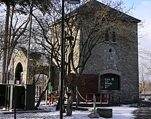
St. Peter's Episcopal Church
In the city, 22% of the population was under the age of 18, 10.1% aged from 18 to 24, 24.2% from 25 to 44, 28.2% from 45 to 64, and 15.5% were 65 years of age or older. The median age was 39 years. For every 100 females, there were 91.2 males. For every 100 females age 18 and over, there were 94.4 males.
The median income for a household in the city was $26,800, and the median income for a family was $34,377. Males had a median income of $31,672 versus $22,124 for females. 23% of the population was below the poverty line.
Niagara Falls has struggled with high rates of violent and property crime; FBI crime data indicate that the city has among the highest crime rates in New York state.[26][27] In response to gun violence, volunteer groups such as Operation SNUG mobilized to promote positive community involvement in the troubled areas of the city.[28]
Economy
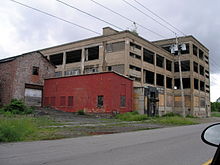
Abandoned industrial building within "Chemical Row" in Niagara Falls
Niagara Falls' main industry is tourism, driven primarily by the waterfalls.[29]
A 2012 profile from the Office of the New York State Comptroller reported that Niagara Falls has "struggled through decades of population losses, rising crime and repeated attempts to reinvent itself from a manufacturing town with some tourism to a major tourist destination."[30] The city became a boomtown with the opening of the New York State Power Authority's hydroelectricNiagara Power Plant in the 1960s;[29] the cheap electricity produced by the plant generated power for a burgeoning manufacturing industry.[30] Along with the rest of Western New York, Niagara Falls suffered a significant economic decline from a decline in industry by the 1970s.[29] Today, the city struggles to compete with Niagara Falls, Ontario; the Canadian side has a greater average annual income, a higher average home price, and lower levels of vacant buildings and blight,[31] as well as a more vibrant economy and better tourism infrastructure.[32] The population of Niagara Falls, New York fell by half from the 1960s to 2012. In contrast, the population of Niagara Falls, Ontario more than tripled.[33] In 2000, the city's median household income was 36% below the national average.[29] In 2012, the city's unemployment rate was significantly higher than the statewide unemployment rate.[30]
In late 2001, the State of New York established the USA Niagara Development Corporation, a subsidiary to the State's economic development agency, to focus specifically on facilitating development in the downtown area. However, the organization has been criticized for making little progress and doing little to improve the city's economy.[34]
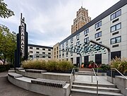
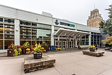
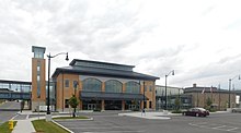
Convention Center
Niagara Falls Convention Center (NFCC)
From 1973 to 2002, the city had a Convention and Civic Center on 4th street. In 2002 the venue was converted into the Seneca Niagara Casino & Hotel. In 2004, a new Niagara Falls Convention Center (NFCC) opened on Old Falls Street. The Old Falls Street venue has 116,000 square feet for exhibitions and meetings, and a 32,200-square-foot event/exhibit hall.[35]
Attractions in the downtown include the Seneca Niagara Casino & Hotel and Pine Avenue which was historically home to a large Italian American population and is now known as Little Italy for its abundance of shops and quality restaurants.
The City of Niagara Falls functions under a strong mayor-council form of government. The government consists of a mayor, a professional city administrator, and a city council. The current mayor is Robert Restaino.
The city council serves four-year, staggered terms, except in the case of a special election. It is headed by a chairperson, who votes in all items for council action.
On a state level, Niagara Falls is part of the 145th Assembly District of New York State, represented by Republican Angelo Morinello. Niagara Falls is also part of the 62nd Senate District of New York State, represented by Republican Robert Ortt.
Founded in 1892 Niagara Falls Police Department provide local law enforcement in the city with 155 sworn officers.[36] This force is not to be mistaken for the Town of Niagara, New York which has a smaller force founded in 1954.
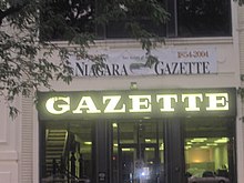
The city has two local newspapers, the Niagara Gazette, which is published daily except Tuesday and The Messenger Of Niagara Falls, NY which is published quarterly. The Messenger Of Niagara Falls, NY, which is officially Niagara Falls, New York's, first black-owned and operated news publication, founded October 2018. The Messenger Of Niagara Falls, NY published its inaugural issue April 2019. The Buffalo News is the closest major newspaper in the area. The city also is the home to a weekly tabloid known as the Niagara Falls Reporter.
Three radio stations are licensed to the city of Niagara Falls, including WHLD AM 1270, WEBR AM 1440, and WTOR AM 770.
Infrastructure
Niagara Falls is primarily served by the Buffalo Niagara International Airport for regional and domestic flights within the United States. The recently expanded Niagara Falls International Airport serves the city, and many cross border travellers with flights to Myrtle Beach, Fort Lauderdale, Orlando and Punta Gorda. Toronto's Pearson International Airport on the Canadian side is the closest airport offering long-haul international flights for the Niagara region.
Niagara Frontier Transportation Authority is the public transit provider in the Buffalo metro area, with hubs at the Portage Road and Niagara Falls transportation centers.
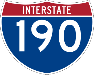
Interstate 190, also referred to as the Niagara Expressway, is a north–south highway and a spur of Interstate 90 which borders the eastern end of the city. The highway enters the city from the town of Niagara and exits at the North Grand Island Bridge. U.S. Route 62, known as Niagara Falls Boulevard, Walnut Avenue, and Ferry Avenue, is signed as a north–south highway. U.S. Route 62 has an east–west orientation, and is partially split between two one-way streets within Niagara Falls. Walnut Avenue carries U.S. Route 62 west to its northern terminus at NY 104, and Ferry Avenue carries U.S. Route 62 east from downtown Niagara Falls. U.S. Route 62 Business, locally known as Pine Avenue, is an east–west route which parallels U.S. Route 62 to the south. Its western terminus is at NY 104, and its eastern terminus is at U.S. Route 62.
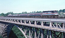
Two international bridges connect the city to Niagara Falls, Ontario. The Rainbow Bridge connects the two cities with passenger and pedestrian traffic and overlooks the Niagara Falls, while the Whirlpool Rapids Bridge, which formerly carried the Canadian National Railway, now serves local traffic and Amtrak's Maple Leaf service.
Erie County is a county along the shore of Lake Erie in western New York State. As of the 2020 census, the population was 954,236. The county seat is Buffalo, which makes up about 28% of the county's population. Both the county and Lake Erie were named for the regional Iroquoian language-speaking Erie tribe of Native Americans, who lived in the area before 1654. They were later pushed out by the more powerful Iroquoian nations tribes. The county is part of the Western New York region of the state.
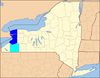
Niagara County is in the U.S. state of New York. As of the 2020 census, the population was 212,666. The county seat is Lockport. The county name is from the Iroquois word Onguiaahra; meaning the strait or thunder of waters. The county is part of the Western New York region of the state.
Grand Island is an island town in Erie County, New York, United States. As of the 2020 census, the town's population was 21,389 representing an increase of 5.00% from the 2010 census figure. The town's name is derived from the French name La Grande Île; Grand Island is the largest island in the Niagara River and the third largest in New York state. The phrase La Grande Île appears on the town seal.
Cheektowaga is a town in Erie County, New York, United States. As of the 2020 census, the town has grown to a population of 89,877. The town is in the north-central part of the county, and is an inner ring suburb of Buffalo. The town is the second-largest suburb of Buffalo, after the Town of Amherst.
Tonawanda is a town in Erie County, New York, United States. As of the 2020 census, the town had a population of 72,636. The town is at the north border of the county and is the northern inner ring suburb of Buffalo. It is sometimes referred to, along with its constituent village of Kenmore, as "Ken-Ton". The town was established in 1836, and up to 1903 it included what is now the city of Tonawanda.
Lewiston is a town in Niagara County, New York, United States. The population was 15,944 at the 2020 census. The town and its contained village are named after Morgan Lewis, a governor of New York.
The Niagara Frontier Transportation Authority (NFTA) is the public agency responsible for operating most public transportation services in the Buffalo–Niagara Falls metropolitan area. The NFTA, as an authority, oversees a number of subsidiaries, including the NFTA Metro bus and rail system, the Buffalo-Niagara International Airport, the Niagara Falls International Airport and NFTA Small Boat Harbor. The NFTA Metro bus and rail system is a multi-modal agency, utilizing various vehicle modes, using the brand names: NFTA Metro Bus, NFTA Metro Rail, NFTA Metrolink and NFTA PAL. In 2023, the system had a ridership of 15,429,900, or about 53,600 per weekday as of the fourth quarter of 2023.
Interstate 190 is a north–south auxiliary Interstate Highway in the United States that connects I-90 in Buffalo, New York, with the Canada–United States border at Lewiston, New York, near Niagara Falls. Officially, I-190 from I-90 north to New York State Route 384 (NY 384) is named the Niagara Thruway and is part of the New York State Thruway system. The remainder, from NY 384 to Lewiston, is known as the Niagara Expressway and is maintained by the New York State Department of Transportation (NYSDOT).
The Niagara Scenic Parkway is a 16.4-mile (26.39 km) north-south parkway in western Niagara County, New York, in the United States. Its southern terminus is at the LaSalle Expressway on the east bank of the Niagara River in Niagara Falls. The northern terminus is at New York State Route 18 (NY 18) at Four Mile Creek State Park in Porter near Lake Ontario. Originally, the parkway was one continuous road; however, due to low usage, a portion of the parkway near Niagara Falls was removed, separating the parkway into two sections. The length of the parkway is designated as New York State Route 957A by the New York State Department of Transportation (NYSDOT). A 1.16-mile (1.87 km) long spur connecting the Niagara Scenic Parkway to Fort Niagara State Park near Youngstown is designated as New York State Route 958A. Both reference route designations are unsigned.
New York State Route 265 (NY 265) is a 19.75-mile (31.78 km) long state highway located in the western part of New York in the United States. NY 265 is a north–south route that roughly parallels the western parts of the Niagara River in Erie County and Niagara County. For much of its southern course, it is more frequently referred to by its longtime name, Military Road, which dates back to 1801 as a road to connect the city of Black Rock and Fort Niagara near Lake Ontario.
New York State Route 384 (NY 384) is a state highway in Western New York in the United States. It is a north–south route extending from the city of Buffalo, Erie County to the city of Niagara Falls, Niagara County, and is one of several routes directly connecting the two cities. The southern terminus of the route is at NY 5 in downtown Buffalo. NY 384's northern terminus is at the Rainbow Bridge in downtown Niagara Falls. Through its entire course in Erie County, it is known as Delaware Avenue for the street it follows in the city. In Niagara County, NY 384 follows the Niagara River and is named River Road and Buffalo Avenue.
The LaSalle Expressway is a 2.62-mile-long (4.22 km) freeway in Niagara County, New York, in the United States. It begins near the North Grand Island Bridge at an interchange with Interstate 190 (I-190) in Niagara Falls and ends just south of the Niagara Falls International Airport at Williams Road (NY 952V) in Wheatfield. The LaSalle Expressway is part of New York State Route 951A (NY 951A), an unsigned reference route; the other, 0.42-mile (0.68 km) portion is located along Niagara Street between the Rainbow Bridge and Fifth Street in downtown Niagara Falls. Most of this portion, which is not connected to the LaSalle Expressway, is also part of the signed NY 384.
New York State Route 61 (NY 61) is a state highway located almost entirely in the city of Niagara Falls in Niagara County, New York, in the United States. The road runs across the city in a northwest–southeast direction, terminating at NY 384 at its southern extent and NY 104 at its northern tip. Conceptually, the road, known as Hyde Park Boulevard, forms the eastern border of downtown Niagara Falls. It is the second-shortest two-digit route in New York after NY 71 in Columbia County. The NY 61 designation was in 1958 after being approved by the Niagara Falls City Council.
Since the Buffalo Metro Rail light rail was proposed in the 1970s, there have been multiple proposals for expanding the system, which is currently a single 6.4-mile (10.3 km) long line. Public officials, agencies and advocacy groups have created plans, with the most recent and extensive being an extension to the town of Amherst. Groups have formed on both sides of the issue.
The International Railway Company (IRC) was a transportation company formed in a 1902 merger between several Buffalo-area interurban and street railways. The city railways that merged were the West Side Street Railway, the Crosstown Street Railway and the Buffalo Traction Company. The suburban railroads that merged included the Buffalo & Niagara Electric Street Railway, and its subsidiary the Buffalo, Lockport & Olcott Beach Railway; the Buffalo, Depew & Lancaster Railway; and the Niagara Falls Park & River Railway. Later the IRC acquired the Niagara Gorge Railroad (NGRR) as a subsidiary, which was sold in 1924 to the Niagara Falls Power Company. The NGRR also leased the Lewiston & Youngstown Frontier Railroad.
U.S. Route 62 is a part of the U.S. Highway System that travels from the United States–Mexico border at El Paso, Texas, to Niagara Falls, New York. In the U.S. state of New York, US 62 extends 102.77 miles (165.39 km) from the New York–Pennsylvania border south of Jamestown to an intersection with New York State Route 104 in downtown Niagara Falls, bypassing the city of Jamestown and serves the cities of Buffalo and Niagara Falls, along with several villages. It is the only north–south mainline U.S. highway in Western New York. US 62 was extended into New York c. 1932 and originally was concurrent with the state highways that had previously been designated along its routing—namely NY 18, NY 60, NY 83 and NY 241. These concurrencies were eliminated individually during the 1940s and 1960s. The last of the four concurrencies, with NY 18 from Dayton to Niagara Falls, was removed c. 1962. US 62 has one special route, US 62 Business, located in Niagara Falls. US 62 Business is a former routing of US 62 within the city and was once NY 62A.
Deveaux School Historic District is a national historic district located at Niagara Falls in Niagara County, New York.
Transportation in Buffalo, New York is dominated by automobile use, but other modes of transportation exist in the city.
Arthur Schoellkopf was an American industrial leader who helped develop the hydroelectric resources of Niagara Falls and served as the fifth Mayor of Niagara Falls, New York.
↑ "Station: Niagara Falls, NY". U.S. Climate Normals 2020: U.S. Monthly Climate Normals (1991–2020). National Oceanic and Atmospheric Administration. Retrieved August 9, 2021.
↑ see map for boundaries the area corresponding to a region with boundaries around the text City of Niagara Falls
Mah, Alice. Industrial Ruination, Community, and Place: Landscapes and Legacies of Urban Decline (University of Toronto Press; 2012) 240 pages; comparative study of urban and industrial decline in Niagara Falls (Canada and the United States), Newcastle upon Tyne, Britain, and Ivanovo, Russia.
This page is based on this Wikipedia article Text is available under the CC BY-SA 4.0 license; additional terms may apply. Images, videos and audio are available under their respective licenses.