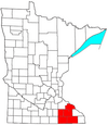
Wabasha County is a county in the U.S. state of Minnesota. As of the 2020 census, the population was 21,387. Its county seat is Wabasha.

Olmsted County is a county in the U.S. state of Minnesota. As of the 2020 census, the population is 162,847. Its county seat and most populous city is Rochester.

Goodhue County is a county in the U.S. state of Minnesota. As of the 2020 census, the population was 47,582. Its county seat is Red Wing. Nearly all of Prairie Island Indian Community is within the county.
Dodge County is a county in the U.S. state of Minnesota. The population was 20,867 as of the 2020 census. Its county seat is Mantorville.

Hayfield is a city in Dodge County, Minnesota, United States. The population was 1,340 at the 2010 census.

Kasson is a city in Dodge County, Minnesota, United States. The population was 6,851 at the 2020 census. The city is located 13 miles (21 km) west of Rochester along U.S. Highway 14 and is one of the endpoints of Minnesota State Highway 57. The Dakota, Minnesota and Eastern Railroad's main freight rail line also runs through the city. Kasson shares a school system with nearby Mantorville. The K–M school system is a member of the Zumbro Education school district (ZED). Kasson is part of the Rochester, MN Metropolitan Statistical Area.

Oronoco is a city in Olmsted County, Minnesota, United States, along the Middle Fork of the Zumbro River. The population was 1,802 at the 2020 census.

Mazeppa is a city in Wabasha County, Minnesota, United States, along the North Fork of the Zumbro River. The population was 874 at the 2020 census.

Mazeppa Township is a township in Wabasha County, Minnesota, United States. The population was 743 at the 2000 census. Mazeppa Township was organized in 1858 and named in honor of Ivan Mazepa, a 17th-century Cossack chief popularized by Lord Byron's poem "Mazeppa".

Zumbro Falls is a city along the Zumbro River in Wabasha County, Minnesota, United States. The population was 155 at the 2020 census. U.S. Highway 63 and Minnesota 60 intersect in Zumbro Falls.
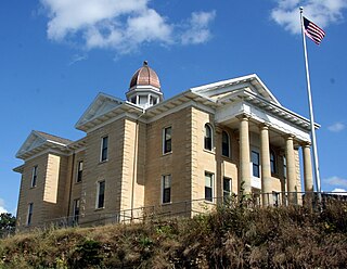
Mantorville is a city in Dodge County, Minnesota, United States. The population was 1,197 at the 2010 census. It is the county seat of Dodge County. Founded in 1854, the city is one of the oldest in Minnesota.

Area code 507 is a telephone area code in the North American Numbering Plan for the southern fifth of Minnesota, including cities such as Rochester, Mankato, Worthington, Fairmont, Albert Lea, Northfield, and Austin. It was the third area code created for use in the state in 1954, following the original 218 and 612. It was created from the southwestern portion of 218 and the southern portion of 612.

In the U.S. state of Minnesota, a legislative route is a highway number defined by the Minnesota State Legislature. The routes from 1 to 70 are constitutional routes, defined as part of the Babcock Amendment to the Minnesota State Constitution, passed November 2, 1920. All of them were listed in the constitution until a 1974 rewrite. Though they are now listed separately in §161.114 of the Minnesota Statutes, the definitions are legally considered to be part of the constitution, and cannot be altered or removed without an amendment. Legislative routes with numbers greater than 70 can be added or deleted by the legislature.
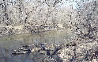
The Zumbro River is a tributary of the Mississippi River in the Driftless Area of southeastern Minnesota in the United States. It is 64.6 miles (104.0 km) long from the confluence of its principal tributaries and drains a watershed of 1,428 square miles (3,700 km2). The river's name in English is a change from its French name Rivière des Embarras due to its mouth near Pine Island in the Mississippi River; the pronunciation changed from to. The Dakota name for this river is Wapka Wazi Oju, having reference to the grove of great white pines at Pine Island.

Minnesota State Highway 42 (MN 42) is a 30.717-mile-long (49.434 km) highway in southeast Minnesota, which runs from its interchange with Interstate 90 near Eyota and continues north and northeast to its northern terminus at its intersection with U.S. Highway 61 in Kellogg.
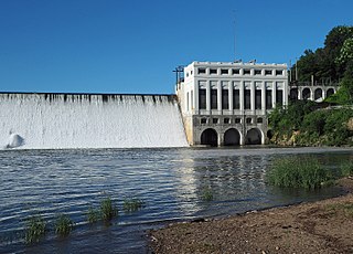
The Lake Zumbro Hydroelectric Generating Plant, also known as the City of Rochester Municipal Hydro-Electric Plant, is a hydroelectric facility on the Zumbro River in Mazeppa and Zumbro Townships in the U. S. State of Minnesota. The facility consists of a gravity dam and a powerhouse, and formerly included three houses for the plant operators. The houses were removed in the 1960s when the dam was retrofitted to allow remote operation of the generating equipment from Rochester. The impoundment created is called Lake Zumbro. This dam spans 904 feet (276 m) and is 66 feet (20 m) high, creating a reservoir with about 55 feet (17 m) of hydraulic head.
South Troy is an unincorporated community in Zumbro Township, Wabasha County, Minnesota, United States. It is located on U.S. Highway 63 about 13 miles north of Rochester. Nearby places include Hammond, Zumbro Falls, Mazeppa, Potsdam, and Oronoco. Wabasha County Roads 7 and 11 are nearby.

The Weirton–Steubenville, WV–OH Metropolitan Statistical Area, also known as the Upper Ohio Valley, is a metropolitan statistical area consisting of two counties in the Northern Panhandle of West Virginia and one in Ohio, anchored by the cities of Weirton and Steubenville. As of the 2020 census, the MSA had a population of 116,903. This puts it at 334th largest in the United States. It is also included in the larger Pittsburgh–New Castle–Weirton, PA–OH–WV Combined Statistical Area.
Oak Center is an unincorporated community in Gillford Township, Wabasha County, Minnesota, United States.
The Southern Football Alliance is a mega-conference for high school football in southeast Minnesota. It was formed in March 2013 and is the combination of schools that belong to both the Three Rivers Conference and the Hiawatha Valley League for other sports. The alliance is divided into three divisions, Red, White, and Blue, based on each school's enrollment.