
The Blacksburg-Christiansburg Metropolitan Statistical Area, formerly the Blacksburg-Christiansburg-Radford Metropolitan Statistical Area, is a Metropolitan Statistical Area (MSA) as defined by the United States Office of Management and Budget (OMB) located in the New River Valley of Southwest Virginia. As of the 2020 census, the MSA had a population of 181,863.

The Lynchburg Metropolitan Statistical Area is a United States Metropolitan Statistical Area (MSA) in the state of Virginia, as defined by the Office of Management and Budget (OMB) as of June 2003. As of the 2000 census, the MSA had a population of 228,616. In 2009 this was estimated to have risen to 247,447; as of 2016, the Lynchburg MSA was estimated to have a population of 260,320, making it the fifth-largest metro area in the state.

Northwestern Illinois is a geographic region of the state of Illinois within the USA.
The Charleston Metropolitan Statistical Area, as defined by the United States Census Bureau, is an area consisting of three counties in West Virginia, anchored by the city of Charleston. It is the largest metropolitan area entirely within the state of West Virginia. The Huntington Metro Area adds to the Charleston–Huntington, WV-OH-KY CSA and spans three states, while the core county of the Charleston area, Kanawha County, is more populous than the West Virginia portion of the Huntington area.
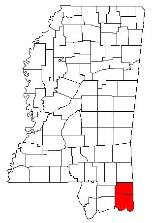
The Pascagoula Metropolitan Statistical Area was a metropolitan area in the southeastern corner of Mississippi that covered two counties - Jackson and George. As of the 2000 census, the MSA had a population of 150,564. The area was significantly impacted by Hurricane Katrina in 2005. A July 1, 2009 estimate placed the population at 155,603. Prior to the hurricane, the area had experienced steady population growth. It was also part of the larger Gulfport-Biloxi-Pascagoula Combined Statistical Area.

The Athens-Clarke County Metropolitan Statistical Area, as defined by the United States Census Bureau, is an area consisting of four counties - Clarke, Madison, Oconee, and Oglethorpe - in northeastern Georgia, anchored by the city of Athens. As of the 2020 census, the MSA had a population of 215,479.

The Fayetteville, NC Metropolitan Statistical Area, as defined by the US Office of Management and Budget (OMB), is an area consisting of three counties – Cumberland, Harnett, and Hoke – in eastern North Carolina, anchored by the city of Fayetteville. It is served by Interstate 95, Interstate 295, U.S. and state highways, Fayetteville Regional Airport, Amtrak, Greyhound, Megabus and several railroad systems. As of the 2000 census, the MSA had a population of 336,609. As of the 2010 census the MSA had a population of 366,383. In 2011 the estimated population was 374,157. The 2019 estimated population is 526,719.
The Point Pleasant Micropolitan Statistical Area, as defined by the United States Census Bureau, is an area consisting of two counties – one in West Virginia and one in Ohio – anchored by the city of Point Pleasant, West Virginia.

The Parkersburg–Vienna metropolitan area, officially the Parkersburg–Vienna, WV Metropolitan Statistical Area as defined by the United States Census Bureau, is an area consisting of two counties in West Virginia, anchored by the cities of Parkersburg and Vienna. As of the 2020 census, the MSA had a population of 89,490. Prior to the 2020 census, the metro area included the city of Marietta, Ohio and Washington County, which has since been redefined as its own micropolitan area. They now form the Parkersburg–Marietta–Vienna, WV–OH Combined Statistical Area.

The Anchorage Metropolitan Statistical Area, as defined by the United States Census Bureau, is an area consisting of the Municipality of Anchorage and the Matanuska-Susitna Borough in the south central region of Alaska.

The Logan Metropolitan Statistical Area, as defined by the United States Census Bureau, is an area consisting of two counties – one in Utah and one in Idaho, anchored by the city of Logan. As of the 2010 census, the MSA had a population of 125,442. As of the 2020 Census, the population had risen to 147,908, and further expanded to an estimated 155,362 as of 2022. The Logan metropolitan area is colloquially called Cache Valley, where most of the population resides.

The Salisbury, MD Metropolitan Statistical Area is a United States Census Bureau-designated metropolitan area centered in and around Salisbury, Maryland, including two counties in Maryland: Somerset and Wicomico. Until 2023, the Salisbury MSA also included Worcester County.

The Grand Island metropolitan area, as defined by the United States Census Bureau, is an area consisting of four counties in Nebraska, anchored by the city of Grand Island. It was upgraded from a micropolitan area and Hamilton County was added in 2012 when Grand Island's population surpassed 50,000.

The Victoria Metropolitan Statistical Area, as defined by the United States Census Bureau, is an area consisting of three counties in the Coastal Bend region of Texas, anchored by the city of Victoria. The area is sometimes referred to as the Golden Crescent Region, though this term is sometimes used to refer to a larger area than just these 3 counties. As of the 2000 census, the MSA had a population of 111,663.
The Tullahoma–Manchester Micropolitan Statistical Area, as defined by the United States Census Bureau, is an area consisting of two counties in central Tennessee, anchored by the cities of Tullahoma and Manchester.

The New Bern micropolitan statistical area, as defined by the United States Census Bureau, is an area consisting of three counties in the Inner Banks region of eastern North Carolina, anchored by the city of New Bern. The designation of the area was changed from Micropolitan to Metropolitan in 2013.
The Paducah, KY–IL Metropolitan Statistical Area, as defined by the United States Census Bureau, is an area consisting of five counties – three in the Jackson Purchase region of Kentucky, a fourth Kentucky county bordering the Purchase, and one in Southern Illinois – anchored by the city of Paducah, Kentucky. The Paducah KY-IL Micropolitan Statistical Area was upgraded to Metropolitan Statistical Area (MSA) status on July 21, 2023, by the Office of Management and Budget.. Carlisle County, Kentucky, was added to the area following the 2020 Census of the Population. The total MSA population from the 2020 United States Census was 103,486.

The Camden Micropolitan Statistical Area, as defined by the United States Census Bureau, is an area consisting of two counties in the U.S. state of Arkansas, anchored by the city of Camden.
The Kokomo Metropolitan Statistical Area, as defined by the United States Census Bureau, is an area consisting of Howard County in Indiana. Howard County had a population estimate of 83,831 in 2023. Kokomo is also the principal city of the area known as North Central Indiana, the area around Kokomo with economic ties. The six county area including Cass, Clinton, Fulton, Howard, Miami, and Tipton counties had population of 228,331 people in 2010.

The Hilton Head Island metropolitan area, officially the Hilton Head Island–Bluffton–Port Royal, SC Metropolitan Statistical Area as defined by the United States Census Bureau, is a metropolitan statistical area consisting of the two southernmost counties in the Lowcountry region of South Carolina, centered on the resort town of Hilton Head Island. As of the 2020 census, the MSA had a population of 215,908. Prior to March 2013, the region was considered a micropolitan statistical area.


