Franklin County, Illinois

Last updated

Franklin County
Franklin County Courthouse.jpg
Flag of Franklin County, Illinois.svg
Map of Illinois highlighting Franklin County.svg
Location within the U.S. state of Illinois
Illinois in United States.svg
Illinois's location within the U.S.
Coordinates: 37°59′N88°55′W / 37.99°N 88.92°W / 37.99; -88.92
CountryFlag of the United States.svg United States
StateFlag of Illinois.svg  Illinois
FoundedJanuary 2, 1818
Named for Benjamin Franklin
Seat Benton
Largest city West Frankfort
Area
  Total432 sq mi (1,120 km2)
  Land409 sq mi (1,060 km2)
  Water23 sq mi (60 km2)  5.2%
Population
 (2020)
  Total37,804 Decrease2.svg
  Density88/sq mi (34/km2)
Time zone UTC−6 (Central)
  Summer (DST) UTC−5 (CDT)
Congressional district 12th
Website www.franklincountyil.gov

Franklin County is a county in Southern Illinois. At the 2020 census, it had a population of 37,804. [1] The largest city is West Frankfort and the county seat is Benton. [2] This area of Southern Illinois is known locally as "Little Egypt".

Contents

History

Franklin County was established on January 2, 1818, and formed from parts of Gallatin and White counties. It was named for Benjamin Franklin. [3]

Coal mining

Coal was mined in Franklin County as early as 1889, at the King Coal Mine, located at Township 5 South, Range 3 East. [4]

The high levels of gas found in Franklin County's coal deposits have resulted in mining disasters and explosions over the years. [5] Between 1905 and 1968, there were eleven mine disasters. [6] In 1905, the Zeigler No. 1 mine, located in Zeigler, had an explosion that killed about fifty people. [7] In 1917, an explosion in Old Ben Mine No. 11, located in Christopher, killed 17. [8] The worst explosion occurred in 1951, in the Orient No. 2 Mine in West Frankfort, in which 119 people died. [9]

The West Frankfort quadrangle of Franklin County is home to 17 coal mines, according to a 2004 report. [5]

Geography

According to the U.S. Census Bureau, the county has a total area of 431 square miles (1,120 km2), of which 409 square miles (1,060 km2) is land and 23 square miles (60 km2) (5.2%) is water. [10] Wayne Fitzgerrell State Recreation Area is located in this county.

Climate and weather

Benton, Illinois
Climate chart (explanation)
J
F
M
A
M
J
J
A
S
O
N
D
 
 
2.9
 
 
39
21
 
 
2.9
 
 
45
26
 
 
4.2
 
 
56
36
 
 
4.5
 
 
67
45
 
 
4.6
 
 
76
54
 
 
4.1
 
 
85
63
 
 
3.2
 
 
90
68
 
 
3
 
 
88
65
 
 
2.9
 
 
81
58
 
 
2.9
 
 
69
45
 
 
4.5
 
 
56
37
 
 
3.6
 
 
43
26
Average max. and min. temperatures in °F
Precipitation totals in inches
Source: The Weather Channel [11]
Metric conversion
J
F
M
A
M
J
J
A
S
O
N
D
 
 
74
 
 
4
−6
 
 
73
 
 
7
−3
 
 
106
 
 
13
2
 
 
114
 
 
19
7
 
 
117
 
 
24
12
 
 
103
 
 
29
17
 
 
81
 
 
32
20
 
 
77
 
 
31
18
 
 
73
 
 
27
14
 
 
75
 
 
21
7
 
 
114
 
 
13
3
 
 
90
 
 
6
−3
Average max. and min. temperatures in °C
Precipitation totals in mm

In recent years, average temperatures in the county seat of Benton have ranged from a low of 21 °F (−6 °C) in January to a high of 90 °F (32 °C) in July, although a record low of −22 °F (−30 °C) was recorded in January 1977 and a record high of 104 °F (40 °C) was recorded in August 2007. Average monthly precipitation ranged from 2.87 inches (73 mm) in February to 4.59 inches (117 mm) in May. [11]

On April 21, 1912, a tornado destroyed facilities at the Possum Ridge Mine. [5] [12]

On March 18, 1925, Franklin County was among five southern Illinois counties effected by the infamous Tri-State Tornado. The storm cut across the southern edge of the county, hitting West Frankfort and destroying most of the northern side of town, causing significant damage to the town's mining facilities. Farther to the east, the village of Parrish was also struck, and was never rebuilt. The storm killed 192 people in Franklin County, injuring hundreds more and leaving scores of people homeless.

Adjacent counties

Transit

Major highways

Demographics

Historical population
CensusPop.Note
1820 1,763
1830 4,083131.6%
1840 3,682−9.8%
1850 5,68154.3%
1860 9,39365.3%
1870 12,65234.7%
1880 16,12927.5%
1890 17,1386.3%
1900 19,67514.8%
1910 25,94331.9%
1920 57,293120.8%
1930 59,4423.8%
1940 53,137−10.6%
1950 48,685−8.4%
1960 39,281−19.3%
1970 38,329−2.4%
1980 43,20112.7%
1990 40,319−6.7%
2000 39,018−3.2%
2010 39,5611.4%
2020 37,804−4.4%
2023 (est.)37,138 [13] −1.8%
U.S. Decennial Census [14]
1790-1960 [15] 1900-1990 [16]
1990-2000 [17] 2010-2013 [1]
2000 census age pyramid for Franklin County USA Franklin County, Illinois age pyramid.svg
2000 census age pyramid for Franklin County

As of the 2010 United States Census, there were 39,561 people, 16,617 households, and 10,912 families residing in the county. [18] The population density was 96.8 inhabitants per square mile (37.4/km2). There were 18,525 housing units at an average density of 45.3 per square mile (17.5/km2). [10] The racial makeup of the county was 97.7% white, 0.3% Asian, 0.3% American Indian, 0.3% black or African American, 0.3% from other races, and 1.1% from two or more races. Those of Hispanic or Latino origin made up 1.2% of the population. [18] In terms of ancestry, 21.8% were German, 18.7% were Irish, 15.9% were English, 9.4% were American, and 5.7% were Italian. [19]

Of the 16,617 households, 30.0% had children under the age of 18 living with them, 48.8% were married couples living together, 11.6% had a female householder with no husband present, 34.3% were non-families, and 30.0% of all households were made up of individuals. The average household size was 2.35 and the average family size was 2.88. The median age was 41.8 years. [18]

The median income for a household in the county was $34,381 and the median income for a family was $43,170. Males had a median income of $39,122 versus $28,950 for females. The per capita income for the county was $18,504. About 14.5% of families and 19.8% of the population were below the poverty line, including 30.5% of those under age 18 and 9.9% of those age 65 or over. [20]

Communities

Cities

Villages

Map of Franklin County, Illinois Townships.Franklin.Co.map.png
Map of Franklin County, Illinois

Census-designated place

Townships

Franklin County is divided into twelve townships:

Unincorporated communities

Education

Regional

Primary and secondary

Higher education

Specialized

Politics

Franklin County voted mostly for Democratic US presidential candidates until 2000. Since then it has voted for Republican presidential nominees.

United States presidential election results for Franklin County, Illinois [30]
Year Republican Democratic Third party
No.%No.%No.%
2020 13,62272.97%4,76025.50%2871.54%
2016 13,11670.10%4,72725.26%8684.64%
2012 10,26757.31%7,25440.49%3932.19%
2008 9,40450.25%8,88047.45%4302.30%
2004 10,38853.68%8,81645.56%1480.76%
2000 8,49044.19%10,20153.10%5212.71%
1996 5,35430.84%9,81456.54%2,19012.62%
1992 5,50425.62%12,74459.33%3,23315.05%
1988 7,67740.87%11,02358.69%830.44%
1984 9,65647.39%10,66752.35%540.27%
1980 9,73149.01%9,42547.47%7003.53%
1976 7,42036.51%12,81863.07%860.42%
1972 10,12154.04%8,54545.62%630.34%
1968 9,03642.88%10,09547.90%1,9439.22%
1964 7,62035.94%13,58164.06%00.00%
1960 11,86150.98%11,36848.86%370.16%
1956 11,76150.98%11,30849.02%00.00%
1952 11,72349.33%11,98150.41%620.26%
1948 9,40743.87%11,75054.79%2871.34%
1944 11,37749.01%11,66350.24%1730.75%
1940 12,93645.14%15,52354.16%2010.70%
1936 10,70840.22%15,25457.29%6632.49%
1932 7,56032.46%14,75463.35%9764.19%
1928 9,90045.79%11,36952.58%3531.63%
1924 6,77939.59%5,79133.82%4,55126.58%
1920 7,60851.11%4,89432.88%2,38416.02%
1916 6,37146.42%6,41946.77%9346.81%
1912 2,09836.12%2,43541.92%1,27621.97%
1908 2,53948.52%2,40145.88%2935.60%
1904 2,07750.04%1,80143.39%2736.58%
1900 2,11747.99%2,22650.46%681.54%
1896 2,03847.43%2,23351.97%260.61%
1892 1,63144.25%1,78248.35%2737.41%

See also

Related Research Articles

<span class="mw-page-title-main">Williamson County, Illinois</span> County in Illinois, United States

Williamson County is a county in Southern Illinois. At the 2020 census, it had a population of 67,153. The largest city and county seat is Marion.

<span class="mw-page-title-main">Jefferson County, Illinois</span> County in Illinois, United States

Jefferson County is a county located in the southern part of the U.S. state of Illinois. According to the 2020 census, it has a population of 37,113. The county seat is Mount Vernon.

<span class="mw-page-title-main">Buckner, Illinois</span> Village in Illinois, United States

Buckner is a village in Franklin County, Illinois, United States. The population was 409 at the 2020 census. The current mayor is Aaron Eubanks.

<span class="mw-page-title-main">North City, Illinois</span> Village in Illinois, United States

North City is a village in Franklin County, Illinois, United States. As of the 2020 census, the population was 509. North City is also known as "Coello". The current mayor is Curtis Overton.

<span class="mw-page-title-main">Royalton, Illinois</span> Village in Illinois, United States

Royalton is a village in Franklin County, Illinois, United States. The population was 1,068 at the 2020 census.

<span class="mw-page-title-main">Sesser, Illinois</span> City in Illinois, United States

Sesser is a city in Franklin County, Illinois, United States. The population was 1,888 at the 2020 census. The current mayor is C. Jason Ashmore.

<span class="mw-page-title-main">Thompsonville, Illinois</span> Village in Illinois, United States

Thompsonville is a village in Cave Township, Franklin County, Illinois, United States. The population was 486 at the 2020 census.

<span class="mw-page-title-main">Valier, Illinois</span> Village in Illinois, United States

Valier is a village in Franklin County, Illinois, United States. The population was 554 at the 2020 census.

<span class="mw-page-title-main">West Frankfort, Illinois</span> City in Illinois, United States

West Frankfort is a city in Franklin County, Illinois. The population was 7,275 at the 2020 census. The city is well known for its rich history of coal. The city is part of the Metro Lakeland area.

<span class="mw-page-title-main">Zeigler, Illinois</span> City in Illinois, United States

Zeigler is a city in Franklin County, Illinois, United States. The population was 1,484 at the 2020 census.

<span class="mw-page-title-main">Bald Hill Township, Jefferson County, Illinois</span> Township in Illinois, United States

Bald Hill Township is one of sixteen townships in Jefferson County, Illinois, USA. As of the 2010 census, its population was 767 and it contained 359 housing units.

<span class="mw-page-title-main">Barren Township, Franklin County, Illinois</span> Township in Illinois, United States

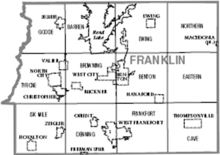
Barren Township is one of twelve townships in Franklin County, Illinois, USA. As of the 2020 census, its population was 551 and it contained 248 housing units.

<span class="mw-page-title-main">Browning Township, Franklin County, Illinois</span> Township in Illinois, United States

Browning Township is one of twelve townships in Franklin County, Illinois, USA. At the 2020 census, its population was 2,436 and it contained 1,161 housing units.

<span class="mw-page-title-main">Denning Township, Franklin County, Illinois</span> Township in Illinois, United States

Denning Township is one of twelve townships in Franklin County, Illinois, USA. As of the 2020 census, its population was 4,729 and it contained 2,352 housing units.

<span class="mw-page-title-main">Goode Township, Franklin County, Illinois</span> Township in Illinois, United States

Goode Township is one of twelve townships in Franklin County, Illinois, USA. As of the 2020 census, its population was 2,652 and it contained 1,284 housing units.

<span class="mw-page-title-main">Tyrone Township, Franklin County, Illinois</span> Township in Illinois, United States

Tyrone Township is one of twelve townships in Franklin County, Illinois, USA. As of the 2020 census, its population was 4,706 and it contained 2,330 housing units.

<span class="mw-page-title-main">John E. Bradley</span> American politician

John Bradley is a former Democratic member of the Illinois House of Representatives, representing the 117th District from his appointment in June 2003 to his resignation in January 2017. He served as an Assistant Majority Leader from 2013 to 2017. The 117th district, located in Southern Illinois and parts of the Metro Lakeland area, includes all or parts of Benton, Buckner, Bush, Cambria, Carbondale, Carterville, Christopher, Colp, Crab Orchard, Creal Springs, Energy, Ewing, Freeman Spur, Granville, Hanaford, Herrin, Hurst, Johnston City, Macedonia, Marion, McLeansboro, Mulkeytown, North City, Orient, Pittsburg, Royalton, Sesser, Spillertown, Stonefort, Thompsonville, Valier, West City, West Frankfort, Whiteash, and Zeigler.

<span class="mw-page-title-main">Black Diamond Conference</span> Illinois high school athletic conference

The Black Diamond Athletic Conference (BDC) is a high school athletic conference represented by 13 schools in the southern portion of Illinois. The conference currently offers championships for girls in basketball, cross country, golf, softball, track and field, and volleyball. In boys' sports, the BDC offers championships in baseball, basketball, cross country, football, golf, track and field, and wrestling.

Dave Severin is a Republican member of the Illinois House of Representatives, representing the 117th district since January 2017. The 117th district, located in Southern Illinois and parts of the Metro Lakeland area, includes all or parts of Benton, Buckner, Bush, Cambria, Carbondale, Carterville, Christopher, Colp, Crab Orchard, Creal Springs, Energy, Ewing, Freeman Spur, Granville, Hanaford, Herrin, Hurst, Johnston City, Macedonia, Marion, McLeansboro, Mulkeytown, North City, Orient, Pittsburg, Royalton, Sesser, Spillertown, Stonefort, Thompsonville, Valier, West City, West Frankfort, Whiteash, and Zeigler.

Jim Kirkpatrick was a Democratic member of the Illinois House of Representatives, representing the 117th district for a brief period in January 2017. He was appointed to fill the vacancy left by John Bradley's early retirement after the latter's loss to Dave Severin. The 117th district, located in Southern Illinois and parts of the Metro Lakeland area, includes all or parts of Benton, Buckner, Bush, Cambria, Carbondale, Carterville, Christopher, Colp, Crab Orchard, Creal Springs, Energy, Ewing, Freeman Spur, Granville, Hanaford, Herrin, Hurst, Johnston City, Macedonia, Marion, McLeansboro, Mulkeytown, North City, Orient, Pittsburg, Royalton, Sesser, Spillertown, Stonefort, Thompsonville, Valier, West City, West Frankfort, Whiteash, and Zeigler.

References

  1. 1 2 "State & County QuickFacts". United States Census Bureau. Archived from the original on June 6, 2011. Retrieved July 5, 2014.
  2. "Find a County". National Association of Counties. Archived from the original on May 31, 2011. Retrieved June 7, 2011.
  3. Gannett, Henry (1905). The Origin of Certain Place Names in the United States. Govt. Print. Off. pp.  131.
  4. Hinton, Wayne. "Illinois Coal & Coal Mining, History & Genealogy - Coal Mines of Franklin County, Illinois". Wayne's World of History & Genealogy. Retrieved June 24, 2018.
  5. 1 2 3 Chenowith, Cheri; Myers, Alan R (2014). "Directory of Coal Mines in Illinois, 7.5 Minute Quadrangle Series, West Frankfort Quadrangle, Franklin County" (PDF). Illinois State Geological Survey. Archived (PDF) from the original on December 29, 2015.
  6. United States Mine Rescue Association. "Mine Disasters in the United States - By County - Franklin County, IL". Mine Disasters in the United States. Retrieved June 25, 2018.
  7. United States Mine Rescue Association. "Ziegler Mine Explosion". Mine Disasters in the United States. Retrieved June 24, 2018.
  8. United States Mine Rescue Association. "Old Ben No. 11 Mine Explosion". Mine Disasters in the United States. Retrieved June 24, 2018.
  9. United States Mine Rescue Association. "Orient No. 2 Mine Explosion - West Frankfort, Illinois". Mine Disasters in the United States. Retrieved June 24, 2018.
  10. 1 2 "Population, Housing Units, Area, and Density: 2010 - County". United States Census Bureau. Archived from the original on February 12, 2020. Retrieved July 11, 2015.
  11. 1 2 "Monthly Averages for Benton, Illinois". The Weather Channel. Retrieved January 27, 2011.
  12. Hubbs, Barbara Barr. "Possum Ridge Mine History". Williamson County Illinois Historical Society. Retrieved June 24, 2018.
  13. "Annual Estimates of the Resident Population for Counties: April 1, 2020 to July 1, 2023". United States Census Bureau. Retrieved April 2, 2024.
  14. "U.S. Decennial Census". United States Census Bureau. Retrieved July 5, 2014.
  15. "Historical Census Browser". University of Virginia Library. Retrieved July 5, 2014.
  16. "Population of Counties by Decennial Census: 1900 to 1990". United States Census Bureau. Retrieved July 5, 2014.
  17. "Census 2000 PHC-T-4. Ranking Tables for Counties: 1990 and 2000" (PDF). United States Census Bureau. Archived (PDF) from the original on March 27, 2010. Retrieved July 5, 2014.
  18. 1 2 3 "DP-1 Profile of General Population and Housing Characteristics: 2010 Demographic Profile Data". United States Census Bureau. Archived from the original on February 13, 2020. Retrieved July 11, 2015.
  19. "DP02 SELECTED SOCIAL CHARACTERISTICS IN THE UNITED STATES – 2006-2010 American Community Survey 5-Year Estimates". United States Census Bureau. Archived from the original on February 13, 2020. Retrieved July 11, 2015.
  20. "DP03 SELECTED ECONOMIC CHARACTERISTICS – 2006-2010 American Community Survey 5-Year Estimates". United States Census Bureau. Archived from the original on February 13, 2020. Retrieved July 11, 2015.
  21. Franklin, Johnson, Massac, and Williamson County Regional Office of Education #21
  22. Christopher Unit School District #99
  23. Sesser Unit School District #196
  24. Benton School District #47
  25. Frankfort Community Unit School District #168
  26. Zeigler-Royalton Community Unit School District #188
  27. Thompsonville Community Unit School District #174
  28. Ewing-Northern Community Unit School District #115
  29. Franklin & Jefferson County Special Education Cooperative
  30. Leip, David. "Dave Leip's Atlas of U.S. Presidential Elections". uselectionatlas.org. Retrieved November 2, 2018.

37°59′N88°55′W / 37.99°N 88.92°W / 37.99; -88.92